Geographical Reasoning and Learning: Perspectives on Curriculum and Cartography from South America (International Perspectives on Geographical Education) 3030798461, 9783030798468
This book presents the distinctive theoretical and methodological approaches in geography education in South America and
154 76 7MB
English Pages 381 [372] Year 2021
Contents
Geography Education in South America: Curricular Frameworks, Categories of Analysis and the Role of School Cartography
Introduction
Changes in the Significance and Perspectives of Geography Education
The Contents of This Book
Conclusions
For a Powerful Geography in the Brazilian National Curriculum
Introduction
The Context of Educational Policy in Brazil
Geographic Reasoning Constructed on Real Situations
Geography in the Brazilian Common Core Curriculum
The Impact of the BNCC on Academic Research in Brazilian Geography
Conclusion
References
The Challenges Faced by the Re-contextualisation of a National Curriculum in Local Contexts: An Approach Based on the Brazilian Case
Introduction
The Brazilian National Curriculum and the Diversity Issue
Bernstein’s Contribution: Contexts, Texts and Communication Codes at School
The Policies of Equality and Diversity, and the Brazilian National School Curriculum
The Principles and Stances of School Geography in the Context of Inequality and Diversity
Final Notes: On Understanding the World and Oneself
References
Opportunities and Limitations for Spatial Justice in the Chilean National School Curriculum: An Overview of the Technologies Used in Geography Teaching
Introduction
The Chilean School Curriculum in Geography
The Completion of a Cycle
Socio-spatial Justice as Possibility and Meaning for the Learning of Geography
A Model for the Comprehension of Subjectivity, Analysing the Curriculum for Spatial Justice: Landscapes of Internalisation for the Production of Technologies
Analysis of the Chilean Curricular Bases
Results—First Cycle of Elementary Education
Ready-Made Technologies of Location
Technologies of Personal Orientation
Technologies of Discovery
Summary of the Cycle and the Problem of Spatial Justice Through the Analysis of Technologies
Results—Second Cycle
Technologies of Representation, Adaptation, and Transformation
Technologies of Classification: Physical Description of Chile with a Deterministic Approach
Technologies of Risk
Technologies of the Political-Administrative Region
Summary of the Second Cycle
Results—Third Cycle (Chilean Secondary Education)
Summary of the Third Cycle
Technologies of Contemporary Geography
Conclusions
References
The Social Sciences Curriculum in Colombia: A Proposal for the Strengthening of Geography Teaching in the Country
Introduction
A Review of Geography Teaching Policy in Colombia
The Gradual Disappearance of Geography
The Gradual Disappearance of Geography
Geography Teaching: Legislation and School Curricula
Transformations of the Educational Legislation on the Social Sciences in Colombia
Curricular Proposals at Specific Educational Institutions
The Conceptual and Methodological Proposal
What to Teach?
How to Teach It?
A Curricular Proposal for Geography Teaching in Colombia
Reflection on the Use of Resources Such as Textbooks
Conclusions
References
The Path of School Cartography in Brazilian Geographic Education
Introduction
School Cartography in Brazil
The Dissemination of Cartography to Children and Students
The Power of School Cartography: From Mental Maps to Thematic Maps
School Cartography and Spatial Thinking: Future Movements
References
Spatial Thinking: A Bibliometric Analysis (1970–2019)
Introduction
Methods
Results
Discussion
Final Considerations
References
Dealing with Words to Deal with the World: How Can We Use the Geographic Education Vocabulary in Learning Pathways?
Introduction
The Taxonomy of Spatial Thinking: Linking Geographic Information
Words on Maps: Maps as Layers of Geographic Information
Dealing with Words: A Spatial Vocabulary?
Dealing with the World: Learning the Outcomes of Pathways
Stage 1: Perception
Stage 2: Situation and Location
Stage 3: Investigation
Stage 4: Creation and Action
Summary
Conclusions
References
Territory: Pedagogical Potential for Civic Training and Political participation
Introduction
What is Meant by “Territory”?
Associated Concepts: Necessary Limits
Territory: Material Path and Semanticised Social Construct
Territorial Studies: Pedagogical Potential for Geographical Education
Conclusions
References
The Landscape as a Social Construct for the Teaching of Geography
Introduction
Landscape in Geography: Sociocultural and Biophysical Interactions
School Geography and the Teaching of the Concept of Landscape in Colombia
Landscape as an Alternative to Geography Teaching and Geographical Education in Colombia
Final Considerations
References
Place as a Spatial Category for Geographic Education
Introduction
The Need for a Category
Questioning the Reference of Sense
Questioning Mutual Implication
Equipping the Category with a Theory
Place Like Methodological Artefact
Place and the Development of Spatial Thinking
Place and the Regimes of Representation
Conclusion
References
Scientific Literacy in Geography: The Use of Indicators for the Assessment of Learning
Introduction
Geographic Literacy Indicators
Data Processing and Application
Results of the Application of the Geographic Literacy Indicators (GLI)
Analysis of an Excerpt from Learning Situation I
Analysis of an Excerpt of the Reapplication of Learning Situation I
Conclusions
References
The Role of Language in the Construction of Spatial Thinking in Early Childhood Education
Introduction
Spatial Thinking and Language: Symbolic Mediation
Research and Teaching Practices
Children and Cartography: Answers
Final Considerations
References
Geography Textbooks in Brazil and the Development of Spatial Thinking in School Students Using Maps and Images
Introduction
Brazilian Geography Textbooks and Spatial Thinking: The Approach of the Present Study
Forms of Spatial Representation Found in the Geography Textbooks
Activities that Require Spatial Thinking in the Geography Textbooks
Levels of Reasoning in the Questions that Require Spatial Thinking
Cartography and Spatial Thinking in the Textbooks
Conclusion
References
Indicators of Scientific Literacy in Geographic Education
Introduction
Scientific Literacy in Geographic Education
Geographic Reasoning
What Are the SLGE Indicators?
Final Considerations
References
Cultural Manifestations in the City: Building a Critical Perception of Space
Introduction
Dialogue Between the City and Its Graffiti
The Study: Taking a Path
The City Re-signifies Learning
The Strategy in the Classroom: Mental Maps
Analysis
Conclusions
References
The Role of Argumentation in the Building of Concepts of Territory and Citizenship
Introduction
The Theoretical Framework: Territory and Citizenship
Territory and Citizenship
The Teaching and Learning Framework: Argumentation and Problem-Solving
Field Procedures: Collecting the Written Output of the Students
Study Results and Data Analysis
Final Considerations
References
Educational Resources in Geography Classes and Reflections on the Teaching Practices Used to Promote Student Learning
Introduction
The Educational Process and the Development of Spatial Thinking
Methods
The Research Context
Analysis of the Results
Conclusions
References
Cartographic Language in the Context of Geography Teaching in Brazil
Introduction
Geography at School: Procedures and Learning
Cartographic Language and Geography Teaching
Methods
Didactic Situation: Theoretical and Methodological Bases for the Development of the Pedagogical Workshops
Development of the Didactic Situation
Description of the Didactic Situation
Discussion
Conclusions
References
Perspectives on Brazilian Geography and Cartography Education Research
Introduction
The Colloquium on Cartography for Children and Students: Some Background
The Initial Joint Conference: Different Languages in the Contemporary World
A Range of Contributions
Cartography, Geography and Spatial Thinking: Research for the Future
Conclusion
References
Recommend Papers


File loading please wait...
Citation preview
International Perspectives on Geographical Education
Sonia Maria Vanzella Castellar Marcelo Garrido-Pereira Nubia Moreno Lache Editors
Geographical Reasoning and Learning Perspectives on Curriculum and Cartography from South America
International Perspectives on Geographical Education Series Editors Clare Brooks, UCL Institute of Education, London, UK Di Wilmot, Education Department, Rhodes University, Grahamstown, Eastern Cape, South Africa
This series is under the editorial supervision of the International Geography Union’s Commission on Geographical Education. Led by the priorities and criteria set out in the Commission’s Declaration on Geography Education Research, the series plays an important role in making geography education research accessible to the global community. Publications within the series are drawn from meetings, conferences and symposiums supported by the Commission. Individual book editors are selected for special editions that correspond to the Commission’s ongoing programme of work and from suitable submissions to the series editors. In this way, research published represents immediate developments within the international geography education community. The series seeks to support the development of early career researchers in publishing high quality, high impact research accounts.
More information about this series at http://www.springer.com/series/15101
Sonia Maria Vanzella Castellar · Marcelo Garrido-Pereira · Nubia Moreno Lache Editors
Geographical Reasoning and Learning Perspectives on Curriculum and Cartography from South America
Editors Sonia Maria Vanzella Castellar Faculty of Education University of Sao Paulo São Paulo, Brazil
Marcelo Garrido-Pereira Metropolitan University of Educational Sciences Santiago, Chile
Nubia Moreno Lache Distrit University Franscico José Caldas of Bogotá Bogotá, Colombia
ISSN 2367-2773 ISSN 2367-2781 (electronic) International Perspectives on Geographical Education ISBN 978-3-030-79846-8 ISBN 978-3-030-79847-5 (eBook) https://doi.org/10.1007/978-3-030-79847-5 © The Editor(s) (if applicable) and The Author(s), under exclusive license to Springer Nature Switzerland AG 2021 This work is subject to copyright. All rights are solely and exclusively licensed by the Publisher, whether the whole or part of the material is concerned, specifically the rights of translation, reprinting, reuse of illustrations, recitation, broadcasting, reproduction on microfilms or in any other physical way, and transmission or information storage and retrieval, electronic adaptation, computer software, or by similar or dissimilar methodology now known or hereafter developed. The use of general descriptive names, registered names, trademarks, service marks, etc. in this publication does not imply, even in the absence of a specific statement, that such names are exempt from the relevant protective laws and regulations and therefore free for general use. The publisher, the authors and the editors are safe to assume that the advice and information in this book are believed to be true and accurate at the date of publication. Neither the publisher nor the authors or the editors give a warranty, expressed or implied, with respect to the material contained herein or for any errors or omissions that may have been made. The publisher remains neutral with regard to jurisdictional claims in published maps and institutional affiliations. This Springer imprint is published by the registered company Springer Nature Switzerland AG The registered company address is: Gewerbestrasse 11, 6330 Cham, Switzerland
Contents
Geography Education in South America: Curricular Frameworks, Categories of Analysis and the Role of School Cartography . . . . . . . . . . . . Sonia Vanzella Castellar, Marcelo Garrido Pereira, Nubia Moreno Lache, and Simon Catling For a Powerful Geography in the Brazilian National Curriculum . . . . . . Sonia Maria Vanzella Castellar, Carolina Machado Rocha Busch Pereira, and Raul Borges Guimarães The Challenges Faced by the Re-contextualisation of a National Curriculum in Local Contexts: An Approach Based on the Brazilian Case . . . . . . . . . . . . . . . . . . . . . . . . . . . . . . . . . . . . . . . . . . . . . . . . . . . . . . . . . . . . . . Daniel Luiz Stefenon Opportunities and Limitations for Spatial Justice in the Chilean National School Curriculum: An Overview of the Technologies Used in Geography Teaching . . . . . . . . . . . . . . . . . . . . . . . . . . . . . . . . . . . . . . . Verónica Salgado Labra and Ulises Sepúlveda The Social Sciences Curriculum in Colombia: A Proposal for the Strengthening of Geography Teaching in the Country . . . . . . . . . . Mario Fernando Hurtado and Luis Guillermo Torres The Path of School Cartography in Brazilian Geographic Education . . . Sonia Maria Vanzella Castellar
1
15
33
49
71 91
Spatial Thinking: A Bibliometric Analysis (1970–2019) . . . . . . . . . . . . . . . 111 Alfredo Pereira de Queiroz Dealing with Words to Deal with the World: How Can We Use the Geographic Education Vocabulary in Learning Pathways? . . . . . . . . . 123 Igor De Paula Territory: Pedagogical Potential for Civic Training and Political participation . . . . . . . . . . . . . . . . . . . . . . . . . . . . . . . . . . . . . . . . . . . . . . . . . . . . . . 149 Alberto León Gutiérrez Tamayo and Liliana María Sánchez Mazo v
vi
Contents
The Landscape as a Social Construct for the Teaching of Geography . . . 169 Nubia Moreno Lache and Alexánder Cely Rodríguez Place as a Spatial Category for Geographic Education . . . . . . . . . . . . . . . . 185 Marcelo Garrido Pereira Scientific Literacy in Geography: The Use of Indicators for the Assessment of Learning . . . . . . . . . . . . . . . . . . . . . . . . . . . . . . . . . . . . . 211 Jerusa Vilhena de Moraes and Pâmella Bianca Rodrigues The Role of Language in the Construction of Spatial Thinking in Early Childhood Education . . . . . . . . . . . . . . . . . . . . . . . . . . . . . . . . . . . . . . 227 Paula Cristiane Strina Juliasz Geography Textbooks in Brazil and the Development of Spatial Thinking in School Students Using Maps and Images . . . . . . . . . . . . . . . . . 247 Ronaldo Goulart Duarte Indicators of Scientific Literacy in Geographic Education . . . . . . . . . . . . . 269 Márcia Cristina Urze Risette Cultural Manifestations in the City: Building a Critical Perception of Space . . . . . . . . . . . . . . . . . . . . . . . . . . . . . . . . . . . . . . . . . . . . . . . . . . . . . . . . . . 291 Camilla Rodrigues Marangão The Role of Argumentation in the Building of Concepts of Territory and Citizenship . . . . . . . . . . . . . . . . . . . . . . . . . . . . . . . . . . . . . . . . . . . . . . . . . . . 311 Livia Reis Dantas Souza Educational Resources in Geography Classes and Reflections on the Teaching Practices Used to Promote Student Learning . . . . . . . . . . 329 Iara Rosa Silva da Bustos Cartographic Language in the Context of Geography Teaching in Brazil . . . . . . . . . . . . . . . . . . . . . . . . . . . . . . . . . . . . . . . . . . . . . . . . . . . . . . . . . . 349 Waldiney Gomes de Aguiar Perspectives on Brazilian Geography and Cartography Education Research . . . . . . . . . . . . . . . . . . . . . . . . . . . . . . . . . . . . . . . . . . . . . . . . . . . . . . . . . 361 Simon Catling, Sarah Witham Bednarz, and Robert S. Bednarz
Geography Education in South America: Curricular Frameworks, Categories of Analysis and the Role of School Cartography Sonia Vanzella Castellar, Marcelo Garrido Pereira, Nubia Moreno Lache, and Simon Catling
Introduction This book brings together a number of studies and reflective essays on key issues and thematic areas in Geographical Education by scholars from three Latin American Sonia Vanzella Castellar—Academic of the University of São Paulo, São Paulo-Brazil. Member of REDLADGEO (Latin American Network of Didactics in Geography) and GEPED (Group of Study and Research in Didactic of Geography). Marcelo Garrido Pereira—Academic of the Metropolitan University of Educational Science, Santiago of Chile. Member of REDLADGEO (Latin American Network of Didactics in Geography) and NIIE (Interinstitutional Research Center Space and School). Nubia Moreno—Academic of the Francisco José Caldas District University, Bogotá D.C.-Colombia. Member of REDLADGEO (Latin American Network of Didactics in Geography) and GEOPAIDEA (Interinstitutional Investigation Group Geopaideia). Simon Catling—Professor Emeritus in Primary Education, School of Education, Oxford Brookes University, Oxford, United Kingdom. S. V. Castellar Faculty of Education, University of São Paulo-Brazil, São Paulo, Brazil e-mail: [email protected] M. Garrido Pereira (B) Department of History and Geography, Metropolitan University of Educational Science, Santiago, Chile e-mail: [email protected] N. Moreno Lache Faculty of Science and Education, Francisco José Caldas District University-Colombia, Bogotá, Colombia e-mail: [email protected] S. Catling School of Education, Oxford Brookes University, Oxford, United Kingdom e-mail: [email protected] © The Author(s), under exclusive license to Springer Nature Switzerland AG 2021 S. M. Vanzella Castellar et al. (eds.), Geographical Reasoning and Learning, International Perspectives on Geographical Education, https://doi.org/10.1007/978-3-030-79847-5_1
1
2
S. V. Castellar et al.
countries—Brazil, Chile and Colombia. These studies represent various theoreticalmethodological approaches to the teaching and learning of geographical space, which are expected to guide exploratory agendas in Latin America, and to promote the development of geographical knowledge in the region’s school-age children. The book symbolises a process of international integration, which brings together a broad community of South American researchers in Geography teaching and learning processes, who are increasingly preoccupied with the quality of geographic education around the world. The need for a book of this type became clear during the 1st International Meeting of Cartography and Spatial Thinking (IMCST), which was held at the University of São Paulo, in São Paulo, Brazil, between July the 9th and the 12th, 2018. The papers presented and debates that took place during this meeting, which involved numerous colleagues from countries such as the United Kingdom, the United States, Canada, Chile, Colombia, as well as Brazil, led to a commitment on the publication of the principal research, ideas and findings produced in South American geographic education over the past few years. We hope in particular that this initiative will promote international debate and scientific collaboration that contribute to the development of theories, scientific methods and practices that are appropriate to the reality of the challenges facing educators in South America. By extension, we hope that these advances may also contribute to the development of this field of knowledge in other countries, in particular those in the developing world. Many of the chapters in this book focus specifically on the role of the school curriculum in the implementation of pedagogical strategies, the use of categories of analysis to address potential contextualised readings of geographical space, and the role of school cartography in the development of spatial thinking and geographical reasoning. These questions are approached from a Latin American perspective. This region is undergoing a series of transformations, and is characterised by socio-cultural traditions linked to an enormous diversity of everyday experiences. Given this, we hope to provided a balanced perspective, which covers the distinct viewpoints of geographical education in the three focus countries (Brazil, Chile and Colombia), in order to establish a solid South American dimension in the international scenario, complementing the research and debates that have arisen in English language publications in countries such as the United States, Australia and the United Kingdom’s well as in other western nations. We believe this novel perspective will add breadth and depth to the ongoing research in geographical education, and provide new insights for the discussion of the role and value of geographical and cartographic education, in general. In this context, the chapters of this book consider the curricular structures and conceptual debates that guide the teaching of Geography at the school level in three countries. In Brazil, school Geography is a well-established, autonomous discipline with a clear role in the curricular instruments. In Chile, Geography is subsumed within the structure of the Social Sciences in primary school education, and together with History and the rest of the Social Sciences, in the secondary school curriculum. In Colombia, in turn, Geography is part of the Social Sciences throughout the school
Geography Education in South America …
3
curriculum, except for the final two years, when Geography becomes an optional subject, linked to History. The case studies presented here address distinct panoramas of geographic education in the countries of South America. A majority of these papers are presented by researchers from Brazil, which is the region’s most productive nation in the field of geographic education research, and a major player in the development of theoreticalmethodological approaches. In fact, Brazil produces the largest number of publications on topics related to the teaching and learning of Geography in Latin America, and is a home to a majority of the region’s most prominent and active research groups. It has also been the principal nucleus of the research agenda on school cartography and spatial and geographical thinking in the Latin American region for the past few decades. In particular, we hope to demonstrate how Geography and social processes are now profoundly interconnected and interdependent in the current reality of a globalised and information-based society. As the challenges that face geographic education in South America are likely to be replicated in other countries around the world, it will be important to strengthen ties among regions and reinforce international collaboration among different research groups, in order to consolidate theoretical and methodological approaches.
Changes in the Significance and Perspectives of Geography Education From the second half of the 19th century onwards and throughout the 20th century, the theoretical traditions of geographical education introduced paradigms, schools of thought and trends in the scientific field that have motivated the creation of theories, research projects and scientific approaches for the analysis of relational phenomena. From the work of scientific societies and the academic sector, the object of study of the discipline was defined in increasing detail and depth. This evolution in both practice and content also advanced geographical knowledge in schools. This allowed new generations, initially of the dominant classes, but eventually of the masses, to explore and value their spaces and histories within the perspective of the nation state as the institution that organises modern life. In this way, Geography was not only undertaken as a specialised field of knowledge in the hands of experts, but was also accepted as part of the cultural heritage that had to be taught in schools, in particular, to teach the intrinsic elements that consolidate national principles, the emotional attachment and recognition of the value of natural resources, conceived as the potential for the progress of the nation, normalised and controlled by the state. Eventually, the objectives of Geography teaching in formal school education systems evolved gradually beyond the territorial configuration of the nation state, to cover issues related to knowledge of Nature as being fundamental to the status of humans as protagonists in the definition of the places they inhabit or to provide
4
S. V. Castellar et al.
individuals with elementary locational tools that are vital for the development of other school content. For most of the 20th century, this approach was manifested through exclusively encyclopaedic, descriptive and rote teaching and learning practices, which defined the content and status of Geography in the universe of school disciplines. Following the institutional development of Geography in universities, geographical traditions were established in school education systems, with a certain connection with the scientific production of this knowledge. As the professionalisation of teachers was consolidated across Latin America, with geographical contents being mobilised in distinct ways, with the approaches and interdisciplinary dialogues contributing to the establishment of local and regional traditions. In addition to these distinctions, one of the most ample trends in Latin America was the discrepancy between the establishment of theoretical discourses and the development of debates in the field of Geography, for the mobilisation of these elements in the educational and pedagogical fields. Except for the more critical discourse found in Geography teaching in countries such as Brazil or Argentina, there was no major shift away from this more traditional approach, or even an incipient neo-positivism prior to the 1990s. From this decade onwards, however, some concepts began to be transferred from the academic universe to the objective field of Geography teaching practices, including the relational aspects of geographical space, which permitted the modification of the school traditions, amplifying the field of potential pedagogical interventions. This was made possible primarily through the principle of teaching autonomy. With the progressive shift in the focus of Geography teaching away from the strictly locational dimension of space as the central theme of the geographic content, based on the description of ‘geographical products’ and the development of rote learning skills, there was an excellent opportunity for the transformation of Geographical education in Latin America. This amplified the potential meanings of geographical space in formal educational interactions. This created the possibility for the recovery of some of the relational elements of Geography through the analytical categories of space, with the perspective for the re-organisation of school curricula through the introduction of progressive, dynamic contents rather than fixed and static elements. This change was, clearly, the result of the evolution of Geography as a discipline, but it was not due exclusively to this process. Some of the contemporary transformations of society in South America, such as an increasing socio-environmental conscience, the burgeoning inequality of urban contexts, the consolidation of the progressive dismantling of traditional productive systems in the rural scenario, differential access to resources, the dispossession of access to water and land, all accentuated demand for a Geography focused primarily on the potential for the understanding and modification of the environment. The simultaneous rise of critical and emancipatory pedagogies centred on the availability of culturally legitimised contents for the construction of the minimum conditions necessary for social justice. This also generated a level of controversy on how to train teachers beyond strictly the strictly methodological perspectives of the process. All these processes also contributed to the modification of the type of Geography that needed to be taught in schools. In many cases, the pedagogical movements led by the teachers themselves facilitated these
Geography Education in South America …
5
transformations, in particular in the context of modification of national curricula, which was often associated with the installation of governments with more liberal policies. During the 1990s, the fields of human and social sciences were permeated with shifts in epistemological, conceptual and methodological perspectives. This contributed to the identification of new viewpoints on Geography education, which initiated a process of conceptual transformation, which conferred a privileged status on Geography as a field of indispensable socio-spatial knowledge at all the different levels of educational training, both for individuals and society in general. One of the scenarios that evolved from the changes was the clear need to rethink, in the academic environment, the formative processes associated with the needs of Geography teaching in the region’s education systems. In the 21st century, scholars and researchers, as well as teachers, consolidated a specific pedagogical perspective by establishing theoretical-methodological dialogues between this perspective and the contents linked specifically to the discipline, to determine the potential strategies for the didactic interventions necessary to promote learning about geographical space. This perspective was strengthened by Geography didactics that in the formative structures of the teacher training programmes and, in particular, the research teams focusing on Geography education. In this context, the academic groups and communities concerned with the reflective analysis of geographical education and school geography began to consolidate themselves. They used the specific contents of spatial knowledge to formulate proposals for teaching and learning Geography. This teaching included spatial approaches with a strong relational emphasis, such as urban segregation, marginality, displacement and migration, the new rurality, the challenges of sustainability, disputes on public space and, more significantly, topics related to the social production of scale and the need for addressing space from its analytical categories, such as territory, landscape, place, region, environment and the geosystem. Research groups, communities, programmes and networks began to revise and revitalise some of the established readings of school Geography, which allowed them to influence curricular contents, as well as pedagogical practices and the training of Geography teachers. Understanding this vision of what Geography education can and should be has not been an easy process, and even though the insertion of these concepts in curricula and curricular proposals is still incipient, it is important to emphasise that these shifts are the result of the interests of researcher-teachers, academic networks and research teams that have focused on the debate, analysis, reflection and transformation of the concept of school Geography. From the perspective of the renewal of school Geography, it is important to recognise the contributions of the different Latin American academic communities, in particular the creation of the Latin American Network of Researchers on the Teaching of Geography (REDLADGEO),1 which interacts with other groups and is active in 1
The REDLADGEO (Red Latinoamericana de Investigadores en Didáctica de la Geografía) was founded in the city of Bogotá, Colombia, in 2007 during EGAL VII. The network is formed by teachers researching Geography, its teaching and didactics. The teachers in the network are involved
6
S. V. Castellar et al.
many participative contexts, including the national congresses of Geography education, regional encounters on spatial and educational topics, as well as EGAL, the Encounter of Latin American Geographers (Encuentro de Geógrafos de América Latina), and other seminars, colloquia, itineraries and field trips that involve the experience and practice of Geography teaching. The REDLADGEO investigates specifically the role of geographical space in the Latin American context from the perspective of school Geography, with special emphasis on the school curriculum, didactic strategies and sequences, the training of teachers, school cartography, and issues related to the concept of space. This forum contributes to the enrichment of the investigative agendas on Geography teaching, and has been instrumental in the transfer of many of the insights generated to the sphere of the educational community and the academic programmes that aim to strengthen Geography teaching in schools. Considering all these questions, it becomes clear that addressing topics such as the school curriculum, categories of analysis and the elements associated with the use of school cartography, will contribute to the formulation of a detailed panorama of the theories underpinning pedagogical practices. We hope that this will overcome the instrumental rationalism and the simply technical exercises that characterise the traditional and standard strategies adopted by Geography teachers, which limit the potential for students to acquire the knowledge that would allow them to develop a specific geographical reasoning. Given this, the proposals outlined in this book emphasise the value of Geography education in schools, and the potential importance of didactic interventions that rework its contents to facilitate the understanding of Geography as a discipline, and its epistemological status.
The Contents of This Book Through the nineteen chapters of this book, we aim to provide the reader with important insights into the specific dynamics of geographical education in three Latin American countries, and the ways in which pedagogical practices in different contexts respond to the challenges of the world in which we live. The book is structured in four parts, which contemplate the contemporary developments and thinking on geography education in Brazil, Colombia and Chile. Part I focuses on the dimensions of the Geography and Social Sciences curricula in Brazil, Chile and Columbia; Part II explores aspects of spatial thinking and geographical reasoning; Part III considers the power of analytic categories in Geography, and Part IV examines various pedagogical dimensions of Brazilian school cartography, spatial thinking and geographical reasoning. We outline the individual chapters below, while the final chapter provide reflections on the content of the book and potential guidelines for future research. in undergraduate and postgraduate programmes of teachers training, as well as pedagogical research in different contexts in Brazil, Chile, Colombia, Argentina and Venezuela. See: http://geopaideia. org/redladgeo/.
Geography Education in South America …
7
Part I contains four chapters, which consider aspects of the school geography, cartography and the social sciences curricula related to geographical reasoning in Brazil, Chile and Colombia. In chapter “For a Powerful Geography in the Brazilian National Curriculum”, Sonia Castellar, Carolina Machado and Raul Borges evaluate potential of the Brazilian curriculum to support pedagogical actions that promote geographical reasoning and spatial thinking from a broad analytical perspective. The authors provide a systematic overview of the epistemological, political and ideological contexts of curricular changes, which identifies the principal bottlenecks that challenge work in formal education. By recovering the notion of the geographical situation, the authors discuss the educational potential of geographical reasoning in the context of the planning of classroom activities focused on building geographical knowledge about space. They go on to propose the establishment of geographical concepts that act as catalysts for the comprehension of a range of geographical situations. To complement this proposal, the authors further propose a dialogue with the curriculum, which acknowledges the articulating role of the categories of geographical analysis that contribute to the development of the principal skills necessary for the activity of reasoning (analogy, connection, location, differentiation and extension). Through their review, the authors conclude that school cartography plays a fundamental role in the establishment of the basic contents of Geography. In chapter “The Challenges Faced by the Re-contextualisation of a National Curriculum in Local Contexts: An Approach Based on the Brazilian Case”, Daniel Stefenon discusses the processes underpinning the re-contextualisation of the national curriculum of Brazil. Based on the cultural quality of the curriculum, the author questions the intention of Brazilian legislators to include more general, national contents that overlook the operational challenges of the country’s different regions, which demand a degree of knowledge that would ensure the potential conditions for the implementations of activities that ‘make sense’ to the individual in their everyday context. The study focuses specifically on the dual task of establishing a fair curriculum that overcomes the inequalities of access to knowledge while also ensuring the recognition and legitimisation of specific local features and diversities that compose the everyday life of the student. The study also highlights the dangers of confining the student to a restricted symbolic universe derived solely from the contradictions that affect their everyday life and that are expressed in the differentiated aspects of the inhabited spaces. In chapter “Opportunities and Limitations for Spatial Justice in the Chilean National School Curriculum: An Overview of the Technologies Used in Geography Teaching”, Verónica Salgado and Ulises Sepúlveda take a close look at the Chilean school curriculum, focusing on the opportunities and limitations it offers for the promotion of spatial justice. Here, they apply the notion of the ‘technologies’ present in the social sciences, and how they develop when school Geography is considered as an analytical unit. In this context, the approach identifies comprehensive models of subjectivity which could be developed based on geographical training, to produce specific landscapes that could eventually be developed together within the guidelines of the curriculum, especially in terms of the technologies of the self they contain. At the primary school level, the most frequently-used technologies are
8
S. V. Castellar et al.
those of discovery, the naturalisation of catastrophe, political organisation, location and orientation. In the case of secondary school, the authors highlight the presence of the technologies of representation, interpretation, occupation and those that define the contemporaneity of processes. In chapter “The Social Sciences Curriculum in Colombia: A Proposal for the Strengthening of Geography Teaching in the Country”, Mario Hurtado and Luis Guillermo Torres offer a critical view of the role of Geography in the formulation of the school curriculum of Colombia. One of the principal challenges encountered by these authors is the need to understand why the construction of the national curriculum has not considered specific spatial categories, concepts or skills, that could, in a relational context, act as relevant cognitive structures. In particular, they explore analytically each one of the many curricular instruments and evaluate the potential thematic and problematic axes that should be considered in the definition of the structure of Geography teaching. One of the elements that the authors most emphasise is the role of public policy in the promotion of school disciplines and the technical decisions that have been taken, which have modified the role of Geography in the national school curriculum. They conclude that the most recent curricular definitions have further diffused the presence of Geography, relegating this discipline to a secondary role within the Social Sciences, and diluting the development of spatial thinking, which has reoriented the objectives of the learning process, which are often unconnected to the context in which they should develop normally. Part II contains three chapters which reflect on aspects of spatial thinking and geographical reasoning. In chapter “The Path of School Cartography in Brazilian Geographic Education”, Sonia Vanzella Castellar reflects on the role of school cartography in Geography teaching. This reflection does not conceive of time simply as the dimension of a flow of isolated facts, but rather, it recognises the way in which the historicity of disciplines meets that of the public policies in a country that intends to organise formal culture through specific ideas of citizenship. In concrete terms, the presence of school cartography in the school curriculum is inextricable linked to the development of Geography in the curriculum. The author emphasises the power of school cartography in the development of spatial thinking and its potential for the establishment of geographical knowledge. She also concludes that, as the approach to school cartography multiplies access to different theoretical matrices, geographical teaching encounters new developmental possibilities through the expansion of representational modes, the available information, the didactic strategies in which they can be used, and the mechanisms available for the definition of interpretative frameworks. All of this ensures the establishment of robust research agendas that focus on the potential impact of cartography on the processes of Geography teaching and learning. In chapter “Spatial Thinking: A Bibliometric Analysis (1970–2019)”, Alfredo Pereira de Queiroz presents a bibliometric analysis of the published research on spatial thinking, in particular, the conceptual, discursive and relational tendencies that have defined the research agenda in this field from 1970 to 2019. This study focuses primarily on two questions. One is the interest in the cognitive capacities of the student, the conditions offered by the school context and the impact on learning
Geography Education in South America …
9
generated by the use of technical tools. The second aspect is the increasing trend in the presentation, evaluation and publication of studies in this thematic field, in addition to the integration of multidisciplinary perspectives and some attempts at interdisciplinary analysis. The study shows that the conceptual axes most frequently associated with spatial thinking are knowledge, ability, education and GIS. In chapter “Dealing with Words to Deal with the World: How Can We use the Geographic Education Vocabulary in Learning Pathways?”, Igor De Paula evaluates the use of geographical vocabulary in trajectories and sequences for learning, based on the notion that the persistent pedagogical challenge in formal teaching is the dialogue between curricular dispositions and the development of the knowledge that is characteristic of the school disciplines. From this perspective, the author develops a theoretical-methodological proposal on the relationship between school cartography and spatial thinking, based on a case study of the educational context that expresses the socio-spatial segregation of a neighbourhood in a town of the Brazilian state of São Paulo. The study shows that the deployment of organised strategies of cartographic representation in the classroom led to the evolution of the perception of the students on their town, which became more complex although not necessarily in an organic way. The results of the study indicated a weak appropriation of the urban phenomenon by the students, who could not reach a more complex level of cognition until they had obtained skills such as location and the analysis of facts without necessarily being able to identify relational problems or establish hypotheses for the construction of new cartographic products. Overall, then, the study revealed the need to establish processes of cartographic literacy in advance, during the trajectory of formal learning. Part III explores the dimensions of territory, landscape and spatiality in the context of the potential power of the analytical categories in geography. In chapter “territory: Pedagogical Potential for Civic Training and Political Participation”, Alberto Gutiérrez-Tamayo and Liliana Sánchez-Mazo present a broad and interdisciplinary theoretical framework for the discussion of territory, as well as ways to the potential effects of this analytical category of space on the teaching of Geography. They conclude that the contents, means and methods involved in Geography teaching operate together as the elements necessary for the understanding of the materiality of sociocultural dynamics, which contributes to the formation of territorial citizens, who are able to support the transformations needed by the world. The authors conceive territory as a space for the construction of individual social identity and as an object of real and symbolic appropriation. Working with the category of territory in schools would make it possible to re-signify the objectives of teachers, ensure interdisciplinary development, guarantee the integration of the curriculum, promote the development of territorial identity, as well as repositioning the basic sense of geographical teaching based on the democratic-participative perspective. In chapter “The Landscape as a Social Construct for the Teaching of Geography”, Nubia Moreno and Alexánder Cely propose a scientific approach to the use of landscape as an analytical category of geographical space. In the context of Geography education, the authors reflect on the scope of this category using the Colombian context as their educational setting. They highlight the material and symbolic qualities of the landscape and reflect on the use of this concept to express the ways in
10
S. V. Castellar et al.
which societies are organised in relational terms. Comprehensive and interpretative challenges to the concept of space have to be developed from geographical teaching, and in particular from the use of the landscape, operating on different levels, that is, school education in itself, the content mandated by the curriculum, and teacher training, which guarantees the transfer of senses of landscape and its potential. The perspective of the authors is that there is a need for the use of this category to meet, in a contextual manner, the transformations and demands of society, so that Geography teaching can promote the formation of citizens with a well-honed sense of location. Using a specific example, the Bocas de Ceniza, the authors propose a problematising route that assimilates the characteristics of the category. In chapter “Place as a Spatial Category for Geographic Education”, Marcelo Garrido reflects on the role of the analytical category of place in processes of geography education. Here, the author stresses the importance of the use of the category, the need to reduce the complexity of the relational field, as well as the urgency of acknowledging its semantic amplitudes in the theoretical matrix. Each of the elements considered to be characteristic of the use of the category of place are understood only in the context of this matrix, which define the access to teaching, the practical orientations expressed in teaching strategies, and a certain evaluation of the dissonance that some theoretical points of view may have with the requirements of the curriculum. The author also reinforces the need to connect the category on an interactional level, through its relational interpretation and the concepts associated with the primary teaching content, that is, the spatial experience or personal practices of the student. Finally, he outlines the importance of acknowledging a necessary adjustment between the beliefs on the object of study that is taught in the classroom (which is accessed through the category of place) and the pedagogical propositions that have been accepted as true, and that define the way in which teaching and learning are confronted. Part IV focuses specifically on the pedagogical aspects of school cartography, Geography teaching and spatial thinking in Brazil. In chapter “Scientific Literacy in Geography: The use of Indicators for the Assessment of Learning”, Jerusa Vilhena Moraes and Pâmella Rodrigues present a general framework for geographical literacy and its relationship with the pedagogical work that focuses on strengthening geographical reasoning. This capacity for thought provides the student with the specific conditions needed to understand and explain reality through the critical analysis of the physical and social phenomena and the relationships between them. The study investigated the different levels of geographical literacy attained by secondary school students have in a school in the Brazilian city of São Paulo. The study applies a set of indicators composed of categories of geographical reasoning and levels of geographical knowledge. The results of the study indicate that the implementation of didactic sequences can transform the capacity of the student to analyse the landscape. The authors also found evidence of an improvement in the geographical reasoning of the students when literacy was improved and expanded. This reaffirms the need for the school to contribute to the development of teaching in an intentional and organised way, in order to provide students with the tools that enable then to interpret and transform the world.
Geography Education in South America …
11
In chapter “The Role of Language in the Construction of Spatial Thinking in Early Childhood Education”, Paula Juliasz emphasises the importance of language for the construction of spatial thinking in pre-school education. In particular, she recognises the contribution of school Geography in the context of the necessary distinctions in cognitive activities that are materialised in the production and enactment of everyday life. Using a historical-cultural perspective, the author describes how language is acquired in 4–6 year olds, and how it links with the development of spatial thinking. She also develops a set of didactic sequences to study the construction of concepts in infancy through processes of symbolic mediation. Based on these findings, she shows how spatial notions are configured and mobilised and a consequence, how spatial thinking is expressed in potential modes of cartographic representation that can be developed in an emergent way. Based on the findings of the study, the author concludes that spatial concepts must be developed through contextualised activities endowed with intentionality, which allow the child to articulate these concepts within a network of meanings that operate as complex experiences. In chapter “Geography Textbooks in Brazil and the Development of Spatial Thinking in School Students Using Maps and Images”, Ronaldo Duarte explores the relationship between the use of didactic devices in school texts and the potential development of spatial thinking. In particular, he focuses on how the use of maps and images in school texts with geographical contents generates scenarios for learning and the development of spatial skills linked to the discipline of Geography. He goes on to examine the different levels of reasoning (low, medium and high) required to solve the problems presented in school texts, consider three of the moments that characterise didactic interventions (input, processing and output). The author concludes that Geography education in Brazil is not organised around the systematic, organised, intentional and programmed work focused on rethinking the instrumental use of cartography that would be necessary to adjust it to the needs of the development of spatial thinking in the country’s younger generation. In chapter “Indicators of Scientific Literacy in Geographic Education”, Marcia Risette presents her research on the relationships in the development of spatial thinking through the application of active methods in Geography teaching. The principal results of her investigation of students completing their primary education in schools in the city of São Paulo revealed the role of the concept of space in the development of the specific skills linked to spatial thinking, as well as the importance of the use of cartography for the development of geographical knowledge. She assumes that through place, the mechanisms of significance necessary for the assimilation of the content is considered to be part of the student’s life. Specifically, the author established indicators for the analysis of geographical reasoning using didactic sequences centred on the promotion of the teaching of space and the strengthening of scientific literacy. Working with indicators made it possible to treat knowledge in an integral way, highlighting the role of the conceptual epistemology that links the processes of teaching the discipline and the skills required to promote the contextualised construction of geographical knowledge. In chapter “Cultural Manifestations in the City: Building a Critical Perception of Space”, Camilla Marangão elucidates how students understand their city, based on
12
S. V. Castellar et al.
the cultural manifestations that take place in it. This study focuses on the perceptions of elementary school students when observing graffiti in a central area of the Brazilian city of São Paulo. Based on the principles of pedagogical intervention that substantiate the investigation of didactics and using specific didactic sequences, including a dialogue between the Arts and Geography, to explore the way in which children develop in relation to urban space, the rights they have to inhabit it, and the loss of the guarantees of wellbeing, expressed as modes of segregation. The author identifies a number of recurrent problematic phenomena in the graphs and texts produced by young children that are linked directly to the development of spatial thinking, such as urban transformations and violence, and patterns of confinement derived from the exclusion of inhabitants from the public space. In chapter “The Role of Argumentation in the Building of Concepts of Territory and Citizenship”, Livia de Souza reveals how educational practice in primary school confronts the needs of Geography teaching and how it progresses towards the development of the category of territory through the promotion of citizenship. Based on the idea of forming territorial citizens, the author discusses mechanisms that promote democratic practices, through the teaching of Geography, that makes it possible not only to interpret the lived space, but also to transform it to improve the living conditions of the individual. Using a didactic sequence for the socio-historical training of students from a school in São Paulo based on the surrounding urban reality, it was possible to establish the uses, valuation, problems and knowledge characteristic of the lived territory. Writing—the ultimate result of the sequence—was considered to be essential for the definitive development of the argumentative skills for the formation of territorial citizens. The development of this level of reasoning requires systematisation of experience, together with the ability to develop spatial conscience and malleability in the deployment of the conceptual artefacts through which spatial reality can be enunciated. In chapter “Educational Resources in Geography Classes and Reflections on the Teaching Practices used to Promote Student Learning”, Iara Bustos examines the perception students have of pedagogical strategies in general and the teaching resources used by Geography teachers, in particular. The author concludes that understanding the strategies employed by teachers would allow them, together with their students, to reflect on the conditions necessary for the promotion of spatial thinking. The study focuses on the school systems of the cities of São Paulo (Brazil) and Yakkaichi, in Japan, and outlines the scope and challenges of the teaching resources used to construct knowledge of space. These resources include online technology, GIS, school atlases, the use of maps and activities using scales and geographical coordinates. The author also addresses how the use of these resources depends on the technical support and training of the teachers in the different education systems. In chapter “Cartographic Language in the Context of Geography Teaching in Brazil”, Waldiney Aguiar studies the value of cartographic language in the learning of geographical space. He highlights the urgent need to articulate teaching strategies and promote the relationship between this type of language and the construction
Geography Education in South America …
13
of the geographical knowledge required by schools. This study focused on professional teachers working in primary education, and their use of ‘action’ in cartographic language, to determine the effects of the formative process delimited by the teachers to ensure learning in the classroom. One important aspect of the study was the challenge—in terms of conceptual dismantling—of introducing innovations in the treatment of spatial information. The results of the study highlight the need to strengthen the relationship between the use of cartography and the teaching objectives in the development of spatial thinking. In particular, the study shows that the lack of adequate training for teachers in terms of the principles of representation during cognitive development should be considered in the agendas of the institutions that train teachers. The final chapter, Simon Catling, Sarah Bednarz and Robert Bednarz, three internationally-renowned scholars in geography and cartography education, who were invited participants of the 10th Colloquium of Cartography for Children (part of the 1st IMCST in São Paulo, in 2018), provide a concluding reflection on the research presented in this volume. This perspective—from outside Latin America— is important to provide objective insights into the results of the studies presented in the book, generic reflections, the exchange of work experiences in cartography, Geography and spatial thinking in schools and the theoretical matrices that underpin these activities. The authors provide conclusions on fundamental themes and the problems underlying the research agenda in geographical teaching and its link with school cartography in South American countries. The authors acknowledge the value of the contributions presented at scientific meetings, which are viewed from an analytical perspective considering the International Declaration on Research in Geography Education and the Road Map for the large-scale improvement of K-12 Geography Education. They also examine the scope of the research in South America and its link with the development of spatial thinking, identifying the topics on which there is a consensus in the academic and pedagogical communities that took part in the research. The chapter concludes with proposals for the mobilisation of some of the results towards the development of geographical science, and especially in the improvement of educational practices in the classroom.
Conclusions All of the chapters in this book aim to provide different insights into the general situation of school Geography in Brazil, Chile and Colombia, in terms of its theoretical perspectives, methodological options and technical qualities presented by the teachers at different school levels and by researchers of Geography teaching. Improvements and innovations are outlined, and challenges for the future are identified, not only for the academic field in itself, but also directly in the transformation of teaching practices and the development of spatial thinking that derives from the teaching of Geography. From this perspective, we reaffirm our commitment to continue providing the school and academic contexts with more and better
14
S. V. Castellar et al.
knowledge related to the teaching and learning of geographical space. We consider geographical education to be socially relevant in the promotion and re-signification of culture, in the development of the potential of school students of all ages to understand and contribute to society, and in the establishment of practices oriented towards rethinking and transforming the world.
For a Powerful Geography in the Brazilian National Curriculum Sonia Maria Vanzella Castellar, Carolina Machado Rocha Busch Pereira, and Raul Borges Guimarães
Introduction This chapter discusses how Geography has been organised in the Brazilian national school curriculum, and analyses its epistemological statute with regard to granting the student access to geographical knowledge, and its basic approach to the comprehension of social dynamics in a constantly changing world. Making Geography a relevant school subject has been a difficult process that involved numerous disputes during the development of the Brazilian Common Core Curriculum (BNCC—Base Nacional Comum Curricular (Brasil, 2018)), between 2015 and 2018. In the specific case of Geography, the debate is centered on the epistemological concepts, rather than on the content of the curriculum itself.
Sonia Maria Vanzella Castellar—Full Professor at the Faculty of Education of the University of São Paulo. CNPq Researcher 2. Leader of REDLADGEO (Latin American Network of Didactics in Geography) and GEPED (Group for Study and Research in Didactic of Geography). Carolina Machado Rocha Busch Pereira—Professor in the Geography Department at the Federal University of Tocantins—Tocantins. Doctor in Geography at the University of São Paulo. Raul Borges Guimarães—Full Professor at the Faculty of Geography, Paulista State University. CNPq Researcher 2. S. M. V. Castellar · C. M. R. B. Pereira University of São Paulo, São Paulo, Brazil e-mail: [email protected] C. M. R. B. Pereira (B) Geography Department, Federal University of Tocantins, Tocantins, Brazil e-mail: [email protected] R. B. Guimarães Paulista State University, São Paulo, Brazil e-mail: [email protected] © The Author(s), under exclusive license to Springer Nature Switzerland AG 2021 S. M. Vanzella Castellar et al. (eds.), Geographical Reasoning and Learning, International Perspectives on Geographical Education, https://doi.org/10.1007/978-3-030-79847-5_2
15
16
S. M. V. Castellar et al.
In this context, we have compiled a universal vocabulary that could be used as a reference for the basic education of Geography teachers. This vocabulary is a set of terms that can be applied to activities such as pedagogical practices, teaching plans and projects, and learning paths, and could be adapted to the reality of each Brazilian state, region, or even city. We believe that teachers and schools should provide their students with a powerful knowledge of Geography, by respecting their local diversity and realities, while preserving a common basic curriculum of Geography, which prioritises its categories, principles and basic language (cartography). During its development, the BNCC went through three different versions. The process of this development was based on lectures on curriculum theory and curriculum organisation and structure, public hearings, and online consultations. Over the two years that it took to finalise the national curriculum, more than 600,000 contributions and suggestions were gathered from teachers and the coordinators of state educational agencies, state and municipal education councils, civil entities, and non-governmental organisations involved in the education system. Our principal concern during the development of the third version of the BNCC (Brasil, 2018) for Geography was to provide a theoretical framework that supported developing geographic knowledge, and to defend it as an essential subject for students to understand global, socio-environmental, economic and geopolitical problems, intertwined with its language, cartography. There were two fundamental issues during the development of the BNCC—one was the framework of the Geography curriculum, and the other was the question of curriculum theory in relation “powerful knowledge” and social justice. We believe that, to ensure the relevance of Geography in the curriculum, it is important to combine the categories of analysis, concepts, and geographic principles that together form the epistemological statute of Geography. The BNCC was organised in thematic units, knowledge objectives, abilities, and competencies, which meant that we could highlight the topics and contents that help teachers and students build geographic reasoning during basic education. In Brazil, the education system is organised in three levels: (i) Ensino Fundamental I—EFI (which coincides partially with primary school), for children from 6 to 10 years old,1 corresponding to years 1–5, (ii) Ensino Fundamental II—EFII (the equivalent of middle school) for children from 11 to 14 years of age,2 organised as years 6–9, and Ensino Médio—EM (which coincides partially with High School), for students from 15 to 17 years of age,3 corresponding to years 10–12. This chapter analyses the BNCC as a national guideline for Brazilian Geographic Education, and how its theoretical and methodological frameworks helped consolidate the EFI, EFII, and EM curricula introduced by the Brazilian states and municipalities. For this, the chapter is organised in three sections. Section “The Context of Educational Policy in Brazil” describes the historical context of Brazilian education policy, including a brief history of the principal points in Brazilian curriculum policies. Section “Geographic Reasoning Constructed on Real Situations” discusses 1
This stage will be referred in the text as EFI. This stage will be referred in the text as EFII. 3 This stage will be referred in the text as EM. 2
For a Powerful Geography in the Brazilian National Curriculum
17
geographic reasoning constructed on real situations, while Sect. “Geography in the Brazilian Common Core Curriculum” discusses Geography in the Brazilian Common Core Curriculum.
The Context of Educational Policy in Brazil Developing a national curriculum for the whole country is not a recent project in Brazil. It began being discussed in the constitution of 1988, and was consolidated after the Law of the Directives and Bases of National Education (LDB—Lei de Diretrizes e Bases da Educação (Brasil, 1988)) was published. Brazil is a federal republic and the 1988 constitution is its seventh version. The Brazilian republic is organised on three levels, supported by the constitution: the federal government, the state governments, and local (municipal) governments. Article 208 of the Brazilian Constitution states that free basic education is an obligation of the state and a right of the citizen, including those who had no access to education at the appropriate age. Moreover, a minimum content was established to ensure a common basic education for each citizen, both nationally and locally, respecting regional cultural and artistic values. This article of the constitutional was the starting point for the establishment of a unified national curriculum in Brazil, i.e., the development of the Brazilian Common Core Curriculum, which sets out the minimum content of a basic education. The normative documents regulating Brazilian education, following the federal constitution, also ensured the national curriculum. The 9th article of the Law of Directives and Bases (LDB, Law n. 9394/1996 (Brasil, 1996)) determines that the federal, state and local governments must establish competencies and guidelines for children’s education, as well as the EFI, EFII and EM. The National Education Plan (PNE—Plano Nacional de Educação (Brasil, 2014)) provides guidelines, goals and strategies for Brazilian education policy for the period between 2014 and 2024. This plan mentions the need to improve the quality of Brazilian education and, as a unified strategy (dependent on inter-federative agreement), the need to establish and apply pedagogical guidelines for basic education, together with a common core curriculum that includes students’ rights, and learning and development goals for each year of primary education, while respecting cultural diversity at regional, state and local levels. In the 1990s, the lack of a national curriculum led the Brazilian government to establish the National Curriculum Parameters (PCNs—Parâmetros Curriculares Nacionais). From 1996 onwards, these parameters became a basic reference for the development of state and municipal curricula and, to a large extent, the development of evaluation systems.
18
S. M. V. Castellar et al.
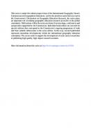
In Brazil, the 1990s was marked by the consolidation of a number of education evaluation systems, when countless initiatives were introduced to establishment powerful and efficient evaluation systems for all teaching levels and modalities. The systems created during this period include the National Basic Education Assessment System (SAEB—Sistema Nacional de Avaliação da Educação Básica), the National High School Examination (ENEM—Exame Nacional do Ensino Médio), the National Course Examination (ENC—Exame Nacional de Cursos), which was later substituted by the National Examination for the Assessment of Student Achievement (ENADE—Exame Nacional de Desempenho do Ensino Superior), the National Examination for the Certification of Youths and Adults (ENCCEJA—Exame Nacional de Certificação de Jovens e Adultos), the National Higher Education Evaluation System (SINAES—Sistema Nacional de Avaliação do Ensino Superior), the Brazilian Examination (Prova Brasil), and the Basic Education Development Index (IDEB—Índice de Desenvolvimento da Educação Básica). The systematic evaluation of school textbooks began in 1997 with the National Textbook Programme (PNLD—Programa Nacional do Livro Didático), which aimed to improve the quality of the country’s education, as well as to consolidate the proposal of the PCNs. For almost 20 years, the PCNs were the basis of the structure of the curricula of the Brazilian states and, in turn, the public selection processes used to recruit the textbook evaluation teams, and define norms and elimination criteria. As part of this programme, the federal government provides schools with textbooks for all the basic education stages (EFI, EFII and EM). These books are distributed to all public school students all around the country. However, the content of the textbooks does not always resonate with the evaluation systems, which is a serious and complex problem. Added to this, the inequalities in the access to school knowledge between public and private school students and, in turn, their progress to higher education, was an ever-expanding problem (Guimarães, 2005; Libâneo, 2016; Saviani, 2008). Private schools adapted more rapidly to the evaluation systems by redesigning their curricula based on the national evaluations. It was soon apparent that the lack of a national curriculum would further deepen the inequalities in the access to knowledge, given that not all students were ensured a curriculum that guaranteed them de facto access to teaching of quality, equity, and the development of basic geographic skills, such as reading and interpreting representations of socio-economic and environmental phenomena. The BNCC is a highpoint in Brazilian regulatory education policy, providing a working document for a country that aims to preserve regional and local heterogeneity as well as to minimise national inequalities in order to ensure equity. Given this, a political pact was sealed between the different political entities, in the quest for equality and solidarity through the democratic preservation of the specificity of each place, while also ensuring a single identity for the document compiled by the states and municipalities. The BNCC defines the essential learning that all students must acquire during their basic education, both progressively and by area (Languages, Mathematics, Natural Sciences, and Human Sciences). The national curriculum is structured in ten general competencies (Fig. 1) that all students must achieve over the course of their basic
For a Powerful Geography in the Brazilian National Curriculum
19
Fig. 1 General competencies in the BNCC. Created by the authors
education (Brasil, 2018). These general competencies are aligned, developed and reinforced according to the specific competencies of each area of knowledge, and the curricular components, which provide the framework for the organisation of state and municipal curricula. The structuring of the national curriculum in competencies and abilities is not a new idea in Brazil, in fact, this approach was established in the National Curriculum Parameters (PCNs) in the 1990s. Like the BNCC, the PCNs have general competencies for basic education, and specific ones for the different areas of knowledge. Overall, the PCNs had five general competencies and nine specific ones. Geography was structured in 45 skills in the EFII (years 6–9). In the BNCC, there are 10 general competencies and seven specific ones, with Geography being structured in 67 skills in the EFII. The BNCC offers a more integrated dimension for the organisation of knowledge, combining the development of citizenship with methodological aspects and the knowledge necessary for self-development. This integration is ensured by the broader project of general and specific competencies (Machado, 2002, 2004; Macedo, 2005a, b). There were conflicting viewpoints among the groups that participated in the formulation of the BNCC due to the variation in the understanding of the concept of competency, a semantic universe that sustains the discourse on education policies. As the focus was on learning, it was necessary to ensure that the younger generation
20
S. M. V. Castellar et al.
would learn through the stimulation of their reasoning, by helping them to understand concepts, to argue, to solve problems, and to raise hypotheses. In this context, we decided (as one of authors of the Brazilian National Basic Curriculum) to ensure the position of the thematic units as the centre of the curriculum by generalising the specific competencies. From this perspective, it is possible to understand that the concept is not neutral, but rather, feeds the discourse in the education sector and knowledge in society in general (Sacristán, 2011; Santomé, 2011; Perez Gomez, 2011). The BNCC considers the general competencies to be reference points. In basic education, Geography also contributes to the development of socio-cognitive, affective and ludic abilities in the student. These abilities are capable of improving the senses and experiences of the student based on their knowledge about the person, the social world and nature. From this perspective, geographic education contributes to the reinforcement of the student’s capacity to participate in the social world, rather than simply reflecting on social, ethical and political issues. All these different components help to consolidate the education of the students and to develop their intellectual autonomy, which is the basis for critical action guided by democratic values (Pereira, 2018; Castellar, 2017, 2019, 2020; Castellar & De Paula, 2020).
Geographic Reasoning Constructed on Real Situations The epistemological statute of Geography comprises a series of structuring categories and concepts characterised by a number of epistemological and ontological approaches that have been developed since the nineteenth century. The principal theorists here include. Humboldt (1848), Ritter (1974), Reclus (2015), Brunhes (1962), de La Blache (2002), Hartshorne (1978), Wright (1947), Sorre (1967), Dardel (1990), Sauer (2000), Lacoste (1985), Santos (1996), Claval (2014), Ratzel (1988), Raffestin (1993), Harvey (1969), Yi-Fu-Tuan (1980), and Massey (2005).4 These thinkers produced analytical theories on a world in which industrialisation and modernisation were on the rise, and capitalism was in metamorphosis. In this scenario, locations are changed, and bodies and lives are controlled and act in response to a moving world, to place and the totality (Santos, 1996). These studies are part of the tradition of geographic thought, and they evaluate where this thought is going (Moreira, 2007). Geographic education depends on this analytical quality to prove its social function. Different concepts of geographic space arise from the different epistemic cores, viewpoints and political influences that came into play throughout the history of Geography. The view of the space, for example, may be a structure, the object of planning and organisation, a product, means, milieu, ecumene, perception of expression. Santos (1996) and Moreira (2009) understand geographic space as being made 4
For further references, see Moreira (2013), Para onde vai o pensamento geográfico? (Where is geographical thinking going?).
For a Powerful Geography in the Brazilian National Curriculum
21
Fig. 2 The geographic knowledge pyramid of the BNCC. Created by the authors
up of an inseparable, supportive and contradictory set of objects and action systems that serve as the basis for the BNCC perspective. Therefore, the Epistemological Status of Geography is made of a set of principles, categories and methodological approaches that have been used throughout the history of the discipline. The Epistemological Status involves constructing an intellectual system that allows analytical thought to approach empirical reality. By studying Geography, we expect students to be able to read and understand reality in spatial terms, perceiving the space in which we live and its relationship with other spaces, derived from geographic situations (Silveira, 1999; Santos, 1996) according to the five thematic units present in the BNCC Geographic Knowledge Pyramid (Fig. 2). The BNCC Geographic Knowledge Pyramid (Fig. 2) has four lateral edges, which form the faces of the pyramid. In this representation, the pyramid comprehends geographic categories and concepts, spatial concepts, geographic principles (location, extension, connection, causality, analogy, differentiation, distribution, arrangement, and order), and cartographic representations. This set of edges structure the pyramid vertex, i.e., geographic reasoning. However, it is only possible to practice geographic reasoning because the geographic situation lies in the base of the pyramid. The geographic situation is formed during the learning process through the dynamics of reality. Reality is reflected in the geographic situation and, through this set of processes, geographic education introduces the world to the student. The contents studied in Geography are the objects of knowledge derived from the arrangement of the geographic situation, the cartographic and graphic concepts, and the representations that reflect geographic categories and principles. The synthesis of these elements makes up a set of knowledge groups that are essential for the teacher in the classroom, to help them stimulate and build geographic reasoning (Castellar and
22
S. M. V. Castellar et al.
De Paula, in press). The objects of knowledge, prepared by the cognitive processes, develop the thematic units in Geography, which are not hierarchical—the movement between them considers reality, the facts, and the learning processes. Geographic education thus has an epistemological statute that is structured by the pyramid’s edges, base and vertex. All and any study of geographic space—which is the basic objective of Geography—is achieved through an intense symbiosis of the processes that consider the episteme of science, the principles of geographic reasoning, and the thematic units. The geographic situation is not only a distinctive territory, but also a continuous area of land, on which a set of relationships is established (Silveira, 1999). The geographic situation permits the understanding of any specific event derived from reality (see Fig. 2), from the interactions between the object and the action systems (Santos, 1996). It thus encourages the elaboration and re-elaboration of knowledge through the application of key concepts that aim to discuss geographic situations. The construction of geographic knowledge is necessary to understand a geographic situation. This can be achieved through the application of geographic principles, categories, and concepts, and cartographic language. As Lacoste (1976) put it—we go to school to learn to read and write, as well as to learn to read maps. A geographic situation about floods or rapid flooding, for example, can guide the student to understand a place, the relations existing within a territory, the changes that happen in the landscape and the different perspectives of scale that make up a region. To do so, it is necessary to educate the eyes, lead them to and raise their awareness of social issues, compare places, understand the extension of an event, and identify its impacts. In order to read the reality based on a geographic situation, it is necessary to develop a geographic vocabulary and reasoning (a method to interpret the phenomenon), to be able to explain and reason about the phenomenon and to overcome the dichotomy of physical and human geography. By understanding the dynamics of reality, the student becomes able to answer why things are where they are and how they are what they are. This geographic situation can be framed in a map or satellite image that shows the location of the affected areas, the magnitude and extension of the event, and the connections that can be observed, described, analysed, compared, distinguished, and evaluated in accordance with the geographic principles applied to the specific case. When students appropriate geographic contents in a meaningful and logic way, they begin to integrate the geographic situation with facts in their own personal contexts, by arranging and acting consciously on them, by proposing actions that enable the relationship between the contents to solve the problems present in the geographic situation, and by developing their critical, reasoning and autonomous capacities. As a consequence, school Geography is empowered by a curriculum that focuses on the geographic situation, which demands the understanding of reality through the epistemological statute of Geography as a science (Young, 2009, 2011; Young & Lambert, 2014).
For a Powerful Geography in the Brazilian National Curriculum
23
Geography in the Brazilian Common Core Curriculum It is worth noting that the principal concern of the BNCC is to organise conceptual systems and themes in such a way as to ensure the learning possibilities of each student at school. This approach changed the way Geography teaching was perceived in Brazil, insofar as we considered endorsing the suppression of the physical and human dichotomy to construct geographic reasoning. As it is acquired by the students, knowledge becomes meaningful and applicable to the analysis of different interpretations of the world. One aspect of Geography in the BNCC that we would like to highlight further is the focus on student learning, which changes the whole meaning of teaching Geography as understood in Brazil up until that moment. When the focus is on learning, to ensure the process of building geographic reasoning, knowledge becomes powerful because it is acquired by the student. After this change was introduced into the curriculum, learning is now promoted in accordance with the abilities related to the specific competencies, where the contents and objects of knowledge are defined. Geographic education is, therefore, guided by the idea of enhancing student learning by stimulating spatial thought as a means of developing geographic reasoning (Pereira, 2018; Castellar, 2017, 2018, 2020; Ascenção & Valadão, 2014; Duarte, 2018). To understand school Geography, it is necessary to reflect on the meaning of geographic science and connect it to life. We aim to reveal specific aspects of the content and show how, why, what for and to whom Geography must be taught. One objective to be achieved is the understanding of the spatiality of phenomena from technical objects, and their function in this location. This means promoting geographic analyses that permit the unravelling of the causes of events or phenomena on the basis of their locational attributes, that is, to understand that objects and actions are as they are, and where they are (Moreira, 2007; Santos, 1985, 1996, 2017; Lacoste, 1976). From this perspective, the abilities contribute to the teaching–learning process, as observed in the following example: BNCC Ability EF07GE02 (7th grade)—To analyse the influence of economic and population flows on Brazilian socioeconomic and territorial development by understanding historical and contemporaneous conflicts and tensions.
For the student to be able to develop an analysis of the influence of economic and population flows in Brazil by using the knowledge generated by BNCC Ability EF07GE02, they must be able connect the objects of knowledge that are intrinsic to it. The objects of knowledge relative to this ability are the characteristics of the Brazilian population in terms of the historical, geographic, social and economic processes that marked the use of the territory. As a result, the study of the ability requires the identification of the different processes and uses of the territory during the formation of the Brazilian socio-economic reality. The student will need to locate the geographic situation during a lesson that may begin by analysing the regional scale and then, advancing to the national scale.
24
S. M. V. Castellar et al.
The development of this ability will make it possible to compare—make an analogy between—the incidence of population flows and migration processes in the different regions of Brazil. The guiding questions may be: Why are population flows larger towards the Brazilian southeast? What explains the high concentration of the population in the southeast region? Which conflicts related to immigration influenced and/or are still present in Brazil? Where are they? How large is the recent geographic phenomenon of immigration in Brazil? Who are the new immigrants? How do they live? Where do they live? Which social, economic and cultural impacts produced by migration is it possible to identify in Brazil? How different are the recent migrations from those at the beginning of the twentieth century? How are they different geographically? These are just some of the questions that may support a debate on the contents of this ability, given that they satisfy the principles of geographic reasoning. The development of BNCC ability EF07GE02, which is a subject requirement for the 7th grade, is characterised by the progression of learning on both the content and the cognitive dimension. For the student to analyse the influence of economic and population flows in the socio-economic and territorial development of Brazil, the student must have studied related abilities in the 6th grade, such as EF06GE01—To compare landscape change and the different uses of the place inhabited at different times. The student can thus understand the changes on the basis of historical processes and human actions. Progressive learning through the accumulation of abilities occurs not only at the level of content understanding (the place, city, region, Brazil, in which the student lives), but in particular at the cognitive level, by comparing, explaining and then, analysing. Just as the previous grade’s abilities are a pre-requisite for those of the 7th grade, the latter are in turn the basis for the understanding of more complex levels in the 8th grade. There is a close relationship between the objects of knowledge and these abilities. For example, ability EF07GE02 is necessary to understand ability EF08GE04—To understand the migration flows in Latin America—voluntary and involuntary movements as well as pull-and-push factors and areas—and the main migration policies in the region. Figure 3 shows the set of processes for the development of geographic knowledge by means of the epistemological statute. Those processes are implied in the study of an ability that involves scientific learning and curricular components, the development of specific and general competencies, the involvement with geographic reasoning principles, categories and concepts, and even the relationship between the progression of learning and the prerequisites for other abilities. The development of geographic reasoning is cultivated not only by the principles of analogy, connection, differentiation, distribution, extension, location and order, but also by the geographic thinking categories and concepts, such as place, territory, region, nature, landscape, everyday life and scales that promote the understanding of geographic space and are associated with cartographic language (Pereira, 2018; Castellar, 2018, 2019). When we structured the BNCC in Geography by preserving the epistemological statute, it was also important to give school cartography a relevant role. We thus included cartography and the inseparable representations of Geography in the statute. The Geography presented in the BNCC expects the students to be able to analyse
For a Powerful Geography in the Brazilian National Curriculum
25
Fig. 3 Example of a 7th grade ability in the BNCC (EF07GE02). Created by the authors
socio-spatial contents while registering places, and naming points and areas in spatial planes (Ascenção & Valadão, 2014; Duarte, 2018). For geographic reasoning, it is sine qua non to be able to develop knowledge through the use of tools such as maps, photographs, videos, illustrations, tables, cartograms, anamorphosis and satellite images, which are the elements that enable the construction of inferences, propositions and arguments. Cartography is not only a thematic unit, but it can also be seen as a transverse theme because its content is inextricably linked to the objects of knowledge of Geography. Given this, the student will be able to analyse a geographic situation using both a text and a map, as demonstrated in the following example. Here, the transit of oil through the Strait of Malacca, in Asia is studied using thematic maps and satellite images to cultivate the student’s comprehension of the region through the geopolitical, environmental, economic and social dimensions. The scenario will be comprehended on the basis of the area’s location, the distribution of oil reserves, the extension of the geopolitical power of each of the countries in the region, analogies with the Strait of Hormuz, and so on. Once the student has all the information in hand, the will not only be able to understand the concepts, but will also be able to develop spatial thought through the interface between the principles of geographic reasoning and the phenomenon being studied. Why is the Strait of Malacca an important region in oil geopolitics? Connecting geographic knowledge to solve a problem—as analysed through cartographic language and spatial concepts—will enable the understanding of the spatial properties of the phenomenon, ensuring the inextricable link between cartography and the specific contents. According to the BNCC, cartography as a language is procedural in the classroom and, in this sense, a map or any other representation is an important strategy in Geography learning (Castellar, 2018). The understanding of teaching and
26
S. M. V. Castellar et al.
learning strategies provide a mode of thinking that is characteristic of Geography and represents geographic reasoning (Gomes, 2017). Overall, then, Geography at school is a way of thinking that serves a well-defined function, given that this knowledge permits the comprehension of the local reality of the student’s living place. The BNCC considers that the pedagogical dimension is essential for the implementation of Geography teaching, and this is one of the greatest challenges for the teacher: the ability to change the culture of teaching practices in the classroom. This is the reason why we support the idea of a teacher’s intellectual life, founded on a repertoire that is inseparable from the epistemological statute and the didactic methods and strategies. This should be an initial and continuing education process, establishing a collective challenge, especially for university professors. We reaffirm the need for schools to cultivate the capacity of the student to surpass local knowledge by offering them a knowledge set that will make it possible to assimilate other views of the world and understand its nature and contradictions (Stefenon & Castellar, 2020).
The Impact of the BNCC on Academic Research in Brazilian Geography Due to the importance of the publication of the BNCC for Geography education, and the need to understand its impact in academic research, we surveyed the academic papers, dissertations and theses published in Brazil that focused on Geography in the BNCC from a number of different perspectives. In April 2020, we searched for the keywords BNCC and Geografia in Geography journals and other databases on the web platforms of the Coordination for the Improvement of Higher Education Personnel (CAPES—Coordenação de Aperfeiçoamento de Pessoal de Nível Superior), a Brazilian federal agency administered by the Ministry of Education, and the Brazilian Digital Library of Dissertation and Theses (BDTD—Biblioteca Digital Brasileira de Teses e Dissertações), which hold the theses and dissertations published by postgraduate programmes in Brazil. We found 32 publications (Fig. 4), of which, 25 were scientific papers published in journals, while six were master’s dissertations, and one was a doctoral thesis, all published between 2016 and 2020. This analysis highlights the impact of the BNCC on academic research in Brazil. In addition to these studies, at least six Brazilian universities—the University of São Paulo (USP—Universidade de São Paulo), Campinas State University (UNICAMP—Universidade Estadual de Campinas), The Federal University of São Paulo (UNIFESP—Universidade Federal de São Paulo), the Federal Fluminense University (UFF-RJ—Universidade Federal Fluminense), the Federal University of Minas Gerais (UFMG—Universidade Federal de Minas Gerais), and the Federal University of Tocantins (UFT—Universidade Federal do Tocantins)—have established courses in their postgraduate programmes in Geography on themes including spatial thought, school cartography and geographic reasoning.
For a Powerful Geography in the Brazilian National Curriculum
27
12 3
10
2
8 6 1 1
4 2 0
2 2016
3
3
2017
2018
Articles
Dissertations
9
2019
8
2020
Theses
Fig. 4 Brazilian academic production on Geography in the BNCC. Created by the authors
To guarantee that state and municipal governments will develop their curricula based on the BNCC, in 2018 the federal government and the Ministry of Education launched the public notice for the 2019, 2020 and 2021 National Textbook Program (PNLD—Programa Nacional do Livro Didático), and the National Common Core Curriculum for Basic Teacher Education (BNC-Formação—Base Nacional Comum para Formação de Professores da Educação Básica) with a view to ensuring the alignment of the curriculum through the selection of didactic textbooks. These measures have guaranteed the creation of new didactic material and curricula in the Geography teacher education courses that follow the guiding principles of the policies of the national curriculum. From this perspective, we believe that the new Geography curriculum has benefited the geographic community, reinforced Geography teaching at schools, and supporting the emphasis on solid geographic knowledge. We do know, however, that theoretical-methodological disputes persist, given the constant debates on the curriculum. We also believe that it is important to have a national curriculum as federal policy in order to ensure access to knowledge for all students, given the marked socioeconomic and territorial inequalities that already characterise Brazilian society.
Conclusion By proposing a Brazilian national curriculum, we have emphasised the acknowledgement of Geography in society and its role in the lives of the students. This would cultivate their understanding of sustainable development, global environmental issues, the geopolitics of mineral resources, and the dynamics of major urban and financial centres, in addition to other topics and events that would require the student to apply
28
S. M. V. Castellar et al.
appropriate geographic categories and principles in order to understand present-day world dynamics. Given this, the design of Geography in the BNCC attempted to recover the epistemological statute of geographic science with a view to enhancing its participation in the school curriculum and, at the same time, to make it possible for the student to read the world and the reality in which they live, by relating other scales of analysis, and by understanding the dynamics of action and object systems, as well as the different uses of territories (Santos, 1996). In this context, the Geography teacher needs to restore their intellectual life in order to keep updated, to understand the importance of the specific methods and didactic practices used in the school environment by being both mediator and inquirer. From this perspective, the teacher can restore their curiosity while also enhancing their science comprehension. Teachers may thus become an important agent for the capture of internal needs and desires, and their expression in such a way that the world begins to make sense and life can be improved. To this end, it is essential that the teacher is sensitive and has a strong theoretical knowledge base, in order to identify with their work at both personal and scientific levels. Overall, then, we believe that the teacher’s role is essential for Geography to gain further relevance and importance in the school curriculum. A powerful geographic education is based on the development of thoughts and rhetoric as well as reasoning. This process demands argumentative, purposeful and inferential logic—dialectics— as a result of the connections students make when they experience and comprehend the surrounding world. These connections require the use of a specific vocabulary and an increase in geographic knowledge, not only in the curriculum, but also in the lives of the students and in Brazilian society as a whole. Re-contextualising Geography will mean making it stronger, rather than dissociating it from its languages and epistemic nature. This will also highlight the capacity to motivate and involve, by provoking meaningful geographic situations that are connected with the reality of the young students. The objective is that students learn about current issues and can deal with them in an autonomous, creative, strict and, above all, emancipating way in the pursuit of citizenship and social justice. This is because Geography is, first and foremost, a powerful kind of knowledge.
References Ascenção, V. O. R., & Valadão, R. C. (2014). Professor de geografia: entre o estudo do fenômeno e a interpretação da espacialidade do fenômeno. Scripta Nova - Revista Electrónica de Geografía Y Ciencias Sociales. Universidad de Barcelona, Vol. XVIII, núm. 496 (03). Available at: file: ///C:/Users/Carol/Downloads/14965-29277-1-PB.pdf. BRASIL. (1988). Constituição da República Federativa do Brasil. Texto promulgado em 05 de outubro de 1988. Brasília: Senado Federal. Available at: https://www.senado.leg.br/atividade/ const/con1988/con1988_05. https://doi.org/10.1988/CON1988.pdf BRASIL. (1996). Lei de Diretrizes e Bases da Educação Nacional. Lei número 9394, 20 de dezembro de 1996. Available at: https://presrepublica.jusbrasil.com.br/legislacao/109224/lei-de-diretrizese-bases-lei-9394-96
For a Powerful Geography in the Brazilian National Curriculum
29
BRASIL. (2014). Ministério da Educação. Planejando a Próxima Década. Conhecendo as 20 Metas do Plano Nacional de Educação. Ministério da Educação/Secretaria de Articulação com os Sistemas de Ensino (MEC/Sase): Brasília. Available at: http://pne.mec.gov.br/#onepage BRASIL. (2018). Base Nacional Comum Curricular. Versão final. MEC/Secretaria de Educação Básica. Brasília. Available at: http://basenacionalcomum.mec.gov.br Brunhes, J. (1962). Geografía Humana. Barcelona, Editorial Juventud. Castellar, S. M. V. (2018). Cartography, spatial thinking and the study of cities in geographical education. Boletim Paulista de Geografia (Vol. 99, pp. 142–160). Available at: https://www.agb. org.br/publicacoes/index.php/boletim-paulista/article/view/1484 Castellar, S. M. V. (2019). Raciocínio geográfico e a teoria do reconhecimento na formação do professor de geografia. Signos geográficos. Boletim NEPEG de Ensino de Geografia, v. 1. Available at: https://www.revistas.ufg.br/signos/article/view/59197/33478 Castellar, S. M. V. (2017). Cartografia escolar e o pensamento espacial fortalecendo o conhecimento geográfico. Revista Brasileira de Educação em Geografia, Campinas (Vol. 7, n. 13, pp. 207–232). Available at: file: ///C:/Users/Carol/Downloads/494-Texto%20do%20artigo-15681-10-20170814.pdf Castellar, S. M. V., De Paula, I. R. (2020). O papel do pensamento espacial na construção do raciocínio geográfico. Revista Brasileira de Educação em Geografia, Campinas (Vol. 10, n. 19, pp. 294–322). Disponivel em http://www.revistaedugeo.com.br/ojs/index.php/revistaedugeo/art icle/view/922/427 Castellar, S. M. V., Lache, N. M., Rodriguez, A. C., & Lozano, J. F. V. (2020). Raciocínio espacial y cartografia. Íber. Didactica de las Ciencias Sociales, Geografia e Historia. Barcelona, Graó. N. 98. marzo. Claval. P. (2014) Epistemologia da Geografia. Florianópolis: EDUFSC. Dardel, E. (1990) L’Homme et la Terre. Nature de la réalité géographique. Éditions du CTHS (Coll. “CTHS-Format”, n 6), 201 p. Duarte, R. G. (2018). School cartography and spatial thinking of Brazilian students at the end of Junior High School. Boletim Paulista de Geografia (Vol. 99, pp. 142–1600. Available at: https:// www.agb.org.br/publicacoes/index.php/boletim-paulista/article/view/1475 Gomes, P. C. C. (2017). Quadros geográficos: uma forma de ver, uma forma de pensar. Rio de Janeiro: Bertrand Brasil. Guimarães, R. B. (2005). O Enem, as Ciências Humanas e suas Tecnologias. In Exame Nacional do Ensino Médio (Enem): fundamentação teórico-metodológica. INEP. Brasília. Available at: http://portal.inep.gov.br/documents/186968/484421/ENEM++Exame+Nacional+do+Ensino+ M%C3%A9dio+fundamenta%C3%A7%C3%A3o+te%C3%B3rico-metodol%C3%B3gica/449 eea9ed904-4a99-9f98-da804f3c91f5?version=1.1 Hartshorne, R. (1978). Propósito e Natureza da Geografia. São Paulo, HUCITEC/EDUSP, 2a edição Harvey, D. (2016). Condição Pós-Moderna. São Paulo. Edições Loyola. 26ª edição. Harvey, D. (1969). Explanation in geography, Londres, Edward Arnold. Harvey, D. (1973). Social justice and the city. University of Georgia Press. Humboldt, A. V. (1848) Cosmos. Essai d’une description physique du monde, 4 tomos (tr. H.Faye), Gide et J. Baudry Libraires-Editeurs, Paris. Lacoste, Y. (1985). La géographie, ça sert, d’abord, à faire la guerre. La Découverte. Libâneo, J. C. (2016). Políticas educacionais no Brasil: desfiguramento da escola e do conhecimento escolar. Cadernos de Pesquisa (Vol. 46 n. 159 pp. 38–62). Available at: http://www.scielo.br/pdf/ cp/v46n159/1980-5314-cp-46-159-00038.pdf Macedo, L. (2005a). Ensaios pedagógicos: Como construir uma escola para todos? Porto Alegre: Artmed. Macedo, L. (2005b). Competências e habilidades: elementos para uma reflexão pedagógica. In BRASIL. Ministério da Educação. Instituto Nacional de Estudos e Pesquisas Educacionais Anísio Teixeira. Exame Nacional do Ensino Médio (Enem): fundamentação teórico-metodológica. Brasília. Available at: http://portal.inep.gov.br/documents/186968/484421/ENEM++Exame+
30
S. M. V. Castellar et al.
Nacional+do+Ensino+M%C3%A9dio+fundamenta%C3%A7%C3%A3o+te%C3%B3rico-met odol%C3%B3gica/449eea9e-d904-4a99-9f98-da804f3c91f5?version=1.1 Machado, N. J. (2002). Sobre a ideia de competência. In: PERRENOUD, P. et alii—Competências para ensinar no século XXI. Porto Alegre: Artmed. Machado, N. J. (2004). Conhecimento e valor. São Paulo: Moderna. Massey, D. (2005). For space. Sage. Moreira, R. (2007). Pensar e ser em Geografia. São Paulo: Contexto. Moreira, R. (2009). Para onde vai o pensamento geográfico? Por uma epistemologia crítica. 1ª Edição. 2ª Reimpressão. São Paulo: Contexto. Pereira, C. M. R. B. (2018). Um mundo de aproximações geográficas com a obra de Chico Buarque: música, linguagem e pensamento geoespacial. Boletim Paulista de Geografia (Vol. 99, pp. 142– 160). Available at: https://www.agb.org.br/publicacoes/index.php/boletim-paulista/article/view/ 1472 Perez Gomez, A. I. (2011). “Competencias o pensamento práctico” La construcción de los significados de representación y de acción. In J.Gimeno Sacristán (comp). Educar por competência, “qué hay de nuevo” 3ª edição, Madrid, Morata (pp. 59–102). Raffestin, C. (1993). Por uma geografia do poder, São Paulo, Ática. Ratzel, F. (1988). Géographie Politique. Éditions Régionales Européennes. Reclus, E. (2015) O Homem e a Terra. Textos Escolhidos. São Paulo. Intermezzo Editorial. Ritter. C. (1974) Introduction à la géographie générale comparée. Cahiers de Besançon, n. 22. Besançon. Sacristán, J. G. (2011).. Diez tesis sobre la aparente utilidade de las competências em educacion. In J. Gimeno Sacristán (comp). Educar por competência, “qué hay de nuevo” 3ª edição, Madrid, Morata (pp. 15–58). Santomé, J. T. (2011). Obviando el debate sobre la cultura em el sistema educativo: Cómo ser competente sin conocimientos. In J. Gimeno Sacristán (comp). Educar por competência, “qué hay de nuevo” 3ª edição, Madrid, Morata (pp. 143–175). Santos, M. (1985). Espaço e método. São Paulo: Nobel. Santos, M. (1996). A natureza do espaço: técnica e tempo, razão e emoção. 3 Edição. São Paulo: HUCITEC. Santos, M. (2017). Toward an other globalization: From the single thought to universal conscience. Springer. Sauer, C. O. (2000). Geografia cultural. In Corrêa, R. L., Rosendahl, Z. (orgs.) Geografia cultural: um século (1). Rio de Janeiro: EdUERJ (pp. 99–110). Saviani, D. (2008). Política educacional brasileira: limites e perspectivas. Revista de Educação PUC Campinas. Campinas, n. 24 (pp. 7–16), junho. Available at: file:///C:/Users/Carol/Downloads/108-242-1-SM.pdf. Silveira, M. L. (1999). Uma situação geográfica: do método à metodologia. Revista TERRITÓRIO, ano IV, nt1 6, jan./jun. 1999. Available at: http://www.laget.eco.br/territorio/sumario_06.htm. Downloaded in April, 2020. Sorre, M. (1967) El Hombre em la Tierra. Barcelona: Editorial Labor. Stefenon, D. L., & Castellar, S. M. V. (2020). Os pressupostos da avaliação e a produção de currículos na escola: reflexões a partir da geografia. Revista Educação & Pesquisa, São Paulo (Vol. 46). Available at: https://www.scielo.br/pdf/ep/v46/1517-9702-ep-46-e216270.pdf. Downloaded in December, 2020. Tuan, Y. F. (1980). Topofilia: um estudo da percepção, atitudes e valores do meio ambiente. Trad. Lívia de Oliveira. São Paulo: DIFEL. Vidal De La Blache, P. (2002) O Princípio da Geografia Geral. Geographia, n. 6, ano III, 2002 [1896]. Wright, J. K. . (1947). Terrae incognitae: The place of the imagination in Geography. Annals of the Association of American Geographers, 37, 01–15. Young, M. F. D. (2009). Education, globalisation and the “voice of knowledge”. Journal of Education and Work, Special Issue.
For a Powerful Geography in the Brazilian National Curriculum
31
Young, M. F. D. (2011). O futuro da educação em uma sociedade do conhecimento. Revista Brasileira de Educação (Vol. 16, no. 48, set.-dez). Available at: http://www.scielo.br/pdf/rbedu/v16n48/v16 n48a05.pdf Young, M., & Lambert, D. (2014). Knowledge and the future school: Curriculum and social justice. Bloomsbury Academic.
The Challenges Faced by the Re-contextualisation of a National Curriculum in Local Contexts: An Approach Based on the Brazilian Case Daniel Luiz Stefenon
Introduction The task of establishing a national school curriculum that contains the knowledge considered relevant to the children and adolescents that attend school in a given country is a complex undertaking. This complexity arises from the conflicting forces and discords among the different subjects and agencies, which often have contradictory interests. As school curricula are cultural documents, i.e., they have a direct influence on the reproduction and transformation of culture, it is important to realise that, given its selective nature, a curriculum will never represent the whole knowledge, legacy or projects of a given society, but rather, they will act as inventories of cultural reference that reflect the times, spaces and policies that have produced it. The new Brazilian national curriculum (Brasil, 2018),1 which has been implemented in schools throughout the country for the past few years, is typical of this scenario. Since the end of the 1964–1985 civil-military dictatorship in Brazil, successive steps have been taken towards the re-democratisation of the country and the expansion of access to state services, in particular those related to education. The basic national curriculum is intended to ensure that a minimum common syllabus is learned nationwide, as proposed in the federal constitution of 1988 and in the 1996 1 2
BNCC (Base Nacional Curricular Comum—Basis for the National Common Curriculum). LDB (Lei de Diretrizes e Bases da Educação—Law of Education Guidelines and Fundaments).
Professor in Department of Geography and Postgraduation Program in Education at Unicentro. Doctor in Education at University of São Paulo (2017) and Master in Geography at Federal University of Paraná (2009). Member of GEPED (Group of Study and Research in Didatic of Geography) and Group EducartGeo. Leader of the Group Percursos (Pedagogies and Curricula in Geography Teaching). D. L. Stefenon (B) Midwestern Parana State University - Unicentro, Irati, Brazil © The Author(s), under exclusive license to Springer Nature Switzerland AG 2021 S. M. Vanzella Castellar et al. (eds.), Geographical Reasoning and Learning, International Perspectives on Geographical Education, https://doi.org/10.1007/978-3-030-79847-5_3
33
34
D. L. Stefenon
general education act,2 which only began to be implemented in practice in 1998, with the publication of the National Curricular Parameters (PCNs—the acronym in Portuguese). More recently, the national curriculum was referred to as one of the principal objectives of the 2014 National Plan of Education (PNE—the acronym in Portuguese), which established the strategies, goals and deadlines for different features of the Brazilian educational system for the subsequent decade. However, the new Brazilian national curriculum (Brasil, 2018) was launched during an extremely turbulent period in the country’s political history. Since 2013, during ex-President Dilma Roussef’s first term in office, the country had witnessed an escalation of public protests, a controversial impeachment process and the rise of a right-wing political movement with a conservative agenda associated with a segment of the country’s corporate and agribusiness elite, which ultimately aimed at establishing a new order in the Brazilian State. In addition to this conjuncture of political processes, the proposal of a new national curriculum is an extremely complex process, given the enormous social and regional diversity of the country, and of its educational scenarios, which create a wide range of specific demands. This obviously hampers the development of a syllabus that is both valid and relevant to the different contexts in which it is be implemented, ranging from some of the world’s largest metropolises to traditional riverside communities whose main activity is artisanal fishing and communities formed by the descendants of African slaves who farm land that is often squatted. This chapter reflects on the pitfalls, limitations and potentialities that the definition of a national curriculum faces within the varied contexts of a country such as Brazil. The text will first explore the tensions derived from the divergence between the need for a common curriculum and the issue of diversity, following, in particular, the contributions of Bernstein (1990, 1996, 1999), which we believe will support the discussion of the classification and use of the subjects taught at school. Finally, a curriculum for Geography is proposed, which intends to promote universal impartiality in the school system, i.e., a curricular format oriented towards the ample promotion of the rights acquired from the policies of equality and diversity that have been applied to the various educational contexts.
The Brazilian National Curriculum and the Diversity Issue Since the re-democratisation of Brazil, education has been considered to be one of the principal pillars of the country’s development and the elimination of its inherent inequalities. In the context of the establishment of its new democracy, the Brazilian government published a document entitled Education for All, which states that: The greatest commitment of the New Republic, as a response to national aspirations, is the construction of a democracy and the promotion of development with justice. This task demands, most of all, the recuperation of the enormous social gap, which has reached disturbing proportions, and the establishment of new and decisive action by both the State and society itself. Most of all, education must be seen as an essentially democratic act within
The Challenges Faced by the Re-contextualisation …
35
the global perspective of the demands of a democratic society. Basic education is the right of all citizens and the complete responsibility of Brazilian society, which will guarantee its universalisation with the active participation of all its different segments (Brasil, 1985, p. 2).
Mass schooling, i.e., the education of underprivileged individuals with an unfavourable socio-economic background, received core status in the educational debate and policies, although the consensus on “what to do” was invariably greater than “how to do it”. This divergence was so profound that, when the focus turned to educational universalisation, the issue of the quality of the education appears to have been overlooked as a core concern of these initiatives. Based on the ideals of Marxist criticism, the scientific community is intrigued by this context of transformation. The debate persists among two pedagogical movements known as the Critical Pedagogy of Contents and the Popular Education groups, and is a very rich and original source of references and divergences. Basically, the core of the intellectual debate between these movements is how to conceive the knowledge that should be taught at school. For the content pedagogues, a curriculum able to satisfy its social function will be linked to the transmission of knowledge on specialist subjects, which is the ultimate goal of education. To Saviani3 (2000), an important member of this movement, …this is where we have to find the natural sources for the preparation of methods and approaches to the organisation of the set of school activities, i.e., the curriculum. Here, we can recover the all-encompassing concept of curriculum (the organisation of the set of core activities distributed in the school’s space and time). Therefore, a curriculum is the way a school functionings, in other words, a school performing its proper function. (p. 23).
The popular educators, on the other hand, were influenced by the thinking of Paulo Freire,4 and argued that significantly communicable knowledge is the knowledge that has fundamental ties with the culture shared in the everyday life of the student. The school curriculum should thus be derived from a collective construct based on the principle that the communication process is transmitted from a concrete reality, which arises from the contextual universe in which the student lives (Freire, 1988; Scocuglia, 2005). This debate creates a situation in which the content pedagogues tend to accuse the popular educators of promoting schools that prioritise local features disproportionately, in relation to the immediate context of the student’s life, thus depriving students from underprivileged socio-economic backgrounds access to institutional, erudite and universal knowledge. Popular educators, in turn, accuse their opponents of over-valuing systematised knowledge and the dominant culture, given that they do not problematise the nature of the school subjects and “because they do not question 3
In addition to Demerval Saviani, other important members of this 1980s movement include the researchers Carlos Roberto Cury, José Carlos Libâneo and Guiomar Namo de Mello (Moreira, 2012). 4 Paulo Freire’s ideas continue to influence thinkers and education systems all over the world. However, in Brazil, other contributors, such as Carlos Rodrigues Brandão, Moacir Gadotti, Celso de Rui Beisiegel and Lisete Arelaro have also been important figures in the systematisation and divulgation of Freire’s thinking (Brandao, 2005).
36
D. L. Stefenon
the actual capacity of the bourgeois school to emancipate socially-disadvantaged children” (Moreira, 2012, p. 142). The debate initiated by the two Brazilian movements appears to represent an embryo of the divergences that followed in the subsequent decades, which introduced important elements of reference for the interpretation of the constitution and the transformation of the Brazilian education system, in particular with regard to the relationship among different types of knowledge presented in the school curriculum. The relationship between everyday knowledge and institutional knowledge, and their respective positions in the process of the construction of the curriculum contribute to the configuration of the so-called common curriculum. Implicit to this debate is the underlying tension between the offer of a universal, systematised curriculum that serves the different groups that make up a society and, on the other hand, establishment of a curricular policy based on the autonomy of the schools, which would be able to select more freely and flexibly the legitimate knowledge to be included in their curricula. The relationship between autonomy and formal order shields an important debate about the inequality of a society and its relationship with the school. In other words: [...] how can anyone not to be morally indignant when facing the increasing gap between the rich and the poor, witnessing the persistence of hunger and the lack of a place to live, the fatal absence of medical assistance, the degradation of poverty? Were these the core themes (with self-criticism and constant subjectivation) of a national school curriculum—but, then, how could it be tested efficiently at low cost, and how could the Right Wing control its means and purposes? … maybe such a curriculum would even be worthwhile (Apple 2011, p. 102).
By highlighting the contradictions inherent to a proposal for a common national school curriculum, Michael Apple reveals the need to question the thinking of an educational process that offers schooling to everyone, but may not be able to fulfil their social realisation and inclusion. By focusing on the ideological component in the process of formulating the curriculum, Apple author draws our attention to the political aspects of the definition of what counts as legitimate knowledge, by taking the process of the selection of content from the technical level to the arena of political disputes. In this context, the struggle over educational inequalities would be linked directly to the ideological assumptions that guide the formulation of the curriculum. This warning (Apple, 2011) is associated with the equally important scenario of the divergences within the curricular field, expressed by the debate on the role of the school and institutional knowledge in the current historical–geographical context. In a way, we can argue that the concepts on the role of the school are a proxy for the non-consensual debate over the school curriculum. However, other thinkers have offered a more contained viewpoint on the potentialities of the transformations in the school system, in particular, the reproductivists of the 1960s and 1970s, in addition to the so-called post-modern educators, as highlighted by Young (2007). To Young, the reproductivists believe in the “idea that the school’s primordial role in capitalist societies was that of teaching workers where their place was” (Young, 2007, p. 1289). Furthermore, the basic function of school, from the perspective of intellectuals such as Althusser, Bourdieu, Bowles and Gintis, and Willis, was merely to reproduce the
The Challenges Faced by the Re-contextualisation …
37
unequal relationships of the social classes, without ever demonstrating its potential as an institution of social transformation. On the other hand, the epistemological stance of the post-modern intellectuals supports the criticism of the potential of institutionalised, syllabus-based school knowledge. As an example, …in his book Discipline and Punish, Foucault (1995) grouped schools together with hospitals, prisons and asylums, considering them institutions of surveillance and control, which would discipline students and organize knowledge in the format of school subjects. [...] For Foucault, there was no alternative for seeing schooling as surveillance, and the only thing social scientists and educational researchers could do was to criticise. (Young 2007, p. 1290).
By questioning the rigid time and spaces of the school, then, the post-modern paradigm points to the valuation of a pact for schools that construct their knowledge based primarily on the everyday life of the student. In other words, school faces the issue of the diversity by promoting the development of competencies defined by the context in which its students live their lives. However, a pure and radical stance from this perspective would tend to overlook other important factors that determine the communicative potential of the school in the education process. This reflects an alternative concept of school, which can be summarised in the idea that it should …organise the radical development of its function of compensating for inequalities of origin by heeding and respecting diversity [...] and trigger and facilitate the reconstruction of knowledge, of the mechanisms and models of conduct that a child assimilates in their parallel life previous to school. As Wood (1984, p. 239) put it, to prepare students to think critically and act democratically in a non-democratic society (Pérez Gómez, 1998, p. 22).
In agreement with Bernstein, Young (2007) goes even further, and criticises the weakening of the borders between school and non-school learning in an attempt to justify a curriculum that is more accessible to the varied groups attending the school. Young goes on to say that, as the borders blur, the school curriculum subsides, and may create conditions that deny a certain type of knowledge to students from an underprivileged socio-economic background, in particular the knowledge that would provide them with the capacity to question life-limiting contingencies and promote change. From Young’s perspective, this type of curriculum challenges the principle of impartiality in a school whose primary task should be to offer students what he calls powerful knowledge. In his words: “In using the very general word “knowledge”, I find it useful to distinguish between two ideas—“knowledge of the powerful” and “powerful knowledge”. “Knowledge of the powerful” refers to those who define “what counts as knowledge” and have access to it. Historically and even today, when we look at the distribution of access to university, it is those in society with more power who have more access to certain kinds of knowledge. It is this that I refer to as “knowledge of the powerful”. [...]We therefore need another concept to conceptualise the curriculum that I want to refer to as “powerful knowledge”. This refers not to who has most access to the knowledge or who gives it legitimacy, although both are important issues, it refers to what the knowledge can do—for example, whether it provides reliable explanations or new ways of thinking about the world. (Young 2007, p. 1294).”
38
D. L. Stefenon
A certain tension is clear here between the different conceptions of school, which either indicate that it should either be based primarily on the contextual knowledge of the students or it should heed common culture, offering students structured specialist subjects that will provide the students with the tools necessary to place themselves, broadly and actively, in the world, beyond the limits of their own communities. This conflict between paradigms provides an alternative perspective for the evaluation of the knowledge transmitted by schools. If, on the one hand, class inequalities are privileged, the school will need to seek out alternatives to promote curricular equality. On the other hand, the post-modern ideals suggest a school based on the interests and demands of the community, which assimilates the diversity paradigm. Even though domination and ideology are the background to both propositions, underlying the debate, the implementation of the strategies intended to resolve the problems existing in the school are considered from distinct perspectives. The issue of diversity is thus a core topic for consideration in school programmes. There is no adequate educational process without taking into account the reality of those who attend that school, their anguishes and needs, and the basis of their everyday learning and activities. However, the argument presented here assumes that, in its most extreme form, a multicultural curriculum may risk leading the school towards a certain relativism of its social function. As Sacristán (1995) puts it: [...] neither would be realistic, or naive, about an absolute cultural relativism within the school system. All in all, schooling still is a means to provide competence for participation in the dominant social, economic and cultural life, which can always be improved. It is obvious that it is not configured equally for all cultures (Sacristán 1995, p. 106)
In other words, the obsessive quest for the protection and valuation of diversity in the school may eventually become an obstacle to its greater task of offering opportunities to the varied social groups, to ensure them access to certain elements of the institutionalised common culture transformed into curriculum. Santos (2011) proposes that, when contemporaneity is analysed, and new meaning is given to old utopias (rather than suppressing them), advocating simultaneously both the revision and the affirmation of the Utopian Education based on the conviction of its transforming potential. To provide a reference point for the consideration of these questions, some of the propositions of Bernstein’s theory will be presented and discussed below. These points provide new perspectives for the understanding of the interaction between everyday learning and syllabus learning, within the scope of curricular construction.
Bernstein’s Contribution: Contexts, Texts and Communication Codes at School Basil Bernstein’s theory focuses, in general, on the processes of cultural reproduction and transformation, and on how the school institution promotes, through its pedagogical tools, a symbolic control of the social classes, thus defining “who can
The Challenges Faced by the Re-contextualisation …
39
learn and what can be learned” in each educational context. The school curriculum, in particular the national curriculum, thus plays a fundamental role in this process by acting directly on the types of discourse and the cultural dimensions that will be offered and reproduced for the subjects located at different points on the spectrum of social relationships. Bernstein sees two principal categories of knowledge circulating in the school environment: Vertical Discourses (VDs) and Horizontal Discourses, or HDs (Bernstein, 1999). The HD is linked directly to common sense and everyday knowledge and, as such, it is characterised by orality and local insertion. This is to say that the meanings contained in the HD will depend directly on the context in which they are enunciated. To understand the meaning of a discourse, the subjects involved must understand or be initiated in the specific contexts, given that the meaning of the words, gestures and other reactions will tend to refer to everyday activities at a local scale. The Vertical Discourses, in turn, refer to structured specialist subjects based on explicit standards of coherence. Here, verticality refers to the attribution of references to facts or other enunciations accepted conventionally, which links the discourse to the world of scientific research and specialist knowledge. Here, then, the meaning of the discourse does not depend on its context, but rather, on generalisations of known and explicit criteria applied according to methods of a universal and systematic nature (Bernstein, 1999; Morais & Neves, 2007). Whereas horizontal discourses are learned based on the everyday experiences of the subject, then, vertical discourses require a systematic pedagogy, which is able to reproduce rules and models that will be the base of their legitimacy and the validity of their enunciations in the communication process. At this level, the school plays the fundamental role of offering the tools that enable the students to acquire the rules they need to understand and manipulate this type of knowledge. In general, no other contemporary institution is capable of realising this task as systematically and efficiently as a school. The set of rules that substantiate discourses, whether specialist or otherwise, whether learned at school or in everyday experience, are called communication codes by Bernstein (1990, 1996). In this sense, a code is a principle that regulates the relationships of communication among the members of a certain class or social group within different communicative contexts, and provides coherence to the texts produced within these contexts (Bernstein, 1990, 1996). While horizontal discourses predominate in the context of everyday life (here known as restricted codes), in the context of institutionalised life—which includes school rites, working practices and vertical discourses—the codes (elaborated codes) guide the construction of texts. In other words: In the restricted orientation, meanings are particularistic, they depend on the context and have a direct relationship with a specific material base. In the elaborated orientation, meanings are universalist, relatively independent from the context and have an indirect relationship with a specific material base (Bernstein, 1996, p. 116).
40
D. L. Stefenon
A code thus presupposes the sharing of common references that will enable communication in specific cultural environments and contexts, and “that is why it is not possible to discuss code referring to cognitive/linguistic shortcomings at the competence level” (Bernstein, 1996, p. 159). In this case, the elaborated codes are not simply “more elaborated” than the restricted codes, but rather, they stand for a format of communicative grammar with a universal basis, and a specialised function that does not correspond to the context of a restricted code. Bernstein thus suggests that it is not possible to treat one code as more sophisticated or deficient than the other, but rather that an unequal distribution of the knowledge provided by elaborated codes—which is typical of schools—is a factor that contributes to the reproduction of educational inequalities. In this context, a national curriculum has the potential to establish references for the acquisition of language codes by the students that allows them to transit between different contexts of communication. As the students are able to acquire the restricted codes in the context of their everyday interactions with family members, friends and primary levels of socialisation, the school is responsible for providing a knowledge set that will broaden significantly the level of performance of these individuals. The texts produced based on either restricted or elaborated codes will thus collaborate mutually to ensure the communicative competence of the individual, that is, their handling of different communication contexts. By being able to understand the content of communication in varying social contexts, students will be able to exercise their autonomy more effectively, promoting stances and practices that obey the contradictions encountered both in their daily lives (immediate context) and in broader areas of society.
The Policies of Equality and Diversity, and the Brazilian National School Curriculum Schools and their curricula are complex territories, loaded with their own particular tensions and contradictions. This is why the concept of justice in school tends to encompass an ample set of rights. The rights which the school needs to guarantee—in particular the institutions attended by students with an underprivileged low socio-economic background—are related to policies of both equality and diversity. This means that the school faces a dual set of demands, which, on the one hand, aim to guarantee access to the knowledge necessary for existence in a given society, while at the same time guaranteeing respect and the valuation of the diverse identities that compose this society. In other words, the school has to cope with the idea that: “we are entitled to be equal whenever the difference makes us inferior”, while also admitting that the students “are entitled to be different whenever equality de-characterises [them]” (Santos, 1999, p. 61). However, disputes for political and academic hegemony often lead to a situation where borders are drawn up between stakeholders and agencies that restrict dialogue
The Challenges Faced by the Re-contextualisation …
41
and the potential cooperation between the different viewpoints. As these positions deepen and become more specialised, in particular in the context of the production of knowledge by the school, equality and diversity tend to mutually annihilate each other on the table of the debate. The eagerness of the particularists to establish symbolic control on the goals and social functions of the school reveals the most perverse face of the lack of dialogue within the academic environment. Fraser (2006), who draws on the propositions of Santos (1999), approaches this issue based on the perspective of redistribution and recognition, which can be linked to injustices related to policies of equality and diversity, respectively. We thus agree with the author’s criticism when she argues that: [...] today justice demands both redistribution and recognition. I propose examining the relationship between them. This means, in part, to think of how to conceptualise cultural recognition and social equality in ways that are able to support each other, rather than annihilating each other (given that there are so many concurrent conceptions of both!). This also means theorising about the means through which economic deprivation and cultural disrespect simultaneously intertwine and support each other. It thus also requires clarifying the political dilemmas that arise when we try to fight these two injustices at the same time (Fraser, 2006, p. 231).
Reconnecting redistribution (equality) and recognition (diversity) thus becomes an important consideration for the construction of both official curricula and the curriculum actually used at a school. From a methodological standpoint, Young (2011) offers an interesting alternative. When saying that educational practice is composed of the dimensions of both the curriculum and pedagogy, he highlights that the former [...] refers to the knowledge a country thinks important to be within the reach of all students. The second idea is about pedagogy, which, by contrast, refers to the attempts of the teachers to motivate students, and to help them engage with the curriculum and to make it significant (Young, 2011, p. 612).
By differentiating these two dimensions that determine the teacher’s practices, Young (2011) points out that official curricula, which are generally not the direct product of the participation of teachers, represent a common reference that can guarantee access to basic learning rights regardless of the regional or socio-economic background of the students. This would contribute to redistribution. By contrast, the pedagogy dimension corresponds to an area in which the teachers are able to exercise their autonomy broadly and unrestrictedly. The effective implementation of the official curriculum and the learning rights of the students will depend directly on teachers recognising and listening attentively to what their students are saying, their demands, anguishes and the knowledge they bring to the classroom, the sum of which is the basis of the conceptual reconstruction during class work. When Young’s (2011) proposal, based on Bernstein’s (1990, 1996) references is considered critically, it is possible to perceive that, rather than merely transmitting official knowledge and teaching subjects, the exercise of a teacher’s pedagogical autonomy also contributes to the construction of the curriculum. Clearly, the knowledge inserted in the official curriculum is re-contextualised by the teachers, i.e., it is
42
D. L. Stefenon
re-focused when removed from the context of its production and inserted in the school context. This is to say that, as proposed by Bernstein (1996), the primary context of the socialisation of the students contributes directly to the configuration of the school curriculum, with the social origin and cultural identity of the students being stressed when shaping the expectations of should be learned at school. Even when considering the interdependence between the curriculum and pedagogy dimensions in the school, it can be understood implicitly that their differentiation can provide a valuable tool for organising the work of the teachers and delimiting the rights that the teacher needs to respect. Obviously, the complexity of the factors that shape the reality of the school also influences the way Geography is taught and learnt. To ensure the dialogue of the ideas and assumptions presented here, the principles and stances most relevant to the policies of equality and diversity in the school Geography curriculum are presented below. Once again, it is important to remember the duality of the redistribution of resources and access to the world and the recognition of the identity and origin of the students.
The Principles and Stances of School Geography in the Context of Inequality and Diversity School curricula establish trajectories in which students will have specific experiences guided by varying formats of discourse. A curriculum can be understood as “a set of knowledge and competences, of institutions, values and symbols composed over generations and characteristic of a particular human community, defined in a more or less broad and more or less exclusive way” (Forquin, 1993, p. 12). When considering the curriculum as a pedagogical discourse, Bernstein (1990, 1996) proposed a distinction between the official curriculum—or official pedagogical discourse—and the curriculum that is actually used at a school, which he referred to as the pedagogical discourse of reproduction. These two types of discourse are produced by successive phases of didactic re-contextualisation, that is, by removing specialist subjects from their contexts in which they were produced and relocating and re-focusing them in new contexts. Didactical re-contextualisation is thus a process that aims to embed an instructional discourse—the learning of specialist subjects— within a regulative discourse, i.e., in texts that have formative intentions and those that regulate students’ behaviours and stances. Given this, the agencies of the so-called official re-contextualisation field and the teachers in their field of pedagogical re-contextualisation within the scope of the school environment together establish principles and make choices that interfere in the way that specialist subjects, regulative discourses and everyday knowledge will be included in the curricular text. The re-contextualisation process is thus a mechanism of symbolic control—over who should learn and what should be learnt—which
The Challenges Faced by the Re-contextualisation …
43
affects the distribution of the different kinds of awareness among the individuals that make up a society. Considering the principles and stances of School Geography that aim to take into account the typical complexity of the student body, an official curriculum must be capable of (a) establishing references that minimize inequalities in the access to knowledge; and (b) allowing teachers the autonomy to recognise and value local specificities and the diversity that determines them. Based on the assumptions presented here, the format of a curriculum can be obtained by observing elements such as (i) the preservation of teacher autonomy for the construction of the curriculum and pedagogy at the school; (ii) the valuation of the contexts of primary socialisation when selecting themes and problems in the classroom; (iii) making learning rhythms (pacing) flexible; (iv) differentiating between scientific knowledge and everyday knowledge when organising the curriculum, and (v) free movement among the different geographic scales of analysis. The first of these principles (i) the preservation of teacher autonomy for the construction of the curriculum and pedagogy at the school, highlights the role of the teacher in the handling and management of the different aspects of the pedagogical activity, composed of instructional and regulative discourses, spaces, times and primary socialisation contexts, for example (Stefenon, 2017). It is thus necessary to reiterate that the elaboration of relevant and significant educational practices will depend directly on the teacher’s conscious selection of curricular components and pedagogy that will convey these different components to the classroom. In this context, the quality of a teachers’ qualifications, in terms of both their basic training and their professional activities is fundamental to the quality of the learning experience offered to the students. A new school, which may be more attentive to the question of inequality and diversity, needs to pay special attention to these questions, not only in terms of the professional qualifications the teachers, but also to the implementation of development programmes, and the recognition and valuation of their staff. These considerations are obviously related to elements such as fair salary policies, adequate working conditions and infrastructure, and a workload compatible with healthy professional and personal lives, which are vital to guarantee the best performance of the teachers. Experiences lived outside the school and the social origins that influence the History and Geography of the students attending the school emphasise the need for the valuation of the contexts of primary socialisation when selecting themes and problems in the classroom (ii) This reflects an important aspect of the school reality, and influences the characteristics of the curriculum implemented at the school. A number previous studies (e.g., Bourdieu & Passeron, 2014; Coleman, 1966) have drawn attention to the fact that the structure of a society plays a core role in the successes and failures of a school. These studies also stress the limited power of school institutions per se to change society. Inevitably the school ends up reproducing external conditions, i.e., segregation, inequality and exclusion, and is transformed into a promoter of “symbolic violence”.
44
D. L. Stefenon
The position of Bernstein (1990, 1996), in turn, seeks to incorporate and promote the analysis conducted by Bourdieu, in particular because he considers that the opinions of this author focus on “describing the carrier only with a diagnostic of its pathology” (Bernstein, 1996, p. 238). Bernstein proposes, furthermore, that he wants “to understand how external power relations are conveyed to the [educational] system” (idem, ibidem), thus promoting the “symbolic control” of the social classes. In this case, the context of primary socialisation, which is related to family environments and other spaces of everyday life, is treated as an element of the pedagogical game rather than a random factor. In general, then, Bernstein sees education systems as being ingrained with the diversity and inequalities of their students, and thus in need of organising their spaces, times and curricular experiences by prioritising (iii) making the rhythms (pacing) of the educational practice more flexible. This initiative tends to establish a path of learning that is more attentive to individual differences and demands, which is essential for full access to the elaborated communication codes, which are not available to all the students coming from different backgrounds of primary socialisation. From this perspective, Geography, in addition to being a component present of the school curriculum, also has an ample potential to contribute to its formulation by providing input on these varying backgrounds. Social cartography (Gomes, 2017), mental maps (Kozel, 2018), and other environmental studies (Lopes & Pontuschka, 2010) provide pedagogical and diagnostic tools that can provide important parameters for the school and for the Geography teacher to build meaning into their performance, based on adequate pacing for different students. The fourth principle proposed here (iv) differentiating between scientific knowledge and everyday knowledge when organising the curriculum. The school, while a privileged environment of symbolic exchange and a place of encounter and exchange among different types of discourse, plays a double role of reproducer and creator of culture. By observing, in particular the Geography taught at a school, we can observe the representations acquired by the students with regard to places, human groups and different natural and social phenomena. In addition to providing important resources for production in classroom, these representations also express a set of diversities that bring their spaces to life. By acknowledging and defining the roles of the different types of syllabus and understanding how to exploit them in the classroom, teachers are able to contextualise meanings on the themes and contents of the curriculum, which thus become more accessible to the students. This argument is related directly to Young’s (2007, 2011) proposals on the need to differentiate the types of discourse and kinds of knowledge circulating in the classroom. To Young, understanding the nature of the discourse and ensuring access to specialist subjects is a condition for the acquisition of powerful knowledge, i.e., the knowledge with potential to promote cognitive change in the individual and to provide the students with the autonomy to think and act critically, regardless of their background. It is important here to redeem the idea that scientific knowledge is “better” or “more appropriate” than everyday knowledge. On the contrary, according to Bernstein (1990, 1996), it is clear that what sets them apart is the system of the production
The Challenges Faced by the Re-contextualisation …
45
of meanings in the texts in the different discourses, and of the codes that regulate them. They may acquire validity depending on the different communication contexts and legitimation systems. In other words, these differences are intrinsic to their production and the uses for which they are destined. This means that, as mentioned above, learning science does not exclude the knowledge acquired in everyday life (horizontal discourse), nor does personal experience prevent learning science (vertical discourse). Every student should be able to activate specific communication repertoires depending on the moments and situations in their lives. Their intellectual and practical autonomy will depend on their capacity to identify the pertinence of their use in different environments, such as at work, on the street, at school, at home and in social conflicts. Finally, we suggest that a curriculum that is attentive to both the inequalities of access to the world and its diversity must consider the movement among different geographic scales of analysis (v) This movement among scales is an essential element in schooling. While admitting that this is a recurrent theme in the discussion and research in teaching Geography, the insights provided by Bernstein (1996) draw attention to the fact that schooling is essential to the development of full communicative competences, which refer to the aptitude of the student to relate to others, both in the context of their location and also in the broader realm of more formal exchange systems. For this, it is necessary to have ample access to the different communication codes underlying the contexts of the different experiences to which students relate or will relate to in the future. Depending on the position of the individual in the spectrum of social relations, and as a result of this position and the social expectations with regard to their learning needs, the school can place students in symbolic environments oriented more towards the world as a whole or focusing more on the immediate context of their everyday lives. Using the hypothetical example of workers on a sugarcane plantation farm, the author demonstrates that: From the point-of-view of a rural worker, he or she will see himself physically as a part of a simple division of labour and the interactive practices of these people will have its centre of gravity in the interactions within a simple division of labour, which regulates practices in relation to a specific, local material base. However, in the case of the boss, he (and not she, historically) will see himself physically as part of a complex division of labour which includes the total local division of the labour on the farm, the market and the local circulation of capital, and which also includes a complex division of labour on the national and international markets, with their corresponding circulation of capital (Bernstein, 1996, p. 155).
By highlighting these inequalities in the access to the elaborated communication codes—which allow meanings to be understood in the formal and generalised context of communication—and to avoid the depreciation of the expectations on student performances, we support the perspective of a multi-scale curriculum format. This means acknowledging that both what is far and what is near is a prerequisite for a world of totality (Straforini, 2004), which will enable the student to understand space and life more critically and relationally.
46
D. L. Stefenon
Otherwise, an education system that does not intend to confine its students to a restricted symbolic universes must understand that the contradictions affecting them are related to multiple scales of influence. The understanding of the reticular and integrated organisation of this space then becomes an important route for the students to become aware and assume a specific position in the most varied situations affecting their everyday experiences.
Final Notes: On Understanding the World and Oneself The assimilation of local spatial properties provides an important source of reference for school students. Based on the fundaments presented in this chapter, we propose that scientific knowledge does not eliminate everyday life. Quite the opposite, in fact, given that everyday life offers new perspectives on the problems related to the world experienced in a community. It thus seems reasonable to imagine that the formats and assumptions made in the national and official curricula have a direct effect on the way local knowledge will contribute to the classroom. Based on this discussion, the relevance of the curriculum becomes central to the process of selecting its format. Selecting appropriate themes to illustrate theories and connect the student to the world is not a task that can be undertaken solely by curriculum makers. The autonomy of the teacher is also fundamental for the selection of a curriculum, in order to guarantee its relevance, given that it is the teacher who can recognise and mobilise the interest of the students. In other words: Choices might be influenced by what is considered relevant. Relevance can mean different things. Geography could be relevant to the location and country in which students live, to their experiences of these locations and awareness of issues affecting their lives. It could mean relevance to understanding current world issues, such as global warming, sustainability, globalization and sources of energy. […] Relevance could mean that the curriculum relates to student interests (Roberts, 2014, p. 203).
However, based on the proposals discussed here, it is clear that even a relevant curriculum cannot be applied without the operationalisation of concepts and the teaching of specialist subjects. Kaercher (2014), Cavalcanti (1998) and Castellar (2007) all agree that the concepts intrinsic to the body of knowledge of specialist subjects such as Geography should be seen as tools to be used to understand the world and to permit the students to act with awareness and a critical perspective. Despite being the products of formal academic research, the structuring concepts of the science—space, place, territory, region, landscape—and other concepts from the different fields of geographical analysis—e.g., hydrographical basin, culture, morphoclimatic domain, soil erosion, migration—have the potential to broaden the perspective of the students and provide them with alternative ways and scales of viewing their immediate surrounding. National or official curricula, while defining the right of the student to conceptual learning, should not limit the autonomy of the teacher to make specific curricular choices within the scope of the school. This enables teachers to consider the role
The Challenges Faced by the Re-contextualisation …
47
of the official curriculum in a more collaborative way, and to guarantee the balance between learning specialist subjects and acquiring local knowledge. From this perspective, the learning of specialist subjects, in addition to enabling a new and critical viewpoint on the environment in which we conduct our everyday activities, also supports the understanding of the broadness of the world that goes beyond our village (or community), and the various interactions among these different spatial dimensions. Above all, school Geography, which is derived from this approach, expects the student to recognise that the place in which they live is infused in a set of relationships with other places, and that the awareness of who we are depends on our sense of otherness (i.e., accepting the fact that our identity is defined in relation to others), all of which requires the autonomy of thought cultivated by good Geography teachers. Given this, we agree with Dardel (2011, p. 10), to whom “human freedom is affirmed when it eliminates or reduces distances”. That is to say, when people have access to knowledge, they can access the world in all its multiple dimensions. By controlling space or knowledge, the individual acquires an awareness that enables them to find a better position in the world and to act critically on that position. By highlighting the role of Geography in schools and, in particular, its potential to expose the contradictions of the contemporary world, we conclude that it has an important place in the education process, in particular to overcomes the inequalities of power that permeate the contemporary world, and which ultimately threaten the consolidation of a democratic state. In the school context, this confrontation is related to the need to provide powerful knowledge to everyone, without distinguishing their cultural origin or social class. All educators must acknowledge that this is an obligatory task for the full realisation of their social function and for the broad acknowledgement of our potential, as citizens, to transform the world.
References Apple, M. (2011). A política do conhecimento oficial: faz sentido a ideia de um currículo nacional? In A. F. Moreira & T. Tadeu (Eds.), Currículo, cultura e sociedade. Cortez, São Paulo. Bernstein, B. (1990). Class, codes and control. In The structuring of pedagogic discourse (Vol. IV). Routledge, Londres. Bernstein, B. (1996). A estruturação do discurso pedagógico: Classes, Código e Controle. Petrópolis: Vozes. Bernstein, B. (1999). Vertical and horizontal discourse: An essay. British Journal of Sociology of Education, 20(2), 157–173. Bourdieu, P., & Passeron, J. (2014). A reprodução: elementos para uma teoria do sistema de ensino. Petrópolis: Vozes. Brandão, C. R. (2005). Paulo Freire: educar para transformar. São Paulo: Mercado Cultural. Brasil. (1985). Educação para todos. Brasília: MEC. Brasil. (1996). Lei de Diretrizes e Bases da Educação Nacional. N. 9394. Brasília: Presidência da República. Brasil. (1998). Parâmetros Curriculares Nacionais para o Ensino Médio. Brasília: MEC/SEMTEC. Brasil. (2018). Base Nacional Curricular Comum. Brasília: MEC.
48
D. L. Stefenon
Castellar, S. (Ed.). (2007). Educação Geográfica: teorias e práticas docentes. Contexto, São Paulo. Cavalcanti, L. de S. (1998). A Geografia e a construção de conhecimentos. Campinas: Papirus. Coleman, J. (1966). Equality of educational opportunity. Office of Education, U.S. Dardel, E. (2011) O homem e a terra: natureza da realidade geográfica. Perspectiva, São Paulo. Dubet, F. (2008). O que é uma escola justa? A escola das oportunidades. Cortez, São Paulo. Forquin, J.-C. (1993). Escola e Cultura: As bases epistemológicas do conhecimento escolar. Porto Alegre: Artes Médicas. Fraser, N. (2006). Da redistribuição ao reconhecimento? Dilemas da justiça numa era pós-socialista. Cadernos De Campo, 14–15, 231–239. Freire, P. (1988). Pedagogia do oprimido. Paz e Terra. Gomez, M. V. B. (2017). Cartografia Social e Geografia Escolar: Aproximações e possibilidades. Revista Brasileira De Educação Em Geografia., 7(13), 97–110. Kaercher, N. A. (2014). Se a geografia escolar é um pastel de vento o gato come a geografia crítica. Evangraf, Porto Alegre. Kozel. S. (2018). Mapas Mentais: Dialogismos e Representações. Appris, Curitiba. Lopes. C. S., & Pontuschka, N. N. (2010). Estudo do Meio: Fundamentos e Estratégias. Maringá: Eduem. Morais, A. M., & Neves, I. P. (2007) A teoria de Basil Bernstein: alguns aspectos fundamentais. Práxis Educativa, 2(2). Ponta Grossa: UEPG. Moreira, A. F. (2012). Currículos e Programas no Brasil. Campinas: Papirus. Pérez Gómez, A. (1998) As funções sociais da escola: da reprodução a reconstrução crítica do conhecimento e da experiência. In J. G. Sacristán & A. Pérez Gómez (Eds.), Para compreender e transformar o ensino (pp. 13–26). Artmed, São Paulo. Roberts, M. (2014). Powerful knowledge and geographical education. The Curriculum Journal, 25(2), 187–209. Sacristán, J. G. (1995). Currículo e diversidade cultural. In T. T. Silva & A. F. Moreira (Eds.), Territórios Contestados: O currículo e os novos mapas políticos e culturais. Vozes, Petrópolis. Santos. B. de S. (1999). A construção multicultural da igualdade e da diferença. Oficina do Centro de Estudos Sociais n. 135. CES, Coimbra. Santos. B. de S. (2011). A crítica da razão indolente: contra o desperdício da experiência. Cortez, São Paulo. Santos, L. L. (2003). Bernstein e o campo educacional: Relevância, influências e incompreensões. Cadernos De Pesquisa, 120, 15–49. Saviani, D. (2000). Pedagogia Histórico-Crítica: primeiras aproximações. Campinas: Autores Associados. Scocuglia, A. C. (2005). As reflexões curriculares de Paulo Freire. Revista Lusófona De Educação., 6(6), 81–92. Stefenon, D. L. (2017) Desigualdades educacionais e esvaziamento curricular: um estudo a partir do caso da recontextualização dos saberes geográficos na escola. Ph.D. thesis. Universidade de São Paulo, São Paulo. Straforini, R. (2004). Ensinar geografia: o desafio da totalidade-mundo nas séries iniciais. Annablume, São Paulo. Young, M. (2007). Para que servem as escolas? Educação e Sociedade., 28(101), 1287–1302. Young, M. (2011). O futuro da educação em uma sociedade do conhecimento: O argumento radical em defesa de um currículo centrado em disciplinas. Revista Brasileira De Educação., 16(48), 609–623.
Opportunities and Limitations for Spatial Justice in the Chilean National School Curriculum: An Overview of the Technologies Used in Geography Teaching Verónica Salgado Labra and Ulises Sepúlveda
Introduction In 1912, during the National Congress on Secondary Education in Santiago, Chile, teachers discussed the relevance of deepening the geographical contents being taught at the time. As would be expected from the beginning of the 20th century, there were calls for a Geography with a strong nationalist perspective, which would permit teaching about the national territory and its limits, and emphasise its characteristics and strategic ties with other countries. These demands are clear from the abstracts of the Congress: The extent of the teaching of Geography cannot be the same in the nations of Europe and Chile. Our study must preferably be focused on our own country and on those of America and Europe that maintain or tend to maintain active economic or cultural activities with our country, to make room for a solid training in general physical or scientific geography. (Galdames, 1913, p. 368)
Verónica Salgado Labra. Teacher of History and Social Sciences, Master’s degree in Sciences, area of educational concentration of Geography at the University of São Paulo. Ph.D. student of Education at Universidad Academia de Humanismo Cristiano. Ulises Sepúlveda. Geographer, Ph.D. in Educational Sciences. Department of Geography, Universidad Alberto Hurtado. V. Salgado Labra University Academy of Christian Humanism, Santiago, Brazil e-mail: [email protected] U. Sepúlveda (B) Department of Geography, Universidad Alberto Hurtado, Santiago, Chile e-mail: [email protected] © The Author(s), under exclusive license to Springer Nature Switzerland AG 2021 S. M. Vanzella Castellar et al. (eds.), Geographical Reasoning and Learning, International Perspectives on Geographical Education, https://doi.org/10.1007/978-3-030-79847-5_4
49
50
V. Salgado Labra and U. Sepúlveda
Given its roots in the 19th century, Geography was an important subject in the school curriculum, and was acknowledged as essential knowledge for the formation of citizens, as confirmed by the teachers and educators of the time.1 During the 20th century, the theoretical development of Geography revealed the importance of expanding beyond the mere description of territories, to concentrate on the comprehension and explanation of the processes that occur in the geographical space. Although it is necessary to acknowledge the hegemony of positivism, which has its clearest expression in the Geography of regional economics (Moraes, 2005), its teaching appeared to uphold the approach of the 19th century, when its role was to help the pupils to understand their own country. Geographical science soon began to broaden its field from the mere description of countries and territories, however, towards an understanding of the processes and phenomena that were connected globally. Considering the theoretical advances of this science over the past century, updates would be expected in its implementation in schools. Unfortunately, this is not what has happened in the Chilean national curriculum, which remains centred on knowledge of the country and its characteristics, without providing a basis for any ulterior reflection, but rather, restricting itself to descriptions. Several authors2 have elaborated on the importance of including issues related to the formation of citizens and the nuclear concepts of geography in the curriculum, such as the environment, along with a productive problematisation on these topics. From the 1970s onwards, Geography initiated a process of epistemological renovation that would allow the creation of new theories; perhaps the most influential was that of Critical Geography, inspired by the work of theoreticians such as Yves Lacoste, Josué de Castro, Pierre George, Milton Santos, and David Harvey to name but a few of the most relevant scholars (Moraes, 2005). From an educational viewpoint, however, the permeability of critical ideas was scarce, or even non-existent. Despite the curricular changes that took place in Chile during the 20th century, a conservative approach was maintained in the curriculum, prolonging the traditional perspective. This was not atypical, as the descriptive view of Geography was perpetuated in most other countries (Arenas & Salinas, 2013).
1 For example: Santos Tornero. (1911). Manual de geografía. Santiago: Librería Tornero. Rivas, R. (1913) Instrucciones para la enseñanza de la geografía. Santiago: Imprenta Universitaria. Pérez, L. (1948). Elementos de geografía. Nociones de la geografía de Chile y de América para las escuelas primarias. Santiago: Imprenta y Litografía Universo. Montero, O. (1933) Lecciones de Historia, geografía y educación cívica. Santiago: Editorial Zamorano y Caperan. 2 In South America, this includes Brazilian authors, such as Castellar (2005) Educação geografica, teorias e práticas docentes, Cavalcanti (2010) Geografía, escolar e construção de conhecimentos, Strafforrini (2008) Ensinar Geografía o desafio da totalidade mundo. Gurevich (2005) Sociedades y territórios en tempos contemporaneos: Una introducción a la enseñanza de la geografía, and William Vessentinni (2009) Geografia e ensino textos críticos.
Opportunities and Limitations for Spatial Justice …
51
The Chilean School Curriculum in Geography The final days of the civic-military dictatorship in Chile came in March 1990, when the Organic Constitutional Law of Education (in Spanish—Ley Orgánica Constitucional de Educación, or LOCE) was enacted. This initiative implied a reform of the curriculum for the return to democracy, albeit under guidelines established during the dictatorship. The curricular framework stipulated important changes in the structure and content of the curriculum, in particular, the end of Geography as an independent school subject, given its integration with the subject of “Study and Understanding of Society” during elementary school education, and with “History and Social Sciences” in the secondary school curriculum. The contents of Geography were implemented from a regional perspective, following a strategy of beginning close to home and then moving further away. While the interaction with the other social sciences was potentially attractive, Geography became, in part, subordinated to historical contents, while also becoming completely isolated from the other types of knowledge that could have provided it with more context and dynamism (Miranda, 2018). When the Chilean General Law of Education, number 20370 (LGE, 2009), came into force, it opened the way towards a curricular reform that is still under development. This initiative has shifted the focus of the curriculum from teaching towards learning and has adopted a new nomenclature based on learning objectives, which has motivated debate on the content of the curriculum in Chile. This curriculum can be understood as a selection of knowledge, that is, the shared cultural or formative goals of the country’s school-age citizens (Amadio et al., 2015). Given the centralised perspective of the curriculum, however, there were political interests involved in defining who would be responsible for its development, as well as influencing its content. Curricular reform initiated with the implementation of the General Law of Education, in 2009, provoked new debate on the contents of the national curriculum, although there was only a limited perspective for the separation of Geography from History as an independent area of knowledge. The development of this new curriculum by the Ministry of Education fell into the hands of a new political group, with conservative ideas, which permeated not only the prospective content of the curriculum but also on the individuals that were to participate in its development. This caused disputes in the media about what was seen by geographers as the intention of the Ministry of Education to eliminate Geography from the school curriculum.3 These manifestations can be judged for what they are, but the fact is that the new curricula, known as the Curricular Bases of Elementary Education (2012) and Secondary Education (2015), included an axis of Geography for elementary education and thematic organisers for secondary education. Although this allowed for the explicit inclusion of Geography in the curriculum, it was treated from a positivist and regional perspective. In elementary school, for example, the thematic axes enable a superficial treatment of topics such as cardinal coordinates, Chilean regions, natural resources, and some features of the physical 3
See, for example, http://piensachile.com/2013/08/mineduc-no-mates-la-geografia/.
52
V. Salgado Labra and U. Sepúlveda
geography of Chile. However, the content of the curriculum does not include conceptual categories that are fundamental to Geography, such as geographical space, place, or environment, given that the approach is based primarily on the identification of places and the description of the territory. The elementary school curriculum thus lacks any type of problematisation or elements for the development of spatial thought. The axes are dropped in the secondary curriculum, however, with a new nomenclature being established in the form of thematic organisers. Some of these topics do have strong ties with the science of Geography, although they are treated primarily as an aspect of history. This approach impedes the inclusion of important geographical categories in the curriculum or the development of support material, such as school programmes or texts, while the responsibility for the topic of spatial thinking is delegated to the teacher. While there is a thematic organiser related to human being-environment, society-territory, and the configuration of the Chilean territory in the first three years of the secondary school curriculum, these themes are related to historical processes or are unconnected to the understanding of socio-spatial reality.
The Completion of a Cycle In 2019, the last part of the curriculum, which refers to the two terminal levels (years) of the secondary education cycle, was approved. The development of this component of the curriculum was especially complex, due to the fact that it was coordinated politically by a centrist government, and then implemented by a right-wing government. This is in addition to the intrinsic complexity of the differentiated cycle of the Chilean school system, which in the last two levels of secondary education, corresponds to scientific-humanistic, technical-occupational or artistic education. As of 2019, the curricular bases for the 3rd and 4th levels of the Chilean secondary education4 had a different structure from that of the preceding years, with a shared programme of general formation that includes the subjects “Sciences for Citizenship”, “Citizen Education”, “Philosophy”, “Language and Literature”, “English”, and “Mathematics”. This is complemented by a common plan of optional general education that includes “Arts”, “Physical Education and Health”, and “History, Geography, and Social Sciences”. The humanistic-scientific institutions also have a differentiated education plan, for students that intend to go on to higher education. Technical-occupational and artistic establishments have specific curricular components that were not part of this reform. In the specific case of Geography, these curricular bases are present in different segments. In particular, the subject “Citizen Education” includes a topic called “Environment, Territory and Public Space”, which aims to … highlight the role of territory and public space in citizen education, considering that politics and the exercise of citizenship are expressed in space, and that this, in turn, is a generator of constraints and opportunities for the citizen. Territory is a key element to consider when 4
Elementary education in Chile consists of 8 years, followed by 4 years of secondary education.
Opportunities and Limitations for Spatial Justice …
53
studying the relationship between the population and other political, economic, social, and cultural actors. The analysis of territory thus makes it possible to look for alternatives to modify it, for better organisation, distribution, and planning. Reflections on public space can be linked to the possibilities it can provide for the practice of citizenship in a democracy. Here, different cultures, nationalities, and political perspectives come together, which makes it possible to enrich society while, at the same time, it demands inclusion, dialogue, the peaceful resolution of conflicts, and citizen coexistence. On the other hand, the growing conscience, around the world, of the current environmental context, in particular climate change, demands the participation of citizens that are educated on these topics and have the ability to progress towards sustainability. (Mineduc, 2019, p. 56)
Two of the 16 learning objectives of Geography correspond to this approach, which offers the opportunity of developing citizenship from a spatial perspective. In this context, it is important to note that the curricular bases are divided into three distinct charters, depending on the cycle. The curricular bases of elementary education cover two distinct phases, the early level, between 1st and 6th grades, with a second phase from the 7th elementary grade to the second year of secondary school (Mineduc, 2015, p. 11). The third phase covers the last two years of secondary school in the aforementioned differentiated cycle. While these charters have differences in structure and focal points, they have in common their focus on learning objectives, which are defined as the terminal learning expected for a given subject for each school year. Mineduc (2012, p. 24) explains that the Learning Objectives (LOs) refer to the skills, attitudes, and knowledge that aim to cultivate the comprehensive development of the student. The three charters do vary with regard to how these objectives are organised, that is, by axis or thematic organisers. Although the LOs imply a standardisation of the curricular bases among the different school levels, their composition is varied. Between the first and second elementary levels, the LOs are presented in greater detail, to the extent that they are sometimes confused with tasks or activities requested from the students, with a mean of 30 LOs per subject at each level. This changes in the subsequent two grades, when the LOs are less directive and provide more opportunity for interpretation and contextualisation. In addition, the number of LOs is reduced practically by half, despite maintaining the triad of knowledge, ability, and attitude. It is important to state that none of the levels prior to the 3rd year of secondary school include a subject on “Citizen Education”, but rather, an axis of “Citizen Formation” that is part of the subject of “History, Geography, and Social Sciences” in elementary education and the thematic organisers in the initial years of secondary education. This could imply that, without prior conceptual bases, students may be less prepared for profound comprehension and analysis of the geographical space in their dimension of citizenship, which presents teachers with a major challenge, especially given the lack of training in this area. While this undoubtedly provides an opportunity for the teacher to develop this perspective more profoundly, it does demand a degree of effort that is not always warranted by the Ministry of Education and the institutions that train teachers, which means that it will be necessary to wait for the full implementation of these directives to determine how these learning processes have developed.
54
V. Salgado Labra and U. Sepúlveda
The second curricular space that includes the objectives of the learning of Geography is the subject of “History, Geography, and Social Sciences”, which is part of the Common Plan of Elective General Formation. This means that educational establishments have the authority to define their implementation—or otherwise—depending on the students’ needs and interests. This subject focuses on the comprehension of local, regional, and national geographical space. These learnings are connected with that of the sphere of History and Social Sciences and, as a result, there is a type of competition for inclusion in the curriculum, where Geography is at a disadvantage, mainly because the teachers responsible for the discipline tend to identify more with History. The principal reason for this situation is the fact that there are no learning mechanisms for the ‘appropriation’ of this curriculum, given that the basic training of the teachers gives these contents only minor coverage. It is important to note, however, that the inclusion of these subjects in the curriculum allows them to be visualised in the support material, in particular in the texts most used in the schools. This curricular segment involves concepts and themes that belong to the sphere of Geography and do not encompass historical processes, but are valuable due to their contribution to the comprehension of current socio-spatial reality, such as multi-scale processes, migration, climate change, socio-natural disasters, demographic changes, urbanisation, the environment in Chile and Latin America, and sustainability. It is important to note that, in the differentiated scientific-humanist formation, there is a specialisation subject called Geography, Territory, and Socio-environmental Challenges, which …offers opportunities to understand the concepts and abilities of the geographical discipline that are brought into play in everyday life, on the understanding that we as human beings are an active part of the space in which our lives unfold. This is expressed, for example, in the spatial use and organisation of cities and human settlements, and the relationship of society with the environment. (Mineduc, 2019, p. 240)
The learning objectives of this subject include topics linked to the social construction of geographical space, the organisation of space, and the use of geographic methods, all of which enable the visualisation of an approach closer to the geographical discipline, by incorporating analyses that are part of its current or recent theoretical development. This approach would refine the regionalist views that previously dominated the school curriculum. However, this subject is optional in the curricular structure, which means that a large proportion of secondary students may not come into contact with this type of learning. Overall, while the position of Geography has been updated, it still has a marginal in the Chilean school curriculum, in a world where the climate emergency, spatial inequality, and conflicts with origins in spatial factors have moved to the centre of attention of civil society, governments, and international organisations.
Opportunities and Limitations for Spatial Justice …
55
Socio-spatial Justice as Possibility and Meaning for the Learning of Geography Within its critical scope, Geography has become increasingly involved in the explanation, comprehension, and analysis of processes that have become increasingly relevant, not only in the education-school sphere but also for society as a whole. This means that the school curriculum cannot continue discussing the role of Critical Geography as knowledge of the territory and its relationship—often forced—with the international context (also based on the transmission of information). Certainly, Geography has the ethical imperative to progress towards learning that allows the student to become proactive citizens vis-à-vis the principal problems of the present day, such as the dynamics of migration, the globalisation of the economy, its transnationalisation, and cultural effects. Other important topics include environmental problems, access to natural resources, poverty, global warming, and the unequal distribution of its impacts. Given its substantial theoretical evolution, school Geography should now focus its attention on the development of tools that allow students to propose alternatives to attain spatial justice. In a broad sense, spatial justice refers to an intentional interest to know and solve spatial manifestations of justice and injustice, which may begin with an equitable distribution of space, its resources, and the opportunities to access this space (Toscana, 2017, p. 201).
In this context, Soja (2014) highlights spatial justice as a spatialised dimension of social justice that would permit the alleviation of injustices which are an expression of the spatial dynamics that arise from social, political, and economic structures. This author states that one of the great challenges of today’s Geography is to “understand the dynamics behind unequal geographical development” (Soja, 2014, p. 102). The perspective of spatial justice is undoubtedly an important way of considering curricular development, as it allows the students to advance in the study of current challenges, such as the globalising dynamics of the economy and culture, the unequal distribution of natural resources, and access to an uncontaminated environment, the complexities of migration as a global phenomenon, problems related to global warming, and the increasing prominence of new discourses, such as those related to gender and body. From the geographical viewpoint, the curriculum needs to abandon its traditional or merely descriptive perspectives. This would promote theoretical proposals that can contribute to the analysis, comprehension, and formulation of alternatives for the constant quest for justice in its diverse dimensions, that allow people to access opportunities equitably for their full development. Considering the trajectory of the national curriculum and its geographical perspective, and given that it needs to encompass diverse interests, we review whether this perspective is present in the Chilean curricular proposal, which was initiated in 2014 for the first levels of elementary education, culminating in 2019, with final two years of secondary education. As this is a 21st century curriculum, it would also be expected to reflect the theoretical and educational evolution of the sciences that form
56
V. Salgado Labra and U. Sepúlveda
its content, to attain learning that contributes to both the formation of students and the construction of a fairer and more equitable society, based on the premise that all individuals can choose to fulfil their life without discrimination of race, gender, socio-economic situation, cultural belonging or territorial location.
A Model for the Comprehension of Subjectivity, Analysing the Curriculum for Spatial Justice: Landscapes of Internalisation for the Production of Technologies Based on the assumption that a curriculum should relate to the life of the individual and seeks to produce this life according to parameters organised by society, it is important to consider the curriculum from the perspective of a model that would make it possible to discern the elements that permit the subject to attain internalisation, or what Foucault (1990) calls the technologies of the self. These technologies allow individuals to obtain subjective ways of overcoming themselves and others, which provides them with a certain degree of satisfaction. In the present study, these technologies were verified in the students of educational establishments in the city of Santiago de Chile, where a model of a topological interview was developed. This model demonstrates to the subjects that the components and representational meanings of space permit the emergence of technologies. With this input, the study permitted the emergence of the model of the landscapes of internalisation (Sepúlveda, 2016, 2018), which explains how technologies can be produced in relation to the elements present in the landscapes produced by the subjects (Fig. 1). The five symbolic projective landscapes produced by the subjects are as follows: (1)
(2)
(3)
(4)
Material landscapes: correspond to the material elements of the environment in which the subject lives their life, such as the classroom, a musical instrument, their bedroom; Landscapes of statements: this category indicates ways to intellectualise the world, through conceptual and spatial enunciation. As I become more knowledgeable in photography, for example, I will be able to refer to the shutter speed, ISO sensitivity, and lens opening. Landscapes of emotions: correspond to the ways of constructing an emotional tone linked to the different landscapes that are inhabited. For example, the performance of the teacher in the classroom will determine its emotional tone. If a person is doing well and is fulfilled, the classroom becomes a place of expansion and satisfaction. Landscapes of subjects and roles: this category defines individual roles and responsibilities, and how they interact with others. What role does the individual play in the landscape? With what other subjects must they interact? For example, when giving a seminar in the classroom, a student takes on the role of the teacher and can have a relationship of equality with the teacher.
Opportunities and Limitations for Spatial Justice …
57
Landscapes of statements
Landscapes of emoƟons
Landscapes of roles and subjects
Landscapes of roles and subjects
Symbolic-projecƟve landscapes
Material landscapes
Fig. 1 The landscapes of internalisation for the production of technologies of the self (see text). Source Sepúlveda (2018)
(5)
Symbolic-projective landscapes: correspond to the spaces that are not materially present but guide actions. For example, the action of outstanding students may be guided by admission to a university, which serves as a place of symbols and meanings of the present, through the construction of a symbolic sense.
By evaluating the curricular proposal, both at each educational level and in general, with regard to the progressive and accumulative formation of specific knowledge on Geography, we intended to understand how possibilities of the form and existence of the different landscapes of internalisation reflect the potential presence of technologies that are expressed in the relationship established among the different landscapes. Based on the expressed technologies of the self defined by Foucault (1990), to be produced, a technology must relate to these elements (Sepúlveda, 2018). The present study was based on the following premise: Do the technologies of the self, as proposed by the Chilean Geography curriculum, provide an opportunity for spatial justice? As mentioned above, the design of the curriculum represents an opportunity for the development of technologies that allow students of different educational establishments to access the assets of the society and have an equal education. This approach is especially relevant in Chile, which is one of the countries with the most unequal distribution of wealth, where 1% of the population concentrates 22% of the country’s total income (CEPAL, 2019), a degree of inequality that has structural undertones (Weber, 2016), founded in the history of the country.
58
V. Salgado Labra and U. Sepúlveda
Analysis of the Chilean Curricular Bases The results of the possible technologies proposed for development in the national curriculum are presented here in three sections, which correspond to the three different cycles in the Chilean education system. The first cycle corresponds to the levels between the first and fourth year of elementary school (between approximately 6 and 9 years of age). The second cycle refers to the fifth to eighth years of elementary education (10–13 years of age). Finally, the third cycle covers secondary education, which includes the first to fourth years (14–17 years of age). In this analysis, the Learning Objectives (LOs) were evaluated, divided between fundamental Skill Learning Objectives (SLOs) and the Learning Objectives for the specific contents of Geography (GLOs).
Results—First Cycle of Elementary Education Ready-Made Technologies of Location A large number of technologies of location were compiled during the study period. It is possible to identify the intention to have the student use representations to understand the world and the elements it contains. The connection between the symbolic and material elements is found in the activity the student develops when locating certain elements. It is important to note here that in practically all cases proposed by the curriculum, the role of the student is ready-made, that is, they have to locate elements that are contained in specific maps or sources of information. Emotional elements are not included explicitly in the development of this technology. Thus, proposals made by the teachers and students will need to incorporate these elements, to ensure creative and evaluative impulses in the development of curricular learning. The ‘ready-made’ elements that are identified and located here exclude any possibility in the technologies of judgment or emotions linked to the defence of the environment, inequality, non-urban ways of life or even outdoor experiences that would provide the opportunity to express emotions together with intellectual learning. This technology is a progressive element of the first cycle, which provides insights into the importance of the production of the symbolic-projective elements in the design of the curriculum. It also assumed that the globe and maps are symbols that allow the comprehension of the location of phenomena. Symbolic-projective activities tend to be on a large scale. The landscapes of statements correspond to a language that is related to the task at hand, that is, to know what a map and a terrestrial globe are, and what they represent. The task is to find the different elements in these new receptacles of symbols (cartographic representations) that vary in their themes as the students move forward from one year to another.
Opportunities and Limitations for Spatial Justice …
59
The technologies of location that are presented to students have two potential drawbacks with regard to the learning of spatial justice. The first has to do with the fact that the locating proposal has very little contextual force and substantial national force, that is, locating has a stronger link with the representations (maps) and a weaker link with how local spaces are related to these representations, which are thus stronger in an abstract way. The possibilities of the curriculum for this educational level within the scope of spatial justice link the elements mainly to understanding through the illustration of the content under consideration, which means that the proposal has an excessive degree of force in the rules and identification of cartographic spaces, which are disconnected from other problems that have to be identified in the environment. It is not related directly to a relevant environmental problem, for example, or natural elements that are worth preserving, and focuses on communities, located within a much larger space. These conditions indicate that the students from more educational surroundings can discover the world of abstractions (symbolic-projective landscapes) through materials produced specifically for this purpose, such as maps, cartography, and audio-visual elements. Cartographic language is thus an important component of the element, together with large scales, which reduce the possibility that students excluded from the academic version of the curriculum can attain a contextualisation with identification. Native peoples, underprivileged populations with low education levels, and rural populations, in general. Need low-cost educational elements that are related to their everyday life and are easy to access, with which to establish relationships between different scales (Moreno, 2019). At these levels, the curricular design tends to benefit the school-going urban student over his peers in other socio-spatial situations, students that have to travel large distances and do not live in well-educated or metropolitan worlds.5
Technologies of Personal Orientation Here, an SLO an orientation-related element was presented that requires the student to develop in a series of stages that culminate in the use of geographical coordinates, based on the logic of absolute location. As a symbolic-projective element, it can be seen as a search for a meaning for the body, which must embark on the route towards learning coordinates as a way of constructing an abstraction linked to the development of technologies. Although the body is not a symbol, a symbolic road is strengthened by the fact that it originates in the body. A similar process occurs with the elements that present subjects and roles. The technologies of personal orientation tend to use representations and the body as actors. The principal problem of spatial justice is that, as it lacks a declared emotional tone and considers orientation as a fact, the sense of spatial justice as both a historical 5
In our opinion, the metropolis is nucleus of education, which undermines in particular the perspective of the students who do not live there.
60
V. Salgado Labra and U. Sepúlveda
process and a question of human need is lost. The complexity of this situation is that we are faced with a process in which students develop technologies that should have strongly supervised relationships between them (orientation of the body, use of a wind rose, geographic coordinates). These technologies should also be organised in accordance with the needs of society and individuals, as well as being a tool that will allow them to better develop the analysis of the distribution of elements in their environment, and the benefits or difficulties of this distribution, which is expressed in a differentiated way for inhabitants, their contexts and relationships with larger territories such as the region or country.
Technologies of Discovery The technologies of discovery constitute the tools the student uses to describe the world in which they live, with some of the technologies of orientation and location described above, with which the individual should establish close ties. As mentioned previously, however, this depends on the capacity and the will of the teacher to make those connections. The elements that appear are focused on discovery, but there is no absolute guarantee of the promise of discovery as described in this analysis, as it depends on a prior process of locating, describing and giving a formal meaning to the contents6 entrenched in the curriculum. The symbolic-projective is presented from ‘my environment’ to the world, as the student has to learn how to symbolise or express the immediate environment in words, and in subsequent years, the student will have to discover other environments, linked more closely to the natural and cultural worlds. According to the logic of subjects and roles, the student should be able to act the role of a discoverer, which is clear and plausible in the case of discovering the immediate environment but requires guidance to separate and categorise the geographical elements of interest. In the later grades, and during the development of discovery and the symbolic-projective, there is a need for platforms of representation or descriptions of reality that can develop the discovery processes that considers the student’s experience. There is a lack of emotional meaning in the technologies of discovery, which should assign a fundamental function to feelings such as wonder, horror, empathy, and love, feelings that develop during childhood as basic elements of the geography of the smallest. What is the sense of learning Geography if its discovery is mediated entirely by curricular topics? What does it mean to discover in Geography? There should be discovery in representations, as well as discovery through the use of the senses, and looking at a world in which we are represented and are sensitive subjects. There should be a reciprocal discovery between the sensitive world and representation. 6
For example, identifying the natural areas of Chile on maps is an enshrined content, a geographical canon, for what? Suddenly there is the impression that the contents were selected because in a modern world, the classification of nature has historical importance and there is no evaluation of how individuals should reencounter this component.
Opportunities and Limitations for Spatial Justice …
61
The principal problems of spatial justice are related to what it is that we need to discover and for what purpose, considering that the elements of discovery do not become increasingly complex in spatial terms, although they do become increasingly complex from a cognitive point of view. In the first grade, for example, the students are asked where other children live, while locating them on the globe, and in fourth grade, they have to compare Latin American landscapes through the logic of adaptation and transformation. The question is, what is the purpose? To locate for the sake of locating or to compare for the sake of comparing? Once again, the meaning assigned to these activities by the teacher will be relevant here. The elements of discovery, as mentioned above, evolve according to the cognitive level of the student, but do not undergo a real process of evolution in the sense of geographical procedures or spatial thinking skills (Jo et al., 2010), which would require basic material elements to attain meaningful and powerful results for the students.
Summary of the Cycle and the Problem of Spatial Justice Through the Analysis of Technologies The training of Geography teachers for the first four years of primary school will be a determining factor for the adequate application of this section of the curriculum. There are two principal problems here. One is to give meaning and coherence to the procedures, concepts, and attitudes required for the production of technologies. The preparation of lessons for spatial learning will determine whether the curriculum is converted into a standard list of elements to complete or becomes a process of meaningful learning of Geography and geographical elements. The second problem detected here was that, if teachers become mere reproducers of checklists and there is no quest for meaning, there will be an increase in the inequality gap between students who have more opportunities to travel and those who do not, as the former will have more opportunities to assign meanings to locations and orientations. If, for example, a student only understands location due to the contents worked in the classroom, they may be at a disadvantage in comparison with students that have travelled and experienced the need to use location and orientation in practice. The experience of travel as a subjective construct allows the student to use location with a basic sense of the construct of travel. If the teaching of Geography lacks solid elements for the development of spatial thought, it will add to the differences between the students, given that those that are closer to a culture of academic representations, as they would be learning elements with meaning and dominating the world with representations, understanding de facto (not yet conceptually) that a map permits the interpretation of representations produced by a territory. By contrast, the students that learn only formal geography, with no emotional meaning or contextualisation, can only refer to a checklist of contents. The appropriation of representations must be guaranteed as a procedure that
62
V. Salgado Labra and U. Sepúlveda
is experienced both in its abstract form and through the construction of experiences, thus ensuring that all students will learn. Another important element here is how technologies of the analysis of information or other procedures linked to Geography are developed. In this case, the cycle progresses along two axes, one related to some of the descriptions of the environment during the first and second year (Geography with powerful analysis), and the second, to the use of representations in the third and fourth years, when the students move on to a more synthetic Geography, which integrates elements to enhance the comprehension of students. From a curricular point of view, it would be appropriate to include procedures that support analysis as a first learning phase, to establish basic conclusions, without being restricted to mere descriptions of the environment. On the other hand, it would also be relevant to unlink elements, to develop adaptation and transformations beyond the simplistic comparison of images, which tends to be repetitive and deterministic.
Results—Second Cycle In Chile, the second cycle of basic education corresponds to the second period of elementary school, from the fifth to the eighth year. In this cycle, the logic of the production of technologies is more complex than in the previous cycle, mainly because there is a process of atomisation of the meanings and objectives in learning. This problem occurs to a lesser degree in the SLOs, as there are partial continuities with the previous cycle. For example, the SLO of orientation continues until the fifth grade, as in the case of the technologies of location, which continue to the sixth and seventh grades of elementary school. These technologies involve the same challenges faced in the first cycle, given that they must have meaning in relation to the other elements the students work on in the preceding grades. In this second cycle, a diverse group of GLOs contribute to the development of a range of technologies.
Technologies of Representation, Adaptation, and Transformation These technologies are taught during the seventh and eighth year of elementary school and correspond to the two skill objectives of this stage in the formation process. These technologies are exactly like the ones analysed previously and do not contain a clear emotional element. The symbolic-projective landscapes turn the students into producers/interpreters of representations and connect them to these elements as creators of different types of geographical information, which they compose and become part of the landscapes of statements. These elements are composed through the recollection of data from books, computers, or other sources.
Opportunities and Limitations for Spatial Justice …
63
The principal problem with this technology, as mentioned above, is that it requires the teacher or supervisor to give the study data emotional meaning, while at the same to giving time, meaning, and coherence of investigation to the tasks required of the students. Another important element is to identify the criteria or elements necessary for interpretation, as in the development of representations. The best result of these skills can be achieved by teachers with a solid formation in Geography that allows them to unite study contents that are not expressed as skills, but that are interrelated, such as region and elements of adaptation, transformation, and environment.
Technologies of Classification: Physical Description of Chile with a Deterministic Approach The relationship with the physical environment corresponds to the location and its characterisation, which requires data (ideally with a spatial expression) to forge the symbolic-projective aspect, given that it depends on the input of the material elements that are potentially symbolic. Students have to identify these differences and have the capacity to compare, characterise, and explain. This technology is developed between the fifth and sixth grades, generally by focusing on the natural areas or natural resources of Chile. These are large-scale data, which must be organised by statement, as in the elementary cycle, in which the emotional landscape was presented freely. Although the link with human beings is cultivated in the LO, the required elements tend to refer to physical parameters and the differences observed between areas and landscapes. The strength of the technology is in understanding the physical world in the classifications that have been used throughout the history of Chile, to then visualise the relationships with human beings. These classifications refer primarily to natural areas and their association with natural resources at a large scale. In this case, the approach is not to study how human beings have produced the national space, but rather, how human beings are contained in the pre-established classifications of natural resources and natural areas. This technology enables the student to find differences in pre-established parameters which, having a large-scale deterministic approach, will benefit the students who have fulfilled their school work. It will be difficult, however, for those students that lack this ability, especially if the emotional aspects have been overlooked. This situation is serious because the students could theoretically become accumulators of information on the differences between natural areas.
64
V. Salgado Labra and U. Sepúlveda
Technologies of Risk Technologies of risk are presented as a pursuit for the fifth and sixth grades, with differences between the grades in the guiding LO. While in fifth grade, the focus is on risks in the community, in the sixth grade, the LO refers to the risk level in the country’s recent history. In the symbolic-projective landscape, the community is linked to the history of Chile. In the material elements, the analysis of the community is important, not as an analytical element, but as an identifier of how the individual can attain safety (protecting oneself from risks). In this context, the landscapes of statements would correspond to the types and history of risk. Spatial justice is related to how individuals can improve their lives thanks to the formation they receive from the educational system. This technology is an extreme case because individuals put their lives at risk when learning elements related to natural risks. In the specific case of Chile, this is related primarily subservient to the identification of risks in the community with the students safeguarding themselves, which is somewhat inadequate in a mountainous country with volcanoes that is prone to earthquakes and extreme climatic conditions. This implies that the formation of the student should aim at understanding risk situations far beyond a single locality. In their formation, in fact, the students should become experts in the different types of risk, having a working knowledge of the risks before, during, and after a given type of situation, not only in their home community but also in different types of surroundings. For example, students from the Metropolitan Region of Santiago, which is prone to flooding, should be able to interpret the prior conditions, as well as being able to evaluate in situ the possibility of a tsunami occurring if they go to the coast. These fundamentally important elements are only taught in fifth grade, and, as mentioned above, the emotional elements of awareness have been excluded from the design of the curriculum.
Technologies of the Political-Administrative Region These technologies are well represented in the LOs, being associated with five LOs, although the development of this technology clearly approaches the symbolicprojective sphere in terms of the configuration of the national territory. In the sixth grade, there is a basic presentation of the symbolic-projective elements of the Chilean regions and the student has to be able to explain the elements that constitute a politicaladministrative region. This is learned mainly from books, where the statements or intellectual elements give an account of the shared and different elements of the regions, which becomes the principal content of this subject matter. In the eighth grade, there is a shift in focus, and the content reverts to the concept of region, followed by the different types of region, with the symbolic-projective approach shifting to have more emphasis on the discursive configuration of the geographical regions. Once again, however, this LO is connected to the other two LOs linked
Opportunities and Limitations for Spatial Justice …
65
to the problems of the political-administrative region and their relationship with the concept of development. This gives the student the opportunity to develop an analytical role, that is, to become an analyst of the relations between the politicaladministrative regions and their interior elements. The statements multiply depending on the contents studied, and the complexity or depth in which they are presented make the region a receptacle of concepts and factual elements. In the case of the technologies of the region, the ability of the teacher to propose meaning, situation, and depth for the data of the regional analysis is crucial. Social justice varies depending on how the students are presented with the analysis of a region, in particular, whether it is attractive and innovative, rather than just a reproduction of reports or the data available in the different sources. For example, if the political-administrative region is approached as a ‘formal region’ it must be related to the other regions present in the same space, where there are conflicts and tensions between the elements, which can be analysed and represented. If the element is presented as a fact that must be memorised, the political-administrative region will become a mere receptacle and will only attain a certain level of dynamism when the student attempts to find differences between regions.
Summary of the Second Cycle As mentioned above, the second cycle presents a mix of minor technologies, which require the teacher to structure the content to import a sense of unity and coherence, as the elements present meanings and opportunities that come to the full during the course of the year or even between years. There are high-density technologies, in which a certain subject is approached many times, with a biannual logic, in many cases. The organisation of this process should be directed by the skills guide, although there is little clarity in the curriculum on how the contents should be organised. The new skills for grades seven and eight, which involve interpretation and representation, require the development of the basic tools of Geography, although there are no specific elements on which to base the organisation of this task. Clearly, then, spatial justice moves further away as the organisation of the skills and content does not depend solely on the capacity of the teacher, but also on how the educational establishment provides coherence. The national curriculum is unclear on how the skills should be understood in the geographical sphere. For example, the skill of interpretation is not aligned with elements of the taxonomy of the most important skills of geographical thought, but is just present in what can be referred to as the spatial complex (Bednarz & Bednarz, 2008; Jo et al., 2010). This is creative and requires the handling of data, maps, and other sources that makes interpretations possible, but it is not clear how the skills should be developed, because this is left to the institutions and the teachers. The large number of technologies that need to be developed must be linked to skills that, associated with spatial thought, create gaps that must be covered either by the teachers, students, or the knowledge they may have attained at home. But the
66
V. Salgado Labra and U. Sepúlveda
principal danger lies in the fact that LOs, a content that needs to be covered, are developed in a reproductive way without linking the LOs of the skills (and even less so with the complex skills of geographical thought). The possibility of reproduction is important, given that the basic training of the teachers does not have a sound geographical foundation, and does not emphasise the value of Geography for the life of the individual.
Results—Third Cycle (Chilean Secondary Education) In Chile, the technologies developed in the different cycles have a high degree of discontinuity, given that Geography does not appear as a clear series of procedures to attain specific competencies, but rather, as a series of geographical topics presented during the curriculum. When the layout of the curriculum permits the development of technologies, it is necessary for the educational institutions and their teachers to make a double effort to plan activities that give the content meaning.
Summary of the Third Cycle In the third cycle of formation, which consists of four years, the LOs of the two first years maintain the SLOs that were developed during the previous cycle. In the third cycle, the technologies of representation and interpretation are maintained for the first and second years of secondary school, but with fundamental differences between each year, given that none of the contents are linked explicitly to Geography. During the second year, in fact, the skills must be developed directly with the LOs guided by the contents of History, which means that the geographical content is not even considered, despite the fact that the two skills should be at their highest level of development during this year. The same technologies are present during the first year, although they are related to the development of the nation-state, that is, during the first year, formation in Geography is aimed at the development of technologies of spatial support that are subservient to the meaning of the State. The symbolic-projective elements aimed at a historical understanding of the State and the content of history in the statements and procedures of support are related to representation and interpretation, although the material is based on historical sources. Here, the curriculum clearly places Geography at the service of History, which is not objectionable a priori, but does imply that the learning related to Geography must have been attained, and consistent technologies developed, as described above, in the description of geographical procedures and contents. The adequacy of this attempt to favour History over Geography will depend on the quality and depth of the Geography teaching during the preceding years. Spatial justice will vary depending
Opportunities and Limitations for Spatial Justice …
67
on the technologies learned in Geography, and whether they are used to study of History. The principal drawback here is the potential for the loss of the opportunities provided by Geography for the analysis of society.
Technologies of Contemporary Geography Geography is part of the elective plan in the third and fourth years of Chilean secondary education, with students having to choose this subject rather than other social sciences. In this context, it becomes a discontinued technology, in comparison with the preceding years. Here, the sense of the geographical space and the multiple relations and levels are all implied, with a complex symbolic-projective construction of Geography. There is also a clear tendency for Geography to become no more than the recollection of different types of data, ranging from qualitative data from secondary sources to those obtained in situ at different localities. Here, the evaluation of statements requires a conceptual precision derived from physical Geography, narratives, interviews, or other elements. However, it is difficult to establish what the conceptual precision may be as the LOs are broad subjects that are open to different working approaches that will vary depending on the teacher that implements them. The material elements are factors that make it possible to access analysable data from a range of sources, including interviews, and even the community itself. The development of these technologies will nevertheless require teachers trained in procedures of spatial analysis, as well as basic training in Geography. In this case, the educational establishments with good curricula and proposals that enhance the coherence of these elements will be at an advantage for the development of the proposed contents, given that the technologies permit the development of more complex geographical learning than the previous levels. It will be a challenge to ensure that the optional Geography of the two final years does not have ‘feet of clay’ (deep-seated flaws), but rather, that they develop coherently towards these technologies. It will nevertheless be necessary that the educational establishments restructure the preceding ten years of formation, while also guaranteeing coherence, and procedural spatial and epistemic meaning for the last two years.
Conclusions When the General Law of Education number 20370 (LGE) came into force in Chile in 2009, it paved the way towards curricular reform, which is currently still under development. This reform has faced the challenge of shifting the focus of the curriculum to the learning process, given the previous attention on the teachers. This shift of focus— from teaching to learning—has redefined the objectives of learning, organised in a triad of knowledge, skills, and attitudes.
68
V. Salgado Labra and U. Sepúlveda
The need to establish new curricular parameters led to a debate on the relevance of the different components of the curriculum, while also challenging the diverse interests that intended to influence its content. These perspectives sedimented into different positions, ranging from those who claimed that the school curriculum should adjust educational and future employment trajectories, others who highlighted the need for forming citizens by learning the cultural and normative patterns that allow for life in society, and some, more radical, who supported the idea that the curriculum should be at the service of social transformation. As a result, the curriculum appears as a field of power for the installation of fundamental formative parameters, which reveals that the process of curricular reform is a political and sociocultural construct. When based on a participative model, as in this case, the process appears to provide an opportunity to impact the topics that have been considered to be relevant knowledge by society for many generations. The proposal for learning Geography as part of the subject of History and Social Sciences represent an enormous challenge for the adequate implementation of the technologies which, in many cases, are discontinuous and non-sequential (Fig. 2). As shown in the present study, while there is a certain degree of consistency during the first cycle, the second cycle presents a multiplicity of elements related to the technologies of orientation and location, which appear to be insufficient as geographical skills. Worse still, the third cycle loses Geography as a discipline, which is recovered only as an elective course in the third and fourth years of secondary school. From the perspective of Geography, the principal continuity is in the technology of location, which is present explicitly between the first and sixth years of formation,
EDUCATION LEVEL (YEAR/GRADE) TECHNOLOGY
I
II
III
IV
V
VI
VII
VIII
IM
IIM
III M
IV M
Discovery Natural disaster Political administrative region Location Orientation Representation Interpretation Adaptation and transformation Natural resources Occupation of the national territory Contemporary Geography
Fig. 2 Technologies present in the Chilean school curriculum in the area of Geography. Source prepared by authors, 2020
Opportunities and Limitations for Spatial Justice …
69
and is assumed to have been attained as a prerequisite for the subsequent stages. The second continuity corresponds to technologies of representation and interpretation, although this is only for four years, and the technologies are subordinated to other contents, not always geographical, with no clear definition of the level of accomplishment to be attained. Overall, what is clear is that topics are more important than skills, which are not designed as skills of spatial thought, nor considered to be current tendencies in education or Geography (Lambert & Jones, 2013). The one exception is the skills developed in the technologies of optional contemporary Geography in the final two years of secondary education, but as mentioned above, there is no continuity with the preceding years that would provide the conceptual basis or the skills needed for the development of these contents. It would thus be preferable that the educational establishments themselves are able to strengthen the continuity of these technologies through the adequate organisation of their curricula. This would involve a reinterpretation of the national curriculum, in particular for the strengthening of the connection between the objectives of learning and the school contexts. Even so, it will still be a challenge in terms of the basic training of teachers, and to ensure that Geography defines its place in the curriculum. We feel that the theoretical development of Geography has advanced towards proposals that permit the strengthening of socio-spatial justice. Given the demands of the contemporary world, this can be a way to strengthen the relationship between school Geography and the space in which we live, which is produced every day by the students and by the general population.
References Amadio, Operrti, & Tedesco. (2015). El currículo en los debates y en las reformas educativas al horizonte 2030: Para una agenda curricular del siglo XXI. IBE Working Papers on Curriculum Issues. Arenas, A., & Salinas, V. (2013). Giros en la Educación Geográfica: renovación de lo geográfico y lo educativo. Revista de Geografía Norte Grande (pp. 143–162). Bednarz, S., & Bednarz, W. (2008). The importance of spatial thinking in an uncertain world. In D. Z. Sui (Ed.), Geospatial technologies and homeland security: Research frontiers and future challenges (pp. 315–330). Springer, Netherlands. Castellar, S. (2005). Educação geografica, teorias e práticas docentes. Contexto, São Paulo. Cavalcanti, L. (2010). Geografía, escolar e construção de conhecimentos. Papirus, Campinas, SP CEPAL. (2019). Panorama Social de América Latina 2019. Foucault, M. (1990). Tecnologías del yo. Paidós. Galdames, L. (1913). La jeografía i la historia en su aspecto económico-social. En Congreso Nacional de Enseñanza Secundaria Tomo II. Memorias-Actas. Santiago: Editorial Universitaria. Gurevich, R. (2005). Sociedades y territorios en tiempos contemporáneos: Una introducción a la enseñanza de la geografía. Buenos Aires: Fondo de Cultura Económica. Jo, I., Bednarz, S., & Metoyer, S. (2010). Selecting and designing questions to facilitate spatial thinking. Geography Teacher, 7(2), 49–55. https://doi.org/10.1080/19338341.2010.510779 Lambert, D., & Jones, M. (2013). Debates in geography education. Routledge. Ley General de Educación (LGE) N°20370. Diario Oficial de la República de Chile, Santiago, Chile, 12 de septiembre de 2009.
70
V. Salgado Labra and U. Sepúlveda
Mineduc [Ministerio de Educación]. (2012). Bases Curriculares 1° a 6° básico. Gobierno de Chile. Mineduc [Ministerio de Educación]. (2015). Bases Curriculares 7° a 2° medio. Gobierno de Chile. Mineduc [Ministerio de Educación]. (2019). Bases Curriculares 3° a 4° medio. Gobierno de Chile. Miranda, P. (2018). La educación geográfica en Chile: desde su aparición en el currículum escolar en el Siglo XIX hasta los ajustes curriculares de 2010. En: Revista Anekumene, (4), 51–71. Retrieved from: https://revistas.pedagogica.edu.co/index.php/anekumene/article/view/7538 Morares, A. (2005). Geografía. Pequeña Historia Crítica. Annablume. Moreno, N. (2019). Espacialidad urbana y educación geográfica. Universidad Pedagogica Nacional. Rodríguez Weber, J. (2016). Impulsando la desigualdad “de mercado”: el vínculo elite-Estado en Chile en el siglo XX. Retrieved from: https://econpapers.repec.org/RePEc:ude:doctra:45 Sepúlveda, U. (2016). Tecnologías del yo en encuentro con el dispositivo escolar: Experiencias estudiantiles en establecimientos con diferentes objetivos educativos de la Región Metropolitana (Ph.D. Thesis). Pontificia Universidad Católica de Chile, Santiago. Sepúlveda, U. (2018). Recuperando la espacialidad de los sujetos: metodologías cualitativas para el análisis espacial, un modelo de topos, paisajes y tecnologías. https://doi.org/10.14350/rig. 59551 Soja, E. (2014). En busca de la Justicia Espacial. Valencia: Tirant Humanidades. Strafforrini, R. (2008). Ensinar Geografía o desafio da totalidade mundo. Annablume, São Paulo. Toscana, A. (2017). En busca de la Justicia Espacial. En: Política y Cultura, otoño 2017, núm. 48 (pp. 209–213). Vessentinni, W. (2009). Geografia e ensino textos críticos. Campinas, Papirus, São Paulo.
The Social Sciences Curriculum in Colombia: A Proposal for the Strengthening of Geography Teaching in the Country Mario Fernando Hurtado and Luis Guillermo Torres
Introduction In this chapter, we discuss the place of Geography in the mandatory curriculum of Colombia’s primary and secondary education systems. We propose a curriculum that articulates, in a sequential way, the contents that we consider to be most pertinent for the acquisition of spatial knowledge. We have structured this chapter into three parts. The first part presents the principal characteristics of the educational reforms that occurred in Colombia between the nineteenth and the twentieth centuries. This defines the social and political context of the legislation that governs the area of the Social Sciences (which include Geography). Based on this review, we demonstrate that the content of Geography has disappeared slowly from the official curriculum. The second part of the chapter describes the changes in the legislation and curricular guidelines in the area of the Social Sciences that have been introduced since the installation of the Colombian constitution of 1991, which is still valid. We interpret the contents on geographical knowledge from four documents that have oriented the national curriculum on the Social Sciences, which we complement with a description of the study plans of three schools. We discuss the contents, themes, abilities, concepts and attitudes present in these plans, their articulation with national policies, and the position of Geography in all eleven school years. The third part presents an amalgam of theoretical and methodological reflections that support a proposal for a Geography teaching curriculum for Colombia. We base our discussion on two questions—what to teach and how to teach it, and support M. F. Hurtado Ceiba Foundation, Bogotá D.C., Colombia M. F. Hurtado · L. G. Torres (B) National Pedagogical University of Colombia, Bogotá D.C., Colombia Interinstitutional Investigation Group Geopaideia, Bogotá D.C., Colombia © The Author(s), under exclusive license to Springer Nature Switzerland AG 2021 S. M. Vanzella Castellar et al. (eds.), Geographical Reasoning and Learning, International Perspectives on Geographical Education, https://doi.org/10.1007/978-3-030-79847-5_5
71
72
M. F. Hurtado. and L. G. Torres.
our proposal with suggestions of content for Geography teaching, covering most of the school curriculum, from the third to the 11th grade. We also discuss the most appropriate textbooks and didactic units. We finalise the chapter with a review of our principal conclusions, which we use to support our suggestions for the improvement of the Geography teaching curriculum in Colombia.
A Review of Geography Teaching Policy in Colombia Here, we outline the guiding principles that have defined Geography teaching in Colombia. We describe the period between the nineteenth century and the educational reform that took place at the end of the twentieth century. Colombia’s 1994 educational reform changed Geography teaching drastically in terms of the weekly workload and the topics covered. These changes had a number of consequences for the Social Sciences curriculum, that now favours the History content over that of Geography, which is subject to theme saturation, and has been restricted drastically with regard to its treatment of spatial themes.
The Gradual Disappearance of Geography In Colombia, primary and secondary education is grouped into grades (Table 1). Geography was a central theme of Colombian education during the nineteenth century and the first half of the twentieth century. It aimed to build a national identity by emphasising the recognition of territory, valuing diversity, and appropriating space. This was achieved through the exaggeration of environmental, cultural Table 1 Educational level, grades and corresponding ages of the school children in the Colombian education system
Level
Grade
Age
Primary education
First
6–7
Second
7–8
Third
8–9
Fourth
9–10
Secondary education
Middle education Source The authors
Fifth
10–11
Sixth
11–12
Seventh
12–13
Eighth
13–14
Ninth
14–15
Tenth
15–16
Eleven
16–17
The Social Sciences Curriculum in Colombia: A Proposal …
73
and social wealth (Hurtado, 2011), which may have contributed to the perpetuation of ideas on the rich diversity of the country’s environmental, climatic and natural heritage. In the 1930 reform (Ramírez and Tellez, 2006) during the liberal Hegemony, which was a period of progressive government ideas, the primary school Social Sciences curriculum consisted of 6 h of classes per week, while the secondary system (from the sixth to the ninth grade) had an additional 4 h of History and 3 h of Geography per week. This curriculum favoured the development of textbooks for both areas, and a number of different publishers developed their own Geography material. A locational point of view, based on Colombia’s regions, was the standard approach to the teaching of Geography. In the sixth grade, the focus was the Physical Geography of Colombia, while in the seventh grade it was the Geography of America, followed by the Geography of Europe, Asia, Africa and Oceania (eighth grade), and Economic Geography with emphasis on Colombia in the ninth grade. These topics repeated the locational description, based on a traditional, descriptive approach. At the beginning of the twentieth century, the educational policies of the Colombian government directed the school curriculum towards literacy, arithmetic, Christian values and the appropriation of national identity. In this scenario, the subjects of Language, Mathematics, Religious Education, History and Geography constituted the structural basis of the national education system. In the educational reforms of the mid-twentieth century, the area of the Social Sciences included geography together with History, Democracy, Urbanity and Civics. Geography was part of the Social Sciences during the first five years of a child’s education, from 6 to 11 years of age, becoming an independent subject in the four final years. Geography teaching was essential to building of a local, regional and national identity. The textbooks written during this period focused on the essential elements of Colombian topography, climate, and natural resources, in order to explain the economic and demographic characteristics of the different administrative divisions and the country as a whole. Geographical education, based on a positivistic approach, was descriptive, enunciative, locational and memorial, with no room for debate or argumentation. Furthermore, the principal focus of History was the exaltation of national heroes, their feats in the battles for independence, and the benefits of emancipation from Spain. However, it also strengthened European values such as Language, Religion and the Concept of State, while ignoring indigenous and ancestral values. The historical perspective was unchanged—nationalists were acceptable, but people from Spain were intolerable. Even so, everything derived from Spain, that is, language, religion, values, and norms, was justified as being useful, whereas indigenous culture and society were scorned. History teaching endorsed the Colombian national project. The differences between the basic concepts of Geography and History meant that they were independent areas, with shared elements, but distinctive knowledge. Each area had to fulfil a different task in the education of Colombians.
74
M. F. Hurtado. and L. G. Torres.
The Gradual Disappearance of Geography In 1994, Colombian education law 115 (article 23) defined Geography and History as a single subject in the teaching curriculum. Worse still, the weekly workload was reduced from 7 to 4 h (República de Colombia, MEN, 1994). There was also a reduction of one hour in the weekly workload of all the subjects that the Political Constitution of 1991 considered necessary for a participatory democracy and the inclusion of minorities. New subjects were included, including Afro-Colombian studies, entrepreneurship, peace education, financial education and regional projects. The integration of the social sciences highlighted another problem—the supremacy of History over Geography in both the Colombian scientific community and school education. One interesting indicator of the predominance of History over Geography can be found in the textbooks used in schools, in which 60% of the content is devoted to History, while the remaining 40% refers to political training, Geography and other subjects. Little by little, the very name of Geography has been disappearing from the school curriculum because it is defined as the axis of Spatial and Environmental Relations or referred to simply as the category of spatiality. Recent generations are thus ignorant of the importance of Geography is and what are the, its functions and its value for the population. Fears of assessment and evaluation further increase this problem. There is no clarity on the geographic contents presented at schools, which basically oscillate between descriptive teaching and citizen training. The guidelines for the teaching of Social Sciences presented by the Ministry of Education in 2004 further clarified History teaching, but provided only vague ideas on Geography.1 Although a range of studies and classroom experiences have demonstrated the relevance of geographic education for social development, there is a tendency, within the discipline, to focus on specific topics, and there are few studies on visible space outside the scientific community. Given this, it is not easy to demonstrate the relevance of geography in the consolidation and transformation of social dynamics. Since 2016, in the context of the peace process, several historians initiated a debate intended to separate history teaching from the Social Sciences. They intended to present Colombia’s past, while explaining the reasons for the conflict, in addition to some among other aspects of the scenario. However, the historians who led this debate knew about pedagogy or the contents of the Social Sciences curriculum, and above all, they ignored the fact of history cannot be fully understood without geography. Even so, on December the 28th, 2017, the Colombian Congress approved the creation of an independent subject of History (República de Colombia, 2017). The main arguments for having a separate history subject were its contribution to the formation of a national identity, the development of critical thinking (from the amalgam of historical and social processes), and the formation of a historical memory that would contribute to processes of reconciliation and peace. 1
See the Basic Standards in the Competencies of the Social Sciences, published by the Ministry of National Education of Colombia in 2004.
The Social Sciences Curriculum in Colombia: A Proposal …
75
Although the arguments used to support the status of History as an independent subject are relevant, it is important to note that, up to 2017, History teaching was invariably a component of the Social Sciences in all the previous curricula, reflecting the preponderance of the subject. Geography is still in limbo, however, given that there are no clear guidelines on what to teach, its priorities, and what to expect from the training processes. In particular, it is extremely important to understand the training of future teachers in the country’s universities. In 2017, the social movements linked to the Colombian peace process contributed to the reform that established the independence of the subject of History. However, neither the government nor its public policies mention Geography or provide clear guidelines on its teaching process. One possible explanation for this is the rupture between the scientific discipline of Geography and the educational processes at schools and universities. Historically, in addition, the professionalisation of social sciences teachers is a vocation distinct from spatial analysis. In Colombia, entities such as the Association of Geographers have frequently referred to the limited social relevance of Geography in the country, which has a clear influence on the access to careers related to the teaching of space. In this context, any proposal of a curriculum must define how to teach Geography in schools and the purpose of this teaching. Any proposal would also need to establish the contents most relevant to the classroom environment and the approach to Geography teacher training. In relation to teacher training, the Geopaideia research group has developed a number of studies that aim to contribute to the definition of curricular themes for the teaching of Geography of schools. Some of the findings of these studies were included in the development of the curriculum proposed in this chapter.2
Geography Teaching: Legislation and School Curricula Here, we describe the changes in the education system brought about by the Colombian Constitution of 1991. We complement this with a description of the defined learning achievements (República de Colombia, MEN, 1996a, 1996b), the curricular themes (República de Colombia, MEN, 2002), the required standards of competence (República de Colombia, MEN, 2004) and the Basic Learning Rights (República de Colombia, MEN, 2015). We identify both convergent and divergent issues, with regard to Geography teaching, in the different facets of the current education legislation of Colombia. We will then analyse the implementation of these policies in three different schools, in both primary and secondary education. We use this analysis to establish the contents, themes, abilities, concepts, and attitudes related to the teaching of Geography in Colombian schools.
2
The studies mentioned here can be found in the research reports and publications of the Geopaideia Group, which are available on the website www.geopaideia.org.
76
M. F. Hurtado. and L. G. Torres.
Transformations of the Educational Legislation on the Social Sciences in Colombia In 1991, Colombia adopted a new Constitution, which was based on the principles of the Social State of Law. The National Ministry of Education subsequently decreed Law 115, in 1994 (República de Colombia, MEN, 1994), which establishes the general regulations that govern education in the country. As a foundation for the teaching of social sciences, and within this area, the subject of Geography, the Law establishes that one of the purposes of education is ‘The acquisition and generation of the most advanced scientific and technical knowledge, and humanistic, historical, social, geographical and aesthetic understanding, through the appropriation of intellectual habits for the development of knowledge’ (Law 115, article 5 number 5, translation by the authors). Although Law 115 refers to the importance of the acquisition of geographical knowledge, the area of the Social Sciences, which integrates the study of History, Geography, political constitution and democracy, is a compulsory component of the school curriculum. In other words, Geography is not an independent subject. In addition, the specific topics taught in schools are clearly descriptive, emphasising the understanding of the physical environment, the exploitation of natural resources, the conservation of the environment, the political organisation of the country and the observation of social problems (without specifying spatial questions). In 1996, however, the National Ministry of Education issued decree 1860 (República de Colombia, MEN, 1996a), which established academic and curricular autonomy for educational institutions, regulated by a series of guidelines. In the case of the social sciences, resolution 2343 (República de Colombia, MEN, 1996b) establishes indicators of curricular achievements, in which the contents and processes for the teaching of Geography are specified for the different school levels (see Table 2). These indicators of achievement associated with the teaching of Geography, emphasise the identification, classification and comparison of the physical elements of the landscape, the description of productive activities, and the problems they provoke. This curricular proposal shows that the geographic content emphasises Primary Basic Education, even in the sixth grade. This emphasis declines between the seventh and eleventh grades, when the content focuses on the spatial location of social phenomena, based on historical contexts and the study of environmental problems. In 2002, curricular guidelines (República de Colombia, MEN, 2002) were established as a response to the role of school-level social sciences in the reading and analysis of social realities (National Ministry of Education, Colombia, 2002). Considered to be an “open, flexible, integrated and spiral” curricular commitment, these guidelines focus on the development of the competency of social scientists by generating axes (groups of themes), guiding questions (promoting research) and conceptual fields (groups of concepts).
The Social Sciences Curriculum in Colombia: A Proposal …
77
Table 2 Content and elements of indicators of achievement for geography teaching by resolution 2343 of the Colombian National Ministry of Education Level Preschool
First, 2nd and 3rd grades
Fourth, 5th and Seventh, 8th 6th grades and 9th grades
Tenth and 11th grades
Content
The environment, physical world, social milieu
Geographic elements, the cultural and natural landscape, natural resources, models of representation and territorial organisation
Cartography, the earth, solar system, elements on the earth’s surface productive activities, environmental problems
Social phenomena, location time and space
Social, cultural, political, ethnic, economic and environmental problems
Processes
Direction, observation, location
Identifying, classifying, evaluating, building, organising
Identifying, recognising, relating
Comparing
Establishing criteria
Source The authors
The Curricular Guidelines were proposed within the context of the curricular integration proposed in the General Law of Education, and present an explicitly historical perspective. This is clear from the references that contextualise the thematic sequence, focusing on the cognitive level, experiences, conceptual management, temporal perspective and historical time. In the study of Geography, axes are generated to determine spatial dynamics, including (a) women and men as guardians and beneficiaries of Mother Earth, (b) the need to adopt sustainable economic development practices that preserve human dignity, and (c) our planet as a space of changing interactions that both enable and limit us. There is a clear emphasis here on issues related to the environment, the use of resources and economic development. This emphasis disregards necessary skills, such as spatial thinking and the content that permits the analysis of the dynamism and complexity of the problems found in the geographical space. In 2004, the Colombian National Ministry of Education published the Basic Standards in Social Science Competencies (República de Colombia, MEN, 2004), in which they establish ‘…what all students, regardless of their location, should know, and know how to do once they have been approved at a given grade’ (Basic Standards p. 113, translation by the authors). This articulation is based on three axes: (a) the approach to scientific-social knowledge based on the study of the social sciences, (b) the management of the knowledge provided by the social sciences from three significant relationships (historical-cultural, spatial-environmental, and ethical–political), and (c) the development of personal and social commitments. The development of
78
M. F. Hurtado. and L. G. Torres.
geographical thinking is encompassed by the contents of spatial and environmental relations (see Table 3). This relationship emphasises the description of the natural and cultural characteristics of the landscape, with a major historical component and the analysis of the spatial arrangement of the economic dynamics of human societies. In this proposal, there is no clear progression in the development of processes and skills for spatial analysis nor any structured thematic sequence. In 2015, the Colombian National Ministry of Education published a guide for school curricula, which, in the context of the Curriculum Guidelines and Basic Standards, attempted to generate a logical sequence in the learning of the fundamental areas. This proposal has two elements: Basic Learning Rights (BLRs) and Learning networks (República de Colombia, MEN, 2015). The BLRs are a set of structured Table 3 Content and elements of the basic standards for geography teaching, based on the basic standards in social science competencies published by the Colombian National Ministry of Education, in 2004 Level Preschool
First, 2nd and 3rd grades
Fourth, 5th and Seventh, 8th 6th grades and 9th grades
Tenth and 11th grades
Spatial location, spatial references and representations, natural and cultural landscapes, economic activities, natural resources
Spatial location, references and representations, regions, economic activities, land use
The earth, cartography, time zones, features of physical space and climate, the spatial and economical organisation of cultures over time
Ecosystems, environment and economy, economic history of Colombia, migration and human displacement
Economical models in Colombia and around the world, economic development, economic relationships and their organisation, globalisation, urban concentration
Processes Recognition and interaction between human beings and their landscape, from economic actions
Recognition of the physical and cultural characteristics of the environment and their consequences
Analysis of the production, transformation and distribution of resources, according to the physical features of the environment
Analysis of the interaction between geographic space and human beings, evaluation of the progress and limitations in this relationship
Recognition and position of the political, economic, social and environmental causes and consequences of the application of different theories and economic models
Content
Source The authors
The Social Sciences Curriculum in Colombia: A Proposal …
79
learning parameters for each grade and area of knowledge, based on the integration of knowledge, skills, and attitudes. The networks are the means for the implementation of the BLRs. In the case of the Social Sciences, the BLRs are grouped in the networks in four organising categories: spatial, temporal, cultural and institutional, as well as human rights. There is also a progression of the BLRs on the theme of spatiality (see Table 4). In the 2015 proposal of the Colombian National Ministry of Education, the number of Basic Learning Rights (BLRs) was reduced to two for each school grade. In the primary school grade, the contents included orientation, landscape elements and their relationship with economic activities, and the characteristics of rural and urban spaces and regions. The incorporation of the study of the seas and oceans in the economic dynamics of coastal communities is mandatory content. In the secondary grades, the study of the elements of the universe, the description of relief and the interpretation of spatial representations are also obligatory. The content also includes important issues related to population growth and its consequences for the organisation of urban centres. Economic activities and environmental degradation are found primarily in the tenth and eleventh grades, which each have only a single BLR. Table 4 Basic Learning Rights (BLRs) related to spatiality for primary and secondary schools in Colombia Primary school
Secondary school
First grade: 1. Spatial location of the human body and compass points. 2. Description of geographic landscape features (the place of residence)
Sixth grade: 1. Understanding of theories on the origin of the Universe. 2. Understanding changes in the terrain, and their impact on the community
Second grade: 1. Understanding changes in the landscape caused by human actions. 2. Recognition and use of compass points for orienting and moving
Seventh grade: 1. Understanding changes in world representations. 2. Interpretation of the relationships between population growth, urban development and social issues
Third grade: 1. Understanding the importance of the seas and oceans in the economy of coastal communities. 2. The relationship between biogeographic features and economic activities
Eighth grade: 1. Evaluation of the influence of economic and political cooperation between states. 2. Comprehension of migratory phenomena around the world, and their consequences
Fourth grade: 1. Understanding the importance of geographic limits and borders in territorial organisation. 2. Differentiation of the features of urban and rural areas (concentration of population and land use)
Ninth grade: 1. Environmental analysis of Colombian geosystems and issues resulting from their exploitation. 2. Understanding the consequences of migratory processes in Colombia
Fifth grade: 1. Understanding territorial organisation by region. 2. Understanding the economic advantages of the geographic and global position of Colombia
Tenth grade: 1. Analysis of conflicts in Colombian territory, related to environmental degradation, economic development and politic instability Eleventh grade: 1. Study the effects of environmental protection on human survival
Source The authors
80
M. F. Hurtado. and L. G. Torres.
Colombian Law 115 of 1994 affecting the teaching of Geography in public schools through the development of topics such as orientation, the reading of spatial representations, the description of the natural and cultural elements of the landscape, the characterisation of regions, the delimitation of territories, and the characterisation of economic activities. Despite the hypothesis of curricular integration, the teaching of social sciences has been relegated to the study of historical features.
Curricular Proposals at Specific Educational Institutions Here, we describe the educational plans for the social sciences of three Colombian schools, one public institution (the General Santander Educational Institution), and two private ones, the Gimnasio Vermont, which focuses on international high-school standards, and the Colegio Calasanz, a religion-oriented institution. We describe the contents, topics, skills, concepts and attitudes that each institution applies to the teaching of Geography, and use these descriptions to discuss their articulation with national policies and the position of Geography in all eleven school grades. The General Santander is a public school in the northeastern periphery of Bogotá. Gimnasio Vermont is a private school with an International Baccalaureate programme, also in Bogotá, while Colegio Calasanz is a private school in Cúcuta, the capital of Norte de Santander, near the border with Venezuela.
Basic Primary Education in Colombian Schools Contents: At Gimnasio Vermont, the contents are founded on the relationships between human beings and their inhabited space. These contents are becoming progressively more sophisticated and involve the physical, human and cartographic features of Colombia, the Americas and the world. The General Santander school begins with nearby space, which eventually evolves into the structure of the Colombian territory. The contents related to orientation, and the physical, political and economic characteristics of the geographical regions and the country are also included progressively. At Colegio Calasanz, the contents are organised progressively with the study of the physical and cultural characteristics of the city, the administrative divisions of the country, and the nation of Colombia. The choices of the institutions respond to the interests of the public and private sectors in their didactic proposals, as well as defining curricular differences from the different socio-spatial contexts. Topics: The topics covered by the different schools follow the traditional approach of geography teaching. At Gimnasio Vermont, the topics are related to the study of everyday places such as housing and the school, as well as the characteristic elements of the nation such as its landscapes, population and national symbols, orientation and reference location from cardinal points, natural resource management, and the characterisation of economic activities. Important topics also include the Colombian
The Social Sciences Curriculum in Colombia: A Proposal …
81
regions, the territorial organisation of the country, the physical elements of the planet (atmosphere, hydrosphere lithosphere), and the economic sectors. At General Santander, a sequence is established based on the study of the physical and human elements of the immediate spaces (house, school, neighbourhood), the nearby spaces (town and city), and the distant spaces (administrative divisions and regions of Colombia). Relevant topics include the landscape, rural, urban, orientation and spatial location, physical and cultural components of the geographical regions, and the territorial organisation of Colombian territory. At Colegio Calasanz, the topics include the characteristics of the town and the administrative division in which the school is located, with emphasis on economic activities, political organisation and institutional symbols. Over the past years, the economic and political elements of Colombia and the geographical position of the Earth have also been included. This overview provides relevant insights into the balance of the contents, themes, and processes that are part of the approach to Geography teaching in different educational institutions. Following, we analyse the relevance of the concept of area for the interpretation of social reality. Skills: All the institutions share skills such as recognition, identification, classification, comparison, explanation and analysis. On the other hand, the skills related to the study of space involve observation, description, location, orientation and relationship. There is an evident concern for the development of cartographic skills centred on the interpretation of thematic plans and maps. Concepts: All three institutions have concepts that refer to geography, geographical space, inhabited space, urban and rural space, region, territory and, in some cases, geomorphology, hydrography and climatology. Attitudes: All three institutions also support the generation of attitudes related to citizenship, the conservation of natural resources, knowledge of and respect for cultural diversity and the sense of belonging at different levels. With regard to the primary school teaching of Geography, all the schools establish a logical and integrated sequence of contents and themes in the area of the social sciences. There is an interest in the involvement of students and their nearby context in order to understand space, and the establishment of relationships with distant spaces such as the country, the continent and the world. Orientation, landscape types, economic activities and the organisation of the Colombian territory are common themes, and orientation, location and the physical and human characteristics of the Colombian space at different levels (neighbourhood, city, municipality, region, nation) are standard. There are some differences, however, Vermont and Calasanz include the study of the physical and human features of the American continent and other issues related to planet Earth, which demonstrates an interest in the understanding of physical and human geography, focused on Colombia, mostly descriptively. There is an overall tendency to develop cognitive processes from a constructivist standpoint, in which knowledge is acquired continuously, based on the prior knowledge of the students and their direct relationship with the environment. At this educational level, the curricula have a number points in common among the different institutions, related to the traditional treatment of content and themes, which exalt
82
M. F. Hurtado. and L. G. Torres.
the benefits of Colombia as a physical and cultural space. In addition, while there is a common concern for the development of citizen skills and attitudes, teaching based on the enumeration of topics is clearly prevalent.
Secondary Education Contents: The schools begin to diverge from the seventh grade onwards. At Gimnasio Vermont, contents related to Geography as a social science include geographic space, the study of physical population and economic features, as well as topics related to urban and rural spaces, migration, territorial planning and the environment. In the sixth grade at General Santander, the study of Geography as social science, geographic space, the universe and the planet are all emphasised. From the seventh grade onwards, the emphasis is on the physical and human geography of Colombia, the Americas, Europe, Asia, Africa, and Oceania, and cartographic analysis. In the case of Colegio Calasanz, the geographic contents of the sixth grade do not differ from those of the other two institutions, although in the seventh and eighth grades, the emphasis shifts to history, and the geographical contents are derived from a vision of space as a container of historical events. In the ninth grade, the emphasis is on economics. Skills: At all three institutions, skills related to the analysis, description and understanding of social and spatial phenomena are clearly present. In specific cases, there is an emphasis on argumentation, evaluation and relationships. The development of cartographic skills and tools of spatial representation are paramount at General Santander. Concepts: The concepts developed in the curricula of the three institutions differ in their content and established themes. The concepts are related to geographical space, place, territory, climate, hydrography, geomorphology, population, migration, land tenure, urban planning, segregation, economics, economic development, sectors and economic activities, the region, the geo-system, the geographical position, cartography and geographic information systems. Attitudes: The principal attitudes are related to the responsible use of natural resources, sustainability, and respect for diversity. The latter is derived from the characterisation of physical and spatial phenomena (from the recognition of natural elements and transformations) and populations (as in the case of the study of culture and migrations). Topics: There are common themes in the sixth grade, including geography as social science, the study of physical and human geography, geographic space, cartography, the universe and the planet (climatology, hydrography, geomorphology). From the seventh grade onwards, the Gimnasio Vermont presents topics on population and its relationship with the physical elements of space, migration, vulnerability, urban and rural environments, territorial dynamics related to economic and social development, economic geography, and the geography of Colombia’s population. At General Santander, the curriculum includes the physical (geomorphology, hydrography, climatology) and human geography (population, territory, economy) of
The Social Sciences Curriculum in Colombia: A Proposal …
83
Colombia and on each of the continents. At Calasanz, the issues are related directly to the sequence of historical events, which emphasises territorial relations at different times in the history of humankind. In the ninth grade, the concepts, sectors and indicators of Colombia’s economy and economic history in the nineteenth and twentieth centuries are studied. Unlike the Primary Education, the Basic Secondary Education clearly does not follow the standard geographical contents. There are common themes and contents in the sixth grade, but, from the seventh grade onwards, different study themes and interests are established, which vary from space as a container of historical event to the locational aspects of physical and human geography, and the study of phenomena related to the physical and human dynamics of urban and rural areas. This variation reflects the different treatments of descriptive and traditional Geography. In particular, the institutions in Bogotá study Geography as social science for the understanding of space as an object of geographic thought. As for the contents and themes, the concepts adopted by the schools differ substantially. There is nevertheless some convergence in aspects related to physical geography, although the treatment given to these concepts changes according to the focus of each institution. In the case of the skills, the emphasis was clearly more on the development of general thinking skills rather than spatial thinking abilities, except for some cases, in which cartography is prominent. Attitudes tend towards the environmental field and its relationships with politics. Based on these considerations, the pedagogical models vary clearly between the traditional and constructivist at the primary school, although this does not contradict descriptive Geography focused on the natural processes of geographical spaces and the cultural characteristics of humanised spaces. In one of the curricula, however, there is a clearer tendency to study spatial phenomena from a social perspective.
Vocational Media Education In the last two grades of secondary school, the inclusion in the curriculum of the areas of the Political and Economic Sciences in addition to Social Sciences, results in a greater dispersal in the study of Geography, with the contents, issues, concepts, skills, and attitudes being relate more to issues of geopolitics, economics and globalisation. This can be interpreted as a more significant analysis of contemporary social and spatial problems, although there is no evidence of appropriation by the discipline. In any case, there is concern about the development of citizen competencies as topics of the state examinations used for entry into institutions of higher education.
The Conceptual and Methodological Proposal Here, we describe our proposal for the teaching of Geography in Colombia. We focus on two fundamental questions: what to teach and how to teach it. Based on the
84
M. F. Hurtado. and L. G. Torres.
answers, we present a sequence of contents that span the third to the eleventh grades (no changes are proposed for the first and second grades, given that they attend to the necessities of the development of spatial skills). We will finalise with our thoughts on the importance of school texts and how they can improve Geography teaching. In order to cope with the lack of a defined place for Geography teaching in the Social Sciences curriculum of school, it is vital to establish the relevance of some of the contents and processes, based on the didactic reflections resulting from the research of a number of Ibero-American study groups, the incipient output of the Geopaideia group, and observed teaching practices.3
What to Teach? Here, we start from the need to integrate conceptual, procedural and attitudinal skills, which extend far beyond any approach proposed so far for the integration of the Social Sciences. It is necessary to articulate geographical concepts and procedures for the resolution of problems in the geographical space that permit a better reading and analysis of the spatial organisation of the daily reality of the students. In particular, the contribution of Castellar (2014) to the development of spatial thinking and geographical analysis highlights the need to take the everyday world into account when asking questions and proposing hypotheses to account for the perceived reality. Souto (1999) proposed that the educational processes related to the study of Geography depend on the formulation of related concepts, facts and structures from sociospatial questions, creating knowledge that permits the analysis of different places delimited based on specific concepts and relationships of spatial structure, creating useful knowledge for the student. Based on this perspective and that for Souto (2017), the preoccupation with the analysis of Geographical space for the teaching of Geography implies the need for referent subcategories, such as those perceived space, lived space and space conceived in a contextualised way from the social problems visible to the students. It is nevertheless necessary to realise that the choice of concepts, associated with the analysis of geographical space, also extends from the epistemological approach and disciplinary interests of the teacher. To Blanco (2009), for example, the concepts of landscape, region, space, place and territory are paramount. To assimilate these concepts, however, it is necessary to include the different geographic and pedagogical perspectives that drive didactic reflections. The relevance of the concepts is related to the dialogue they establish with the socio-spatial questions of the student’s context. From this perspective, many proposals have sought to generate a didactic sequence for the teaching of Geography, as in Rodríguez de Moreno (2000, 2010), who proposes a sequence of actions for the primary school curriculum based on concepts
3
The principal Ibero-American research groups and networks are Gea-clio (https://geaclio.wordpr ess.com) REDLADGEO and Geopaideia (http://geopaideia.org).
The Social Sciences Curriculum in Colombia: A Proposal …
85
Table 5 Scope and sequence for geography teaching Grade
Thematic objective
Concept/geographical stream
1st
Home
Spatial relationships
2nd
Topographic representations
Size, proximity, height, distance, simple causality
3rd
Geometric representations
Orientation, location, scale, conventions
4th
Geographic space
Society, environment, landscape, geographic space
5th
The city
Urban geographic space
6th
Relief, geomorphology, climate, vegetation
Physical geography
7th–8th
Population, density, ethnic groups, settlements
Human geography
9th
Image of city or nearby environment
Geography of perception
9th
Distribution of density and spatial structure
Positivist approach
10th
Political, economic, social, and cultural issues
Hermeneutic approach
11th
Social spatial issues
Social-critical approach—radical geography
Source The authors, based on Rodríguez de Moreno (2000, 2010)
of Geography. In contrast, for the secondary school, the sequence would be derived from the perspective of schools of geographical thought (see Table 5). Finally, with regard to the choice of the contents and geographical in terms of what to teach, Caballero (2000) proposes selection criteria that include disciplinary integration, recurrence, relevance, proximity, complexity and the development of critical thinking capacity. In this context, we understand the importance of contextual and socio-spatial problems as the first step in the choice of spatial contents and processes, which is clarified by the epistemological approach that establishes the relevance of themes and contexts, in addition to defining the skills that need to be developed.
How to Teach It? It is fundamentally important to define teach strategies for the elements that permit the transmission of knowledge and the capacity for the analysis of geographical space and the associated social dynamics in a meaningful way. It will first be necessary to construct a sequence of contents and processes that permit the understanding and analysis of local, national and world realities in a contextualised way, and that lead
86
M. F. Hurtado. and L. G. Torres.
to the development of spatial thinking skills. The proposal should involve concepts, procedures and attitudes that will lead to the capacity to relate to and answer sociospatial problems. Secondly, it will be crucial to know how students understand theoretical knowledge and how they relate it to practical knowledge from the beginning to the end of the educational process. This will depend on the investigation of the pre-existing knowledge and the expectations of the students with regard to the social context, to provide evidence for the interpretation of the difficulties and potentialities in the learning process. With regard to what to teach, we propose a working method that raises questions in order to solve them. In the case of the second question, many of the didactic reflections on Geography teaching (e.g., Souto, 1999; Rodríguez de Moreno, 2000, 2010; Caballero, 2000; Sebastiá & Tonda, 2017) have opted for didactic method based on an investigative approach that produces an object of inquiry, that can be resolved and shared under the guidance of the teacher. In addition to these basic questions, it is also important to consider a combination of different strategies to guarantee the best possible learning. These strategies include (a) the recognition of the previous ideas of the students, (b) a classroom environment that facilitates learning, (c) the definition of objectives by the teachers and students, (d) the combination of individual and group work (which facilitates the collective construction of knowledge), (e) the use of different sources of information, (f) the use of a range of different resources, and (g) the realisation of field trips (as a means to experience learning). Above all, it is necessary to generate meaning when learning different content and processes (Rodríguez, E., Rodríguez, A. & Pérez, G. 2003) . Finally, without wishing to conclude the discussion, the role of language in the learning process must also be prioritised. Since the turn of the century, with the many linguistic and spatial developments, types of language other than the purely verbal, have been used increasingly to understand social reality. In the case of Geography teaching, different types of language can be used to solve the questions proposed by students and to make sense of the learning process. Souto (1999, 2017), for example, considers cartographic, iconic, and statistical languages, in addition to the verbal, to address a didactic sequence. Likewise, the current research of the Geopaideia group has focused on the development of spatial skills and the analysis of geographical space based on scenarios such as literature or photography, not only as sources of information or documentation but also as didactic tools (Cely & Moreno, 2010, 2013; Cely et al., 2016; Moreno, 2019; Torres & Cely, 2019). These studies allow us to reflect on the need to establish a sequence that responds to the historical emphasis of school-level social sciences, to provide a place for the study of geographical space as a means of understanding social dynamics. To compensate for the lack of a relevant curriculum for the teaching of Geography and the reduction of geographical content, it is important to focus on the description of landscape features, the description of environmental problems and the study of economic dynamics. We present the following proposal based on these considerations.
The Social Sciences Curriculum in Colombia: A Proposal …
87
A Curricular Proposal for Geography Teaching in Colombia A major problem with many scientific fields is the belief of the school-level educator that they are training professionals in a particular area of knowledge, whereas the students themselves actually only require the skills necessary to make the transition to higher education. It is thus necessary to avoid overloading students with specialised texts or tasks such as the preparation of contour maps, when the priority is to learn to use a map and be able to orient themselves on it. In Primary Basic Education in Colombia, Geography must be integrated with history and citizen training. The challenge is to overcome the traditional perspective of most educational institutions. Our proposal is aimed at the third, fourth and fifth grades (see Table 6). The first two grades are already well aligned, with the development of skills in spatial context and civic training. As found in the analysis of the institutions investigated here, there is little consensus on Geography teaching in secondary school. In general, the teaching of locational geography is still applied, whereas our proposal (Table 7) focuses on the Table 6 Proposed scope and sequence for geography teaching in primary schools in Colombia Third grade
Distances management
Maps and diagrams
Elaboration of maps
Border concept
Geographic concepts
Fourth grade
Geographic space
Urban and rural environments
Landscape
Relief
Climate
Fifth grade
Inhabited space
Land use
Form and functions of the city
Form and functions of rural areas
Basic concepts of demography
Source The authors
Table 7 Proposed scope and sequence for geography teaching in secondary schools in Colombia Sixth grade
Cartography
Relief
Geomorphology
Weather
Environmental issues
Seventh grade
Demography
Population geography
Demographic structures
Cultural features
Migration
Eighth grade
States: kinds and structure
Territorial organization
Worldwide organisation
Urban and rural areas
Concept of city
Ninth grade
Economic sectors
Economic activities
Globalisation
Commercial networks and flow
Conflict and resources
Tenth grade
Rural areas
Agriculture activities
Urban areas
Urban activities
Suburban areas
Elventh grade
Geopolitics
Power and territory
Participation and representation forms
Source The authors
88
M. F. Hurtado. and L. G. Torres.
understanding of the spatial dynamics related to social problems.
Reflection on the Use of Resources Such as Textbooks Textbooks, which are designed by publishers, are one of the most valuable resources available for the teaching of Geography. However, textbooks tend to be affected by a number of problems, including the lack of an adequate thematic sequence, which often means that the sequence of each new edition may be based on different criteria. A second problem stems from the presentation of geographical information and the approach to this information, which may often generate didactic gaps by focusing on the interest of the publisher in supplying teachers with theoretical documents rather than teaching tools. Geography teaching has also been reduced to 20 or 30% of the Social Science content, which means that greater importance is given to historyrelated, without really satisfying the purposes of the integrated curriculum proposed by the Colombian Ministry of Education in 1994. In recent years, however, some publishers (e.g., Vicens Vives and Libros y Libros) have attempted to develop content that is geared to student learning, not only in terms of the visual or language requirements of each age group, but also by attempting to produce relevant content and meaningful activities. There are also concerns due to the renewal of concepts and pedagogical, which has also required the revision of school texts. Given these considerations, it is clear that the use of the textbook is based on the epistemological perspective of the teacher, and their didactic strategies. In many cases, the content of the textbooks will determine the themes and activities used to teach Geography. In other cases, the text becomes one of only a number of different sources that can be used by the students to organise and analyse the contents and socio-spatial questions. This emphasises the importance of involving the academic units in the teaching and learning processes. This generates proposals of the objectives, activities, resources and evaluative strategies related to the geographical study of space. The academic units can respond more effectively to the learning needs of the students and the pedagogical interests of the teachers as they are able to recognise their own realities.
Conclusions In Colombia, the development of a school curriculum for the teaching of Geography has gone through many ups and downs derived from the varying intentions and approaches adopted by the authorities responsible for the country’s education system. The Colombian curriculum has shifted from a Geography that exalts natural and cultural characteristics, as in the National State project of the nineteenth century, to the current situation, in which Geography has all but disappeared the curriculum,
The Social Sciences Curriculum in Colombia: A Proposal …
89
leaving a marked tendency for educational institutions with a to describe natural and human phenomena within the context of highly localised geographic spaces. The trajectory of Geography as a school subject in Colombia, as described here, reveals the gradual disappearance of this subject from the school curriculum. The contents, themes, skills, concepts and attitudes related to the teaching of space, have not only lost importance, due to the reduction in the workload, but have also shifted away from contemporary problems, being entrenched in the traditions that have persisted since the nineteenth century. There is a considerable gap between research practices in geographic education and the implementation of their results in the school curriculum. Many studies have investigated cognitive processes and teaching strategies, and defined topics to be included in the teaching of Geography. These studies include the work developed by groups such as Geopaideia (Colombia), the Gea-Clio project (Spain) and the Latin American REDLADGEO network. However, very few school curricula at either primary or secondary levels reflect these advances. This is due in part to the persistence of a traditional curriculum and the reduced relevance given to the study of Geography in schools in the current educational legislation of Colombia. Current educational trends in Latin America focus increasingly on socially relevant problems, although this has often lapsed into the simple presentation of fashionable trends or the preferences of the teacher. In this context, the importance of the curricular content is often unknown. The proposal presented seeks to go beyond these questions and frame them within relevant curricular content to guarantee the spatial literacy of secondary school students. The proposals for the school curriculum presented here will be necessary to organise sequentially the contents, themes, skills, concepts and attitudes of Geography as a school subject. These proposals have been drawn from a critical reading of the context, the teaching qualifications, educational research and curricular reforms in the social sciences in order to recuperate the relevance of the study of geographical space in the school and in particular, its value for society in general.
References Blanco, J. (2009). Espacio y territorio: elementos teórico-conceptuales implicados en el análisis geográfico. En María Fernández y Raquel Gurevich (coords) Geografía nuevos temas, nuevas preguntas, un temario para su enseñanza. Editorial Biblos. Caballero, J. (2000). Didáctica de las ciencias sociales, geografía e historia para profesores de educación secundaria. Editorial MAD. Castellar, S. V. (2014). Geografía Escolar, contextualizado a sala de aula. Editora CRV. Cely, A. & Moreno, N. (2010) La literatura en la geografía: estrategia pedagógica para la enseñanza y comprensión del espacio geográfico (CIUP research). Universidad Pedagógica Nacional. Cely, A. & Moreno, N. (2013) Concepción e imagen de ciudad. Una indagación desde la educación (CIUP research). Universidad Pedagógica Nacional. Cely, A. et al (2016). Bogotá: escenario para aprender y enseñar la ciudad (CIUP research). Universidad Pedagógica Nacional.
90
M. F. Hurtado. and L. G. Torres.
Hurtado, M. (2011). El papel de los textos escolares en las ciencias sociales. In M. Hurtado, & N. Moreno (Comp.) ¿Qué función debe cumplir las ciencias sociales en la escuela? Vicens Vives. Moreno, N. (2019). Espacialidad Urbana y educación Geográfica. Universidad Pedagógica Nacional. Ramirez, M., & Tellez, J. (2006). La educación primaria y secundaria en Colombia en en el siglo XX. Unidad de Investigación del Banco de la República. República de Colombia. (1994). Ley 115, Ministerio de Educación Nacional. República de Colombia. (1996a). Decreto 1860, Ministerio de Educación Nacional. República de Colombia. (1996b). Resolución 2343, Ministerio de Educación Nacional. República de Colombia. (2002). Lineamientos curriculares ciencias sociales en educación básica. Ministerio de Educación Nacional. República de Colombia. (2004). Estándares Básicos en Competencias en ciencias sociales y ciencias naturales. Ministerio de Educación Nacional. República de Colombia. (2015). Derechos Básicos de Aprendizaje ciencias sociales, Ministerio de Educación Nacional. República de Colombia (2017) Ley 1874, Ministerio de Educación Nacional. Rodríguez de Moreno, A. (2000). Geografía conceptual, enseñanza y aprendizaje de la geografía en educación básica primaria. Tercer mundo editores. Rodríguez de Moreno, A. (2010). Geografía conceptual, enseñanza y aprendizaje de la geografía en educación básica secundaria. Estudio Caos. Rodríguez E., Rodríguez A., & Pérez G. (2003). Algunas habilidades y procesos de pensamiento para comprender la dinámica espacial. En Conjeturas, proyecto curricular de Ciencias Sociales. Sebatiá, R., & Tonda, E. (2017). Enseñanza y aprendizaje de la geografía para el siglo XXI. Universitat D’Alicante. Souto, X. (1999). Didáctica de la geografía, problemas sociales y conocimiento del medio. ediciones del Serbal. Souto, X. (2017). Los métodos didácticos en la enseñanza del espacio geográfico. In R. Sebastiá, & E. María Tonda (Eds.), Enseñanza y aprendizaje de la geografía para el siglo XXI. Universitat D´Alacant. Torres, L. & Cely A. (2019). Ciudad Imaginada: educación geográfica por medio de la fotografía (PhD research). Universidad Pedagógica Nacional.
The Path of School Cartography in Brazilian Geographic Education Sonia Maria Vanzella Castellar
Introduction This chapter evaluates the path taken by School Cartography through the consolidation of this field of knowledge, the impacts of scientific research on Geographic Education, and how maps can become essential procedures in the teaching and learning process. Our approach is based on an analysis of the researchers that have most supported school cartography. We also review the principal events that consolidated this trajectory over time. When we analyse the importance of Cartography as an inseparable component of Geography, we can understand the significance of maps and other spatial representations as a way of making the learning of geographic themes and contents meaningful, through pedagogical practices that place the student at the centre of the learning process. This discussion, which is critical to geographic knowledge, has made possible a shift in the way we understand the role of the geographic information acquired 1
We understand these concepts as Soja (1997) defines them—perceived space is related to the understanding of the spatial distribution of phenomena, which demands careful observation. This observation teaches the students to understand the spatial distribution of the phenomena, which increases their awareness about the perceived space. Conceived space, on the other hand, is understood as a mental space, a represented space, associated with Cartography, that is, a graphic representation, inasmuch as it expresses how people imagine geographic space. Conceived space is mental and subjective, and is related to semiotics and semiology. Finally, the inhabited space, the most complex of the three, incorporates the temporal dimension, that is, history, and is considered to be the biographic space when integrated with daily practices.
S. M. V. Castellar (B) Faculty of Education, CNPq Researcher, University of São Paulo, São Paulo, Brazil e-mail: [email protected] REDLADGEO (Latin American Network of Didactics in Geography) and GEPED (Research and Study Group in Geography Didactics), São Paulo, Brazil © The Author(s), under exclusive license to Springer Nature Switzerland AG 2021 S. M. Vanzella Castellar et al. (eds.), Geographical Reasoning and Learning, International Perspectives on Geographical Education, https://doi.org/10.1007/978-3-030-79847-5_6
91
92
S. M. V. Castellar
through the observation of reality. This process is used by the students to learn to interpret and correlate information when using maps, by learning from their experiences and perceived spaces,1 and from the maps themselves. These students can understand location systems, the distribution of objects and the relations between phenomena and technical features2 within a territory, and thus understand geographic space. School Cartography has been recognised as an official area of Brazilian Geographic Education since the 1990s, and has made the use of representations indispensable for the communication of facts and phenomena, and the creation of the conditions necessary to connect the subject matter to geographic situations that occur in the real world. One of the principal events that helped to consolidate the use of this type of knowledge in Brazil schools was the inclusion of cartography in the Parameters of the National Curriculum (PCN—Parâmetros Curriculares Nacionais—Brasil, 1997) and in Geography textbooks. In this context, the incorporation of cartographic language in textbooks was valuable to enhance the visibility of this approach and to ensure that elements such as maps, graphs, tables, sketches, and satellite images will support their role of communicating geographic information in different topics and contents, to students of different ages. The inclusion of cartographic language in Geography teaching is thus essential for the integration of new contributions and tools to make Geography classes more meaningful and improve the capability of students to decode and analyse problems in different times and places. Despite the establishment, in Brazil, of an empowering Cartography movement in the 1980s, which promoted the study of the use of maps and the spatial awareness of children, there is still a need to investigate teaching methods that aim to analyse and evaluate learning processes and the cognitive mediation associated with geographic information. By discussing pedagogical practices that use a map, we recognise that research in school cartography must consider the map as an aspect of the analytical approach to the investigation of a geographic scenario (Silveira, 1999). In other words, we have focused our investigation on the theoretical and methodological aspects of School Cartography, which are essential for the stimulation of the teaching and learning processes by the use of a specific geographic situation. This approach makes it possible to enhance the visibility to the principles and categories of a specific content, which encourages the development of geographic reasoning. As a consequence, there is an ongoing trend to concentrate on the strategy of activating the previous knowledge of the students on a specific geographical situation (for example, Covid-19, the Iraqi-Kurdish Civil War or the Kerala floods) to enable them to develop scientific knowledge. This means using maps to foster conceptual changes in the students in an intentional and systematic pedagogical approach. Overall, then, the combination of spatial thinking, School Cartography, and Geography has been interpreted as a methodological and procedural opportunity to develop geographic reasoning. 2
See Santos (1985, 1988, 1996).
The Path of School Cartography in Brazilian Geographic Education
93
School Cartography in Brazil To highlight the significance of school cartography, we would like to quote Sauer (1956), whose thoughts expresses exactly how we understand the relevance of Geographic Education, and its inseparability from Geography. Show me a geographer who does not need them [the maps] constantly and want them about him, and I shall have my doubts as to whether he has made the right choice of life. (…) Maps break down our inhibitions, stimulate our glands, stir our imagination, loosen our tongues. The map speaks across the barriers of language; it is sometimes claimed as the language of geography. (Sauer, 1956, p. 289).
Sauer’s words emphasise the importance of maps to geographers and aloof course, to Geography teachers in their classes. Besides the basic locational approach, however, it is still rare to see maps being used as a teaching tool to contextualise the subject matter of lesson. Many topics raised in the classroom could be better discussed and resolved if their geographic content were analysed using maps. The concerns about teaching through maps and with maps have inspired a variety of studies, which have consolidated Geographic Education and School Cartography, and introduced a specific area of research into Brazilian undergraduate and postgraduate programs in Geography. Given this, we believe that maps should be used in lessons to stimulate the development of spatial cognition. Many studies, especially those of the teaching and learning processes, have tended to analyse how children observe space and spatiality, their reading skills, and how they interact with maps, which is so important to Geography. The Ph.D. study of Lívia de Oliveira was a major achievement in this area. In her investigation of children’s interactions with maps, presented in her thesis, “Methodological and cognitive study of the map” (Estudo Metodológico e Cognitivo do Mapa, 1978), she encouraged further research based on Piaget’s theory, with emphasis on how students learn to read and design maps, and how children construct the concept of space. She states that. (…) it was possible to conduct this kind of study because we understand that, if there is historical evidence that men related the orientation of their bodies to external reference points with the aim of obtaining a geographic orientation that would allow them to survive, in the past, and live in a participatory way, in the present, psychological evidence of this transformation should also exist. Moreover, we can assume that this psychological transformation would have occurred progressively, in stages, following the intellectual development of the child’s spatial construct. We can also assume that there would have been a relation between the notions of right-left and east-west as well as up-down and north-south, which would allow the child to learn how to read maps (Oliveira, 1978, p. 67).
This study examines in detail the relationship between maps as communication and the cognitive development of a child’s spatial relationships. In fact, this study not only stimulated interest in Geography and Cartography teaching in Brazil, but also provided crucial evidence of the importance of correlating school cartography with genetic epistemology.
94
S. M. V. Castellar
In the 1980s, School Cartography became a specific area of Geography based on three theoretical frameworks: Jean Piaget’s and Inhelder (1993)3 genetic epistemology, Bertin’s (1967) semiology of graphics, and information and communication theory (Board, 1984; Kolacny, 1977; Salichtchev, 1988). Together these approaches represent the fundamental framework of School Cartography. For many years, these theoretical frameworks contributed to the understanding of the value of using maps in the classroom, and how to teach with maps. Piaget’s The child’s conception of space provided an influential theoretical basis for research, given that, in this work, he formulates concepts such as the spatial relations—topological, projective, and Euclidean—that encompass the spatial notions of laterality, reversibility, the preservation of and orientation of perspective, decentralisation, graphic schemes, coordinate systems, distance comparisons, and the estimation of metrics. Piaget’s concepts have guided many studies that have demonstrated how children and adolescents develop spatial relations when they use maps or other representations (Castellar, 1996, 2005, 2011; Oliveira, 1978; Paganelli, 1982, 1985; Passini, 2001). At the same time, studies of communication and information theory, based primarily on J. Bertin’s Semiology of graphics (1983) and Graphics and graphic information-processing (1981), emphasised the essential importance of representations, in particular maps, as elements that provide spatial information. These studies also highlighted the relevance to the cartographic method of methodological concepts, such as the signal-to-noise ratio, the visibility law, the nature of information (qualitative, sorted or quantitative), visual varieties of image, matrix analysis, data framing, classification steps, and caption building. These contributions raised concerns about the types of map that should be used in pedagogical practices in Geography, and how students should interpret and draw them (Martinelli, 2007, 2014; Le Sann, 2001, 2007; Simielli, 1996). The works of Piaget and Bertin are thus complementary, and were combined for many years in the theoretical and methodological framework for research, focusing mainly on primary (ages 5–10 years, key stages 1 and 2) and secondary schools (ages 11–15 years, key stage 3). However, research conducted in the 1980s and 1990s was decisive for the consolidation of School Cartography as a specific field of research. From the data collected during this period, it was possible to better understand how the students learn to read maps, as well as advances in the analysis of how the teacher works with map reading in the classroom, and how maps are used in the lessons. If, on the one hand, there were improvements in the understanding of how students read maps and apply geographic knowledge, on the other hand, it was also possible to perceive the difficulties faced by teachers working with maps and relating them to the contents. We thus believe that the any study much adopt research methods and references as models that support teachers, without becoming strict rules. 3
Piaget’s La représentation de l’espace chez l’enfant (1948), translated into English in 1956 (The child’s conception of space), provides one of the most important scientific frameworks of spatial cognition. Many subsequent studies in the United States and Brazil were based on the categories of spatial relations present in his work, as well as a number of studies on the development of mental operation skills in children from 0 to 12 years of age.
The Path of School Cartography in Brazilian Geographic Education
95
From this perspective, Almeida (1994, 2001) proposed a method of map reading based on the resolution of problems, as well as an approach to the teaching of cartographic concepts based on the child’s spatial representation. Similarly, Paganelli (1982, 2007) addressed the child’s spatial construction and spatial relations. In her research, Paganelli noticed the difficulty children faced when going to nearby neighbourhoods. From this observation, she concluded that. knowing how to move around is associated with coarse motor skills (“going on foot or catching the bus”) to which a person refers when describing their route (“I catch … street”). After analysing the data, we observed that these third and fourth graders [8-9 year olds] were not offered the opportunity to learn the neighbourhood map of this part of the city (the southern district), or about the administrative subdivisions or geographical boundaries of their own neighbourhoods or school, which would be necessary to build a spatial representation of part of the urban space of the city (Paganelli, 2007, p. 63).
These studies allowed us to understand how children establish spatial relations when moving their body and when moving around their neighbourhood. By applying these activities to research on school cartography, we could investigate how children move around a space, recognise distances, proportions, and reference points, and how they draw places. In addition to the construction of concepts, it was possible to evaluate the presumable changes produced by the subjects in relation to the objects, and how mental and conceptual schemes would also be altered. In addition to school cartography, we also refer to the studies of Cecchet (1982), da Silva (2005), Juliasz and Almeid (2012), and Justos (2014) on the spatial relations of 4–10 year-old children, including the notions of laterality, inside and outside, up and down, between, left and right. From this perspective, children can be seen as active builders for the understanding of meanings, inasmuch as they are always engaged in the process of building and interacting with experiences they have lived, given that knowledge is acquired by previous internal representations. In the studies of spatial relations, working with mental maps and external representations motivates cognitive capacities and helps overcome obstacles to learning. The learning process based on genetic psychology is a process in which the subject adapts their mental structures when interacting socially, i.e., the awareness of the properties of the object and their (the subject’s) own actions or knowledge, when applied to the object, that is, reflective abstraction (Carvalho, 2011a, 2011b; Macedo, 1994, 2005). In this case, moving from a lower level of knowledge to a higher one will occur through the interaction of internal and external factors, more specifically, by physical experience and mathematical logic, environmental and social interactions, affective experiences, and above all, the balance of conflict, as discussed above, based on Inhelder et al. (1978), Piaget (1990) and Castellar (2005, 2011, 2017, 2018, 2019). Other studies have examined the interpretation and design of maps and graphs. For example, Passini (1989) called attention to the importance of reading map and graphs and other representations, by combining Piaget’s psychogenetic theory with Bertin’s Neographic theory (1986). In her study, Passini states that the observation of the procedures adopted by the students revealed how important it is to use a
96
S. M. V. Castellar
favourable image, the relevance of the neographic principles, and the significance of observing an image and building an image that has something to say (Bertin, 1986). In her research, Simielli (1986, 1996) analyses the learning process by applying the constructivist learning theory, with emphasis on communication and information theory, as related to map reading. She concluded that a map is a means of communication, and that cartography is a language. Subsequently, Castellar (1996, 2005, 2011) evaluated the process of understanding captions by analysing how nominal realism is overcome, and how this can be an obstacle to learning. This author also investigated how children understand spatial relations (topological, projective, and Euclidean) through drawings. Martinelli (2003, 2007, 2014) analysed how thematic cartography has been consolidated systematically as a method for the reading and understanding of geography, based on Bertin’s graphic semiology. When reading a map, the subject is expected to establish a relation between the signifier and the signified by understanding the codes, which are a visual language based on perception and logic (Le Sann, 2007), and by revealing relations and similarities, order and proportionality. J. Le Sann’s research connected Piaget’s psychogenetic and Bertin’s communication theories. She recognised that, when a child’s defines the basic concepts of geography, the notion of location comes before that of space. However, M. Martinelli emphasises the importance of thematic cartography and the consolidation of its approach to representation. This author concluded that thematic maps can be built by taking a number of different methods into account, with each method being more or less appropriate to the characteristics and ways in which a phenomenon manifests itself in each theme, that is, in dots, lines, or areas. Martinelli concluded that the most striking objective of maps, since they first appeared in history, is their practical application, in particular as a tool of political domination. Maps have always recorded the features that were most interesting to a specific minority. He also sees the teacher as a mediator between the student and the practical activity of using an atlas (Martinelli, 2014; Martinelli & Ferreira, 1997). These studies were prominent elements of the research on school cartography in Brazil, but there were many theoretical and methodological disagreements on teaching and the need to invest in overcoming the poor standards of teacher training. The overall objective was to improve the performance of teachers in the classroom, given that most of them used maps only to locate places, and failed to explore the notions of location, space, caption, and proportion, or to associate the content of the map with the topics being discussed in class. Current scientific trends, from the first decade of the twenty-first century onwards, have redirected the focus of research towards a broader and more diversified perspective. This shift has been driven by distinct theoretical concepts which range from the ongoing growth in the complexity of technological resources for the use of maps, such as the varied and dynamic digital media, online collaborative maps, and satellite images, to the development of distinct cartographic narratives, which highlight the subjectivity of space and move spatiality beyond geometry when dealing with specific themes, such as, sensations, tastes, and preferences (Canto, 2010; Cazetta,
The Path of School Cartography in Brazilian Geographic Education
97
2002; Fonseca, 2010; Gomes, 2010; Miranda, 2001; Seemann, 2006, 2011; Novaes, 2011). One of the objectives of researchers in school cartography is to create a framework that would resound in schools, in classroom activities, by overcoming the traditional belief that school cartography only to topics such as time zones, the shape of the earth, geographic coordinates, scale, cartographic projections, and types of map—as discussed by Boligian (2010). Despite the efforts of researchers, however, the education of teachers was still far from ideal. Rather than understanding cartography as a language, then, teachers continued to ignore the most relevant visual elements, including locations, orientations, and reference points. These elements offer a child the intellectual tools necessary to read a map, move around, and to express their perceptions of the place where they live. By changing the way teachers saw cartography, they were expected to have altered the way they taught (Paganelli, 2007; Passini, 2001; Simielli, 2015). Even though geographers and geography teachers now understood that seeing cartography as a language could improve geography teaching, they still did not grasp the idea that genetic epistemology and graphic semiology imply the adoption of a scientific approach. This requires the association of cartography not only with the thematic map itself, that is, the technical features of the cartographic product, but also to the analysis of graphic phenomena in the context of a geographic scenario, as a way to foster the geographic reasoning needed to interpret the map.
The Dissemination of Cartography to Children and Students The consolidation of School Cartography in Brazil demanded the establishment of a national forum to discuss the results of scientific research, with the aim of identifying the features that would best support pedagogical practices in Brazilian primary schools. As a result, the Colloquia on Cartography for Children and Students were organised in order to ensure the dissemination of research findings, and to update teaching practices. The Colloquia on Cartography for Children and Students were held in Brazil from 1995 onwards,4 and were created with the aim of bringing together researchers who would otherwise be isolated, at their different universities, and give them the opportunity to discuss a number of urgent issues, supported by the ICA (the International 4
In 1995, the ICA created the Commission on Cartography and Children (CCC) and the Barbara Petchenik Competition, named after a former ICA vice-president. When forming the Brazilian ICA working group, in 1993, which consisted of J. Anderson and R. Vasconcelos, the need arose to organise the colloquia in Brazil, which was supported by the Brazilian Society of Cartography (SBC—Sociedade Brasileira de Cartografia). At the same time, a map competition was organised to commemorate graphic representations of the world made by children and adolescents, of 6– 15 years of age. This competition was named for Livia de Oliveira, in honour of her work in school cartography. These colloquia thus provided a way of gathering researchers from various parts of the world to discuss their work.
98
S. M. V. Castellar
Cartographic Association) and the IGU (the International Geographical Association). From the first meeting, held in Rio Claro, a city in the Brazilian state of São Paulo, to the last session, which took place in the state capital, São Paulo, a total of 10 colloquia were held, with each one focusing on a range of different research themes. Some themes were a constant at these colloquia (Table 1): (a) the representation of space, which is concerned with the spatial representations made by children and teenagers, their cartographic language, mental and cognitive maps, as well as the functional attributes of thematic maps; (b) teaching methods, which encompass theoretical and practical contents related to the didactics of cartography teaching, including cartographic literacy, skills and concepts in basic education, as well as methods of special education; (c) technologies and didactic materials, including school atlases, models, multimedia cartography, maps and internet, remote sensing and geo-processing, and (d) teacher education, a curriculum that evaluates the knowledge and practices of teachers, the organisation of the curriculum and cartography. These criteria were recovered and catalogued by Almeida and Almeida (2014) during their review of the fundaments and perspectives of School Cartography in Brazil. When this study is combined with the work of Cazetta (2019), we obtain a broader picture of the principal research topics in School Cartography. Table 1 The number of studies presented in the colloquia per theme. Please note that no studies were presented the 5th colloquium Number of studies in the colloquium/year: Theme
I 1995
II 1996
III 1999
IV 2001
VI 2009
VII 2011
VIII 2013
IX 2016
X 2018
Spatial representation
4
4
6
22
6
5
48
39
32
Teaching methods
11
16
2
16
19
18
7
5
18
Technology and didactic materials
1
8
14
37
13
12
24
21
23
Teacher education
1
2
–
2
8
4
13
19
2
Cartography and non-formal education
–
–
–
–
–
1
–
4
–
Tactile cartography
–
–
–
–
–
–
6
6
7
Total
17
30
32
77
46
40
98
88
108
Source Cazetta (2018, p. 174) Org. Castellar (2019)
The Path of School Cartography in Brazilian Geographic Education
99
The themes listed in Table 1 refer to the lines of research compiled by Almeida & Almeida (2014) and Cazetta (2018). These themes are associated, to varying degrees, in the studies. For example, didactic material (such as atlases, textbooks, activities and learning pathways) may refer to how spatial representations are used, or how the teacher may organize them to produce more efficient teaching practices. The definition of these themes was, however, a somewhat arbitrary classification of the topics presented at the colloquia. It can be observed that the themes presented mots frequently in the colloquia were space representation and technology and didactic material. It is also interesting to note that, from 2000 onwards, when GIS software became popular in geographic studies, the technological category became as popular as that of spatial representation, i.e., the use of maps, sketches, models and graphs to teach Geography. The teacher education theme has also become more popular over time, while teaching methods, while fluctuating greatly between years, is a consistently important theme of cartographic language teaching. The use of new approaches is also prominent, including new languages, such as cartoons, images, photographs and films in non-formal learning environments (Girardi, 2007; Oliveira, 2000, 2003, 2011) and in particular, child education studies (see Lopes, 2009; Juliasz & Almeida, 2012; Juliasz, 2017). The studies of Ventorini (2009), Ventorini and Freitas (2012), Vasconcelos (2001), Sena (2008), Carmo and Sena (2005), and Carmo (2010) provides important insights on special education, with methods for the creation of tactile maps for visually impaired students, for example, and ethnocartography,5 the production of maps based on cultural elements, including indigenous groups that resulted in a number of atlases that are now in use in the indigenous schools. The studies presented in the colloquia (especially at the 6th event) had an expanded perspective, introducing studies based on historical cultural theories. Despite this shift in focus, Almeida & Almeida (2014) reported that the discussions on spatial representation in school cartography were relatively superficial and failed to demonstrate any improvement in teaching and learning processes. This lack of interest was also observed in the theme of teacher education, which was also represented relatively superficially and, in some cases, presented compromised data. Despite the importance of theoretical discussions on changing maps and the use of technology, we cannot ignore that other factors that are a challenge for Brazilian School Cartography and Geographic Education. These factors include the difficulties of understanding the methods of geographic analysis on which to base the investigations, the theoretical and methodological tendencies in education research, the lack of comparative studies to validate research tools, and the reduced efficiency of the didactic procedures used in the classroom. 5
Ethnocartography is concerned with participative mapping and social cartography, used to represent cultural and ethnical diversity, as shown in the 2005 study of Regina Araujo Almeida. Digital cartography has recently provided a novel perspective for research in School Cartography, by using paper and hypermaps, multimedia, aerial photographs and satellite images, as well as other tools derived from information and communication technology (ICT).
100
S. M. V. Castellar
There are a number of other challenges that must be overcome in Brazil, such as the generally poor conditions of schools and universities, in particular with regard to their access to technology,6 basic teacher education and complementary training, which lags far behind the theoretical and conceptual framework in Geography and Education. There is also the problem of a lack of digital literacy, in both teachers and students, and the low salaries and heavy work load faced by most teachers. Despite their different approaches, the themes covered at the 10th colloquium, which was held at the University of São Paulo (USP—Universidade de São Paulo) in 2018, preserved the traditions of the School Cartography while also indicating new paths to be followed, which was reinforced by the fact that the 1st International Encounter on School Cartography and Spatial Thinking was also held at the same event.7 This international meeting aimed to expand the dialogue on the use of maps, and the relevance of spatial thinking in geographic education, by linking different scientific traditions with the aim of discussing common problems in the international community. It was thus possible to bring a new line of research to Brazil, and support the interchange between the different research perspective on School Cartography, and spatial thinking.
The Power of School Cartography: From Mental Maps to Thematic Maps To overcome these many challenges, it is necessary to understand that any framework for the study of School Cartography, and social and cultural representations, will depend on the establishment of a systematic relation between the fields of research in Geography and Cognitive Psychology. This interface will require the systematic establishment of comparative educational research with sound logical reasoning, to ensure the most effective analysis of the data.
6
Despite the creation of a theoretical and methodological framework for school cartography based on the use of technology, digital cartography, aerial images and satellite photographs, in reality, we face a number of obstacles, both in the level of teacher education and access to internet. Students also lack resources—approximately 70% of public school students do not have a broadband internet connection or access to digital technology. 7 This theme—Spatial Thinking—favoured our encounter with Professor Phillip Gersmehl, from Central Michigan University and the New York Center for Geographic Learning. In 2011, we gave a seminar together in the Postgraduate Programme in Human Geography at the USP Faculty of Philosophy, Languages and Human Sciences (FFLCH—Faculdade de Filosofia, Letras e Ciências Humanas). Professor Gersmehl’s work Spatial Thinking: Where Pedagogy Meets Neuroscience opened new lines of investigation, which were embraced by my research group, the Teaching and Research Group on Geography Methodology (GEPED—Grupo de Estudo e Pesquisa em Didática da Geografia e Práticas Interdisciplinares) working on school cartography. These experience influenced the studies of Duarte (2016), Risette (2017) and Juiasz (2017).
The Path of School Cartography in Brazilian Geographic Education
101
We consider thematic and mental maps8 to be enhancers of the development of geographic knowledge. We would like to emphasise that internal and external factors not only stimulate a child’s spatiality, but also help us to understand how this process occurs, based on the work of authors such as Downs and Stea (1973), Catling (1976, 1978), Martín (1983, 1989), Gersmehl (2008), Gersmehl and Gersmehl (2007), and Golledge (1991, 1992). In this context, the internal factors that are typical of a subject’s perceptual process (their memories of the aspects and elements that exist in a landscape or place) associated with external factors (a set of independent, perceived elements which exist, or not, in a material reality) can be demonstrated in spatial representations. Internal factors are interconnected intimately with mental maps. Products such as mental maps present spatial information from the subject’s memory and perception, which are sets of topological relations that are, at most, projective. In early childhood, the subject can understand what is near and far, in and out, left and right, up and down (topological relations), as well as different perspectives, given that the landscape of the city of São Paulo will be different when observed from the Jaraguá peak or the terrace of the Altino Arantes building. Likewise, it is different to look at the city from the foothills or from the door of a building (projective relations). Using maps became a common practice in School Cartography, an almost automatic task, which appears to have found a meaning, given that, in young children (5–12 years old), these representations are consistent with the levels of skill typically acquired by this age, that is, the understanding of topological and projective relations. However, this does raise a serious problem, which has yet to be resolved satisfactorily—how effective are mental maps for the development of spatial skills? Some conclusions on this problem have come out of events, fora, group discussions, and recent research. In fact, that there are two theoretical and methodological approaches based on mental maps. One of these approaches favours only one subjective and cultural spectrum, and omits Euclidean space, and the objective, metric, dimensional, and quantitative elements, which are all downgraded to a secondary role, which is characteristic of the mathematical and natural sciences. The other approach, which is also traditional, relies on locational and aesthetic features—if the route home is related correctly to the location of the school, or if the mental map is well drawn by the child. The two approaches are diffuse and diametrically opposed, preferring to determine which one is “correct”, rather than contribute objectively to School Cartography. We nevertheless believe that the full potential of mental maps in geographic education can only be achieved when both approaches are acknowledged, in a complementary relationship, depending on the project and the objective of the geographic scenario proposed by the teacher. This means that, in a sequence of classes, it is 8
We understand mental maps to be cognitive maps, that is, a construct that involves cognitive processes associated with the acquisition, coding and storing of data on the place inhabited by an individual. This information is related to the location of objects and how they are distributed in space. The cognitive map is thus, as stated by Neisser, a concrete scheme that searches for information and leads the action.
102
S. M. V. Castellar
possible to use the same mental map, it is possible to associate the level of sensations, perceptions, spatial and cultural practices, and repertoires, with the relations of location, orientation, distance, and distribution. Which factors will favour one approach or the other will depend on the questions demanded by the geographic scenario. We would expect that, whichever approach is chosen, the students will be able to perceive, read and understand the codes for reading a map, and understand that geographic contents help understand reality. Cartography can help up stimulate the previous knowledge of the students and relate this knowledge to the geographic contexts represented on the maps. Dealing with cartographic representations as a method helps the student to interpret the meaning of the geographic information, and realise, from their perception of reality, the inequalities found in different territories. We understand that the child (the subject) is complex, in terms of their culture and identity, as well as their level of cognitive development. A child can move around by crawling, plans schemes that will be used in other situations or experiences, and which are re-elaborated and stimulate the realisation of internal factors. These schemes will depend on the material existence of symbolic systems, which are perceived and belong to a specific culture, a universe of symbology, values and perceptions that occur in a space, giving rise to a place connected to a reality. This place comprehends sets of external elements that, when perceived sensorially by the subject, will be turned into mental images, placed in a framework of resignification, and externalised by verbal, motor, graphic action, and subject-object, signifier-signified relationships. Constructivist learning assumes that the subject’s mind is intrinsically active during the knowledge acquisition process, and that its main objective is to improve that knowledge. As a result, the research has helped us to devise ludic activities that use maps in didactic situations, for example, for a treasure hunt or by using the school blueprint to demonstrate the location of the classrooms, to imagine visualising spatial objects from different perspectives (e.g., flying over the school as a bird and drawing it from above or exploring a satellite image). These activities cultivate the spatial relations of near distance, location and proportion/scale, which are decisive for cognitive development (Munhoz, 2006, 2014; Romano, 2005). The application of these activities resulted in the children processing more complex thoughts by recognising in a given situation the elements of comparison, connection and analogy as well as the relationship between places and objects using physical, imaginative and ludic activities that vary the spatial perspective (Aguiar, 2013; Silva, 2005). Given this, it is important that researchers and primary school Geography teachers not only understand that mental maps are necessary procedures, which help children to guide and organize themselves spatially, by locating and perceiving distribution, extension and the distance of places, but are also able to recognise which elements of the map can lead to the interpretation of a geographic phenomenon. We believe that, once children master cartographic language, they can understand reality much better, and that reading thematic maps connected to geographic contents can greatly improve both the teaching and learning processes.
The Path of School Cartography in Brazilian Geographic Education
103
In Geography, the identification and classification of facts, objects and phenomena makes it possible to understand the geographic space. Cartography contributes significantly to this classification, given that, to read a map, it is necessary to define an area, relate the size of the area to the phenomenon being investigated, prioritise the elements that will be represented, classify them and create groups by similarity, and define the symbols that will represent the objects and phenomena. When a child works with classification with the objective of, perhaps, creating a mental map, they are led to establish criteria, define objectives and become aware of the classification of activities. Thematic maps can be understood as a means of communicating spatial information, which means that they mediate the discussion of reality. They thus externalise spatial contents in time, such as the impact of the political decisions of a state, the level of a population’s dissatisfaction with its government, performance indicators of a given area. Maps enable the observer to identify dilemmas and solve problems (Castellar and De Paula, 2020b).
Considering these issues in Geographic Education requires a degree of scientific operationalisation to reinforce the fundamental idea that the map is the tool and cartography is the geographer’s language. This would allow Cartography to regain its status as the language of Geography, and recover its significance as a method that contributes to the capability of a child to perceive the phenomena and objects spatialised in a two-dimensional representation, that is, a map, when used as a tool to investigate and communicate. To endow Cartography with the power necessary to understand reality, it is necessary to ask: who is interested in drawing a map of this kind? (Fourez, 2008). The answer to this question requires a sound analytical approach. The aim here is not to demonstrate that maps are not objective, in the sense that they are representations, rather than reality, but to understand that each and every map represents the organisation of a territory according to a number of different interests, which require negotiation. Whether it is recognised or not, a map represents a political position, in accordance with the view of the individual who draws it. A map is neither objective nor neutral, there is always a choice on its content, and this choice should contribute to a better analysis of the reality it depicts.
School Cartography and Spatial Thinking: Future Movements The evolution of School Cartography as a field of study in Brazilian Geographic Education has been sustained by the urgent and very valuable updating of the internationalisation of studies on Spatial Thinking. Our main concern is focused on the different aspects of Geography learning through the use of representations of distinct social and economic contexts. We aim to expand investigative practices, in Brazil, and in other countries of South America, and the rest of the world, that consider
104
S. M. V. Castellar
geographic knowledge to be socially relevant knowledge for the discussion of the largest problems in a given socio-environmental situation, whether local or global. This is why the integration of School Cartography, which is already well established in Brazilian Geography and spatial thinking, based on the studies of de Moraes (2010), Duarte (2016, 2017), Risette (2017), Juliasz (2017, 2018), Rodrigues (2018), Silva and Castellar & De Paula (2020a, 2020b), can validate and renew the research that aims to enhance the scientific rigor in the development of skills and spatial cognition, as well as Geography learning itself. We are motivated by the conviction that, as Cartography is inseparable from School Geography, and both are associated with socioeconomic and geopolitical contexts, it is possible to reshape positively the education of future citizens, connected to the word, by making geography teaching an activity which is at the same time creative, strict, meaningful, useful and emancipating. To reinforce the movement of renewal based on this perspective, we propose the following objectives for the future: • The restoration of the epistemological status of Geography: this can be done by recovering theoretical contributions, categories, concepts, principles and the whole of the geographic vocabulary used to explain the phenomena that permeate the content of our research; • The joint validation of research in geographic education in Brazil, Latin America and other countries: this can be achieved by sharing theoretical and methodological products and findings to validate the effectiveness of the studies and establish research protocols; • The creation of learning indicators in Geography: this is necessary to identify how children, young adults and adults transit between different levels of reasoning when they analyse a theme, content or problem, together with a coherent classification of these teaching and learning processes; • The divulgation of research practices that impact both basic education and teacher education: this will require the correlation of investigations into the basic level of teacher performance, through scientific meetings and courses in continuing education, as a strategy to validate research, and evaluate the coherence of our theoretical and methodological proposals; • The establishment of comparative studies at national and international levels: this will connect, through the systematic exchange of experiences, the common questions in geographic education that exist in both Brazil and in other countries, such as the use of geotechnology, the role of geographic information systems (GIS), research methods, and shared databases. This will be an enormous challenge that will demand extensive collaboration and work in groups. Geography and geographic education must have a special place as socially relevant knowledge in schools, homes, the media, and other institutions, so that society can incorporate geographic knowledge to solve problems, become more conscious, and acquire inclusive and respectful attitudes in a world which is increasingly more connected, despite its many injustices and social inequalities.
The Path of School Cartography in Brazilian Geographic Education
105
The valuation of geographic knowledge implies the recognition of the role of the school and the Geography teacher in the analysis of the reality of young students. This analysis must result in the definition of the interstices between the epistemological power of Geography as a science, and the teaching methods and learning strategies that cultivate the students’ understanding of the basis of geographic knowledge and epistemic practices.
References Aguiar, W. G. (2013). O processo de aprendizagem da Cartografia escolar por meio da situação didática. Tese (doutorado) Departamento de Geografia, FFLCH. Universidade de São Paulo, 2013. Almeida, R. D. (1994). Uma proposta metodológica para compreensão de mapas geográficas (289 p.). (Tese de Doutorado). Faculdade de Educação, USP. Almeida, R. D. (2001). Do desenho ao mapa (115 p.). Contexto. Almeida, R. D., & Almeida R. (2014). Fundamentos e Perspectivas da Cartografia Escolar no Brasil. Revista Brasileira de Cartografia, 66(4): 885–897. Almeida, R. D., & Passini, E. Y. (1989). O espaço geográfico: ensino e representação. Contexto. Brasil. (1997). Ministério da Educação. Secretaria de Educação Básica. Parâmetros Curriculares Nacionais de Geografia. Ensino Médio. MEC, SEB. Bertin, J. (1967). Semiologie graphique. Paris-La Haye: Mouton Gauthiers-Villars. Bertin, J. (1981). Graphics and graphic information-processing. Walter de Gruyter. Bertin, J. (1983). Semiology of graphics. University of Wisconsin Press. Bertin, J.(1986). A Neográfica e o tratamento gráfico da informação (1977). Universidade Federal do Paraná. Board, J.-P. (1984). Initiation géo-graphique: ou comment visualiser son information. Sedes. Boligian, L. (2010). Materiais Escolares, imperativos didáticos e currículo de geografia: contribuições para a história da cartografia Escolar no Brasil. Tese (Doutorado em Geografia)— Instituto de Geociências e Ciências Exatas. Universidade Estadual Paulista, Rio Claro. Canto, T. S. (2010). A cartografia na era da cibercultura: mapeando outras geografias no ciberespaço. Dissertação (Mestrado em Geografia) Instituto de Geociências e Ciências Exatas, Universidade Estadual Paulista, Rio Claro. Castellar, S. M. V. (1996). Noção de espaço e representação cartográfica: ensino de geografia nas séries iniciais. Tese (de Doutorado em Educação) Universidade de São Paulo, São Paulo, 296 p. Castellar, S. M. V. (2005) A psicologia genética e a aprendizagem no ensino de Geografia. In Educação geográfica: teorias e práticas docentes/Sonia Castellar (organizadora) (3rd ed., 3ª reimpressão). Contexto. Castellar, S. M. V. (2011). A Cartografia e a construção do conhecimento em contexto escolar. In Novos rumos da cartografia escolar: currículo, linguagem e tecnologia/organização Rosangela Doin de Almeida (pp. 121–136). Contexto. Castellar, S. M. V. (2017). Cartografia Escolar e o Pensamento Espacial fortalecendo o conhecimento geográfico. Revista Brasileira de Educação em Geografia, Campinas, 7(13): 207–232, January/June. Castellar, S. M. V. (2018). Cartography, spatial thinking and the study of cities in geographical education. Boletim Paulista de Geografia (Vol. 99, pp. 142–160). https://www.agb.org.br/public acoes/index.php/boletim-paulista/article/view/1484 Castellar, S. M. V. (2019). Raciocínio geográfico e a teoria do reconhecimento na formação do professor de geografia. Signos geográficos. Boletim NEPEG de Ensino de Geografia (Vol. 1). https://www.revistas.ufg.br/signos/article/view/59197/33478
106
S. M. V. Castellar
Castellar, S. M. V., & De Paula, I. R. (2020a). Recontextualizando la educación geográfica por médio del pensamento espacial y el raciocínio geográfico. In Formación em geografia, sentidos, métodos y conceptos: apuntes para el siglo XXI. Ediciones Universidad Alberto Hurtado (no prelo). Castellar, S. M. V., & De Paula, I. R. (2020b). O papel do pensamento espacial na construção do raciocínio geográfico. Revista Brasileira de Educação em Geografia, Campinas, 10(19): 294–322, January/June. Castellar, S M. V., & Juliasz, P. C. S. (2017). Educação geográfica e pensamento espacial: conceitos e representações. ACTA Geográfica (pp. 160–178). Boa Vista, Edição Especial. Catling, S. J. (1976). Cognitive mapping: Judgments and responsibilities. Architectural Psychology, 6: 4. Catling, S. J. (1978). Cognitive mapping exercises as a primary geographical experience. Teaching Geography, 3: 120–123. Carmo, W. R. (2010). Cartografia Tátil Escolar: experiências com a construção de materiais didáticos e com a formação continuada de professores. São Paulo, Dissertação de Mestrado. Departamento de Geografia, FFLCH, Universidades de São Paulo. Carmo, W. R., & Sena, C. (2005). Tactile map production for the visually impaired user: Experiences in Latin America. In XXII International cartographic conference—ICA. Mapping approaches into a changing world. Anais. V.1 La Corunã pp. 1–10. Cazetta, V. (2002) Aprendizagem Escolar do conceito do uso do território por meio de croquis e fotografias aéreas verticais. Dissertação (Mestrado em Geografia). Instituto de Geociências e Ciências Exatas da Universidade Estadual Paulista, Rio Claro. Cazetta, V. (2018). As nove edições do Colóquio de Cartografia para Crianças e Escolares e suas agonísticas. Revista Estudos Geográficos, Rio Claro, 16(1): 159–179. January/June. http://www. periodicos.rc.biblioteca.unesp.br/index.php/estgeo Cecchet, J. M. (1982). Iniciação Cognitiva do Mapa. Dissertação (Mestrado em Geografia)— Instituto de Geociências e Ciências Exatas, Universidade Estadual Paulista, Rio Claro. de Carvalho, A. M. P. (2011a). Uma metodologia de pesquisa para estudar os processos de ensino e aprendizagem em salas de aula. In F. M. T. dos Santos, I. M. Greca (Org.), A pesquisa em ensino de ciências no Brasil e suas metodologias (2a ed., pp. 13–47). Ed. Injuí. de Carvalho, A. M. P. (2011b). Ensino e aprendizagem de Ciências: referenciais teóricos e dados empíricos das sequências de ensino investigativas (SEI). In M. D. O. Longhini, uno e o diverso na educação. Edufu. de Moraes, J. V. (2010). A alfabetização científica, a resolução de problemas e o exercício da cidadania: uma proposta para o ensino da geografia. Dissertação de Doutorado. Feusp. de Oliveira, L. (1978). Estudo metodológico e cognitivo do mapa. Universidade de São Paulo, Instituto de Geografia. Downs R. M., & Stea D. (Eds.). (1973). Image & environment: Cognitive mapping and spatial behavior. Aldine Transaction. Duarte, R. G. (2016). Educação Geográfica, Cartografia Escolar e Pensamento Espacial no segundo segmento do ensino fundamental. Tese (doutorado em Geografia) Departamento de Geografia. FFLCH. Universidade de São Paulo, São Paulo, 310 p. Duarte, R. G. (2017). A linguagem cartográfica como suporte ao desenvolvimento do pensamento espacial dos alunos na educação básica. Revista Brasileira de Educação em Geografia, Campinas,7(13): 187–206, January/June. Fonseca, R. A. (2010). Uso do Google Mapas como recurso didático para mapeamento do espaço local por crianças do ensino fundamental da cidade de Ouro Fino (MG). Tese (Doutorado em Geografia), Instituto de Geociências e Ciências Exatas, Universidade Estadual Paulista, Rio Claro. Fourez, G. (2008). Como se elabora el conocimiento? Narcea S.A. Ediciones, Madrid, España. Gersmehl, P. (2008). Teaching Geography (2nd ed.). Guilford Press. Gersmehl, P., & Gersmehl, C. (2007). Spatial thinking by young children: Neurologic evidence for early developmental and “educability”. Journal of Geography, 106: 181–191.
The Path of School Cartography in Brazilian Geographic Education
107
Girardi, G. (2007). Cartografia geográfica: reflexões e contribuições. In Boletim Paulista de Geografia, n.º 87, São Paulo-SP, dez. de 2007. pp. 45–66. Golledge, R. (1991). Primitives of Spatial Knowledge. In T. L. Nyerges, D. M. Mark, R. Laurini, & M. J. Egenhofer (Eds.), Cognitive Aspects of Human-Computer Interaction for Geographic Information Systems (Vol. 83). NATO ASI Series (Series D: Behavioural and Social Sciences). Springer. Golledge, R. (1992). Do people understand spatial concepts: The case of first-order primitives. Gomes, S. (2010). Cartografia multimídia: interatividades em projetos cartográficos. Tese (Doutorado em Geografia) Instituto de Geociências e Ciências Exatas, Rio Claro. Inhelder, B., Garcia, R., & Vonéche, J. (1978). Epistemologia Genética e equilibração. Lisboa, Livros Horizonte. Juliasz, P. C. S. (2017). O pensamento espacial na educação infantil: uma relação entre Geografia e Cartografia. Tese (Doutorado em Educação). Faculdade de Educação da Universidade de São Paulo. São Paulo: s.n., 257 p. Juliasz, P. C. S. (2018). Spatial thinking in preschool education: the construction of geographic knowledge. In Boletim Paulista de Geografia (Vol. 99, pp. 231–250). Juliasz, P. C. S., & Almeida, R. D. (2012). The spatial notions of the cultural universe of childhood. In L. Zentai, & J. R. Nunez (Org.), Maps for the future: Children, education and internet (1st ed., Vol. 5, pp. 243–254). Springer. Justo, G. R. (2014) As relações espaciais projetivas com crianças do 1º ano do Ensino Fundamental. In S. M. V. Castellar (org.), Geografia Escolar: contextualizando a sala de aula (pp. 161–173). Editora CRV. Kolacny, A. (1977). Cartographic information: a fundamental concept and term in modern cartography. Cartographica: The nature of cartographic communication (Vol. 14, pp.39–45). Toronto. Le Sann, J. (2001). A Caminho das noções básicas de geografia: uma proposta metodológica. Dimensão. Le Sann, J. (2007). Metodologia para introduzir a Geografia no Ensino Fundamental. In R. D. Almeida (org.), Cartografia escolar (pp. 95–118). Contexto. Lopes, J. J. M. (2009). A criança e sua condição geográfica: o social em questão. Infância: construções contemporâneas. Rio de Janeiro, ano 20, no. 21. pp. 109–122. Macedo, L. (1994) Ensaios Construtivistas. Psicologia e educação. Casa do Psicólogo, São Paulo. Macedo, L. (2005a) Ensaios pedagógicos: Como construir uma escola para todos? Artmed. Martín, E. (1983). La representación espacial de los niños: los mapas cognitivos. Cuadernos de Pedagogía, 12: 45–50. Martín, E. (1989). El desarrollo de los mapas cognitivos y la enseñanza de la Geografía. In M. Carretero, J. I. Pozo, & M. Asensio (comp.), La enseñanza de las Ciencias Sociales. Aprendizaje. Madri, Visor. Martinelli, M. (2003). Cartografia Temática: cadernos de mapas. Edusp. Martinelli, M. (2007). A sistematização da cartografia temática. In R. D. Almeida (org.), Cartografia escolar (pp. 193–220). Contexto. Martinelli, M. (2014). Mapas da geografia e cartografia temática (6th ed., 2ª reimpressão). Contexto. Martinelli, M., & Ferreira, G. M. L. (1997). Os atlas geográficos para crianças: alfabetização de sua linguagem. Revista Geografia Ensino, Belo Horizonte (Vol. 6, no. 1, pp. 35–39, March). Miranda, S. L. (2001). A noção da curva de nível no modelo tridimensional. Dissertação (Mestrado em Geografia). Instituto de Geociências e Ciências Exatas, Universidade Estadual Paulista, Rio Claro. Munhoz, G. B. (2006). A Aprendizagem da Geografia por meio da informação educativa. Dissertação (Mestrado em Educação). Faculdade de Educação da Universidade de São Paulo. Munhoz, G. B. (2014). Apropriação da geoinformação, dos jogos digitais e objetos de aprendizagem na educação geográfica por professores. In S. M. V. Castellar (org.), Geografia Escolar: contextualizando a sala de aula (pp. 129–146). Editora CRV.
108
S. M. V. Castellar
Novaes, A. R. (2011). Uma geografia visual? Contribuições para o uso das imagens na difusão do conhecimento geográfico. Revista, Espaço e Cultura, n.30, Universidade Estadual do Rio de Janeiro. Oliveira Jr., W. M. (2000). Muitas Almas para a cidade. In C. Cedes, Ensino de Geografia. In S. M. V. Castellar (org.), Campinas, Papirus, Cedes (no. 39, pp. 73–87). Oliveira Jr., W. M. (2003). Perguntas à tevê e às aulas de Geografia – critica e credibilidade nas narrativas da realidade atual. In N. Pontuschka, & A. U. Oliveira (org.), Geografia em perspectiva. Contexto. Oliveira Jr., W. M. (2011). Fotografias e conhecimentos do lugar onde se vive: linguagem fotográfica e atlas municipais escolares. Paganelli, T. I. (1982). Para a construção do espaço geográfico na criança. Rio de Janeiro. Dissertação (mestrado). Departamento de Psicologia de Educação do Instituto de Estudos Avançados em Educação da Fundação Getúlio Vargas. Paganelli, T. I. (1985). A noção de espaço e tempo—o mapa e o gráfico. Revista de Orientação (no. 6, pp. 21–38), São Paulo. Paganelli, T. I. (2007). Para construção do espaço geográfico na criança. In R. D. de Almeida, Cartografia escolar (pp. 45–70). Contexto. Passini, E. (2001). Gráficos: fazer e entender. Perspectivas no ensino de geografia. São Paulo, Contexto. Passini, E., & de Almeida, R. D. (1989) Espaço geográfico: ensino e representação. São Paulo, Contexto. Piaget, J. (1990). Epistemologia genética. Martins Fontes, São Paulo. Piaget, J., & Inhelder, B. (1993). A representação do espaço na criança. Artes Médicas. Risette, M. C. U. (2017). Pensamento Espacial e Raciocínio Geográfico: Uma proposta de indicadores para Alfabetização Científica na Educação Geográfica. 210 f. Dissertação (Mestrado em Educação)—Faculdade de Educação, Universidade de São Paulo. Rodrigues, P. B. (2018). Categorias do Raciocínio Geográfico e níveis de conhecimento: o uso de indicadores de alfabetização geográfica no ensino médio. Dissertação (Mestrado em Educação) Programa de Pós Graduação em Educação, UNIFESP. Romano, S. M. M. (2005). Alfabetização Cartográfica: a construção do conceito de visão vertical e a formação de professores. In S. M. V. Castellar,Educação Geográfica: teorias e práticas docentes. São Paulo, Contexto. Salichtchev, K. A. (1988). Algumas reflexões sobre o objeto e método da cartografia depois da sexta conferência de Cartografia Internacional. São Paulo, AGB, Seleção de texto n. 18. Santos, M. (1985). Espaço e Método: São Paulo, Livraria-editora Nobel. Santos, M. (1988). Metamorfoses do espaço habitado. São Paulo: Hucitec. Santos, M. A. (1996). natureza do espaço: técnica e tempo, razão e emoção. São Paulo: Hucitec. Sauer, C. O. (September 1956). The education of a geographer. Annals of the Association of American Geographers, 46(3): 287–299. Downloaded: June, 2020. http://www.appstate.edu/~perrylb/ Courses/5000/Readings/Sauer_1956.pdf Silveira, M. L. (1999). Uma situação geográfica: do método à metodologia. Revista Território, Rio de Janeiro, ano IV, no. 6, pp. 21–28, January/June. Seemann, J. (2006). Interpretação de mapas infantis em escala mundial: reflexões sobre percepção, representação e a geografia das crianças. Olam Ciência e Tecnologia, 6(1 maio), 107–120. Seemann, J. (2011). Entre usos e abusos nos mapas da internet. In Novas rumos da cartografia escolar: currículo, linguagem e tecnologia. São Paulo, Contexto. Sena, C. C. R. G. (2008). Cartografia Tátil no ensino de geografia: uma proposta metodológica de desenvolvimento de recursos didáticos adaptados a pessoas com deficiência visual. Tese de Doutorado, Departamento de Geografia, FFLCH, São Paulo, 199 p. Simielli, M. E. R. (1986). O mapa como meio de comunicação: implicações no ensino da geografia do 1º grau. 1986. 205 f . Tese (Doutorado em Geografia), Departamento de Geografia, Universidade de São Paulo, São Paulo.
The Path of School Cartography in Brazilian Geographic Education
109
Simielli, M. E. R. (1996). Cartografia e ensino: Propostas e contraponto de uma obra didática (Tese de Livre-Docência). São Paulo, Departamento de Geografia da Universidade de São Paulo. Simielli, M. E. R. (2015). Cartografia escolar no ensino fundamental e médio. In A. F. Carlos (org), A geografia na sala de aula (9th ed., 3ª reimpressão, pp. 92–108). Contexto. Silva, L. G. (2005). Jogos e situações-problema na construção das noções de lateralidade, referências e localização espacial. In S. M. V. Castellar, Educação Geográfica: teorias e práticas docentes. Contexto. Soja, E. (1997). El tercer espacio. Ampliando el horizonte de la imaginación geográfica. Geographikós, Territorios en redefinición: Lugar y mundo en América Latina, nº. 8, 2o semestre de 1997, pp. 71–76. Vasconcelos, R. (2001). Tactile maps in international encyclopedia of social & behavioral sciences (pp. 1535–15437). Elsevier. Ventorini, S. E. (2009). A Experiência como fator determinante na representação espacial da pessoa com deficiência visual (112 p.). Editora da UNESP. Ventorini, S. E., & Freitas, M. I. C. (2012). Study on the acquisition of the concept of spatial representation. In L. Zentai, & J. R. Nunez (Eds.), (Org.), Maps for the future: Children, education and internet (Vol. VII, pp. 289–304). Springer.
Spatial Thinking: A Bibliometric Analysis (1970–2019) Alfredo Pereira de Queiroz
Introduction The National Research Council (2006) considers spatial thinking to be a cognitive ability based on properties of space, which is formed by an amalgam of three elements: concepts of space, representation tools, and reasoning processes. Space offers the conceptual and analytical framework in which the data can be integrated, related, and structured. The various types of representation encompass the capacity to store, analyse, understand, and communicate ideas. Finally, reasoning processes provide the means by which to manipulate, interpret, and explain the information being considered. Bibliometrics consists of the application of mathematical and statistical methods to the analysis of books and other means of communication (Pritchard, 1969). This approach has been widely-used, to analyse geographic knowledge, in many different contexts (Xuemei et al., 2014). Bunge (1961), for example, investigated three periodicals to analyse different geographical schools of thought, Stoddart (1967) assessed the growth of geography and the productivity of geographers, and Gatrell and Smith (1984) analysed the interrelations of 22 geographic periodicals. Whitehand (1984) discussed the impact factor of geographic periodicals, while Wrigley and Matthews (1986) analysed the characteristics of the citations in scientific articles and geography books. Robinson and Poston (2006) examined the citation standards of five geographic journals, and Tian et al. (2008) assessed scientific production on geographic information systems (GIS) between 1997 and 2006. More recently, Wei et al. (2015) surveyed publications on GIS between 2002 and 2013, while Liu et al. (2016) expanded this period of analysis back to 1961. Li et al. (2016) A. P. de Queiroz (B) Geography Department, University of São Paulo, Av. Prof. Lineu Prestes, 338 - São Paulo, São Paulo, SP, Brasil e-mail: [email protected] © The Author(s), under exclusive license to Springer Nature Switzerland AG 2021 S. M. Vanzella Castellar et al. (eds.), Geographical Reasoning and Learning, International Perspectives on Geographical Education, https://doi.org/10.1007/978-3-030-79847-5_7
111
112
A. P. de Queiroz
assessed the evolution of GIS research in China, while Li et al. (2017) used bibliometrics to analyse the evolution of geo-ontological thinking. Most recently, Melo and Queiroz (2019) examined the bibliometric characteristics of scientific articles on GIS published between 2007 and 2016 in 20 of the principal periodicals in this field of research, while Queiroz (2021) evaluated the bibliometric indicators of the articles on spatial analysis published between 1950 and 2019. This chapter presents a bibliometric analysis of the texts published on spatial thinking between 1970 and 2019 that are available in the Web of Science Core Collection. This analysis focused on the evolution of these publications and their temporal distribution, the most productive and most cited authors and journals, and the most frequently used keywords, to assess the general characteristics of this body of work and its recent tendencies. Although the analysis reaches beyond the research on spatial thinking conducted in South America, which is still incipient, it does provide an important overview of the context in which this field of research is evolving on this continent.
Methods Bibliometrics applies quantitative methods to compile bibliographic parameters on the scientific literature (Morris & Martens, 2009; Pritchard, 1969; Small, 1997; Van Eck, 2011; Waltman et al. 2010). The units of analysis are related to the empirical bibliometric laws of Price, Bradford, and Zipf (i.e., authors, journals, and keywords). Square root theory, or the law of elitism postulated by Price (1963), addresses the inequality of academic production, i.e., that most authors publish only a few papers, while a few authors publish many papers. The basic premise of this theory is that the number of the most productive authors corresponds approximately to the square root of the total number of authors. Bradford’s law measures the productivity and distribution of scientific periodicals. In the 1930s, Bradford noted a mathematical regularity among publications, i.e., an inverse relationship between the quantity of articles published in a given area of knowledge and the number of journals in which they are published. He believed that, in a specific field of knowledge, a small number of periodicals tend to be responsible for the publication of a majority of the papers, thereby exercising a disproportional influence on that academic field. Most periodicals are much less productive and tend to publish only a few articles in this particular field (Vukovic, 1997). Zipf’s law states that an equilibrium is reached in the vocabulary of a given field of research, which results from two opposing forces: unification and diversification. While unification tends to reduce the vocabulary (the principle of least effort), diversification has the opposite effect, as it is associated with listeners who want to associate meaning with discourse. The law’s two principal variables are the number of words and their frequency of occurrence in a text (Harremoes & Topsoe, 2005). The most frequently-used words tend to have a greater probability of representing the terms that have an elevated semantic content.
Spatial Thinking: A Bibliometric Analysis (1970–2019)
113
The texts and the respective metadata analysed in the present study were extracted from the Web Science Core Collection platform on 01/06/2020 (January 6th, 2020). In the search, the following characteristics were used: (1) search expression: “spati* think*”, (2) period: 1970–2019, (3) type of document: articles, proceedings, reviews, and book chapters. The resulting sample consisted of 474 texts, including 338 articles, 119 papers from events, 14 review articles, and three book chapters. Three programs were used for the analysis: CitnetExplorer (van Eck & Waltman, 2014), VosViewer (Van Eck & Waltman, 2010), and Bibliometrix (Aria & Cuccurullo, 2017).
Results Figure 1 shows the number of texts on spatial thinking published annually between 1970 and 2019, together with the accumulated total. The growth in the number of publications became more intense after 2008, although it still remained variable, with peaks in 2011, 2013, and 2017. In 2011, there was a total of 37 publications, including 15 articles and 22 papers from the International Conference: Spatial Thinking and Geographic Information Sciences (Tokyo). In 2013, there were 31 articles, 10 papers from proceedings, and one review, while in 2017, there were 38 articles, 17 proceedings, and three reviews. Figure 2 shows the most frequently cited authors. It is important to note here that the numbers refer to the citations found in the Web of Science database up to January the 6th, 2020. The size of the circle representing each author is proportional to the number of times they were cited in the literature analysed, while the proximity of the circles is proportional to the semantic similarity of their keywords, and the thickness of the lines linking the symbols reflects the strength of the connections between the objects. The most frequently cited article, “Stress and treatment-induced elevations of cortisol levels associated with impaired declarative memory in healthy adults”, was published in Life Science in 1996 by Kirschbaum C., Wolf O.T., May M., Wippich 500
articles per year
Fig. 1 Spatial thinking: annual number of published texts and the accumulated total
375
250
125
0
1970
1983
1995
2008
2020
114
A. P. de Queiroz
Fig. 2 Spatial thinking: authors with more than 100 citations in the dataset
W., and Hellhammer D.H., and was cited 551 times. These authors are represented by the large dispersed circles, although they are represented by only a single article in this analysis. The largest circle (Shah P.) refers to the author’s two articles, which had the the largest total number of citations (777). The connections between the symbols in the same colour indicate the principal groups of citations among the different authors. Figure 3 shows the authors who published two or more papers that were cited at least 50 times. The size of the circle indicates the number of publications (between two and nine), and the colour indicates the publication period. Cold (blue) colours indicate the older publications, while the warmer (red) colours show the most recent publications (since 2007). The most prominent authors in this analysis are Hegarty M., with nine texts, Newcombe N. S., Shipley T. F. (eight each), Uttal D. H. (7), Jo I. (6), Bednarz R., and Yang C., with five texts each. Figure 4 shows the structure and temporal arrangement of the citations. In addition to the concentration of citations between 1995 and 2010, with the notable exception of Piaget’s classic 1956 text on children’s conception of space, two thematic groups (blue and green) can be observed clearly. The blue group includes studies of cognitive and motor abilities, and perception, and green group refers to publications on space and geography. This highlight of this group is the presence of the authors (e.g., Golledge R., Gersmehl P. J., and Goodchild M.) and the principal institution (the National Research Council) linked to the development of the concepts of spatial thinking. Figure 5 plots the co-occurrence of keywords in the sample texts, that is, the
Spatial Thinking: A Bibliometric Analysis (1970–2019)
115
Fig. 3 Spatial thinking: the most productive and best-cited authors
Fig. 4 Spatial thinking: temporal arrangement and network of the citation of authors in the sample of publications analysed in the present study
frequency with which the terms occur simultaneously in a text, which has been hierarchised by importance in the VOS Viewer (Van Eck et al., 2010). The size of the circles is proportional to the number of times that the term occurred, and the colours represent the mean number of citations per year. In addition to the expected predominance of the term spatial thinking (the largest circle), which was the search term,
116
A. P. de Queiroz
Fig. 5 Spatial thinking: co-occurrence of keywords per year of occurrence
the keywords that occurred more than 30 times were knowledge, ability, education, GIS, mental rotation, performance, students, skills, and sex differences (Table 1). In this plot, the colours represent the years with the largest mean number of citations, from which it is clear that the terms memory, working-memory, and children (blue and cyan) occurred most frequently between 2008 and 2010. In 2013, the words ability and performance (green) were recurrent. The words knowledge, students, and sex differences appear in dark yellow, indicating that they predominated in 2014. In Table 1 Keyword co-occurrence (1970–2019) Rank
Keyword
Co-occurrence
Rank
Keyword
Co-occurrence
1
Spatial thinking
158
11
Visualisation
28
2
Knowledge
47
12
Space
27
3
Ability
42
13
Gender differences
24
4
Education
41
14
Science
24
5
GIS
41
15
Working memory
20
6
Mental rotation
37
16
Spatial ability
19
7
Performance
36
17
Technology
18
8
Students
36
18
Individual differences
18
9
Skills
34
19
Abilities
17
10
Sex differences
34
20
Mathematics
17
Spatial Thinking: A Bibliometric Analysis (1970–2019)
117
Table 2 Co-occurrence of keywords by year (2010–2019) Year
Keyword
2010
Individual differences
Performance
2011
GIS
Students
2012
Sex differences Visualization
2013
Performance
Knowledge
2014
Knowledge
Students
2015
Space
Mental rotation Cognitive processes
2016
Education
Knowledge
2017
Ability
Education
2018 2019
Gender differences
Imagery
Adolescents
Knowledge
Spatial concepts
Ability
Mental rotation
Meta-analysis
Ability
Students
Skills
GIS
Skills
Performance
Education
Visualization
Learning
Children
Science
GIS
Mental rotation
GIS
Knowledge
Sex differences Gender differences
Geography education
Ability
Mental rotation
Education
Knowledge
GIS
Individual differences
Skills
2015, the words GIS and skills, in orange, were the most important, while between 2015 and 2016 (red), the most recurrent terms were mental rotation and education. Table 2 shows the co-occurrence of the principal keywords of the papers published on spatial thinking over the past ten years. The terms are grouped together in Table 2 to simplify the analysis, although many of them are common to more than one set of words: • • • •
Object: education, learning, science, geography education; Subject: students, children, adolescents; Representation: space, imagery; Reasoning: knowledge, ability, visualisation, mental rotation, working memory, spatial concepts, cognitive processes, performance, skills, abilities; • Diversity: sex differences, gender differences, individual differences; and • Means: GIS, technology, meta-analysis. Figure 6 shows the periodicals that have the largest number of articles related to spatial thinking and those that received more than 50 citations. Clearly, the Journal of Geography is predominant here, with 34 articles, 363 citations, and a peak in the number of papers published in 2015. The Journal of Geography in Higher Education is also relatively important, with 17 articles and 215 citations (in 2014), while the International Conference: Spatial Thinking and Geographic Information Sciences (in 2011), has 12 texts and 70 citations. The most frequently cited journals that published only a few articles on spatial thinking are also included in the figure, but they are barely visible in the plot. For example, the journal Life Sciences, with a single article from 1996 and 551 citations,
118
A. P. de Queiroz
Fig. 6 Spatial thinking: journals with the largest number of articles published and cited (>50 times)
appears discretely, in blue. Similarly, the Journal of Experimental Psychology has one article from 1996 and 525 citations.
Discussion Overall, 474 publications on spatial thinking were identified between 1970 and 2019, with the annual number of papers rising steadily after 2008, and peaking in 2017. A mean annual growth rate of 8% was recorded over the study period as a whole. The content of the sample analysed was interdisciplinary and emphasised the fundamental nature of spatial thinking, which is rooted in the concepts of space, tools of representation, and processes of reasoning (Fig. 7). Kirschbaum, C et al. published the most frequently cited article in the Life Science journal, while the most frequently cited author was Shah, P, whose two articles were published in the Journal of Experimental Psychology—General and Science Education. The most productive and frequently-cited authors (Hegarty M., Newcombe N. S., Shipley T. F., Uttal D. H., Bednarz R., and Jo I.) published their papers in journals of psychology, education, and geography. The periodicals that published the most articles were the Journal of Geography and the Journal of Geography in Higher Education. The findings of the present study were considered to be consistent with the empirical law postulated by Price on the reduced number of the most productive authors (square root). Of the 767 authors identified overall, only 22 published four or more texts, and the majority published only one. Due to the interdisciplinary characteristics of spatial thinking, the most influential periodicals were somewhat diverse,
Spatial Thinking: A Bibliometric Analysis (1970–2019)
119
Fig. 7 Relationship between the top authors, keywords, and journals
although their number within their specific field of research was considered partially compatible with the predictions of Bradfor’s law. The National Research Council Report was also clearly an influential publication. In addition to having been cited considerably, this report preceded the first peak of publications in 2008. Its most numerous contributions included (1) the documentation of the lack of spatial thinking in formal school curriculums, and (2) the need for a national initiative to integrate spatial think at all levels of the school curriculum to create a generation of students who have learned to think spatially (National Research Council, 2006). The keywords most frequently associated with spatial thinking were knowledge, ability, education, and GIS (Table 1). According to Zipf’s approach, a high frequency of citation is associated with a greater probability of representing the terms with the highest semantic content. These words emphasise the significance of the measurement, context, and technological support of the cognitive elements evident in the research published during the study period (1970–2019). This outcome is consistent with the conclusions of Jo and Bednarz (2014), who found an increase in the number of studies that focus on the types of activities in the classroom and the support technologies used to stimulate spatial thinking in the students. The keywords used most frequently over the past decade (Table 2) are associated with reasoning, and were employed with a high frequency in all the years of the decade. Even if it is argued that this table refers to the group with the largest number
120
A. P. de Queiroz
of terms (10), it is clear that the table also reinforces the intrinsic value and the constancy of measuring the distinct cognitive abilities of spatial thinking in the most recent work of the most productive researchers. Finally, papers using the keywords education and GIS were also important. One possible assumption here is that the interfaces and technological support were investigated with education in mind. Although less numerous, the terms big data, smart cities, augmented reality, drones, and mobile technologies all reinforced the technological perspective, and the references to words that indicate areas of knowledge, such as geography, chemistry, geometry, and architecture, reinforce this interpretation. In the context of technological development, these elements ratify the affirmation of Goodchild and Janelle (2010, p. 4) that “critical spatial thinking should be a central theme in education for a world where information is increasingly seen through geographical filters, is broadly accessible to the general population and is both generated and disseminated voluntarily through digital media”.
Final Considerations In the present study, the publications on spatial thinking from the period between 1970 and 2019 were analysed to identify the most frequent authors, periodicals, and keywords, and assess their recent characteristics and trends. A total of 474 papers were published during this 50-year period, although the annual number of publications only grew substantially from 2008 onwards, and even then, growth varied considerably, with peaks in 2011, 2013, and 2017. The overall annual growth rate of publications in the study period was 8%. The analysis revealed a high degree of inter-disciplinarity among researchers and periodicals. A multidisciplinary approach can be considered to be intrinsic to spatial thinking, which is based on concepts of space, representation tools, and reasoning processes. The most cited article was published in Life Science by Kirschbaum, C et al. This paper addressed the effects of cortisol on memory performance in adults, while the most cited author was Shah P., whose articles were published in the Journal of Experimental Psychology—General and Science Education. The most productive authors with more than 50 citations included Hegarty M., Newcombe N. S., Shipley T. F., Uttal D. H., Jo I., Bednarz R., and Yang C. The periodicals that published papers on spatial thinking most frequently were the Journal of Geography and the Journal of Geography in Higher Education. Between 1970 and 2019, the keywords that occurred with the greatest frequency in association with spatial thinking were knowledge, ability, education, and GIS. This highlights the relevance of the analysis of cognitive capabilities in the school context, and the rise in the use of technological support.
Spatial Thinking: A Bibliometric Analysis (1970–2019)
121
References Aria, M., & Cuccurullo, C. (2017). Bibliometrix: An R-tool for comprehensive science mapping analysis. Journal of Informetrics, 11, 959–975. https://doi.org/10.1016/j.joi.2017.08.007 Bunge, W. (1961). The structure of contemporary American geographic research. The Professional Geographer, 13(3), 19–23. Gatrell, A. C., & Smith, A. (1984). Networks of relations among a set of geographical journals. The Professional Geographer, 36(3), 300–307. Goodchild, M. F., & Janelle, D. G. (2010). Toward critical spatial thinking in the social sciences and humanities. GeoJournal, 75(1), 3–13. https://doi.org/10.1007/s10708-010-9340-3 Harremoes, P., & Topsoe, F. (2005). Zipf’s law, hyperbolic distributions and entropy loss. Electronic Notes in Discrete Mathematics, 21, 315–318. Jo, I., & Bednarz, S. W. (2014). Developing pre-service teachers’ pedagogical content knowledge for teaching spatial thinking through geography. Journal of Geography in Higher Education, 38(2), 301–313. https://doi.org/10.1080/03098265.2014.911828 Li, J., Liu, H., Guo, W., & Yu, A. (2016). Visual analysis based on the data of Chinese surveying and mapping journals. ISPRS Annals of Photogrammetry, Remote Sensing and Spatial Information Sciences, III(4): 41–48. Prague, Czech Republic. http://www.isprs-ann-photogramm-rem ote-sens-spatial-inf-sci.net/III-4/41/2016/isprs-annals-III-4-41-2016.pdf Li, L., Liu, Y., Zhu, H., Ying, S., Luo, Q., Luo, H., Kuai, X., Xia, H., & Shen, H. (2017). A bibliometric and visual analysis of global geo-ontology research. Computers & Geosciences, 99, 1–8. https://doi.org/10.1016/j.cageo.2016.10.006 Liu, F., Lin, A., Wang, H., Peng, Y., & Hong, S. (2016). Global research trends of geographical information system from 1961 to 2010: A bibliometric analysis. Scientometrics, 106, 751–768. https://doi.org/10.1007/s11192-015-1789-x Melo, A. V. F., & Queiroz, A. P. (2019). Bibliometric mapping of papers on geographical information systems (2007–2016). Bulletin of Geodetic Sciences, 25(3), e20190015. https://doi.org/10.1590/ s1982-21702019000300015 Morris, S. A., & Martens, V. D. V. (2009). Mapping research specialties. Annual Review of Information Science and Technology, 42(1), 213–295. https://doi.org/10.1002/aris.2008.144042 0113 National Research Council—NCR. (2006). Learning to think spatially: GIS as a support system in the K-12 curriculum. National Academies Press. https://www.nap.edu/read/11019/chapter/3#12 Price, D. S. (1963). Little science, big science. Columbia University Press. Pritchard, A. (1969). Statistical bibliography or bibliometrics? Journal of Documentation, 25(4), 348–349. Queiroz, A. P. (2021). Spatial analysis: A bibliometric approach (1950–2019). Earth Science Informatics, 14, 277–289. https://doi.org/10.1007/s12145-020-00546-6 Robinson, W. C., & Poston, P. E. (2006). Literature use by geography scholars. Scholars, Behavioral & Social Sciences Librarian, 25(1), 13–31. https://doi.org/10.1300/J103v25n01_02 Small, H. (1997). Update on science mapping: Creating large document spaces. Scientometrics, 38(2), 275–293. https://doi.org/10.1007/BF02457414 Stoddart, D. R. (1967). Growth and structure of geography. Transactions of the Institute of British Geographers, 41, 1–19. Tian, Y., Wen, C., & Hong, S. (2008). Global scientific production on GIS research by bibliometric analysis from 1997 to 2006. Journal of Informetrics, 2, 65–74. https://doi.org/10.1016/j.joi.2007. 10.001 Van Eck, N. J. (2011). Methodological advances in bibliometric mapping of science. Ph.D. Thesis, Erasmus University, Rotterdam, The Netherlands. Van Eck, N. J., & Waltman, L. (2010). Software survey: VOSviewer, a computer program for bibliometric mapping. Scientometrics, 84(2), 523–538. https://doi.org/10.1007/s11192-0090146-3
122
A. P. de Queiroz
Van Eck, N. J., & Waltman, L. (2014). CitNetExplorer: A new software tool for analyzing and visualizing citation networks. Journal of Informetrics, 8(4), 802–823. https://doi.org/10.1016/j. joi.2014.07.006 Van Eck, N. J., Waltman, L., Noyons, E. C. M., & Buter, R. K. (2010). Automatic term identification for bibliometric mapping. Scientometrics, 82(3), 581–596. https://doi.org/10.1007/s11192-0100173-0 Vukovic, V. O. (1997). Bradford’s distribution: From the classical bibliometric “law” to the more general stochastic models. Journal of the American Society for Information Science, 48(9), 833– 842. https://doi.org/10.1002/(SICI)1097-4571(199709)48:9%3c833::AID-ASI7%3e3.0.CO;2-S Waltman, L., van Eck, N. J., & Noyons, E. C. M. (2010). A unified approach to mapping and clustering of bibliometric networks. http://arxiv.org/abs/1006.1032 Wei, F., Grubesic, T. H., & Bishop, B. W. (2015). Exploring the GIS knowledge domain using CiteSpace. The Professional Geographer, 67(3), 374–384. https://doi.org/10.1080/00330124. 2014.983588 Whitehand, J. W. R. (1984). The impact of geographical journals: A look at the ISI data. Area, 16(2), 185–187. Wrigley, N., & Matthews, S. (1986). Citation classics and citation levels in geography. Area, 18(3), 185–194. Xuemei, W., Mingguo, M., Xin, L., & Zhiqiang, Z. (2014). Applications and researches of geographic information system technologies in bibliometrics. Earth Science Informatics, 7, 147–152. https://doi.org/10.1007/s12145-013-0132-4
Dealing with Words to Deal with the World: How Can We Use the Geographic Education Vocabulary in Learning Pathways? Igor De Paula
Introduction One of the greatest challenges for learning Geography is to bring its content into line with curricular guidelines on questions related to the influence of the globalised world on local social situations. Combining these elements requires following a methodological pathway consistent with the different realities, and which, at the same time, connects the categories, concepts, principles and theories that explain the causes of events and phenomena. Since the 60s and the 70s, several areas of scientific knowledge involving Communication, Cartography, Cognitive Psychology and Geography have investigated the space and the spatial information, by considering them as an analytic object, in order to capture part of their social and physical phenomena. In the history of the Brazilian academic Geography, from the 70s on, Cartography—understood as a science, technique and language—became part of Geography education. This was possible due to the semiology of graphics framework and communication theories about the nature os maps and cartography (Bertin, 1986; Board, 1977; Muehrcke, 1972; Salitchchev, 1973; Robinson, 1976; Meine, 1978; Joly, 1979; Massaro, 1979; Keates, 1982; Morrison, 1984). When Cartography, as a science and language, adopted the contributions of communication theories and semiology of graphics, it became a subject of studies which examined the mediation between the spatial information and the subject, with the purpose of facilitating the communication and comprehension of objects and phenomena. To read and understand a map, it is important to have minimum interference in the information; in other words, there I. De Paula (B) Master Degree in Human Geography at the University of São Paulo (USP), São Paulo, Brazil e-mail: [email protected] GEPED (Group of Study and Research in the Didactics of Geography) and REDLADGEO (Latin American Network of Didactics in Geography), São Paulo, Brazil © The Author(s), under exclusive license to Springer Nature Switzerland AG 2021 S. M. Vanzella Castellar et al. (eds.), Geographical Reasoning and Learning, International Perspectives on Geographical Education, https://doi.org/10.1007/978-3-030-79847-5_8
123
124
I. De Paula
must be a maximum decrease in the signal-to-noise ratio in a communication product, as a means to make it more efficient (Kolacny, 1971; Salitchev, 1973; Morrison, 1976; Robinson & Petchenik, 1976; Meine, 1978; Joly, 1979; Martinelli, 2010, 2016). The link between semiology of graphics, communication theories, and cognitive information was demonstrated by the researchers Oliveira (1978), Sann (2010), Paganelli (2010), Simielli (1986, 1999), Castellar (2005) and Almeida (2010), who consolidated its relationship with School Cartography. School Cartography was part of researches that aimed to understand how children establish spatial relations— topological, projective, and Euclidean (Piaget & Inhelder, 1993)—and is primarily responsible for the acknowledgement of maps and other spatial data representations as essential elements to help students understand the logic of territorial configuration in Brazilian Geography Education. Therefore, School Geography gained ground in the Brazilian curriculum, because the materiality of graphic representation has become essential in teaching and learning. Recently, researches regarded to spatial thinking set out to understand the level of mental interaction employed by the subject to interpret the geographic information in maps, by using different sensory qualities—hearing, visual and tactile—with a view to evaluate experimentally how changes in the informational nature can, or cannot, overcome obstacles, relating concepts of space, use of representations and reasoning processes (Downs et al., 1973; Tversky, 1992, 1993; Huttenlocher & Newcombe, 1994; Golledge, 1991, 1992, 2002; NRC, 2006; Jo & Bednarz, 2009; Jo et al., 2010; Jo, 2014; Newcombe & Huttenlocher, 2006; Huttenlocher et al., 1994; De Loache, 1998; Uttal, 2001, Uttal & Cohen, 2012). Nothwithstanding, consequently, the dissemination of researches at the international level has influenced recent discussions on Brazilian geographic education. Investigations have generated, with a degree of urgency, the debate about spatial thinking and cognition, and its relevance on learning social realities, levels of education, themes, contents, etc. at different ages. The works of Duarte (2016), Juliasz (2017), Risette (2017), Rodrigues (2018), Castellar and Juliasz (2017), Castellar and Paula (2020), show that it is imperative for Geography learning to recontextualize the pedagogical practices, by helping students to associate geographic concepts and information in a meaningful way. This chapter discusses how cartography and spatial thinking can interact theoretically and methodologically to construct learning pathways. As a case study, we decided to investigate how high school students identify the socio-spatial segregation of Porto Ferreira, a city in the state of São Paulo, southeastern Brazil. For this, we combine the theoretical and methodological assumptions of school cartography and spatial thinking to evaluate how 116 high school students at a school attended primarily by children from low-income families, can benefit from the geographic knowledge and information on maps to overcome obstacles and promote more complex reasoning. This chapter will present the research experience in three sections: (I) the theoretical development of School Cartography, the obstacles this area of research still needs to overcome, and the contributions of spatial thinking to geographic reasoning; (II) the association of categories, concepts and vocabulary, and (III) discussion of this methodological proposal, its outcomes and perspectives.
Dealing with Words to Deal with the World: How Can We …
125
The Taxonomy of Spatial Thinking: Linking Geographic Information School Cartography defines a scientific path for the decoding of the contents of maps, and its role in the teaching–learning process in Geography. One proposal here is to use working levels, which implies the definition of spatial information categories for each type of graphic representation. Based on this, Simielli (1999) states that: At school, teachers concentrate on the location and analysis, which is the first level, the most elementary use of maps in the classroom. They rarely reach the second or third levels, which are more elaborate and complex levels, therefore, more substantial when dealing with information. … Correlation analysis, the second level in cartographic analysis, when explored by some teachers, is, most of the time, done from a physical point of view. As a result, correlations are used to identify variables such as altitude, latitude, vegetation, climate, land use, among other physical occurrences of a given space (Simielli, 1999, p. 102).
Simielli divided cartographic analysis into the levels which distinguish the abilities the students were supposed to have when working with maps. However, this researcher criticises human geographers who “usually work less on cartographic correlations”, revealing the still incipient use of cartographic methods in the pedagogical practices that cover components of Human Geography (e.g., urban space, spatial economics, gentrification and socio-spatial segregation). As far as the organisation of the curriculum is concerned, a number of different contents can be explored in the classroom to develop the competences and abilities the students, which are not linked only to the skills of the Geography teacher, such as reading and interpreting charts and maps, moving independently, and occupying a critical position in society. There is s set of contents that are essential for the intellectual and social progress of school students. Depending on the topic, altitude, vegetation, climate and land use are some of the elements that can be correlated in a sequence of lessons. Most correlations are based on the natural point of view. The synthesis, which is the most complex level, is best demonstrated at the end of high school, as long as the teacher has adequate intellectual abilities and feels secure to support the students in this last stage of work (Simielli, 1999, p. 102).
Here, we believe that the use of maps (spatial representations), advocated by Simielli, can be combined logically in two ways with the spatial relation concepts and the reasoning processes proposed by Jo and Bednarz (2009) in their taxonomy of spatial thinking. In the first approach, the spatial relation concepts bring visuality to the maps and the interactions, while in the second, the cognitive operations apply directly to an increase in the complexity of the reasoning. These issues will be discussed in more detail below. To begin with, we will propose an investigative approach beginning with the taxonomy of spatial thinking. This is one of the paths suggested by Jo and Bednarz (2009) because the spatial thinking components “must not be limited only to the analysis of textbooks”, but rather, they must also be evaluated in the curriculum and in the class plan.
126
I. De Paula
Here, we use the taxonomy of spatial thinking together with the different levels of map work (Simielli, 1999). All the components of spatial thinking, spatial concepts and reasoning processes are compatible with the representations selected for this proposal. We also believe that, up to now, the scientific production on spatial thinking and the formulation of a spatial vocabulary have not yet clarified how the spatiality of the phenomena are shown on the maps. This approach may be extremely valuable by providing analytical references for the selection of more appropriate maps for a didactic sequence. As Fourez (2008) stated, every map must shape a project, and follow the logic of its content, in our case, its geographic content. Finally, we will relate our discussion to the proposal presented on the taxonomy of spatial thought, in the form of a case study, as a methodological contribution for the development of School Cartography, describing potential strategies for the organisation of a glossary to help students to examine maps and gather relevant information.
Words on Maps: Maps as Layers of Geographic Information The valorisation of maps and other representations for the development of spatial cognition and geographic intelligence has been described as essential geographic information for teaching Geography (Baglatzi et al., 2016; Bednarz, 2018; Castellar, 2014, 2017; Duarte, 2016, 2017; Juliasz, 2017, 2018; Jo, 2018; Lambert & Solem, 2017). These studies value maps as viewable geographic information, in organised form. Studies of human cognition indicate that a broad, well-organized knowledge is crucial for problem solving or for thinking of any type (…) New information is learned by becoming part of knowledge already present in memory (…). For people with a good understanding of geography, history, economics, and so forth, key words or phrases evoke an entire schema of well-organized information. Once a schema has been activated, the cognitive processing of other information is speeded up because information necessary to make inferences is readily available (Gregg & Leinhardt, 1994, p. 315).
How important is it to work with well-organised information? Gersmehl (2008) points out the relevance of comparing maps, with each one presenting a specific set of information. In other words, this is one important way to represent geographic phenomena that can be explained in a connected way. Maps are puzzles, juxtaposed to make an image of what is geographic in the world. From this perspective, the choice of the maps to work with in the classroom is a decisive moment. Martinelli (2010) establishes “four appropriate steps, in terms of structure, to draw a map”: (i) the way in which the phenomenon manifests itself —a dot, a line, an area; (ii) the appreciation and approach of the phenomena, with their representation methods—if it is a static, organised, qualitative or quantitative appreciation, dynamic, transformative, or moving; (iii) the level of reasoning1 —analytical 1
This level of reasoning refers to the possible relationships revealed by the representations. These are maps of location, analysis and synthesis, and their differences result from the complexity of the spatial data represented.
Dealing with Words to Deal with the World: How Can We …
127
or synthetic representations, and (iv) the level of apprehension—an exhaustive map or a collection of maps. Based on this, eight maps2 were drawn to represent the dynamics of our subject of study: the social conditions found in the urban space of Porto Ferreira, a town in the state of São Paulo, in Brazil (Fig. 1). (A)
(B)
(C)
(D)
(E)
2
Porto Ferreira, São Paulo, Brazil: neighbourhoods in 2017—a static assessment, qualitative analytical approach, expressed in areas distinguished by colours. The captions provide information on the names of the neighbourhoods and their corresponding numbers, to help the reader to identify them (blue: central; orange: north; red: west; yellow: east; green: south; pink: southeast); Porto Ferreira: road network 2017—a static assessment, ordinated analytical approach, expressed in lines in a hierarchical organisation of visual variables, granulation and colours, with line increasing or decreasing in width according to their classification (thickest red: highways; thick red: avenues; thin red: paved streets; thin orange: unpaved streets); Porto Ferreira: health facilities 2017—a static assessment, qualitative analytical approach, expressed in points, distinguished by their form and colour. The triangular, circular, quadrangular, and rectangular shapes represent the different facilities: Emergency Care Units (UPA—Unidades de Pronto Atendimento), Basic Health Units (UBS—Unidade Básica de Saúde), Family Health Units (USF—Unidade de Saúde Familiar), Diagnostic Imaging Centres (CDI—Centro de Diagnóstico por Imagem), and “H” represent the hospitals. The colours distinguish public (in white or shades of grey) from private facilities (in black or shades of black). The captions also summarise the connections of these symbols on the map, and allow the appropriate reading and understanding of the spatial objects; Porto Ferreira: family income 2017—a static assessment, qualitative approach, expressed in points, distinguished by colour, and distributed over the areas and neighbourhoods of Porto Ferreira. The colours complement the information about the different household income ranges: one or two minimum wages (red dots), two to three minimum wages (lilac dots), and more than three minimum ages (blue dots). The higher the concentration of dots, the larger the number of low income families; Porto Ferreira: public leisure and culture 2017—a static assessment, qualitative analytical approach, expressed in points, represented by icons which show the sites that promote cultural events or public leisure. The location of sites such as libraries, museums, soccer fields and cultural centres are represented by theme-specific icons. The caption lists the symbols and their meanings. In order to interpret this thematic-analytical map,3 it is necessary to
All these maps have the same constituent parts: title (expressing what is represented, where and when); cardinal points (a reference point); the geographic coordinates (to locate objects based on their coordinates); the scale (the level of detail); the projection (the geometric reference of the spatial grid), and the captions (the means to interpret the spatial information). 3 In order to produce our own description, we refer to Martinelli (2016) and Gersmehl (2008). Martinelli does not propose a reference map, only analytical and summary maps. For Gersmehl
Fig. 1 Maps as spatial layers of social relationships. Each layer represents an information level to construct the analysis of the urban space of Porto Ferreira. Maps A and B are part of Stage 2—Situation and location. Maps C, D, E, F, G, and H, are part of Stage 3—Investigation (see Fig. 3). The information compared here will provide a baseline for the understanding of the social conditions in the town. Source De Paula 2020
128 I. De Paula
Dealing with Words to Deal with the World: How Can We …
(F)
(G)
(H)
129
compare this cartographic product with the location of the neighbourhood and the intra-urban road network; Porto Ferreira: leisure food 2017—a static assessment, qualitative analytical approach, expressed in points, represented by icons which distinguish businesses or shops according to the shape of the icon. For example, the location of a pizza restaurant is represented by a slice of pizza, and a snack bar by a sandwich. The caption lists the symbols and their meanings; Porto Ferreira: other leisure activities 2017—a static assessment, qualitative analytical approach, expressed in points, represented by icons which distinguish businesses or shops according to the shape of the icon. An ice-cream cone represents ice-cream parlours, joysticks represent game stores, and so on; Porto Ferreira: distance from the city centre 2017—a static assessment, qualitative analytical approach, expressed in areas, with overlaying equidistant concentric circles, 500 m from the inner to the outer circle. The circles measure the distance from the town centre to the other neighbourhoods of Porto Ferreira.
Dealing with Words: A Spatial Vocabulary? The need for a specific vocabulary has long been discussed by geographic education researchers. The observation of landscape, places and different spaces demands words to support the analysis of phenomena and processes. But how can we develop this vocabulary and what role does representation play in it? When Simielli (1999) suggested a method to distinguish levels of work on maps, she specified procedures to convert the geographic information into concrete possibilities to understand the geographic phenomena and the information that explains the social factors that influence our lives. This is important, first of all, because, up to now, the principal publications on spatial thinking have not attempted to investigate, for example, how the components of spatial thinking, spatial concepts and spatial representations correlate with each other in order to enhance spatial intelligence and geographic reasoning. Secondly, even though different authors have proposed specific words to express spatial thinking, none of them has explained or, at least, provided examples of how spatial representations express spatial concepts. That is, how to see the shape, diffusion, density, boundary, adjacency, distribution or the clustering of the spatial representation. Thus, if the visuality of maps is so strongly supported by psychologists, spatial analysts and designers of geographic information systems (GIS), who claim that these cartographic products favour cognitive knowledge, what is the right approach (2008, p. 16), however, the “reference map shows the locations of a variety of things within an area. (…) Armed with a good reference map, geographers can ask what is located in a place, what forces converge to shape the place, what resources are available there, and how people define, mark, and use the land there.” The thematic map, here referred to as thematic-analytical, “shows the pattern of a specific thing” (idem).
130
I. De Paula
to the spatial elements? Examples of the different types of spatial concepts are shown in Fig. 2. Based on the available taxonomies, the concepts and primitive spatial relations can be divided into three aspects: location, magnitude and identity. Location is a geo-referenced point where two axes intersect in the coordinate system. Magnitude is the degree of impact of an event or spatial phenomenon. The place-specific identity is defined by the specificities of an object in the space. How important is it to describe each of these concepts? The concepts of simple spatial relationships are classified by Jo and Bednarz (2009) in 12 categories: reference frame, distance, direction, shape, boundary, transition, connection and linkage, adjacency, enclosure, arrangement, region, and movement. The reference frame is the surrounding rectangle, within which the space will be represented and/or discussed. The distance is defined by the interval between two or more locations. The direction refers to the course that an object takes from fixed references, that is the compass points (North, South, East and West) and their derivatives. The shape arises from the relationship between different, related objects, which establishes a given spatial event whose parts are determined by its function, structure and corresponding processes. The boundary sets the spatial borders of two or more areas under a central jurisdiction, a power. The transition expresses the changes undergone by different locations along a cross-section of an area. The connection and linkage represent the interdependence between spatial objects. Adjacency is the spatial relationship of the between points and areas in a neighbourhood. An enclosure is an area secluded within another, with physical boundaries established by preserving their elements. The arrangement refers to the organisation, distribution and configuration of different systems and spatial objects. Region implies a specific area that connects similar and contrary variables to define spatial sets from the specific to the general. Movement is the product of the behaviour of objective patterns of space in a given time, change and permanence. Jo and Bednarz (2009) also list 16 complex-spatial relationships: scale, map projection, layer, overlay, hierarchy and network, buffer, diffusion, distribution, clustering and dispersion, dominance, density, gradient, relief , spatial association, profile, and pattern. Scale is responsible for framing the analysis of the spatial phenomenon, and interpreting the other processes in different orders of magnitude and spatial sets. The map projection is how space is conceived and how it expresses the location and analytical relationships. The layer can be derived from the total amount of spatial data included in the map. The overlay shows the overlap of the different spatial variables that make up a new configuration. Hierarchy and network integrate the spatiality and magnitude of a phenomenon with connection and linkage, by indicating different orders of the planned space. A buffer is defined by the zoning concentricity, which measures transitions and degrees of impact. Diffusion refers to the ability that an event, a phenomenon or a process has to spread across the earth’s surface. Distribution shows how and in which contexts the objects are located, allowing the development of new relationships and identifying patterns. Clustering and dispersion follow the factors that influence spatial occurrences that are repelled or concentrated. Dominance refers to the prevalence of an event in space at the expense
Fig. 2 Concepts of spatial relationships in maps. This model introduces the connection of two spatial thinking components: concepts of spatial relationships and the use of representations (maps). Our intention is to systematise both components in a connected Geographic Education vocabulary
Dealing with Words to Deal with the World: How Can We … 131
132
I. De Paula
of another. Density expresses the excess of manifestations in one area, which can or cannot be limited. The gradient is a set of spatial transitions that shows the variation in a condition or spatial phenomenon. Relief depends on the identity relationships of the place, determined by its natural physical conditions. The spatial association relates spatial data and information, and assigns a phenomena with meaning. A profile results from a horizontal spatial section which reveals verticality in the shape, and finally, the pattern shows repetitive occurrences in established contexts. What are the spatial relation concepts on a map? We understand them as information sets far beyond what is found in GIS software (De Miguel, 2016; Wakabayashi & Ishikawa, 2011). They are qualities that call our attention, on a perceptive level, to the detail that, according to Sherlock Holmes, should guide the research: to understand the process, the reason why the past reviews the present, and to what extent location systems can be explanatory elements (da Gomes 2017)—locations are understood not only as points of intersection, projected in a coordinate system, but also as “bundles of social relations” that occur in a fraction of the territory, and are mutable and conflicting (Santos, 2014, p. 135). One of the primary methodological challenges of geographic education is to consider subjects and objects as interdependent contents in the teaching and learning process—different, but never dissociated. That is to say, to acknowledge the importance of ethnogeographic, socio-historical and spatial phenomena—near, experienced, enjoyed and noticed—and at the same time to recognise the practical ensemble of the objects, their intentionality, signifier and signified. This information set is present on the map, but prior to this, it occurred in real life (Santos, 2014a, 2014b), the theoretical option of conceiving a world of information to highlight the interdependence between what we call geographic phenomena and people’s lives. This premise has not been entirely clarified by research in Brazilian School Cartography as an essential step for the construction of critical repertoires during the learning process.
Dealing with the World: Learning the Outcomes of Pathways School is a place of places. The students come from different neighbourhoods, built in different times and for different purposes, composed of distinct social stratifications. The content preceding their lives, their internal and external relationships, intersects their learning, because they share a history, a cultural heritage and information that belong only to them and to the spaces in which they live. These questions are normally neglected in studies of geographic education. Most of the students at the school studied here were from the north of the town of Porto Ferreira (50.5%), while the next largest contingents came from the town centre (20.2%) and the west of the town (15.5%). Other areas of the town accounted for much smaller contingents of students, including the south (4.5%), southeast (3.7%)
Dealing with Words to Deal with the World: How Can We …
133
Table 1 The research subjects. The learning pathway study included three groups of students from the same school in Porto Ferreira, São Paulo, Brazil. All three groups were exposed to the same procedures, with the same number of maps and situations being presented Numbers of students in Student
Group A
Group B
Group C
Male
20
26
18
Total
Female
19
11
22
52
Total
39
37
40
116
64
and east (3.1%) of the town, and rural areas (2.5%).4 Just over one fifth (20.5%) of the students are employed, working either before or after school in a variety of jobs, including locksmiths, factory assembly, supermarket stocking, and delivery. The present study monitored three high school 10th grade classes (groups A, B and C), which had a total of 116 students of 14–16 years of age, with a mean of 38.7 students per class (Table 1). Before the experience with the learning pathway, we monitored the teacher’s work over four months. We observed that the students miss, on average, four of the eight Geography classes scheduled for each month (50%) due to health problems suffered by the teacher and extracurricular activities held at school. While monitoring the classes, we also observed that teaching was based strictly on the textbooks, with the activities being limited to the identification and description of places and regions on maps, using a very simple level of reasoning, based on the colouring maps or the recognition of information provided in the text. The present study was based on Simielli’s (1986) map working levels combined with Jo and Bednarz’s (2009) taxonomy of spatial thinking (Fig. 3). In these earlier studies, the researchers did not make the link between the complexity of the representations and the increase in the level of geographic (spatial) information present in the images. In the present study, we combined the different approaches to construct a new learning pathway, through a process divided into four stages.
Stage 1: Perception • Stage 1 (class 1)—perception: the main objective of this stage was to evaluate the spatial repertoires of the students in relation to their perceptions of the town. For this, the students were asked to draw mental maps to establish locations, become familiar with representations from a vertical viewpoint, and the coordination of perspectives. 4
These are important data because, if we compare maps A (neighbourhoods) and D (low family income), we can verify that the areas in which there is a higher concentration of low-income residents, are the same areas in which the school students live. This means a direct relationship between the research practice and the possible problems faced by the students in their lives.
Fig. 3 Learning pathway stages. Map working levels and the taxonomy of spatial thinking in the school in Porto Ferreira, São Paulo, Brazil
134 I. De Paula
Dealing with Words to Deal with the World: How Can We …
135
For this, each student received a blank sheet of paper and was asked to draw a map of the town, and identify their home (H) and school (S). They were expected to identify the principal reference points, to express the relations between locations, neighbourhood, order and succession, perspective, and strictly spatial relations (topological, projective and Euclidean, metric). It should be noted that this activity evaluated only one skill, that is, the notion of spatial location. In other words, this stage was not designed to evaluate the levels of representation, such as symbols, captions, visual variables or graphic presentation, given that the only objective was to identify the spatial perception repertoire of the students with regard to the town in which they live. The level of representation varied considerably in the mental maps produced in Stage 1 (Fig. 4). The map of student JBR is part of a number of maps that display inaccurate correspondence in terms of absolute location, neighbourhood, order and succession. For example, JBR’s house is in the north of the city, and the school is in the town centre, and they are separated by a river that divides the urban zone. On the mental map, however, the house (purple rectangle) is next to the school (green rectangle) and the river is quite far away, rather than forming a barrier between the two areas.
Fig. 4 Examples of the mental maps produced by students in Stage 1. Each map represents a different perceptual level in terms of the relationship between the student and the town of Porto Ferreira. Some of these drawings (I.e., NTH) included more referent points, while others (LIL) had fewer reference point. In some cases (e.g., KEV), the student was unable to imagine and represent an image from a vertical viewpoint, while others (e.g., JBR) can achieve this viewpoint, but mix up the relationships among neighbourhoods and objects
136
I. De Paula
The map drawn by KEV presents the drawings if the students unable to achieve a vertical perspective (90° angle), and thus produced maps from a frontal-oblique viewpoint. This student was unable to reduce the features depicted in order to cover a greater area, that is, the town, the neighbourhood with their home and the school. This map showed a reasonable understanding of three-dimensionality and reference points (pet-shop and shed), but a degree of difficulty in spatial orientation. The map of LIL represents the maps drawn as sparse areas connected by a line, which illustrates the path taken. Despite living more than a mile from school, LIL draws very few reference points (supermarket, police station, and pizza restaurant), and does not cover a greater area, including nearby neighbourhoods, streets or avenues. This type of design was the most common map produced by the students. Finally, the map produced by student NTH distinguishes itself as the only one to express town locations on a more comprehensive scale and make appropriate connections of neighbourhood relations, succession, and absolute locations. Although NTH demonstrated rotation skills (using a South-up orientation), it was drawn from his own spatial perspective. In fact, NTH was able to draw areas and lines in the appropriate directions, and mark more than fifteen reference points (uncle’s bar, grandmother’s house, two friends’ houses, the street, ten neighbourhoods, and bridges). This first stage demonstrated that the spatial location and orientation abilities of the students, at least representatively, are quite confused, although they can recognise some reference points in the paths taken. Except for student NTH, however (one in 116, that is, 0.86% of the total number of students), none of the maps drawn by the students were able to represent the locations in the urban zone of Porto Ferreira adequately.
Stage 2: Situation and Location • Stage 2 (classes 2 and 3)—situation and location: the objective of this stage was to interpret location (reference) maps and establish a vertical perspective, absolute locations, and to be familiar with symbols, captions and other locational information in the town. For this stage, each student received two location maps: (A) Neighbourhoods in 2017 and (B) Road network in 2017, with the stage being divided between two lessons. In the first lesson, the students were accompanied by two teachers and the researcher to a place near the school, the old train station, which is on the bank of the town’s principal territorial marker, the river. While sitting facing north and surrounded by busy sheets, the students were asked to be show where they were (taking the river as a reference) by inserting a point on the map. The neighbourhood where most students lived was perfectly visible to the north: gentle slopes of a green hill, full of trees, with small and simple houses. This provided a second reference point in the observed landscape, an important condition to resolve the location activities.
Dealing with Words to Deal with the World: How Can We …
137
The second lesson was held in the classroom, where the activity continued, with the students being asked to identify and mark points on a map, taking into consideration the values of a coordinate system (x/y; latitude/longitude), indicating their home, the school and the neighbourhoods from the coordinates present on the map, to recognise the shape of the neighbourhoods printed on the page as independent polygons, overlay and regionalise the areas, and name streets from their descriptions and spatial characteristics. For example, the avenue that connects the north to the centre of the town, the centre of the city to the east end, and so on. The intention here was to have the students observe the city and recognise, from a reference chart, the adjacencies, spaces of circulation and the location of neighbourhoods in the different areas, name and list them, and use this list to draw an image of the town during the two classes. The idea was to offer the students the tools they needed to move up from the perceptive level of the previous stage. The performance of the students was classified in four categories, ranging from less than 40% correct answers (inadequate) to over 90%, which was classified as excellent (Table 2). In contrast with Stage 1, the starting point of Stage 2 was the absolute conception of space. The spatial abilities were more refined, and consisted of cartographic techniques, such as reverse mapping, symbol conversion;, the comparison of line patterns, points and areas, rotation, distance measures, calculations and scale variation. Overall (summing groups A, B and C), 24.1% of the students performed inadequately, 28.6% performed unsatisfactorily, and 41.2% satisfactorily, while only 6.1% had a performance classified as good. While the highest percentage of students performed satisfactorily, these individuals still made mistakes in exercises that demanded straight line coordination, proportionality, and the creation of sets (coordinate systems, scale variation, and regionalisation). Worse still, 52.8% of the students had a less than satisfactory performance. Table 2 Performance of the students of the three study groups in Stage 2 of the present study Stage 2 Classification (number Description of correct responses)
Group A (%) Group B (%) Group C (%)
Inadequate (9.0)
Can recognise shapes and identify locations almost perfectly
5.4
7.5
5.1
138
I. De Paula
Even though location relations are considered to be the most elementary type of spatial concept in the vocabulary of the taxonomies, which is consistent with stage 2 of the present study, the students still found it difficult, in general, to deal with this information at the cognitive level. These findings nevertheless reinforce the argument that there is considerable difference in the cognitive complexity of processing and performing a task or action, and between the sets of spatial relationships.
Stage 3: Investigation • Stage 3 (classes 4 to 7)—investigation: in this state, the students began to explore—by reading, interpreting and comparing thematic maps—socio-spatial data on the availability of public health, culture and leisure facilities, and the concentration of poor populations. In this stage, the students received more maps (spatial layers), that is, maps C, D, E, F, and G (Fig. 1). Maps A (Neighbourhoods) and B (Road network) could still be used as a reference to locate the events. Over four classes, we asked the students to use the collection of maps to determine the distribution, agglomeration and dispersion of public and private facilities in the town. For this, the thematic maps were used to stimulate the analytical, comparative and explanatory abilities of the students. The purpose of the stage was to introduce information on the disparities in the access to social rights, while compiling indices to identify elements of socio-spatial stratification and segregation. When sequencing the maps, the students had to locate and understand the difference between the concentration of social services (public versus private) and low income families. This stage was a moment in which the students could visualise discrepancies and justify future arguments with geographic information—details provided by the social production of Porto Ferreira’s urban space. After answering the questions that helped them understand these features, the students were asked to answer two concluding questions: (i) Based on the maps, is it possible to confirm that the town is only one place? and (ii) Can we say that access to health and leisure are the same for everybody? Justify your answer (Table 3). This stage considered not only spatial skills, but also the specific capacity to deal with spatial data and graphic information. Each of the ten exercises given to the students were based on concepts of spatial relationships (distribution, clustering and dispersion, dominance, and pattern). Overall (groups A, B and C), 21.9% of the students performed inadequately, 20.1% had an unsatisfactory performance, while 48.8% were satisfactory, 9.2% had a performance classified as good. While the percentages the latter two categories increased in comparison with stage 2, 42% of the students still presented little capacity to understand the relationships in the geographic information present on the maps.
Dealing with Words to Deal with the World: How Can We …
139
Table 3 Performance of the students of the three study groups in Stage 3 of the present study Stage 3 Classification (number Description of correct responses)
Group A (%) Group B (%) Group C (%)
Inadequate (9.0)
Demonstrates the ability to compare and relate data from different maps
0.0*
20.0**
7.7
*Group B performed worst in Stage 3. An important factor was the high absenteeism of the students on Fridays, which directly influenced the practices developed in this stage (twice a week); i.e., instead of four classes, this group had only two. **Group C, on the other hand, had the best performance in Stage 3. We were subsequently informed that the teacher offered extra to help the students, giving them more time to do the activity (having fives Classe per week, rather than four), which may explain the discrepancies in the results
In general, as the activity involved the need to locate neighbourhoods, name them, and sequence them, there were still constant mistakes in the most descriptive questions, due to the difficulty found in recognising the locations on the maps. Even so, most mistakes in the activities that involved justification, argumentation and explanation based on the maps. For example, when answering the two last questions (i and ii, above), the student VIT answered that “no, the private distribution is greater because it makes money (is paid), while the public is not. The city lacks adequate control (concentration) over private institutions, even of health. Public entities are gradually being reduced to give way for private institutions, and this is not very good for the population”. The student GAB answered that, “no, because each neighbourhood has people with different financial conditions”. Similarly, LIL wrote that “no, the private [facilities] are found in the high income neighbourhoods, while the public ones are distributed around the city (…); those who have higher income have more access to health and leisure than those who don’t”. The student FBR answered that, “no, there are more private [facilities] and they are better distributed in the centre of the town and in other neighbourhoods, and the public ones are only found in some neighbourhoods. Health and leisure are also badly distributed and this is not fair because there are many low-income families that need hospitals and health care and, sometimes, they need emergency services and can’t get them, because it is public and there are too many people”. This student’s answer also reveals arguments that use concepts of spatial relationships to explain the pattern of dispersal and concentration
140
I. De Paula
of social facilities in the city. These answers present the type of argumentation we considered to valid (satisfactory and good), given that they were able to make spatial associations among features without any verbal interference from the teacher or the researcher, using only the information from the maps.
Stage 4: Creation and Action • Stage 4 (classes 8 to 11)—creation and action: in this activity, all the maps were available for the students to convert layers into new spatial information, which presented the social conditions in the city and suggested local political initiatives. In this last stage, students were asked to overlay different spatial information based on all eight maps used in the exercises. After finding correlations and associations among the spatial patterns, and using the data classification from the graphs (about income and services—see maps D, E, F and G), the students were asked to sketch of new spatial models that identified the different social conditions in Porto Ferreira. The objective of this activity was to evaluate whether the students had identified the centre-periphery relationship and the socio-spatial segregation in the town, and could apply these principles based on a spatial question: Which would be the best place to build a Social Assistance Reference Centre (CRAS—Centro de Referência de Assistência Social)? We thus evaluated two tasks in one activity: (i) creating a spatial synthesis as a map (sketch) with typology that led to an objective conclusion on social stratification and conditions, and (ii) applying the knowledge acquired over the learning pathway, and justifying it. In this stage, the general performance of the students was much worse than in the previous stages (Table 4). Overall, there was a considerable decrease in the use of more complex reasoning, with 54.4% of the students having an inadequate performance, 9.5% unsatisfactory, 24.3% of the students being classified as satisfactory, and 11.9% as good. In general, then, more than half (63.3%) of the students presented serious difficulties in applying typological thinking to the conversion of numerical and quantitative data from bar graphs into maps or sketches, and to organise variables into analytical criteria for classification. The principal factors determining this poor performance appear to have been insufficient mathematical knowledge and a limited capacity to interpret quantitative information. Students who were unable to create spatial models from graphs were also unable to explain principles or provide an adequate critique on the spatial question: Which would be the best place to build a Social Assistance Reference Centre (CRAS)? Despite this, more than a third (36.2%) of the students who performed at least satisfactorily could transform a complex set of data and information, evaluate, generalise, create and build a model (see Fig. 5). In these examples, GIU, BMA and NAI all represented spatial typologies in a similar and precise way, showing that they had understood how to redefine the elements handled throughout the map analysis, that is, up to stage 4. Comparing
Dealing with Words to Deal with the World: How Can We …
141
Table 4 Performance of the students of the three study groups in Stage 4 of the present study. As in the previous stage (Stage 3), Group B presents the worst results compared with groups A and C. It is possible that the high level of absenteeism, and the consequent disruption of the activity sequence, compromised the performance of the groups, as observed in Stage 3. While group A presented a pattern distinct from the other two groups in the bottom two categories, this was probably the result of a large number of borderline answers that placed the student in the upper category (unsatisfactory) Stage 4 Classification (number Description of correct responses)
Group A (%) Group B (%) Group C (%)
Inadequate (9.0)
Transforms data into new representations and critiques based on geographic information
2.7
17.5
15.4
these three maps, the spatial patterns are practically the same, with (1) areas with a high concentration of low-income residents, far from public services; (2) areas with a medium–high concentration of low-income residents, also far from public services; (3) areas with an average concentration of low-income residents, (4) areas with a low concentration of low-income residents, not far from services; (5) areas with no low-income residents, far from services, and (6) area with a high concentration of services, the centre of the town and urban centrality. The capacity of these students to propose this regionalised pattern confirms how important spatial data are to produce geographic information in order to make an objective chart of the social context in which they live. Based on their knowledge, the students examined and formulated hypotheses managing objective references, as shown in ART’s answers to the question. This student justified that “(…) a new CRAS should be installed in the Porto Bello neighbourhood5 because it would serve 5
The Porto Bello neighbourhood is the northernmost polygon in the maps (marked as 1) of all four students (ART, GIU, BNA and NAI). When we cross-reference all the information available in the maps, this neighbourhood presents the worst social living conditions in Porto Ferreira— it lacks public facilities and has a high concentration of low-income residents (unemployed or underemployed).
142
I. De Paula
AR
GIU
BNA
NAI
Fig. 5 Cartographic sketches showing spatial models of the social conditions of the city of Porto Ferreira. The students ART and GIU were classified as satisfactory, while BNA and NAI had good performances. The difference between these students is their capacity to define information typologies and clustering, although all four were able to offer good arguments and applied correctly the spatial relation concepts and their knowledge of geographic information in the final question
several low income or very low income neighbourhoods with new leisure options”. Additionally, this student states that “(…) Porto Ferreira has an unequal and varied map of social conditions. The neighbourhoods that are furthest from the city centre have [CRAS].” BNA comes to the same conclusion: “CRAS should be built in Porto Bello, because it is a very low income area, there is no leisure area, there aren’t many public health resources”. RAI highlights that “the social conditions in the urban area are very different; (…) some examples are the Anésia II neighbourhood6 (a slum) and Porto Bello, where there is a high density of low income people (…) now, a place where we can clearly see this difference is Las Palmas gated community, where the poor population density is not so high”—contrasting segregation and selfsegregation, and those who are expelled by the fragmentation of urban space (Fig. 6).
6
The Anésia neighbourhood is located in the polygon in the northeastern extreme of the maps (marked as 2) of all four students (ART, GIU, BNA and NAI). Los Palmas is adjacent to Porto Bello, the west (marked as 5 by GIU, BNA and NAI, but as 3 by ART—this mistake determined ART’s classification as satisfactory, rather than good).
Dealing with Words to Deal with the World: How Can We …
143
Fig. 6 General overview of the results of the Learning Pathway applied in the present study. The increase in inadequate and unsatisfactory performances in Stage 4 reflects the increase in the cognitive demand necessary to deal with the geographic information of the learning pathway
Summary In Stage 1, the students’ perception of their town indicates that they do not identify much with the town, and have difficulty representing it. In Stage 2, most students found difficulty in establishing locational relations from an external representation. This was the stage with the largest number of mistakes. In Stage 3, the capacity to locate and analyse spatial data when using maps was very effective overall. Most of the students could relate the cartographic information to urban social problems, and create hypotheses and critiques. This phase had the fewest mistakes. In Stage 4, most of the students had considerable difficulty in correlating the data and creating a new cartographic product. This may mean that the abilities necessary to produce representations had not yet been acquired, in contrast with the preceding strategies that come before them. The results of the present study, comparing stages and groups, highlight two important points. One is that Stage 4 was by far the most challenging activity, and the least successful for most of the students. This confirms that the organisation of the study, based on two levels of complexity (maps and cognition) was appropriate for this study. This means that creating, generalising, applying principles and making logical hypotheses involve not only mental work, but rather, extend far beyond the
144
I. De Paula
graphic reproduction of subjective elements. These elements draw on interdisciplinary abilities developed previously, and overlap with skills such as knowing how to interpret numerical codes, conducting mathematical operations, classifying data in ascending and descending order, and combining textual information. The second point show is that, an increase in the quality of the teaching interventions in Geography classes, together with the correct use of maps, information and geographic theories, better accesses to technologies, and a higher level of literacy, may produce promising results in the classroom. Consistency in the use of maps provided highly satisfactory results, albeit in a relatively small number of students.
Conclusions The results of the present study support a number of specific conclusions. First of all, the organisation of the learning pathway in stages, as reported here, with a progressive increase in the level of complexity of both the maps and the cognitive levels, proved to be effective. In general, the performance of the students improved with the increasing difficulty of the activities. Secondly, the students who improved their performance in each of the three first stages were also the students who came closest to defining the social conditions in Porto Ferreira, and applying the principles of geographic theory. Similarly, the students who disrupted the sequence of activities (mostly in group B) compromised their performance. This raises a number of questions, such as: How much does the absence of the teacher or the student affect the learning process? or How much does breaking the sequence of activities impact learning? In part, the first question can be answered by the fact that, by using only the maps as spatial layers in a logical sequence, without any verbal intervention from the teacher or the researcher, was sufficient for the students to form an objective opinion about the social conditions, and identify socio-spatial segregation in Porto Ferreira. Finally, the findings of the present study raise further questions and stimulate proposals for future research on the need for developing cartographic literacy strategies in primary school, for children from 4 to 10 years of age. Among other theoretical and methodological questions, future studies should consider: to what extent do social factors interfere in the performance of the student? How can the cognitive dimension be better considered in the relationship between the internal (mental map) and external (thematic map) representations? How do Geography teachers understand spatial representations as elements of geographic information (whether taking GIS software into account or not)? How do distinct representations influence different ways of investigating a situation?
Dealing with Words to Deal with the World: How Can We …
145
References Baglatzi, A. et al. (2016). Evaluation of the use of spatial thinking components (concepts, representation tools and reasoning tools) in educational pathways. In AGILE 2016, Helsinki, June 14–17, 2016. Bednarz, R. S., & Bednarz, S. W. (2012). Geography education: The glass is half full and it’s getting fuller. The Professional Geographer, 56(1), 22–27. Bednarz, S. W. (2018). Spatial Thinking: A powerful tool for educators to empower youth, improve society, and change the world. Boletim Paulista De Geografia, 99, 1–20. Bertin, J. (1986). A neográfica e o tratamento gráfico da informação. In J. Bertin (Ed.), Tradução de Cecília Maria Westphalen. Editora da Universidade Federal do Paraná. Board, C. (1977). The geographer’s contribution to evaluating maps as vehicles for communicating information. International Yearbook of Cartography, 47–59. Carlos, A. F. A. (2016). A condição espacial (1st ed.). Contexto. Castellar, S. M. V. (2014). A psicologia genética e a aprendizagem no ensino de Geografia. In S. Castellar (Ed.), Educação geográfica: teorias e práticas docentes (3rd ed.) Contexto. Castellar, S. M. V. (2017). Cartografia Escolar e o Pensamento Espacial fortalecendo o conhecimento geográfico. Revista Brasileira de Educação em Geografia, Campinas, 7(13), 207–232. Castellar, S. M. V., & Juliasz, P. C. S. (2017) Educação geográfica e pensamento espacial: conceitos e representações. ACTA Geográfica, Boa Vista, Edição Especial, pp. 160–178. Castellar, S. M. V., & De Paula, I. (2020). Recontextualizando la educación geográfica por médio del pensamiento espacial y del raciocínio geográfico. In Formación en geografia, sentidos, métodos y conceptos: apuntes para el siglo XXI (in press). de Almeida, R. D. (2010) Uma proposta metodológica para a compreensão de mapas geográficos. In: R. D. de Almeida (Ed.), Cartografia escolar (2nd Ed.). São Paulo: Contexto. de Gomes, P. C. C. (2017). Quadros geográficos: uma forma de ver, uma forma de pensar (1st Ed.) Bertrand Brasil. De Loache, J. S. et al. (1998). Grasping the nature of pictures. Psychological Science, 9(3). De Miguel, R. (2016). Pensamiento espacial y conocimiento geográfico en los nuevos estilos de aprendizaje. In: Nativos digitales y Geografia in siglo XXI: educación geográfica y estilo de aprendizaje (pp. 11–39). Downs, R. M., & Stea, D. (Eds.). (1973). Image & environment: Cognitive mapping and spatial behavior. Aldine Transaction. Duarte, R. G. (2016). Educação Geográfica, Cartografia Escolar e Pensamento Espacial no segundo segmento do ensino fundamental. Ronaldo Goulart Duarte; 310 f. Tese. Duarte, R. G. (2017). A linguagem cartográfica como suporte ao desenvolvimento do pensamento espacial dos alunos na educação básica. Revista Brasileira de Educação em Geografia, Campinas, 7(13), 187–206. Fourez, G. (2008). Como se elabora el conocimiento: la epistemología desde un enfoque socioconstructivista. (1 ed). Narcea Ediciones. Gersmehl, P. (2008). Teaching geography (2nd ed.). Guilford Press. Golledge, R. (1991). Primitives of spatial knowledge. In T. L. Nyerge, D. M. Mark, R. Laurini, & M. J. Egenhofer (Eds.), Cognitive aspects of human-computer interaction for geographic information systems. NATO ASI Series (Series D: Behavioural and Social Sciences) (vol. 83). Springer. Golledge, R. (1992). Do people understand spatial concepts: The case of first-order primitives. Golledge, R. (2002). The nature of geographic knowledge. Annals of the Association of American Geographers, 92(1), 1–14. Golledge, R., Marsh, M., & Battersby, S. (2008). Matching geospatial concepts with geographical educational needs. Geographical Research, 46(1), 85–98. Gregg, M. G., & Leinhardt, G. (1994). Mapping out geography: An example of epistemology and education. Review of Educational Research, 64(2), 311–361. Huttenlocher, J., & Newcombe, N. (1994). Sandberg, E.H. The coding of spatial location in young children. Cognitive Psichology, 27, 115–148.
146
I. De Paula
Jo, I. (2018). Spatial thinking in secondary geography: A summary of research findings and recommendations for future research. Boletim Paulista De Geografia, 99(2018), 200–212. Jo, I., & Bednarz, S. (2009). Evaluating geography textbook questions from a spatial perspective: Using concepts of space, tools of representation, and cognitive process to evaluate spatiality. Journal of Geography, 108, 4–13. Jo, I., Bednarz, S. (2014). Dispositions toward teaching spatial thinking through geography: Conceptualization and an exemplar assessment. Journal of Geography, 113(5), 198–207. Jo, I., Bednarz, S., & Metoyer, S. (2010). Selecting and designing questions to facilitate spatial thinking. The Geography Teacher, 7(2), 49–55. Joly, F. (1979). A cartografia/Fernand Joly; tradução Tânia Pellegrini; revisão técnica Rosely Pacheco D. Ferreira. (15th ed.). Papirus. Juliasz, P. C. S. (2017). O pensamento espacial na educação infantil: uma relação entre Geografia e Cartografia; orientação Sonia Maria Vanzella Castellar. s.n., 257 p. Juliasz, P. C. S. (2018). Spatial thinking in preschool education: The construction of geographic knowledge. Boletim Paulista De Geografia, 99(2018), 231–250. Keates. (1982). Understanding maps (1ª Ed.). Longman. Kolacny. (1971). Cartographic information. International Yearbook of Cartography, 11, 65–68. Lambert, D., & Solem, M. (2017). Rediscovering the teaching of geography with the focus on quality. Geographical Education, 30, 8–15. Le Sann, J. (2010). Metodologia para introduzir a Geografia no Ensino Fundamental. In R. D. de Almeida (Ed.), Cartografia escolar (2 Ed., pp. 95–118). Contexto. Lefebvre, H. (1976). The survival of capitalism: Reproduction of the relations of production. St. Martin Press, New York. Martinelli, M. (2010). A sistematização da cartografia temática. In R. D. de Almeida (Ed.), Cartografia escolar (2nd Ed., pp. 193–220). Contexto. Martinelli, M. (2016). Mapas da geografia e cartografia temática (6th Ed.). Contexto. Meine, K. H. (1978). Certain aspects of cartographic communication in a systems of cartography as a science. International Yearbook of Cartography., 18, 102–117. Morrison. (1984). Applied cartographic communication: map symbolization for Atlases. Cartographica – New insights in cartographic communication, University of Toronto Press, Toronto, 21(1), 44–84. Muehrcke, P. C. (1972). Thematic cartography. Resource Paper nº 19 of the Commission on College Geography. Ass. of American Geographers, Washington. Newcombe, N., & Huttenlocher, J. (2006). Making space: The development of spatial representation and reasoning. MIT Press. NRC. (2006). Learning to think spatially: GIS as a support system in the K-12 curriculum. National Research Council Press. Oliveira, L. (1978). Estudo metodológico e cognitivo do mapa. Universidade de São Paulo. Paganelli, T. I. (2010). Para construção do espaço geográfico na criança. In: R. D. de Almeida (organizadora), Cartografia escolar (2. ed., pp. 43–70). Contexto. Piaget, J., & Inhelder, B. (1993). A representação do espaço na criança. In J. Piaget, & B. Inhelder (Trad.), Bernardina Machado de Albuquerque. Artes Médicas. Risette, M. C. U. (2017). Pensamento Espacial e Raciocínio Geográfico: Uma proposta de indicadores para Alfabetização Científica na Educação Geográfica (210 f). Universidade de São Paulo. Robinson, P., & Petchenik, B. (1976). The nature of maps (1ª ed., Chicago, 138 p). The University of Chicago Press. Rodrigues, P. B. (2018). Categorias do raciocínio geográfico e níveis de conhecimento: o uso de indicadores da alfabetização geográfica no ensino médio (210 f). Universidade Federal de São Paulo. Salichtchev, K. A. (1973). Some reflections on the subject and method of cartography after sixth international cartographic conference (pp. 106–111). University of Toronto Press, Toronto.
Dealing with Words to Deal with the World: How Can We …
147
Santos, M. (2014a). A natureza do espaço: Técnica e Tempo, Razão e Emoção. In M. Santos (4. ed.) Editora da Universidade de São Paulo. Santos, M. (2014b). Espaço e método. In. M. Santos (5. ed.) Editora da Universidade de São Paulo. Simielli, M. E. R. (1986). O mapa como meio de comunicação : implicações no ensino da geografia do 1º grau. 1986. 205 f. Departamento de Geografia, Universidade de São Paulo, São Paulo. Simielli, M. E. R. (1999). Cartografia escolar no ensino fundamental e médio. In A. F. A. Carlos (Ed.), A geografia na sala de aula/organizadora (9th ed., pp. 92–108). Contexto. Tversky, B. (1992). Distortions in memory maps. Geoforum, 23, 131–138. Tversky, B. (1993). Cognitive maps, cognitive collages, and spatial mental models (pp. 14–24). Stanford University. Uttal, D. (2001). Making sense of the development of spatial cognition. Trends in Cognitive Sciences, 5(7), 316–317. Uttal, D. H., & Cohen, C. A. (2012). Spatial thinking and STEM education: When, why, and how? Psychology of Learning and Motivation, 57, 147–181. Wakabayashi, Y., & Ishikawa, T. (2011). Spatial thinking in geographical information science: a review of past studies and prospects for the future. Procedia – Social and Behavorial Science, 21, 304–313.
Territory: Pedagogical Potential for Civic Training and Political participation Alberto León Gutiérrez Tamayo and Liliana María Sánchez Mazo
Introduction The pedagogical potential of territorial studies for teaching and learning processes in Geography and spatial thinking constitutes a strategy that can contribute to democratic construction in Latin America, with civic training and political participation as its central pillars. Territorial studies are based on elements of the social sciences (Weber, 2006), political sciences (Lechner, 1987), and education (Mialaret, 1977), together with the theory of conscious processes (Álvarez de Zayas, 1999). This approach is the fruit of studies into the realities of Medellín (Colombia) and São Paulo (Brazil), where problems of awareness were the primary focus of the research. One of these studies (Gutiérrez-Tamayo, 2016) achieved important advances in the analysis of the links between the pedagogical potential of territorial studies, and processes of civic training aimed at strengthening democracy and based on the concept of territory derived from critical geography (Santos, 1996, 2000). This study involved the experimental assessment of the teaching and learning processes, as well as the identification of its pedagogical potential, considering content, method and Text derived from the studies: Formación ciudadana en la perspectiva del potencial pedagógico de los estudios del territorio. Estudio de caso en la villa Nova Jaguaré de San Pablo—Brasil y en la comuna Popular de Medellín—Colombia (2016) and Medellín: uma cidade construída a várias mãos. Participação e política urbana na transformação da cidade popular contemporânea (2017), which were both co-financed by CODI and the Sustainability Strategy of the University of Antioquia-Colombia. A. L. Gutiérrez Tamayo (B) · L. M. Sánchez Mazo Faculty of Social and Human Sciences, Social Work Department, and Members of the Environment and Society Research Group, University of Antioquia-Colombia, Medellín, Colombia e-mail: [email protected] L. M. Sánchez Mazo e-mail: [email protected] © The Author(s), under exclusive license to Springer Nature Switzerland AG 2021 S. M. Vanzella Castellar et al. (eds.), Geographical Reasoning and Learning, International Perspectives on Geographical Education, https://doi.org/10.1007/978-3-030-79847-5_9
149
150
A. L. Gutiérrez Tamayo and L. M. Sánchez Mazo
means, in order to dynamise education, thereby generating motivation and stimuli for the establishment of citizenship and the construction of participatory democracy. The other study (Sánchez-Mazo, 2016) demonstrated the role of popular participation and urban policy in the transformation of the city, revealing the conflict involved in the production of space, especially public space, in working-class neighbourhoods.1 This study revealed changes in the use of public space and the ways in which it was appropriated, characterised by a constant contradiction in which social rights were guaranteed while, at the same time, the city was bound to the logic of the global market, highlighting what Dagnino (2004) calls a “perverse convergence”2 of the frameworks of participatory democracy and neoliberalism. The essential dilemma faced by Latin America today is not simply the construction of participatory democracy, but also the establishment of the social individual (Cubides, 2004) and actor (Güell et al., 2009), who must fight to exercise this participatory democracy in order to achieve equality, wellbeing, peace and coexistence. The consensus here (Cox et al., 2005; Santos, 1998a; Stramiello, 2010) is that citizens are not born, but rather, that they are educated. Latin America cannot yet count on competent citizens, conscious of their function and the goal of generating participatory democracy. It is only through the social and political conditions of participatory democracy that citizens can acquire their rights and responsibilities. The education of participatory citizens, who are aware of the transformative power of their everyday lives, and are willing to exercise their citizenship to consolidate civil society and strengthen the governmental structure of the state, is based on the need for awareness, as advocated by both the above-mentioned studies (GutiérrezTamayo, 2016; Sánchez-Mazo, 2017). In this context, geographical education has become an area of action that can harness the pedagogical potential of territorial studies. The use of territory as content, method and means for both teaching and learning is based on the perspective of critical geography, while civic training for the establishment of the participatory citizen is based on the theory of conscious processes. Critical geography considers the concept of territory to be a sociocultural construct, framed by the conflicts for power between various actors (Raffestin, 1993; Santos, 1996, 1998a, 2000; Santos and Silveira, 2001), which is used and appropriated (Silveira, 2008), the scene of multiple conflicts (Haesbaert, 2004, 2009), and the result of the combined transformation of materiality, new sociocultural dynamics, and semantics (Gutiérrez-Tamayo, 2016; Sánchez-Mazo, 2017) that emerges from social practices (Güell et al., 2009). Territory, conceived in this way, becomes an object of teaching (Pulgarín, 2011a) and, when studied, a content, method and means (Álvarez de Zayas, 1999) from which its pedagogical potential emerges (Flórez, 2005; Zuluaga et al., 2003), together with its guidance for educational processes (Magendzo, 1996). This 1
The dialectic thinking of Lefebvre (1969, 2008) underlies the understanding of participation, daily life, the right to the city, the action of the state, and participatory practice. 2 Political project understood in a sense close to the Gramscian vision, such as the set of beliefs, interests, conceptions of the world, of what life should be like in society, which guides the political action of the different subjects (Dagnino 2004, p. 97, Dagnino et al., 2006).
Territory: Pedagogical Potential for Civic Training …
151
supports its adoption, and encourages a sense of ownership and fluid roots (MartinBarbero, 2002), identities, and possibilities for participation and coexistence amidst multiple differences. This, in turn, makes it possible to establish and transform the concept of territory in the image of those who have constructed it, both individually and collectively, in a participatory way and, above all, those who will experience it, aspiring to be better humans (Arendt, 1996; Freire, 2005). Questions have arisen from this theoretical-conceptual framework, related to the objectives, methods, strategies and instruments of social research, information analysis and the derivation of results. Examples of these questions include: What conception of civic training is envisioned for the educational context? What is the theoretical-methodological focus that guides civic training and political participation and what are its aims? What is the type of participation that should be taught and what aspect of citizenship should individuals be trained to exercise? What can geographical education bring to this training, in particular, concepts related to territory and territorial studies? Both studies mentioned above (Gutiérrez-Tamayo, 2016; Sánchez-Mazo, 2017) that were oriented by the methods of applied social research (Fourez, 2000) with a qualitative emphasis (Denzin & Lincoln, 1994), a multiple case study method with exploratory, descriptive and comprehensive scopes (Lucke & André, 1986; Strauss & Corbin, 2002). A range of methodological phases enabled the design of the categorisation systems linking theory and practice (Rodríguez et al., 1996). These phases included the documentation of the information from academic, private and non-governmental sources, and closer contact with grassroots leaders and social organisations, educators, educational institutions and jointly-financed entities of academic cooperation. Perhaps the most relevant conclusion of this research establishes that territory and territorial studies are fundamental to civic training and political participation, which aims at the construction of a participatory-democratic society. According to this argument, the concept of territory and its study from a democratic perspective gains a structuring force, in order to infer its pedagogical potential in the context of teaching and learning of geographical education, which aims at strengthening cartographical studies and spatial thinking. The study presented here provides important insights on the public education system, and in particular, the need to fulfil adequately the educational function attributed to the school. The results of the study contribute to the dynamisation of the debate on educational policy in general and nourish the theoretical foundations of geographical education from a critical approach that supports the aim of civic participation and training. The text is complemented by the references of the literature cited, which provide a potent database on the subject for student, teachers, researchers, and the public in general.
152
A. L. Gutiérrez Tamayo and L. M. Sánchez Mazo
What is Meant by “Territory”? The recurrent use of the word territory, together with the imprecision of the term, makes it necessary to conceptualise territory as pedagogical potential. With this aim, it is important to define the terms associated with territory, that is, space, landscape, geographical region and place, while also highlighting materiality, sociocultural construction and semanticisation. These concepts support the more specific meaning of the term, which is based on the central keel of the approach—territory is understood as a result of various meanings that society has applied to the concrete space it inhabits. Three arguments form the basic fabric of this approach. Firstly, territory is not only space, as we shall show below. Space is part of its material essence, but does not substitute it. Secondly, territory is transformed in sociocultural terms by being simultaneously constructed, deconstructed and reconstructed, in a way that is concrete, dynamic, temporally determined, possible to demarcate, locatable, characterisable and representable. Thirdly, territory is based on the interrelationship between materiality and the sociocultural construct that shapes the practices of semanticization, territorial generation and power. Conceptualising territory thus requires the identification of its particularities in the light of its links with associated terms, starting from the integration of the focuses derived from the educational, political, social and human sciences, complemented with those of critical geography. Similarly, studying territory as a content, method and means of geographical teaching and learning, indicates pedagogical potential that supports participatory practices (Sánchez-Mazo, 2017), and options for civic training (Gutiérrez-Tamayo, 2016) from a democratic perspective.
Associated Concepts: Necessary Limits Understanding the notion of territory, which is central to this chapter, first requires the understanding of the particularities, similarities and differences of the terms associated with it. Space is not synonymous with territory—both have their unique, distinguishing characteristics, while maintaining their connectivity. García (1976), Santos (1998a, 2000) and Fals Borda (2000) provide theoretical focuses on the meaning of space. From the ecological-determinist perspective (Pulgarín, 2002, p. 182), space has been defined as the natural container of the human species, that is to say, a demarcated geography in which the set of relationships related to social structure are expressed. This is complemented by the anthropological view of García (1976, p. 70), who assumes that space is not only demarcated by the physical presence of individuals, independently of their specific cultural formation, but that it is also the basis for the interaction of human groups. The critical viewpoint incorporates a historical perspective and explores the nature of the social relationships that space facilitates, in the political, cultural, social and economic spheres. The concept of space as a social product emerged in the middle of
Territory: Pedagogical Potential for Civic Training …
153
the twentieth century. This enabled the spatial-societal interaction to be considered, as well as the mutual purposes of these two factors, given that specific social structures correspond to certain spatial configurations and vice versa. This viewpoint also enabled space to be considered to be vital, flexible and variable, with impulses that come and go according to the social construct of the time, i.e., its semanticisation, while at the same time generating concrete units of transitory human occupation termed “recipients or containers” by Fals Borda (2000, p. 1), which, unlike physical forms, are malleable and adjustable. Finally, the viewpoint also considers space to be a constitutive determination, which is inseparable from things and physical processes, a condition of its extensiveness as an analytical category. It is also an inseparable group, which is formed by a given arrangement of geographical objects and also by the life that fills and animates these objects, creating a union of landscape and life. Space may thus be seen as a constant presence, a horizontal construct and a unique situation resulting from the intrusion of society into the shapes and objects determined by the landscape, and objects that do not change location but rather can mutate in their function and meaning. In the words of Santos (2000, pp. 19–91), space is always a provisional state between social content and spatial forms. In differential terms, while space can be thought of as an abstraction, based on the idea of extension and immensity, territory signifies something more concrete, enclosed, and limited (through administrative, sociocultural, physical and other forms of limitation). Territory is a result of the experiences occurring within the space, the sum of the temporalities mobilised by actions, experiences, projects, necessities and expectations. From this perspective, space can be considered to be a series of boundaries loaded with specific forms of interaction that reproduce the social structure of the individuals that occupy it, linked together in an organisation that reflects the dialectic of the concrete social life. As a consequence, “the human being who, both individually and as a society, uses a space, is obliged to socialise it, otherwise, it would become uncontrollable” (García, 1976, p. 74). Through being specified, demarcated, enclosed or mapped, space becomes concrete. The concept of landscape (Pulgarín, 2002, p. 187), has had various meanings, which include nature, geographical area, environment, natural resources, habitat, scenery, everyday atmosphere, and surroundings. Landscape is usually considered to be a group of integrated systems resulting from the interactive combination of geomorphology, climate, plants, animals and water, together with the anthropic medium. This is a broad reality that includes plant, animal and human groups, with their own developmental rhythm, a particular natural history, distinct from that imparted by the geographical transformation of the planet. Landscape can be understood as a synthesis and visible result of cultural action on space (Ortega, 2000, p. 43). It is identified with the visual perception and emotional impression of space, as the image that represents a determined area, and which allows it to be distinguished and individualised, thereby giving it personality. It is the complete scene, the vision our senses allow us to perceive (Santos, 1996, p. 25). Landscape is one of the analytical categories of space linked to the set of shapes arising from the relationship between society and nature. While space unites these spheres, together with the life that animates them, landscape belongs to the set of real and concrete objects
154
A. L. Gutiérrez Tamayo and L. M. Sánchez Mazo
that are present. In this sense, it is trans-temporal by virtue of the fact that it links past and present objects in a historical, cross-sectional construction. Each landscape possesses its own distribution of shapes and objects, instilled with specific contents (Santos, 2000, p. 33). Consequently, it is referred to by the set of natural and anthropic elements that characterise the space, which are susceptible to interpretation, meaning that landscapes are the external image of socio-spatial processes that occur within the territory (Montañez, 1997, p. 15). This, in time, reveals two of their constituent characteristics: their materiality and their sociocultural construction. Meanwhile, geographical region first requires the conceptualisation of region in order to then classify it as geographical. Region can be understood as meaning the space characterised by the uniform distribution of ecological, economic, political or social factors. It can also be understood as the space in which the forces of political, fiscal and administrative actions interact, organised through a network of urban centres. The term originates from the Latin Regi, the space in which a power applies. As a concept, in its condition as an instrument of political action, region can be understood as a space that reveals dynamic processes of the construction of territoriality based on collective identities in institutional frameworks that admit situations of cultural plurality, supposedly able to resist the homogenisation of the dominant forces of the political economy. This makes it necessary to depart from the traditional conceptualisation of region as a simple ideological instrument manipulated by the state, and to subject it to the potential force of a spatially organised society. By describing a region as geographic, it can be understood as a unit of terrestrial space, with similar characteristics, which give it identity and, at the same time, differentiate it from others. The similarities are related, in general, to the physiographical, climatic and sociocultural characteristics of the region, and the way of life of its population (Pulgarín, 2002, p. 189). Region refers to a precisely demarcated space, within a specific physical framework, which comprises the territorial structure of the state, and responds to intentions that are political in nature, that is, administrative, according to the regulatory division authorised by public office, and fiscal, established by the tributary regime. Region is something concrete, based on the configuration of a political, administrative and fiscal division that is not constructed in a sociocultural way but, rather, established in a regulatory manner. Place is the category of geographical analysis that is the most contemporaneous (Pulgarín, 2002, p. 191). It aims to rediscover the local area, by considering daily life and the space inhabited by the population. Spatial proximity and neighbourhood are essential to conceptualise place. This area encompasses diversity, which enables communication and the creation of cultural ties and criteria of identity. This contrasts with the global level, where there is a tendency to organise space based on information, a basic component of the world that is lived in. The Geography of places aims to consolidate a global and integrated perception of the world and society. Consequently, place is the location or local dimension of space, being the most proximate, specifically located, and the first step in the analysis of territory. Place is full of meaning and values that are inseparable from the experience, thoughts, feelings, representation and social practices of those who inhabit it (Castro et al., 1996, p. 57). This brings it close to the concept of identity. From the analysis of place and location,
Territory: Pedagogical Potential for Civic Training …
155
the organisation of space can be linked intimately with its location, interior, and the activities and social practices that occur within it. The place occupied by objects within a space, together with the reasons for deciding its diverse and multiple locational and spatial–temporal variations, are factors peculiar to socio-spatial analysis. From this perspective, place has precise outlines, the spatial limits of everyday habits. Place thus merges with what surrounds us, is present in our lives, comforts us with its proximity and welcomes us with its familiarity. Physically rooted cultures have an exact notion of the outlines that demarcate them, they are structured from a nucleus that radiates and encompasses everything until its frontiers are reached. In this sense, there is a degree of similarity between place and territory. Based on these considerations, important theoretical-conceptual links can be drawn that contribute to the conceptualisation of territory, which may ultimately be converted into potential elements for training and the exercise of civic participation from a participatory-democratic perspective. The notion of space brings to territory its material, physical and locational, representable, mappable and concrete character. It provides the vitality specific to the human society present in a given location. As such, when characterising territory, it is important to note that it is also linked to a concrete sociocultural construct, rather than an abstract or ethereal one. The notion of landscape, then, reveals materiality and sociocultural construction of territory, and of the meanings that arise from their interaction. It is the expression of the semanticisation that is perceptible up to the limit of the senses. Its relationship with geographical region allows the natural and social convergence of territory to be more concrete than the more ample spatial convergences, which are imagined and represented in accordance with the political-administrative and fiscal division. Ultimately, place allows us to distinguish the nearest territory, that of the local social practices of everyday life, and in permanent, tensive contradiction with the global context.
Territory: Material Path and Semanticised Social Construct To reinforce the theoretical-conceptual basis proposed here, it is not enough to simply describe the links between territory and the associated terms, but it is important to determine the notion that it constitutes. For this, it is necessary to characterise territory through materiality which, based on the notion of space, gives it concreteness and supports socio-cultural production. It is also necessary to characterise territory through sociocultural constructs which assign meaning to materiality, and through semanticisation, a product of the dialectic relationship between materiality and the sociocultural construct, which renders it heterogeneous, simultaneous, conflictive, flexible, mobile and volatile in the context of internal and external forces, which strain its stated meaning. Space provides territory with materiality, acting as a container of sociocultural products, in which human actions are represented and given significance, and the diverse forms of awareness of reality are developed. Space is the scene of the semanticisation through which its uses, forms of appropriation, symbolism
156
A. L. Gutiérrez Tamayo and L. M. Sánchez Mazo
and landmarks are constructed and configured. It is the physical component for the construction of the cultural universe of the communities in which individuals, family and collective actions occur, constituting a framework for the inscription of culture and, therefore, one of the ways in which it is objectified (Barbosa, 2002, pp. 132–139). In this case, territory is the supporting material of human occupation, characterised by its of malleability and adjustability (Fals Borda, 2000, p. 23). It is a complex physical network, whose multiple storylines are constructed through the simultaneous coexistence of the internal and external elements which are superimposed, juxtaposed to, and confused with one another. This causes modifications of the structure of the life of the population, which are reflected in its physical, political, economic and social organisation. These elements, due to the configuration of the territory, may indicate possibilities of sociocultural integration and articulation or, at the same time, risks of ruptures and fragmentation in social links. All of these processes are linked directly to the exercise of civic training and political participation. The materiality of territory differs from semanticised space because it unites it with the life that animates it. It is characterised by the superposition of natural systems and human activity. It can therefore be seen as an indissoluble, solid and contradictory set of object systems which are increasingly artificial, as well as being a set of equally artificial action systems, that are not considered in isolation, but rather as the context in which history occurs (Santos, 2000, p. 97). Materiality dynamises and transforms itself continuously. The object system conditions the way in which the action system occurs, so it can be associated with the characteristic of the territory that makes it a foundation for social reproduction and collective life. An important consideration here is that the identification of human groups with a piece of land increases as the groups become stronger and project themselves towards the future, using their best abilities to overcome inertia and create new forms of mobilisation of the actors and material resources. This is a key factor to incorporate into training and participatory processes, given that it is their driving force. This indicates that the active perspective of territory is linked to the social fabric in a state of permanent construction, in which the different subjects and actors that inhabit the territory and transform it are the protagonists of its dynamics and transformation. As materiality, territory is constructed socio-culturally in the perspective of social interaction. The specific forms of this interaction are local dynamics and contextual influences (García, 1976, p. 87). To shape territory, it is necessary for those who inhabit the materiality to give it meaning, that is, to conferring semanticisation on it. These meanings constitute a sociocultural relationship that is a reference framework for the identities and social representations that are manifested in social practices (Güell et al., 2009), and categorised as events that relate society to the material condition in which it exists. As such, these meanings also represent the articulation of society, which establishes its rules. These meanings are therefore a diverse social reality which make up the multiplicity of rules that heterogeneous, plural, complex and diverse human societies can implement. Territory provides a reference parameter for the establishment of the identity and social representation which project it symbolically in the cultural universe, signifying
Territory: Pedagogical Potential for Civic Training …
157
areas of self-perception and self-differentiation, as a result of the dialectic process emanating from the capacity that the different actors have to recognise and distinguish themselves from all the others. This arises from the need the actors have to defend and the desire to appropriate territory, as well as the awareness they acquire of the potential of their materiality. Identity and representation respond more to sociocultural and socio-political processes than to history or original space. Through the establishment of identities and social representations, which is the foundation for social practices, the individual subject stands out, with emphasis on the personal and external recognition of others, who are different, that this entails, in addition to the expression of the interests and motivations on which a collective meaning is built (Sánchez-Mazo, 2007, pp. 28–39). Territory thus becomes a reference point for social practice, and is restricted continually by the economic, political and social events that impact it. Given this, the relationship between social practice and territory is not static, rigid or immutable. Identifications, which result from the dialectic, are fleeting, they come and go, and are not given, but are defined socially and culturally (Santos, 1998b, pp. 161–188). This concurs with Ortiz (1998, pp. 24–42) and Martín-Barbero (2001, pp. 17–29), who warn about the two opposite meanings of the term “identity”, which are very prevalent in the sociocultural construction of territory and, therefore, in its conception. Until recently, the term identity referred to roots, the long term and dense symbolic memory, but it now refers to networks, fluidity, instantaneity, mobility and dislocation. In a sense, the roots, without which it is impossible to live, may be mobile, but a large number can make it hard to move (Ortiz, 1998, p. 23). So subjects have references, but not roots that fix them physically to the territory. This means that the efforts of sociocultural construction, in particular those associated with productive, cultural, civic, political and religious processes, are more successful when social interactions are rooted territorially (Zermeño, 1999, p. 184). Although changes may be seen in the way in which subjects give meaning to territory and constitute identities and representations based on their circumstances (Pécaut, 2016), which make them fragile and trans-territorial (Martín-Barbero, 1998, p. 26), they make it possible to account for social practices, and enable the development of diverse forms of the knowledge of reality, and of the life that inhabits it and gives it meaning (Santos, 1998a). This occurs in the midst of the fluctuations in the economic, political and social circumstances which bring about the processes that lead to socio-cultural construction. The present day perspective demands that territorial analysis reunites diversity, variability, instability and the multiple coexistence of arrangements in such a way that the emergence of identities, links, and the very ways of inhabiting territories, are in reality interrupted and disrupted by the movements and flows that place, displace and replace them in a continuous and dynamic way. Semanticisation, meanwhile, emanates from the dialectic relationship between materiality and the sociocultural construct, reflecting the emerging meanings that give place to territory, in the contexts in which relationships of power occur (Lopes de Souza, 2000, p. 78). As such, the concept of territory as an object of real and symbolic collective appropriation reflects the cultural possession displayed by human groups through the actions that delimit the territory, and give it meaning (García, 1976, pp. 29,
158
A. L. Gutiérrez Tamayo and L. M. Sánchez Mazo
77). Semanticisation is thus considered to be the transformation through which the materiality of the territory modifies human activity, based on which social organisation structures and changes itself, adapting to the territorial context, over time, to that in which the community undergoes, through its materiality, successive historicalcultural transformations that are representative of accumulated social practices and cultural values. This can be better understood by considering that individuals and collectives imagine, represent, feel and conceive the territory in certain ways, and that, based on these images and representations, they construct it. At the same time, dialectically, the inhabited territory marks these ways of imagining, representing, feeling and perceiving, that is to say, it determines the configuration of social practices. The relationship between the transformative subject and the transformed object is two-way, whereas the sociocultural construct creates and modifies territory. This impacts the individuals and the community that inhabit the territory, and the social practices that occur in this territory. This relationship is interrupted by internal forces, which arise from the practices of the actors who operate in the territory, inhabiting it and establishing rituals and customs, while external forces create it through dynamic processes that occur at regional, national and global levels. This dialectic dynamic in the construction of territory leads to simultaneous and complex processes marked by practices of “territorialisation, deterritorialisation and reterritorialisation” (García Canclini, 1989, p. 288). Fittingly, these processes confer other meanings to the realities characterised by mobility, flexibility, conflict, simultaneousness and complexity. Ortiz (1998, p. 37) concluded that this implies an expanded territoriality, because all deterritorialisation separates territory from the physical medium that constrains it, while reterritorialisation activates it as a social dimension. These processes entail accommodations and conflicts, which favour constant delocalisation and re-localisation of relationships and social practices, which provide the space with new contents, thereby establishing “other territory” (Ortiz, 1998, p. 42). From this perspective, the processes of semanticisation are impacted by the fluid contextual dynamics that determine it, but do not have a sole cause. As a consequence, territorialised practices are not rooted in a single pattern that explains their essence and nature, but rather, they are established within an environment of diversity, precisely because territory is in constant movement and transformation. This leads to its construction within frameworks of stability and consistency and, at the same time, to contradiction, instability, imprecision and chaos. What is important, in this incessant production, is to discover the tendencies of these relationships of power, in order to reveal a new notion of order, on which the relationship between materiality and the semanticised social construct can be restructured.
Territory: Pedagogical Potential for Civic Training …
159
Territorial Studies: Pedagogical Potential for Geographical Education Territory, conceived as a socio-cultural product, a location for the construction of social identity, and a real and symbolic object of appropriation, creates the dynamic between the subjects that use it and the materiality that shelters these subjects. In this context, connections and disconnections occur, which activate sociocultural processes, take shape, and become stronger or weaker in accordance with the continuous relationships among the different elements of their context. This same context stimulates reflection on the category of citizen, understood as a subject willing to learn, participate, and contribute to the construction of democracy. The latter process is the primary mobilising goal, given that territory is considered to be an object of teaching (Castellar, 2009, 2011; Cavalcanti, 2002, Copetti, 2011, Flórez, 2005, Gurevich, 2005, Pulgarín, 2011b). That is, it is an understandable and intelligible form, content, method and means of teaching, which means that understanding of territory can facilitate its management, contribute to its development and transform its context. In the educational process, this teaching is mediated by the affective and intellectual contexts favourable to the construction and acquisition of knowledge. It also demands rigour and depth in this knowledge—critique, aesthetics, ethics, the acceptance of novelty and the rejection of any form of discrimination, critical reflection on cultural identity and practice, the recognition of others, respect for autonomy, good judgement, humility, tolerance, a grasp of reality, belief that change is possible, and the understanding of education as a way to intervene in the real world and that, while not necessarily changing it, helping to shape those who need to be transformed (Freire, 2008). Making territory an object of teaching can also improve the understanding of reality, develop better feelings of belonging, highlight social practices, and provide training on citizenship and political participation that help to cultivate renewed actions. This is because, eaching today generally “ignores the surroundings and the extent to which the maintenance of an environment favourable to human life is a necessity” (Pulgarín, 2011a, p. 179). This would involve making territory a content for learning and a motive for teaching, in which case, it would become a school subject in its own right, and should be incorporated into the curriculum (Pulgarín, 2011a), while its epistemological status is considered critically (Silveira, 2008). This would help to establish the basis for mediating between reality and methodological reflection, in order to map out strategies that enable the understanding of its continual reorganisation. This would also require the integration of contradictory social practices and interpersonal relationships in the school curriculum (Copetti, 2011) and the elimination of conceptual superficialities and the establishment of effective relationships between formal and informal knowledge (Castellar, 2011). It would also require the enablement of the construction of spatial skills and thinking, the consideration of scholastic cartography of the environment as a graphic communication skill, the visualisation
160
A. L. Gutiérrez Tamayo and L. M. Sánchez Mazo
of spatial relationships between humans in everyday life, which would imply alternative options for education and the recognition of territory as a possible context for education (Moreno and Cely, 2011). These considerations support the idea that territory can be studied, that it to say, for teaching to be focused on territorial studies (Pulgarín, 2011b). This would permit the complexity of the real world to be visualised, reveal the gap that exists between nature and society, promote the convergence of the knowledge on a wide range of topics, including the climate, natural sources, the history of culture and ethnic groups, forms of government, economic activities, social problems, and political frontiers, as well as including territorial studies in the curriculum as an intentional process (Álvarez de Zayas, 1999) of civic training and political participation. This focus on territorial studies would also facilitate the strengthening of knowledge provided by instruction (information on the territory and contents), the development of skills and competences (direct recognition of the territory) and the stimulation of attitudes (for the solution of socio-territorial problems) that contribute to the “education of a grounded citizen, able to make themselves visible in a place, to grant meaning to the territory they inhabit, and show commitment to its transformation” (Pulgarín, 2011a, p. 187). To study territory is, therefore to make its teaching into “a geography of the environments, a science of landscapes, a qualitative understanding of space, a geography of medium, a geography of territorial conditioning” (Pulgarín, 2011a, p. 180). This enables dialogue and the integration of knowledge derived from the natural and social sciences, makes teaching more meaningful by giving more relevance to the development of civic competences (Pulgarín, 2011b), and draws on knowledge of the natural medium (Castellar, 2011, p. 154). This type of study contains pedagogical potential that could, in the context of both the teaching and learning processes (especially in Geography, social cartography and spatial thinking) liberate options that support the planned transformation of civic education and political participation. The desire to establish and construct territory thus becomes a strategy to subvert and revolutionise the established order, given that studying it enables us to consider it an object of teaching and learning, which is an aim of geographical education. Contents, means and methods generate the conditions required to understand territory from its constituent materiality, the socio-cultural dynamics of those who inhabit it, together with the range of semanticisations that are emerging to reveal its practices, give it meaning, and enable it to be analysed, put into action, and managed. This leads to the transformation of territory, framed by its context, with the conscious aim of contributing to the strengthening of democracy (Gutiérrez-Tamayo, 2011) through the development of citizens who are able to exercise the full extent of their citizenship. From the perspective of the theory of conscious processes (Álvarez de Zayas, 1999), holistic education considers teaching and learning in the sense of instruction, education and development. Its objective it to determine why to educate, and what (the content) should be taught, how (the methods) to teach, and the need to design means of teaching that allow better ways to control, monitor and evaluate the results, and effects linked to the objectives of the education process. All this, from the teaching perspective, enables and motivates learning, especially when addressing the lack of knowledge of civic training and political participation,
Territory: Pedagogical Potential for Civic Training …
161
with a view to the consolidation of democracy. As content, territory gives underpins and organises the knowledge that needs to be taught, together with the context that determines it, in particular, its historical path, the transformation of its materiality, sociocultural dynamics, semanticisations and the social practices specific to territory. As a method, territory can be understood comprehensively from a diverse set of paths derived from its creative transposition, including the use of the many forms of content mentioned above. It could, for example, be employed to dynamise teaching by encouraging participatory observations, promoting opposing interpretations of reality, the production of inspiring representations of experiences and historical accomplishments, a critical analysis of situations of tension, conflict or coexistence, and the organisation and evaluation of guided visits to observe reality in context through purposeful description, analysis, explanation and understanding, based on the experiences of its actors. To dynamise these efforts, various training options and inputs are available to encourage, improve and invigorate teaching. These are, for example, based on questioning (Freire & Faundez, 2010), understanding (Perkins, 1999), research (Stenhouse, 1998), inter-disciplinarity (Morin, 1999), and theory (Fourez, 2000), and aim, in time, to generate the incentives and conditions necessary to guarantee learning (Álvarez de Zayas, 1999). As a means, territory provides an ample and diverse set of resources to facilitate the application of methods framed by the creative transposition of contents, so that learning is dynamised with meaning. When this information is elevated to the level of content, it can also be considered as a means for teaching. These resources, when used to mobilise knowledge of territory, enable the application of various teaching methods, which make it possible to discover the reality associated with the establishment of the territory, analyse it based on its constituent elements, explain it and understand it. This can be done through images, photographs, representations, maps, planimetry, interactive resources, videos and other forms of communications technology, as well as documentary sources in libraries. This will be a huge pedagogical challenge for Latin American Education System. Understanding and assimilating the possibility of studying territory, i.e., considering it an object of teaching (Pulgarín, 2002), makes it a pedagogical potential in its own right (Flórez, 2005; Zuluaga et al., 2003), given that it has the capacity to stimulate interventions that lead to learning. Everything that is taught in order to promote learning is potentially pedagogical and, at the same time, harbours a diverse knowledge base that dynamises teaching, allows others to learn, generates ways to value and revalue what it known, reinforces the teaching process from its empirical basis, and, as a concept of social sciences, permits the combination of useful components of the teaching process for classroom practice. In time, this pedagogical potential also involves a range of didactic mediations, for example, question-and-answer sessions or the use of provocative questions about texts, maps, videos and other resources designed to encourage reflection and stimulate discussion (Díaz & Hernández, 1998), as well as the incorporation of mental maps that activate the development of thought and understanding. Making the pedagogical potential of territorial studies visible for civic training and political participation will require the analysis of relevant topics. Firstly, this
162
A. L. Gutiérrez Tamayo and L. M. Sánchez Mazo
potential should have the capacity to nourish and guide learning processes that aim to incentivise the understanding of territorial appropriation, as well as promoting feelings of belonging and fluid roots, and strengthening identities and the options for coexistence in the face of differences. This will permit the transformation of the territory in the image of those who have chosen to construct it, who have used, use and will use it and, above all, will be able to inhabit it, together with others who are different, diverse and plural, amid conflicts and tensions, aspiring at least to become better humans (Freire, 2005). Education should thus provide individuals with the ability to better understand the settings of their daily lives, and that the territory in which they unfold is also social and, therefore, able to generate individual and collective benefits (Cavalcanti, 2002). This enhances their perception and understanding of the territory as a whole, encouraging them to use it for suitable purposes, and to enjoy the diversity of the human groups that it contains and can mobilise, together with the many problems and possibilities that this brings, from the local to the global dimensions. Secondly, it is relevant to link the pedagogical potential of territory studies with their potential to support civic training and political participation, by being incorporated into the Latin American Education System. On the one hand, this would allow the knowledge that forms part of the object of instruction to be combined with attitudes related to education and the skills for the development and implementation of transformations of reality, as defined by Álvarez de Zayas (1999), which revalue, reinforce and dynamise the teaching and learning processes. On the other hand, the pedagogical potential gives practical force to the perspective of the historicalcultural focus (Vigotsky, 1987), that is, learning and interacting with a diverse range of others, and the opportunity to develop rich conceptions and practices of life, making it possible to permeate into and develop affection for the place (Tuan, 2007). This is manifested in human problems, and motivations and stimuli to renew attitudes and values that incentivise the collective construction of the territory, making it a citizen’s space (Santos, 1998a). As a result of these possibilities to transform reality, incentives emerge to participate via civic training, as long as education remains critically aware of its commitments to life, democracy, the strengthening of institutions, civil society, the exercise of different forms of citizenship, and the deepening of the democratic, participatory, political and social commitments of each citizen. Moreover, education permits the meaningful transformation of curricular processes and reality itself, even though its traditional conception involves knowledge, and does not include territory. If the predominant curricular conception in the education system does not consider territory, it will not be able to consider territory an object of study or teaching, thereby wasting its pedagogical potential to support processes of citizenship training and political participation, given that it will be absent as a conscious aspect of learning. It will thus be necessary to make the curriculum more flexible and critical, in order to make another education possible (see Gimeno, 2005), and to enable reforms of the educational system to make it more balanced (Morin, 1999). This will be necessary to take advantage of the “something relevant” to teach derived from the pedagogical potentialities attributed to territorial studies with their content, method and means.
Territory: Pedagogical Potential for Civic Training …
163
This new teaching process will lead to more meaningful forms of learning that require new strategies and didactic mediations for the training of skills which ultimately contribute to the overall democratic-participatory project.
Conclusions Territory, a container of sociocultural products, a reference framework for identity, and the object of real and symbolic appropriation, is semanticised by practices of power that can guide its transformation through conflictive interactions that occur at the global and local levels. As it is the result of the human meanings deposited in it, territory has pedagogical potential in the field of geographical education. The scope of the pedagogical potential of territorial studies will dynamise the processes of civic training and political participation that can be implemented in the classroom and, in particular, in the context of the study of Geography. This is because, firstly, by raising awareness of the pedagogical potential of territory for civic training and political participation, we will contribute to the dynamisation of the teaching process. Secondly, this would elevate its interdisciplinary setting to the status of a topic, based on the dialogue among the educational, social, human and political sciences as well as critical Geography. This would support complementarity in the implementation of the teaching process, the dialogue between diverse sets of knowledge, and the systematic organisation of a curriculum that favours these types of civic training and political participation. This would be linked to the complexity of the phenomenon and the consideration that social fragmentation is a characteristic of the current era (Sánchez-Mazo, 2007), which is an indispensable consideration in the educational and training processes. Thirdly, territorial studies would promote curricular integration, by generating dialogues between the areas of teaching and learning, enabling horizontal encounters and communication on education, its knowledge and practice, among the teachers who are responsible for it. In addition, this approach would contribute to the development of territorial identity, along with territorial education, that is, of its interrelated components: materiality, socio-cultural dynamics and semanticisation, with a conscious, predefined aim. This would make it possible to construct feelings of belonging, to combine various semantic fields, such as Geography, literature, the world and its representations, understanding territories also as conceptual and experiential spheres in which numerous relationships and changes occur. This approach would also implement readings and analyses of territory that consider multiplicity, differences and the plurality of social practices, as well as the analysis of the functional logic of human societies based on a specific place and historical moment, and the recuperation of the educational value of Geography in the context of social sciences. This would turn education into a reality for understanding, and a motivation for the valid aspiration to train and participate.
164
A. L. Gutiérrez Tamayo and L. M. Sánchez Mazo
The fifth point here is that territorial studies would promote meaningful teaching of social sciences as an integrating concept. This would invigorate proposals for pedagogical and didactic intervention, making the school curriculum a space for education that is relevant, flexible and contextualised. This education would also incorporate different interpretations of the context of the territorial reality in order to generate understanding, including the understanding of existing territorial issues, as forms of content, methods and means for classroom projects. The pedagogical potential of territorial studies would also expand the scope of geographical education, given that territory, as an object of teaching, can increase knowledge of the inhabited space. This is the reason for the existence of geographical education and is an essential aim of civil training and political participation. That is, the development of individuals able to understand the place they occupy in the world and to harmonise the relationships they establish with others, aspiring to contribute to a life that is better, more dignified and more human. Becoming a conscious citizen means being participatory, active, and critical. It also means exercising diverse forms of citizenship, supporting civil society, invigorating institutionalism and governability in accordance with the focus of the social rule of law, and aspiring to contribute to the consolidation of the participatory-democratic political project that Latin America yearns for. This also demands competencies in integration and synergy, and a combination of concepts, attitudes and skills that facilitate descriptions, analyses and the comprehensive explanations of the constitutive process of territory. It would also enable the participation of individuals who act, inhabit and use a territory in the identification, prioritisation and resolution of relevant problems and needs. One way of achieving this is found in the consideration of territory as an object of study and, as such, a generator of pedagogical potential for civic training and political participation. This is a universal challenge for education in the Social Sciences in general, and Geography in particular. Overall, then, the results of the present study reveal challenges for public education in Latin America, and highlight the settings in which the educational function of the school needs to be fulfilled. The proposed shifts in education and training would stimulate debate on political and educational topics, contributing to the development of the theoretical foundations of geographical education through a critical approach that support civic education and participation. This utopia exists, and must remain alive.
References Álvarez de Zayas, C. M. (1999). La escuela en la vida. La Habana: Ed. Pueblo y Educación. Arendt, H. (1996). La condición humana. Paidós. Barbosa, P. (2002). Apropiación simbólica del territorio. Cuadernos Americanos, Nueva Época, XVI, 6(96), 391–414. Castellar, S. M. V. (2009). Lugar de vivência: a cidade e a aprendizagem. En M. Garrido (Org.), La espesura del lugar: reflexiones sobre el espacio en el mundo educativo (pp. 37–56). Universidad Academia de Humanismo Cristiano.
Territory: Pedagogical Potential for Civic Training …
165
Castellar, S. M. V. (2011). A cidade como método de estudo na educação geográfica. En: N. Moreno y A. Cely (Comp.), Ciudades leídas, ciudades contadas: la ciudad latinoamericana como escenario didáctico para la enseñanza de la geografía (pp. 153–170). Universidad Distrital Francisco José de Caldas. Castro, P., Chapman, R., Gili, S., Lull, V., Mico, R., Rihuete, C., Risch, R., & Sanahuja, M. E. (1996). Teoría de las prácticas sociales. Complutum Extra, 2(6), 35–48. Copetti, H. (2011). Educação geográfica: reflexão e pratica. Ed. Unijuí. Cox, C., Jaramillo, R., & Reimers, F. (2005). Educar para La ciudadanía y la democracia en las Américas: una agenda para la acción. BID. Cubides, J. (2004). El retorno del sujeto: Un proyecto necesario. In O. Mejía (Ed.), El posestructuralismo en la filosofía política francesa moderna, colección sede (pp. 313–325). Universidad Nacional de Colombia. Dagnino, E. (2004). Sociedade civil, participação e cidadania: de que estamos falando? En: Mato, Daniel (coord.), Políticas de ciudadanía y sociedad civil en tiempos de globalización (pp. 95–110). FACES-UCV. Dagnino, E., Olvera, A., & Aldo, P. (2006). La disputa por la construcción democrática en América Latina. FCE, CIESAS, U. Veracruzana. de Cavalcanti, L. S. (2002). Geografia e práticas de ensino. Alternativa. Denzin, N. K., & Lincoln, Y. S. (1994). Handbook of qualitative research. Sage Publications. Díaz, F., & Hernández, G. (1998). Estrategias Docentes para un aprendizaje significativo: Una interpretación constructivista. Mc Graw- Hill. Fals Borda, O. (2000). Acción y espacio: autonomías en la nueva República. Tercer Mundo EditoresIEPRI (UN). Flórez, R. (2005). Pedagogía del conocimiento. McGraw-Hill Interamericana. Fourez, G. (2000). La construcción del conocimiento científico. Sociología y ética de la ciencia. Narcea. Freire, P. (2005). Pedagogia del oprimido (Título original: Pedagogia do oprimido, J. Mellado, Trad.). Siglo XXI editores. Freire, P. (2008). Pedagogía de la autonomía. Saberes necesarios para una práctica educativa. Siglo XXI. Freire, P., & Faundez, A. (2010). Por una pedagogía de la pregunta. Ediciones del CREC e Instituto Paulo Freire de España. García Canclini, N. (1989). Culturas hibridas. Estrategias para entrar y salir de la modernidad. Grijalbo. García, J. L. (1976). Antropología del territorio. Taller de ediciones Josefina Betancor. Gimeno, J. (2005). La educación que aún es posible. Morata. Güell, P., Frei, R., & Palestini, S. (2009). El enfoque de las prácticas: un aporte a la teoría del desarrollo. Polis, Revista de la Universidad Bolivariana, 8(23), 63–94. Gurevich, R. (2005). Sociedades y territorios en tiempos contemporáneos: una introducción a la enseñanza de la geografía. FCE. Gutiérrez-Tamayo, A. L. (2011). Ciudadano territorial y formación ciudadana. En: R. E. Quiroz Posada, & A. Gómez Nashiki (Eds.), Formación Ciudadana: una mirada desde Colombia y México (pp. 25–44). Corporación para investigaciones biológicas. Gutiérrez-Tamayo, A. L. (2016). Formación ciudadana en la perspectiva del potencial pedagógico de los estudios del territorio. Estudio de caso en la villa Nova Jaguaré de San Pablo-Brasil y en la comuna Popular de Medellín-Colombia. Informe de posdoctorado no publicado. FE-USP. Haesbaert, R. (2004). O mito da desterritorialização: Do “fim dos territórios” à multi- territorialidade. Bertrand Brasil. Haesbaert, R. (2009). Desterritorialização: entre as redes e os aglomerados de exclusão. In I. E. Castro, P. C. C. da Gomes, & R. L. Corrêa (Eds.), Geografia: conceitos e temas (pp. 15–39). Bertrand Brasil. Lechner, N. (1987). Cultura política y democratización. CLACSO.
166
A. L. Gutiérrez Tamayo and L. M. Sánchez Mazo
Lefebvre, H. (1969). The explosion: From nanterre to the summit (Originally published 1968). Monthly Review Press. Lefebvre, H. (2008). Espaço e política. UFMG. Lopes de Souza, M. L. (2000). O território: sobre o espaço e poder, autonomia e desenvolvimento. In Castro, et al. (Orgs). Geografia: conceitos e temas. Rio de Janeiro (pp. 77–116). Bertrand Brasil. Lucke, M., & André, M. E. D. (1986). Pesquisa em Educação abordagens qualitativas. Temas básicos de Educação e Ensino. EPU. Magendzo, A. (1996). Curriculum, Educación para la Democracia en la Modernidad. Ediciones Anthropos Ltda. Martín-Barbero, J. (1998). Modernidades y Destiempos Latinoamericanos. Nómadas, 8, 20–34. Martín-Barbero, J. (2001). Imaginarios de Nación, pensar en medio de la tormenta. Serie: Cuadernos de Nación. Ministerio de Cultura. Mialaret, G. (1977). Las ciencias de la educación. Oikos-Tau. Montañez, G. (1997). Geografía y ambiente, enfoques y perspectivas. Planeta. Moreno, N., & Cely, A. (2011). Ciudades leídas, ciudades contadas: la ciudad latinoamericana como escenario didáctico para la enseñanza de la geografía. Universidad Distrital Francisco José de Caldas. Morin, E. (1999). Los siete saberes necesarios para la educación del futuro. UNESCO. Ortega, J. (2000). Horizontes de la geografía. Ariel. Ortiz, R. (1998). Otro territorio. Convenio Andrés Bello. Pécaut, D. (2016). Les configurations de l’espace, du temps et de la subjectivité dans un contexte de terreur: l’exemple colombien. Problèmes D’amérique Latine, 100, 43–62. Perkins, D. (1999) ¿Qué es la comprensión? En La enseñanza para la comprensión: vinculación entre la investigación y la práctica (pp. 69–94). Paidós. Pulgarín, M. R. (2002). El estudio del espacio geográfico, ¿posibilita la integración de las ciencias sociales que se enseñan? Educación y Pedagogía, XIV, 34, 181–194. Pulgarín, M. R. (2011a). Medellín como escenario didáctico en la enseñanza de la geografía. En N. Moreno, & C. Alexander (Eds.), Ciudades leídas, ciudades contadas: la ciudad latinoamericana como escenario didáctico para la enseñanza de la geografía (pp. 171–194). Universidad Distrital Francisco José de Caldas. Pulgarín, M. R. (2011b). Los estudios del territorio y su intencionalidad pedagógica. En Memorias del XIII Encuentro de Geógrafos de América Latina-EGAL. UCR y UNA. Raffestin, C. (1993). Por uma geografia do poder. In M. C. França (trad.). Ática. Rodríguez, G., Gil, J., & García, E. (1996). Metodología de la investigación cualitativa. Aljibe. Sánchez-Mazo, L. M. (2007). Fragmentación social y planeación territorial. Bitácora UrbanoTerritorial, 11(1), 28–39. Sánchez-Mazo, L. M. (2017). Medellín, uma cidade construída a várias mãos? Participação e política urbana na transformação da cidade popular contemporânea. In Tese de doutorado, não publicada. FAU-USP. Santos, M. (1996). Metamorfosis del espacio habitado. Oikos-Tau. Santos, M. (1998a). O espaço do cidadão. Nobel. Santos, B. de S. (1998b). De la mano de Alicia, lo social y lo político en la posmodernidad. Siglo del Hombre-Uniandes. Santos, M. (2000). La naturaleza del espacio: técnica y tiempo, razón y emoción, traducción de M.L. Silveira. Ariel Geografía. Santos, M., & Silveira, M. L. (2001). O Brasil: Território e Sociedade no início do século XXI. Record. Silveira, M. L. (2008). Globalización y territorio usado: Imperativos y solidaridades. Cuadernos Del CENDES, 69, 1–19. Stenhouse, L. (1998). La investigación como base de la enseñanza. Selección de textos por J. Rudduck y D. Hopkins. Morata.
Territory: Pedagogical Potential for Civic Training …
167
Stramiello, C. I. (2010). Sistemas educativos modernos para América Latina. Revista Española De Educación Comparada, 16, 393–412. Strauss, A., & Corbin, J. (2002). Bases de la investigación cualitativa. Técnicas y procedimientos para desarrollar la teoría fundamentada. Título original: Basics of qualitative research. Techniques and procedures for developing grounded theory, E. Zimmerman, Trad. Editorial Universidad de Antioquia. Tuan, Y.F. (2007). Topofilia. Un estudio de las percepciones, actitudes y valores sobre el entorno. In F. Durán (Trad.). Melusina Editores. Vigotsky, L. S. (1987). Historia del desarrollo de las funciones psíquicas superiores. In L. Ruiz (Trad.). La Habana: Ed. Científico Técnica. Weber, M. (2006). Conceptos sociológicos fundamentales. Alianza editorial. Zermeño, S. (1999). México: ¿todo lo social se desvanece? Revista Mexicana De Sociología, 61(3), 183–200. Zuluaga, O. L., Echeverri, A., Martínez, A., Quiceno, H., Sáenz, J., & Álvarez, A. (2003). Pedagogía y epistemología. Cooperativa Editorial Magisterio, Universidad Pedagógica Nacional y Grupo de Historia de la Práctica Pedagógica.
The Landscape as a Social Construct for the Teaching of Geography Nubia Moreno Lache and Alexánder Cely Rodríguez
In our time, we experience a rift between the images we consider characteristic of our countries and the complexity of reality. It is thus necessary to update critically the emblematic images of each place. We have to discover and reconsider the contemporary collective references, proposing new landscapes to which society can relate. (Virilio, 1997. p. 108)
Introduction This chapter contemplates the concept of landscape and the way it is understood in school for Geography teaching, specifically in the context of the Colombian education system. Based on this analysis, the chapter argues that one of the principal attributes of the landscape is its assumption as a social construct, which allows—based on Nogué (2008)—landscape to be recognised as a form, as a metaphor, and as a complex system of signs and symbols in which there is a dialogue between society and nature. Landscapes are one of the ways that societies organise, express, alter, and make sense of geographical space. Landscape is also component of issues such as riots and About the translation: All the quotes were originally in Spanish because the authors obtained them from Spanish versions, some of which were translated from languages other than Spanish or English. In all cases, the authors have translated the texts themselves, rather than using the original version, when this was in English. N. Moreno Lache (B) Member of the Geopaideia Inter-Institutional Investigation Group, Universidad Distrital Francisco José de Caldas, Bogotá, D.C., Colombia e-mail: [email protected] A. Cely Rodríguez Member of the Geopaideia Inter-Institutional Investigation Group, Universidad Pedagógica Nacional, Bogotá, D.C., Colombia e-mail: [email protected] © The Author(s), under exclusive license to Springer Nature Switzerland AG 2021 S. M. Vanzella Castellar et al. (eds.), Geographical Reasoning and Learning, International Perspectives on Geographical Education, https://doi.org/10.1007/978-3-030-79847-5_10
169
170
N. Moreno Lache and A. Cely Rodríguez
other kinds of social, political, cultural, racial, gender, and environmental conflicts. These attributes tend not be emphasised when the concept of landscape is being taught in school, so it is taught—almost invariably—as an image of nature or as an artistic expression. In most cases, the curriculum treats landscape as no more than biophysics. The idea that human action is one of the forces that sculpt the landscape is a relatively recent development, and is still not widely acknowledged by the academic community, and is thus unknown at the school level. The landscape is an expression of the tones that allow it to recognise its own complexity, and provokes reflection on the importance of the human marks it bears. This creates many different types of images and perceptions, which may include known landscapes, unknown landscapes, landscapes under construction, scary landscapes, sparse landscapes, and so on. This helps us to recognise that landscape is an expression of strength, not only of nature but also of human actions, and therefore, is also a mechanism that can be used to regulate, maintain, impose or legitimate social interactions and the relations of power in a given place. This integration of the interpretations of landscape is a perspective that School Geography, and Geography Education in general, has yet to assimilate for for spatial teaching and learning. In general, landscape is taught from a purely biophysical perspective, overlooking the impacts and the value of the people that are part of it. This is why this chapter is also interested in promoting the acknowledgement that the understanding of landscape from a social perspective should be a fundamental component of Geography teaching. With this in mind, this chapter first presents theory and conceptual considerations on the theme of landscape, and then provides some reflections on Geography teaching at Colombian schools, with emphasis on the concept of landscape. Finally, a number of possibilities for the study of landscape are presented, emphasising the development of teaching strategies that integrate the human presence in the understanding of landscape.
Landscape in Geography: Sociocultural and Biophysical Interactions When we refer to the concept of landscape, we encounter many different definitions. One of the most common is the landscape as an artistic representation, which uses nature to epitomise aesthetic beauty in a contemplative context. In this type of expression, the landscape appears to be sublime and its biophysical attributes prevail. It is an overwhelming landscape that emphasises the supremacy of nature over the human presence. Geographically speaking, this perspective is related directly to identification, enunciation, and the explanation of geological formations, ecosystems, interactions between the physical elements of the earth’s biosphere, climatic, biotic, and abiotic effects, and so on.
The Landscape as a Social Construct for the Teaching of Geography
171
While this association is not erroneous, it is not sufficient to understand the complexity of the concept of landscape. Many social and academic viewpoints, which include the trends that first appeared at the end of the twentieth century and have strengthened since, have opened the door on new meanings on this concept, which are also a product of the investigations and debate that have contributed to the identification of alternatives for the understanding of landscape. In the present day, then, we can confirm that “the main characteristic of the topic of landscape is its interdisciplinary nature, given that it constitutes an interpretative and creative activity that is not confined to a homogenous field, but its essential condition is, precisely, transversal” (Montaner, 2008, p. 234). Given this, landscape, in current Geography, is much more than the biophysical realm, although this perspective still contributes, undeniably, to its understanding. Studying a landscape requires the understanding and application of the laws, concepts and categories that allow us to interpret it relationship with the physical attributes of the environment, in addition to the impact of human actions. The notions of dynamism and change thus epitomise the evolution of the concept of landscape from its more static, traditional perspective. The current perspective thus recognises the importance of the confluence of actors, actions and contexts for the establishment of a landscape. This also provides meaning and personality for this new understanding of landscape, which—whether already existing or recently created—had attracted little attention previously, given that the scientific community had tended to overlook the fact that the human element is one of the major sculptors of the landscape. Clearly, societies leave their imprint on the landscape, through their many interactions, practices and routines, transforming the environment and turning the landscape into one of its expressions. Above all, then, the landscape is a social construct, which implies a cultural association, in which the time/space/society triad gives meaning to the spatial context in which societies develop. This also includes the constitution of social interactions, which also provide a route to the consolidation of new landscapes, derived from the social, political, economic, cultural and ideological transformations of the context of each geographical space. Therefore, it is not correct to think of landscape only as the biophysical realm, but rather that time and sociocultural actions give it meaning. In this context, one of a number of options for the study of landscape is to consider the conjunction of its dynamic features (Fig. 1). To understand a landscape, then, it is still necessary to identify and then study the biophysical patterns that sculpt the scenery of the earth’s surface (Fig. 1), where we talk about landscapes, such as mountains, coastlines, prairies, savannahs, jungles, deserts and steppes. However, the right axis of this figure integrates the human imprint on the landscape, which gives meaning to the physical, material and objective attributes derived from human actions and culture, which can be considered a tapestry on the wall. This tapestry permit people to given meaning to their landscape and represent is at different scales and tones, through their perceptions and subjectivity, which makes the landscape a scene, rather than the traditional view of the landscape as scenery. In the words of Nogué, we face a big challenge, without saying the word
172
N. Moreno Lache and A. Cely Rodríguez
Objective and material attributes
Biophyscial dimension
LANDSCAPE
Socio cultural dimension
Perceptive, cultural and subjective attributes
Fig. 1 The different dimensions of the landscape. Source the authors
‘problem’: being able to provide character and personality to these new landscapes or, which is the same, to create new landscapes which people can identify and, following Roger, get over the sclerosis of our look (2008, pp. 14–15). It is vital then, to investigate more profoundly the representations that people create of their landscape, not through painting or drawing, which expresses a given set of phenomena, but rather the representation that society, as the creator of the landscape, uses to express its meaning. This allows us to recognise that the multiplicity of landscapes is related to human actions, which allows us to talk about urban, city and rural landscapes, which integrate actions, uses and the everyday nature of the people that occupy these landscapes. Other types of landscapes include zones of tension, such as those at the borders of many countries, and scary landscapes (see Tuan, 1970–2005) which express different scales of violence, or the fear of facing the unknown, a type of Terrae Incognitae which is unconnected to people, therefore, that is unknown and unseen. As Dardel remembers, “The landscape is Geography understood as everything that is around us, as the environment. More than a juxtaposition of picturesque details, landscape is a combination, a convergence, a lived moment” (1952–2013, p. 90). Form, metaphor and complex signs and symbols (Nogué, 2008), are three possible approaches for the identification and understanding of the landscape. It is also
The Landscape as a Social Construct for the Teaching of Geography
173
possible to relate this perspective to the four dimensions suggested by Berque (1995) for the recognition of the landscape, which can be summarised as: (a) (b) (c)
(d)
The dimension of the representation through the description of the landscape, which is named by the subject as a linguistic representation. The dimension of the narrative that records the attributes and beauty of the landscape, based on written or oral traditions. The dimension of drawings, art and pictorial representation of the landscape, which is one of the most frequent approaches, but maybe also the most elementary way of expressing the landscape. Finally, but no less importantly, the dimension of the exaltation of the nature present in the landscape.
These articulations are summarised in Fig. 2, where the intersections are the spaces of the congruences and convergences of the many alternatives available for the understanding of the relations that can be consolidated in a landscape. Once again, it is important to emphasise that there is no single perspective or set of conditions for the understanding of a landscape. On the contrary, it is necessary to recognise the polysemic nature of this process, and in particular, it is vital to approximate the conjunction of the biophysical aspects with the human imprint and the symbolic content. The arrangement shown in Fig. 2 emphasises the variety of approaches available for the interpretation and teaching the landscape concept. Given this complexity,
Metaphor and dimension of exaltation
Landscape and society Form and dimensions of representation drawings
Signs and symbols - dimension of narrative -linguistic
Fig. 2 Intersections of the different interpretation of the landscape. Source the authors, based on Nogué (2008) and Berque (1995)
174
N. Moreno Lache and A. Cely Rodríguez
different aspects of the representation, narration and exaltation of the attributes of a landscape may come into play in varying combinations. This is a consequence of the daily lives and experiences of the people that interact with the landscape. It is nevertheless important to consider that the inclusion of the relationships in any study of landscape will require: (i) the identification and understanding of its biotic and abiotic features, (ii) the interpretation of human actions, and (iii) the understanding of the sedimentation of the landscape as a result of the combined forces of Nature, History and Culture.
School Geography and the Teaching of the Concept of Landscape in Colombia Generally considered to be poorly relevant or even unnecessary in the school curriculum, landscape is typically decontextualised, undervalued, and even outlawed in Geography teaching. This scenario will impede the recognition of new landscapes, for example, that the emerged as a result of human interactions. In Colombia, then, the concept of landscape is largely overlooked in Geography teaching, despite the enormous diversity of the country’s natural landscapes, and the plurality of environments available in the present day, including new urban and rural landscapes, conflict landscapes, post-peace process landscapes, displacement landscapes, peace landscapes, childhood landscapes, and landscapes of the missing people. Despite this diversity, the country’s school texts associate landscapes with the traditional physical description of its geographic regions (Andina, Caribe, Orinoquía, Amazonía, Pacífica and Insular). Even though this approach is important and necessary, it is not the only way of relating landscapes to regions, especially in a dynamic country affected by constant migrations, displacements and socio-spatial rearrangements, which build new landscapes constantly, that must be recognised and interpreted not only by the academic community, but also by the schools. Ultimately, this is necessary for the teaching of new generations of young citizens, and society in general. At the same time, there is a tendency in the teaching of Geography in Colombia that insists on considering place and landscape as synonyms without the clarification of concepts, and with even less epistemological background to support the similarities and differences of these concepts. This articulation, which is sometimes confusion, usually appears in curricula, in class plans, and in some school texts as a theme associated with the general units of Geography that do not refer to the spatial analysis of landscapes beyond their biophysical aspects. Landscape is thus more of an accessory than a fundamental concept in Geography teaching. In particular, it is almost impossible to find an explicit difference between urban and city landscapes. In both cases it is presumed that the landscape, as representation, is immersed in place, which overlooks the principal aspects such as scale, pattern, attributes, living places and the meanings that make landscapes different.
The Landscape as a Social Construct for the Teaching of Geography
175
Similarly, it is very difficult to find theoretical and conceptual approaches related to landscape in school books, which typically only consider landscape as an expression of nature devoid of human action. It is thus vital that Geography teaching, teacher training, qualification programmes, geography education in different communities and contexts within Colombia, and the composition of school texts establish investigative approaches, debates and new meanings for geographical knowledge in the specific case of the landscape concept. This would be consistent with the view of Lussault (2015), who follows Lacoste in stating that it. ( … ) must have taken a long time to go from the aesthetic interest in the mythical or allegorical landscapes shown in paintings, to the interest that began to grow (in geographers, and then in the army, from the 19th century onwards, and also, in time, in tourists and others) in landscape as a material and social device. (Lussault, 2015, p.130)
Landscape as an Alternative to Geography Teaching and Geographical Education in Colombia The interpretation of landscape in school geography in Colombia, in the curricula and in some school books, prompts us to consider, in the teaching of the Social Sciences, in particular Geography, the need to confront the necessities, contradictions, conceptions and dynamics of current societies and territories. In this context, it is necessary to consider the process of teacher training in relation to the similarities and divergences that future teachers will face for the teaching of this concept and of Geography in general, not only because it will be part of their pedagogical practices, one way or another, but also given the social role that teachers fulfil in the diverse contexts in which they practice their profession. From this perspective, it is vital that the knowledge, relationships, concepts, categories, and teaching approaches associated with Geographical education are imbued with the highest quality of conceptual, theoretical, methodological and pedagogical themes, as well as the updating and renovation of geographical knowledge. In this case, it will important to prioritise the concept of landscape, in order to overcome the basic notion that landscape is merely the biophysical environment or an illustrative concept, especially considering that Colombia lacks an educational approach that might improve the understanding of landscape, supported by theorists that provide meaning, significance and relevance to the study of Geography, as argued in the first part of this chapter. According to Fernandez (2007), We found ourselves in a perspective that gives to the disciplinary content a main place in the process of pedagogical changing—that is, the subjects and problems that are taught in geography classes. Because of this, we aim to draw attention to the necessity of reconsidering and renewing the school content, so that self-content will be the driver and route of a profound educational innovation… From this point, our proposal refers specifically to the development of the solid disciplinary, ethical and critical education of our younger generation, to make them capable of understanding and interpreting the society in which they live, as well as participating in its improvement (p.12).
176
N. Moreno Lache and A. Cely Rodríguez
Given this, a new proposal for the teaching of landscape in school Geography, based on a curricular shift and citizen training, would focus more on the transformations and assertions of society and its territories. This would involve a series of features and relationships that would contemplate, in addition to the proposals presented in Figs. 1 and 2, those suggested in Fig. 3. Some of the elements of Fig. 3 emphasise the importance of considering the landscape to be a social construct that both allows us and also requires us to incorporate the human imprint as through we were a sculptor. This perspective reaffirms the relevance of the geographies of everyday life for the study of landscape, which does not mean that they are superficial or fragile, despite their relatively recent inception. On the contrary, this perspective provides a sound theoretical and methodological foundation for the construction of geographical knowledge, in particular, for the understanding of the validity of the human, symbolic and imaginary dimensions of landscapes. These dimensions are, in fact, the principal elements, given that they Fig. 3 Relationships in the teaching of the concept of landscape. Source the authors
The Landscape as a Social Construct for the Teaching of Geography
177
reveal the interpretations, perceptions and representations of landscapes sculpted from daily life, which contribute rich and valuable interpretations for the understanding of geographical space. As Cavalcanti puts is, “It is interesting to note, at this time, that landscape is one of the structuring concepts of geographic that is thought to be developed by elementary school students” (2019, p. 121). These aspects are present, for example, in the identification and understanding of the diversity presented by the landscape, inasmuch as images and sculptural experiences offer alternatives for the recognition and understanding of socio-spatial codes. These codes can be found on the streets, in the names of the places, at the landmarks and reference points that the inhabitants point to in their landscapes. As Nogué (2009) sustains, During the course of History, human societies have transformed the original natural landscapes into cultural landscapes, characterised not only by a determinate materiality (forms of construction forms, types of farming) but also through the values and sentiments expressed towards it. In other words, landscapes are full of places that embody the experiences and hopes of human beings. These places transform themselves into signifier centres and symbols that express different kind of thoughts, ideas and emotions. (p. 12)
To teach the concept of landscape, then, Geography undoubtedly offers a wide range of perspectives for the understanding of geographic space. It is thus essential to consider the theoretical basis for better understanding and teaching, given that it is important “that we learn to take advantage of this potential, to re-signify spatial conceptions and to understand places as training scenarios for citizens capable of valuing each one another and the spaces they occupy and inhabit” (Cely & Moreno, 2015, p. 124). This will permit the building of new geographies, which must be transferred to schools in order to consolidate the spatial education of the individual. These new geographies assimilate changing conditions in the geographical space and support the concept of landscape as a construct sculpted by individuals, who take advantage of the the biophysical resources available to them, but without reducing the teaching of landscape to these spaces, but rather, by transforming and inhabiting them. The investigation of socio-spatial experiences is a potentially interesting approach to the study of landscape, given that it provides access to the spheres of everyday life, and also to the private spaces, personal feelings and emotions felt towards the landscapes that the people inhabit. As a consequence, we go from seeing the landscape as a conglomerate of physical attributes to recognising it as the result of a social construct. This perspective is proposed by Cavalcanti (2019), who adopts the position of Santos (2000) with regard to the form/content interaction in the landscape. Landscapes are thus an expression of nature, which is revealed by its form, but it is not enough to merely recognise these forms, it is also necessary to identify what they mean, that is, to recognise their content. This proposal of form/content for landscape teaching would be an interesting opportunity to allow the physical knowledge of the space to be included in a dialogue with the social knowledge of the people that occupy it. From this perspective, landscape teaching would be a commitment to the understanding of socially relevant geographic knowledge.
178
N. Moreno Lache and A. Cely Rodríguez
As an example of the teaching of landscape, we present a topic from the Colombian national Geography curriculum, which can be seen as the result of the physical action of the confluence of the freshwater of the Magdalena River and the saltwater of the Caribbean Sea in an area known as Bocas de Ceniza (Mouths of Ash) in the department of Atlántico, in northern Colombia. This geographic space is a landscape that has resulted not only from its biophysical attributes, which are dominated by the movement of the water and the warm conditions of the coastal plain, but also the historical processes that shaped the Colombian nation-state between the nineteenth and twentieth centuries, which included projects of territorial organisation, together with social tensions generated by poverty, displacement and socio-spatial segregation. The local population may well be the condemned of the city, who are assigned, in the words of Wacquant (2007, p. 279), “… the dissolution of the place (the sense of the place), that is, the loss of a humanised, culturally familiar and socially screened framework, with which marginalised urban populations are identified and within which they experience ‘one another’…”. Geographically speaking, this space represents the encounter between the Magdalena River and the Caribbean Sea, which is associated with the variation in the colour that the seawater when it meets the discharge of the river. This encounter is more than a merely biophysical phenomenon, but also represents economic interests and a project of national development planned in the initial decades of the twentieth century, which led to the construction of a canal that was considered, at the time, to be a major work of engineering. It consists of two causeways on the margin of the river, that extend this margin to accelerate the speed of the river current towards the sea with the purpose of allowing shipping to enter the port of Barranquilla, through the propulsion of the sediments from the river into the sea. The key elements for teaching about Bocas de Ceniza are shown in Fig. 4. However, inadequate national development created conditions of poverty and precariousness, shortcomings in resources, education and corruption, violence and forced displacement, all of which transformed this landscape. The canal is now home to many people who occupy this space, modifying the landscape from a canal to a place of residence, where people live in precarious conditions, with poor sanitation,
Form: Mouth of ashes
LANDSCAPE
Biophysical phenomenon Form: Caribbean Sea Form: Magdalena River
Contents: Canal and alterations to the Landscape.
Socio-spatial Segregation Contents: Outcast from the city, the causeway as a home.
Modernization Project
Fig. 4 Aspects of the landscape that can be used to teach Bocas de Ceniza. Source the authors
The Landscape as a Social Construct for the Teaching of Geography
179
Fig. 5 A house on the causeway at Bocas de Ceniza, Atlántico, Colombia. Source the authors
limited infrastructure, and a complete lack of basic services. These people are outcasts and condemned, who endow the settlement with meaning from their experiences, and generate a new landscape in Bocas de Ceniza (Figs. 5, 6 and 7), in a dialogue with the representation of this space as an expression of landscape (Fig. 8). The form/content, based on Santos (2000), is a landscape that, for this geographical space, is not on any map, in any text, and is excluded from Geography teaching in Colombia. Bocas de Ceniza is usually treated, when it is taught at all, as a geographical accident. Some teachers may treat it, aside from its biophysical aspects, as an example of an artificial feature from the first half of the twentieth century, created for the development of the port and the city. It is much less likely to be treated as a place of residence for people that have transformed it into a home in far from adequate conditions. In the context of this geographical space, then, it is necessary to identify natural phenomena, anthropological processes, the logic of development, inequality and socio-spatial segregation. A landscape of this type is just one example of a phenomenon that can be found in many places around the world, but it provides an incentive to reconsider how landscape is taught in school geography.
180
N. Moreno Lache and A. Cely Rodríguez
Fig. 6 Living at Bocas de Ceniza, Atlántico, Colombia. Source the authors
Fig. 7 One more day. Bocas de Ceniza, Atlántico, Colombia. Source the authors
The Landscape as a Social Construct for the Teaching of Geography
181
Fig. 8 The Causeway coast in Barranquilla, northern Colombia. Source the authors, based on the cartography of IGAC (2019)
182
N. Moreno Lache and A. Cely Rodríguez
Final Considerations The themes discussed in this chapter lead us to believe that school geography should be concerned with the construction of spatial skills, the teaching of concepts and categories, and the development of spatial thought, in particular to enable the students to recognise and understand the diversity of space, in this specific case, the landscape. This capability should be developed in the context of the social, political, territorial, economic, architectural, highway, infrastructure and service transformations that a population infuses into the space it inhabits. It is also vitally important to recognise the value of the landscape in the context of the activities that societies conduct in these landscapes. These abilities enable human beings to recognise their landscape and to recognise themselves as protagonists in this landscape. This is a situation that promotes the appreciation of space and the decisions generated through the interaction between people and the environment they inhabit, which raises a number of possible options to consider for the teaching of Geography, which involve better efforts, investigations, educational projects and pedagogical innovations, which seek to attain the following objectives. 1.
2.
3.
To strengthen the process of the education of the people who will be responsible for taking decisions for the improvement of their geographical space, their environment, landscapes and territories, and to tackle the problems that dominate these spaces. To contribute to the education of citizens who are conscious of the world in which they live and the space that surrounds them, which is primarily to consider life practices and the spaces in which they occur. To promote and develop Geography as a form of knowledge that is capable of contributing to the construction of the capacity of individuals to improve and expand their understanding of social and spatial dynamics. This will allow them to interpret society in alternative ways, defining the new territories and landscapes that emerge as a result of these transformations. As stated by Castellar and Vilhena (2010), Geographical education helps students to recognise the social and cultural significance of different places, the interactions between societies and the dynamics of nature that occur at different historical moments. This is because life in society is dynamic and geographical space absorbs contradictions in the rhythms established by innovations in the fields of information and technology, which implies specific alterations in the behaviour and culture of populations from different places. (p. 9–10).
4.
To establish options and routes that sustain geography education, not only as a strategy for the classroom, but also to provoke reflection on what is taught and what can be learnt about the landscape. It is necessary to address the questions of What?, How?, Why?, For what? and With whom? that have meaning in a child’s world.
The Landscape as a Social Construct for the Teaching of Geography
5.
6.
7.
183
To recognise landscape as a relevant, integrating component in the study of spatiality, inasmuch as its subjectivity provides so many important elements of knowledge about and from the places in which we live. To recognise that there are various alternative ways to learn and research a landscape. In particular, it is important to internalise that “going out to the field is one of the best scenarios for studying and understanding … but it is also through this approach that we are told about the multiple landscapes found in geographical spaces” (Moreno & Cely, 2013, p. 147). To overcome the legal framework of the educational policies which, in Colombia, are enshrined in the standards of citizen competency and science, and the basic right to learn, to promote the need to draw on local experiences and realities, in addition to regional and national perspectives. This should also contribute to the formulation of basic approaches to Geography teaching, which should also emphasise geographical knowledge, so that, in addition to the more traditional traditional fields of this science, it will be possible, above all, to navigate the terrain of spatial subjectivity. From this perspective, landscape is a vital means of relating space to the daily life and practices of the people that occupy it.
References Berque, A. (1995). Les raison du paysage. De la Chine ancienne aux enviorennements de synthèse. Hazan. Castellar, S., & Vilhena, J. (2010). Ensino de Geografia. Cencage Learning. Cely, A., & Moreno, N. (2015). Concepciones e imágenes de ciudad. Universidad Pedagógica Nacional. Dardel, E. (1952–2013). El hombre y la Tierra. Biblioteca Nueva. De Cavalcanti, S. L. (2019). Pensar pela geografía. Ensino e relevancia social. C&A Alfa comunicaçao. Fernández, M. (2007). (Ed). Geografía y territorios en transformación. Nuevos temas para pensar la enseñanza. Novedades educativas. Lussault, M. (2015). El hombre espacial. La construcción social del espacio humano. Amorrortu. Montaner, J. (2008). Reciclaje de paisajes: Condición posmoderna y sistemas morfológicos. In J. Nogué, (Ed.) El paisaje en la cultura contemporánea, (pp. 233–248). Biblioteca Nueva. Moreno, N. & Cely, A. (2013). “Enseñar el paisaje a través de la salida de campo. Una alternativa en la educación geográfica. In M. Garrido, (Compiler) La opacidad del paisaje: Formas, imágenes y tiempos educativos, (pp. 143–171). Compasso. Nogué, J. (Ed.). (2008). El paisaje en la cultura contemporánea. Biblioteca Nueva. Nogué, J. (Ed.). (2009). La construcción social del paisaje. Biblioteca Nueva. Santos, M. (2000). La naturaleza del espacio. Técnica y tiempo. Razón y emoción. Salvat. Tuan, Y. F. (1970–2005). Paisagens do medo. UNESP. Virilio, P. (1997). El cibermundo. La política de lo peor. Cátedra. Wacquant, L. (2007). Los condenados de la ciudad. Siglo XXI.
Place as a Spatial Category for Geographic Education Marcelo Garrido Pereira
Introduction In terms of the technical-methodological structures, the introduction of the category of place inside the classroom demands two basic pedagogical practices. The first refers to considering which systems of representation of space are adequate for each situational context of education and for each type of subject that will be taking part in a meaningful educational process. The other has to do with portraying the processes of the social production of scale, something that will condition the views, interpretations and extents and intensities of spatial activity. All categorical exercises make it possible to reconstitute objective forms and the systems and actions that go with it. In particular, the category of place encourages the unveiling of the relations between those forms and systems as being part of a collection of techniques that belong to a certain historical period. With this, it will be possible to understand the unitary organisation of space and the orientations towards spatial practices from the experiences of the educational actors. In the field of Geography, it has been very common to use certain categories (see Table 1) that make it possible to recompose the relations between humans and the environment on an expository and practical level. Territory, place, region, environment, landscape, and more recently geosystem are the categories that are
Geographer and Bachelor of Geography, Pontifical Catholic University of Chile; Pedagogue in Geography and Bachelor of Education, Pontifical Catholic University of Chile; Doctor in Educational Sciences, Pontifical Catholic University of Chile. M. Garrido Pereira (B) Member of the Latin American network of researchers in geography didactics (REDLADGEO), Interinstitutional Research Center Space and School and Department of History and Geography, Metropolitan University of Educational Sciences, Santiago, Chile e-mail: [email protected] © The Author(s), under exclusive license to Springer Nature Switzerland AG 2021 S. M. Vanzella Castellar et al. (eds.), Geographical Reasoning and Learning, International Perspectives on Geographical Education, https://doi.org/10.1007/978-3-030-79847-5_11
185
186 Table 1 Categories for Analysis-Synthesis of Geographical Space1
M. Garrido Pereira Category
Elements of the relation human being-environment that are preferably collected for assessment
Landscape
Trans temporality Accumulation of times Transformations and permanencies Aesthetical judgment Morphology Symbolism
Territory
Power Holding and acting Control Appropriation Ideology Practice of structuring Frontiers
Place
Proximity Vicinity Entrenchment Belonging Affiliation Significance Pleasure Sense
Region
Uniqueness Particularity Limits Regularity Homogeneity and differentiation Pattern
Environment Support Circumstance Vital conditions Habitat Resilience Resistance Geosystem
Structure Dynamic Complexity Homeostasis Feedback Equilibrium
Source Prepared by author 1
This table corresponds to a revised and amplified version of a proposal for organization that can be found in Garrido (2005).
Place as a Spatial Category for Geographic Education
187
usually used in an attempt to address the relational field, which defines and constitutes the geographical space (Correa Da Silva, 1978; Mérenne-Shoumaker, 1999; Santos, 2000; Pulgarin, 2003; García, 2003; Garrido, 2005; Rodríguez-Pizzinato, 2007; Ramírez & López 2015). For a long time, these categories were used to illustrate a confusing debate about the object area of Geography (expressed in the geographical space itself) to point out the prominence of this or that quality of material existence or even as articulators of specific approaches and perspectives. In this same sense they have been used as structuring concepts of certain theories or as specific forms of scale cuts. As it becomes clear how they could be used, categories could be developed in a nonexclusive way to somehow assess the frequency in which different meanings were used by authors throughout the history of geographical thought, with a certain theoretical independence and assessing those aspects of the relation that constitute space.2
The Need for a Category As stated above, the possibility of assessing the stabilization of place as an analytical category stems from the cumulus of senses associated to their use in works, essays and research both inside the discipline of geography and outside it (Callai, 2000). Garrido (2020) points out that “in the Kantian sense, the categorical exercise is a particular way of practising structuring which acts as a means for understanding; it refers to a discernment for ordering (…)” (p.10). From this point of view, the category understood as a position of class inside a system of classification has an eminently methodological quality that does not annul the theoretical positions, but mobilises them allowing for the expansion of understanding—for this particular case—of space and its matter: relations. In reference to this, there are some actions that should be developed so that categories can make work viable on a methodological level and which, in a situation of theoretical reading and positioning, allow for the expansion of the enabling potential they have on the subjects that are to participate in an educational process or a pedagogical situation: some of these actions are detailed below.
Questioning the Reference of Sense In geographical attempts (of interventions and research) and pedagogical approaches (for teaching and inquiry) there is a growing need to locate in the category of 2
The school of critical renewal of Geography promoted by Brazilian geographers at the end of the 1970s made it possible, among other things, to discern the exercise of category as a methodological exercise that gathers the relational aspects of largest sense that each category drags along when analysing its historicity.
188
M. Garrido Pereira
geographical analysis, a condensed and solid group of senses that operate from the theory that ‘apparently’ better connects with its principles of description. For example, place is frequently summoned to participate from a theoretical humanistic basis with a phenomenological, existential and in some cases hermeneutical source (Tuan, 1974, 1977; Seamon, 1979; Entrinkin 1991; Relph, 2008 [1976]; Marandola et al., 2012; De Oliveira, 2013). In this case the possibilities for semantic expansion are subjected to the use of that theory and in no case to the expanse of senses that the category itself has accumulated in its treatment and use throughout the history of modern Geography. Conceptual debates with theoretical references have loaded this category with all kinds of prejudices and prevented their use due of the epistemological markings it supposedly carries, that is from the point of view of Geography; because its extended use into other disciplines and in common language3 has allowed the category to create all types of metaphors and the rise of an extensive list of analytical exercises in the disappearance, dismantling or destruction of place. That said, some would want to escape from the dangers of working with a category that drags along such an amount of expository and operational problems, however the contribution of sophisticating spatial lectures and the historical cumulus that weighs upon its academic development, prevent taking such a decision. Harvey (2017) himself pointed out that “(…) we have to face the problem of place. Not overlook it” (p. 193).
Questioning Mutual Implication The categories of disciplinary work—which make the analytical or synthetic treatment of spatial content possible—are often understood as a simple sum of meanings in a relation of absolute and mutual implication. When one accepts the principle of tendencies of use and meaning, place does not necessarily claim all elements that constitute its historical meaning. The idea of complexity in Geography is both a principle of value of the discipline and a practical impossibility. It is an impossible enterprise, to account for all relations that humans establish and introduce with regard to the environment that surrounds them. In the world of education, it is almost impossible to imagine a simultaneous approach of all aspects that constitute the complexity of space, especially if we consider the restrictions imposed by the planning of school schedules; in that case category secures a narrowed and delimited treatment as given by the methodological possibilities of the relations that are carried along (Callai, 1998). Now, this exercise would never imply renouncing the treatment of all elements that conform to this category or other categories. It is simply a necessary pedagogical shortcut to turn the educational activity into a fair exercise of recomposing the world.
3
And not only in the academic field, but in its daily use. The idea of floating significant, widely spread from the work of Lacan, could operate for this category.
Place as a Spatial Category for Geographic Education
189
Equipping the Category with a Theory When working with a category, it is essential to question the theoretical sources that give rise to their explanation or comprehension. Place was and can be developed from realistic, objective, rational and dogmatic perspectives. Likewise, working with this category can lead to the recovery of idealistic, subjective, empirical and skepticist traditions. From that point of view, the use of the category (with methodological purposes) is merely a step inside the process of programming of pedagogical intervention. The teacher adheres to certain theoretical traditions—referred to the discipline—which he does not renounce in his pedagogical and didactic activity. The expansion of the use of the category and of some of the elements that constitute it is given precisely by a particular interpretation of them. The combination of category and theory makes it possible to annul semantic abductions and avoids the contraction of meaning that usually occurs among geography teachers and geographers when they use them in their professional activity. For example, attempts to develop the concept of space based on the category of place are scarce (considering that this leads to a focalisation of recovery of relations), using New Geography (with a neo-positivist source) and prioritising locational elements, of proximity and vicinity, especially when teachers have adhered to a more constructionist belief in terms of the psychology of learning, or to a more socio-critical belief from a pedagogical point of view. The categories that should be used in education, including place, aim on one hand to clear up the complexities characteristic of the approach of the objective field indicated by the interrelations established in space; and on the other hand they offer a setting that is favourable for the focalisation of work with the content of space. In this sense it would be convenient to go deeper into the methodological quality of the category.
Place Like Methodological Artefact As shown in previous chapters, one could point out that place can be developed in its highest arc of theoretical expression and not only from its most commonly used theoretical expression (Relph, 2012). Thus, when attempting to recover the solidity and relevance of the analytical category from a geographical and pedagogical perspective, this should always be done following a methodological logic that does not annul the strength of the category itself. This strength derives from the history of its use that defines a tendency of meaning and not necessarily from the annulment of the potential span of meaning when it is immediately caught by the theoretical matrix. According to the logic of pedagogical intervention that defines the practice of education, the principles of autonomy, reflection and theoretical deployment demand that the teacher is positioned in the classroom. The ‘reproductionist content-filled’
190
M. Garrido Pereira
view will not necessarily be overcome by strengthening prejudices about contents, but by exerting it with exercises of category that make it possible to stabilise statements and keeping in mind interpretative-explicative frameworks (given by theoretical matrixes) so as to create a dialogue with reflective distance towards the contents stipulated in the curriculum. Place allows for a particular approximation to space (Pulgarín, 2003; Garrido, 2005, 2009). The theory accompanying this makes it possible to discern the expansion of meanings when recovering some relations that constitute space: When building places (like, for example, a home), we are building ourselves and rebuilding ourselves. We are permanently remodelling the places in which we find ourselves, on the material plane, on the conceptual plane and on the practical plane. This entails that places are not nor can be unchangeable and stable; on the contrary, they are subjected to perpetual transformations as conceptions, material practices and experiences change (Harvey, 2017, p. 203)
There is a little known wealth, made somewhat invisible by those who develop geographical thought, in the expansion of meaning of the category when it is projected theoretically. This expansion puts the individual (whomever he is: teacher or apprentice) in a position of producing knowledge when he puts the two conceptual structures in dialogue. Therefore, all educational agents become producers of geographical theory if they manage to carry out the frameworks and machinery that make it possible to read, recompose and transform the space under study, which in the case of place appears as a living entity. In no case can place developed during the process of teaching be considered to be a fixed and closed condition (although there is a tendency to do that for the purpose of analysis and following certain theoretical structures), basically because the educational process includes cognitive skills that make it possible to recreate the seemingly fixed circumstances that have produced space: While place is vindicated or rejected in these debates in incredibly different ways, it often has shared underlying assumptions: place as something closed, coherent, integrated, authentic, as “home”, a safe haven; as a space in some way, originally regionalised, as habitually divided in equal parts. (Massey, 2005, p.25)
In other words, the principle that should prevail when establishing didactic strategies is that the category allows to stabilise the meaning (not the object) and therefore it cannot be considered to be exclusive for a theory. The theoretical matrix that makes it possible to focalise or expand some of its dimensions of use derives from the options the teacher chooses to carry out and the levels of coherence he maintains with the educational or pedagogical options. The autonomy of the teacher and self-regulation of the practice are the elements that—through a theory—make a particular way of categorical work effectively visible. Incidentally, it is assumed that this goes together with a loss of information or, so to speak, there is no control to access the totality. The elements that belong to the category of place and that could be developed to recompose and reconstitute, analyse or examine the relations that constitute space include some that have been developed by theoretical matrixes and others that have appeared transversally in several of them. We will display them in the following
Place as a Spatial Category for Geographic Education
191
section while avoiding theoretical closures, considering that it is the teacher himself who should be positioning them. The proximal development This corresponds to a relational element that is expressed in a certain type of interaction, in absolute or relative terms, and refers to the proximity of objects and materiality. Artefacts produced in life are presented in a functional sense more or less close (in physical or nonphysical terms) to other artefacts or to their sources of production. The effect of vicinity Another form of capturing the phenomenon of place is the reunion of existences. It is, more specifically, the projection of a potential sense of community. From a more material and concrete point of view there is the principle of contiguity and from a more symbolic and immaterial point of view there is the idea of a nonphysical interconnection, that is to say, an interconnection that does not need any objective and material continuity, for example, the networks of cooperation between different spaces. Locational operations One manifestation of the relation of place is the locational phenomenon, understood as a certain exercise about acknowledging whatever characterises a space or spatiality. In this process the dimension of location acquires a key importance in the definition of practices. Affiliative practices This relational element refers specifically to the filial act that derives in an ordinary sense from any real and/or symbolic kinship (from the neighbourhood, community, urban-rural). Its operationalisation even has normative manifestations when habit leads to the development of normative and legal implications, linked to natural provenance or socially produced origin. In a similar context, Relph (1992) calls it rooting. The promotion of linking behaviours This refers to union as the expression and result of the conjunction or juxtaposition of experiences or practices. In more normative terms, it refers to the adherence of some goods or practices and norms to a group of successors that have to do, in this case, with the production or construction of space. The development of identity This refers to the relation that constitutes the identification of one being and not another, which derives from particularized and differentiating features that can be recognised by the individuals themselves and by others. It is an act of material and symbolic distinction (depending on the theoretical matrix used) and is strongly linked to the practice of living in the fixed and passing reality. Densification of situational sense This refers to the dispositions of things regarding the specific imagining (what is imagined) which in some cases has a utopic dimension and in others simply refers to the need of recomposing what happened - recovered as a memory. The situational sense gives an idea of temporary fixation to rebuild a relative matrix of location. Production of the quotidian Corresponds to another relational aspect that could be considered to belong to the use of the category of place. It refers to occurrence as a way of concretising operations that are present (like spatial practices, spatial experiences or discourses that take form and space). Here, there is a certain relation with the usual and periodic condition that makes events habitual and leads to the emergence or recovery of spaces. The unfolding of attachment
192
M. Garrido Pereira
In this case we refer to a condition that is characterised by intensity, duration and singularity; this is accompanied by relations that make reciprocity possible, which serves to face contingencies from a feeling of security and protection that is the result of the realisation that one is there unconditionally. The strategies of siting This refers to the linguistic enunciation to invite someone, in a time and space, to take part in a fixed aspect of life. This relation – that sets up place – acquires the character of order that is manifested through the physical and symbolic settlement of an occupation.
When we referred to the trending use of the category of place, and we acknowledge in this category the recovery of one of the elements previously mentioned or a group of them, we are not saying that there are no specific geographical works that could not have assessed them with a different category. In this respect, Harvey (2017) points out “The motives to state that these concepts are mutually exclusive are not profound, and they overlap on many points” (p. 202). For example, it is common for humanistic geographers who develop social geography, to use identifying and binding terms to refer to territoriality; it is also possible to find this in certain culturalist approaches that develop a cultural geography where the identifying concepts seem to be have developed to understand certain landscapes. Under these precepts, it is fundamental to isolate—to begin with—the trending elements derived from the recurring use of the category in the history of geographical thought. Then, or at the same time, lay out the expansion and operative deployment of the category to approach space, using a theoretical matrix directly related with the scenario the teacher has considered to be his own or in tune with his framework of ethic, epistemological, ontological, political and aesthetical beliefs. That being so, there is another challenge that must be present to trigger an adjusted and consistent work on space through category. We are referring specifically to the work with beliefs that we could consider to be inherently pedagogical (associated to the approaches for teaching and learning the teacher adheres to) and that will certainly enable a certain work based on a discursive consistency with practical orientation. In this regard, Benejam (1997) already warned: The selection of the general objectives or aims of education depend largely on the perspective we place ourselves in. Indeed, each way of understanding the world prioritises some principles and concepts that can be applied to teaching and establishes its priorities and values so that science and ideology are superposed in epistemology (…). It must be recognised that many decisions about teaching ignore theory and are based on routines or on preferences and opinions that do not explicitly state or ignore their ideological and scientific framework, which explains profound contradictions and frequent errors (p. 72)
Certainly, an option for approaching space from the category that for example takes on a critical opinion on an epistemological level and on a philosophicalscientific level, substantiates some conjectures, for example that a certain locational relation is finite, real, empirically recognisable and exists objectively (Fig. 1). In that sense, the pedagogical assumptions that underlie the strategic options of the pedagogical intervention set out by the teacher will have to be at least in a line of coherence with the type of educational approach and the assumptions that come
SpaƟal beliefs and geographical orientaƟon
SelecƟon or setup of problemaƟzing categories
Programming
Contextual filter: commonly unknown spaƟality
Reading and interpretaƟon
Curricular filter: negoƟaƟon of senses, languages and legiƟmacies
SelecƟon or setup of categories of analysis-synthesis
Reframing of the geographical space (objecƟve field)
ConstrucƟon of a specific teaching approach
EducaƟonal beliefs and pedagogical orientaƟon
4
Planning
Some modifications were made to the original scheme, aimed at expanding the term of positioning using the notion of beliefs and aimed at locating the creation of programming processes.
Fig. 1 Pedagogical intervention based on theoretical-methodological adjustments.4 Source Garrido (2013)
Technical foundaƟons for intervenƟon and research
Methodological foundaƟons for intervenƟon and research
TheoreƟcal foundaƟons for intervenƟon and research
Place as a Spatial Category for Geographic Education 193
194
M. Garrido Pereira
with it.5 Studying the locational issue as a verifiable, reducible and reality should not be used in an educational practice with critical orientation and an interpretative foundation, with the potential for problematizing and ideal in nature. Keeping this type of theoretical consistency in sight will allow us to carry out pedagogical interventions and build didactic strategies that are solid in their discourse and have minimal parameters for theoretical adjustments. Mérenne-Shoumaker (1999) reinforces the sense of this idea: Didactic coherence is always subjected to centrifugal forces that organise it in sectors or domains of investigation for theoretical reflections on the teaching systems, the mechanisms and stages of learning, construction of practical models, the production of tools and objects (p. 7)
Some experts point out that geography teachers should find a consistent relation between options and beliefs that could be considered to be inherently pedagogical with regard to teaching and learning, and those that derive from the discipline that is taught. Between these beliefs, consistency must operate firstly in the epistemological sphere and then in the next levels of knowledge.6 Once these challenges are covered, what are the exercises that are necessary for the development of spatial thought in a complex sense? What are the convenient formulae to make education in geography possible, an education that is centred on improving, through the work on categories, the understanding of space?
Place and the Development of Spatial Thinking Without wishing to exhaust the debate that shows up thanks to the insertion of the spatial thinking in the Anglo-American research agendas first, and later in Latin America, it is necessary to point out that there is a generalised tendency to unequivocally accept the principles established by NRC (2006) on the need for the integration of concepts, representations and ratiocinations that, considered to be essentially spatial, act as enablers of other forms of thinking or collaborate in the learning process of other formal knowledge (Bednarz & Lee, 2011; Lee & Bednarz, 2012). This tendency should be accompanied by a permanent densification of the principles used, both geographical principles and those that refer to the psychology of learning, which are used to characterise, project and deploy this type of thinking, considering 5
The search for coherence and consistency was developed in an article that establishes the urgencies of discursive shifts in pedagogical interventions (Garrido, 2013). 6 One of the logics of articulation for the search for theoretical coherence and consistency lies in combining options that describe disciplinary points of view in the field of Philosophy of Science and not in the field of Epistemology, like for example calling oneself ‘constructivist’ (and declaiming complete adherence to its principles) and proposing a ‘critical’ approach towards disciplinary contents (proposing the creation of new history through the material production of spaces); not doing it on the epistemological field can cause the creation of an insurmountable distance on a methodological level in the classroom, if the pedagogical situation is effectively understood from a real and dogmatic logic and space is thought with a subjective matrix.
Place as a Spatial Category for Geographic Education
195
that there are disputes about the orientation of the cognitive forms and processes that are a part of learning. Currently, discussions on spatial thinking and in a more expanded sense on geographical thinking are defining the agendas of research on geographical education in Latin America and many are participating in this debate with long term research. Both the work on spatial thinking (Rodríguez-Pizzinato, 2007; Araya & Herrera, 2014; Duarte, 2016) and those related to geographical thought (Callai, 2003a, b; Cavalcanti, 2005, 2014, 2019; Miranda, 2016; Moreira, 2007) illustrate the development and extension these studies have acquired in the region. In this sense it is possible to highlight, among many, at least three of the main knots that accompany the controversies that emerge in Latin America with the rise of this research agenda and that refer to the extents of the thinking processes that accompany this theoretical formulation (and its practical dispositions); to the concept of space that lies below this conceptual artefact called spatial thinking (apparently the relational dimension blurs in some investigatory exercises; and to the more precise distinctions on geographical and spatial thinking (many claim that the thinking processes that qualify and structure ‘thinking’ can only be developed from the discipline that favours its development in a formalised and intentional way, and that it is not convenient to use the field of objects adjectivally). With the aim of locating the purpose proposal of this article generically—and it being understood that there is a general frame of discussion that is not disciplined and that must define curricular revisions, educational practices, pedagogical interventions and didactic strategies—it is possible to see that conceptualisations on thinking—understood as a formalising exercise of the act of cognition—have tended to acknowledge (with nuances and distinctions) its complex origin, where reason and experiences help to set them up; and also a dual quality, where reality and ideas act in some way for its development (Marías, 1949; Jaspers, 1953; Kelly, 1955). In the same way and regarding thinking, there is no doubt of its connection with the cultural fabric and more specifically with the link that is established through language. The existence of the link is no matter of discussion, but the way in which it is established for cognitive development in general, is (Piaget, 1977; Vigostky, 1986 [1934]) and for the case of the development of geographical education in particular (Castellar, 2005; Cavalcanti, 2005). In any of the senses involved we are far from accepting the classical and conservative ideas that consider thinking to be a simple human depository in which ideas are stored or the merely intellectual processes that allow to create, process and develop them independently of the environment, without links with the orientations defined by language. Geographical and spatial thinking, in a complex sense, present structuring elements that have been defined based on formal logic and that have been discussed and expanded by cognitive psychology (some authors have called them aptitudes or capacities). These structuring elements have been used by other traditions to define typologies of thinking. In this sense, the ones that are most frequently identified are: (i) abstraction; (ii) judgment; (iii) inference; (iv) ratiocination; (v) reasoning; and (vi) demonstration. While geographical thinking carries out and calls for a discipline according to its canon and sanctions of the scientific institution; spatial thinking, for the purpose of this work, refers to a state of deployment
196
M. Garrido Pereira
of the structuring operations that are not mediated by the formalisation instituted for this case by geography as a discipline. As a complement to the above, we must make a last theoretical-conceptual clarification. There is enough evidence of the arguments that from time to time and in different countries, geographers and teachers have to develop to justify the legitimate presence of the discipline in the school context. In those cases, the scholars who work in the areas of geographical education and the teaching approach of geography and who are normally linked to departments with a broader teaching of science, have put a lot of effort in revitalising a certain scientific status, focusing their studies in one of the most complex operations contained in the development of thinking, which is ratiocination. Thus accompanying discussions on geographical thinking, extensive networks of Latin American scholars have made contributions with the clear purpose of unravelling the mechanisms and skills that are contained particularly in the processes of geographical ratiocination (Castellar & Vilhena, 2010; Castellar and Machado, 2012; Girotto, 2015; Juliazs, 2017; Castellar, 2017, 2018; Borges de Moraes, 2018; Quincas et al., 2018; Machado, 2019; Castellar et al., 2020). One of the main problems in addressing ratiocination has been the confusion with another mental process known in literature as reasoning. In generic literature the capacity of ratiocination and of reasoning are frequently considered to be the same. The aforementioned authors point out that the main characteristic that defines ratiocination, is that in this process abstractions are more or less stable and immutable. All concepts are prepared to face the cognitive empirical exercise in more or less regular conditions and tends to conserve its characteristics after going through practices of apprehension. From then onwards all corresponding results become abstract—if it is aimed at preparation for the construction of knowledge—of the cognitive operations that made it possible. On the other hand, the main characteristic of logical reasoning is that the individual transforms abstractions in relation with the cognisant potential and these are altered by empirical evidence. These elements make it possible to at least consider that approaches to geographical thinking (extended to spatial thinking) claim for a certain recovery of the debate and a certain need for complex treatment of what could be considered to be the sources used for its development. Together with this explanation there is also the need to establish some primal meaning that makes it possible to work on the second knot of discussions linked to the development of geographical thinking and that Is directly linked to the notion of space—which is what defines the objective field of Geography—and which is still subjected to disputes about meanings and ranges. As for this last topic, this chapter considers that the notion of space that should accompany the challenges of thinking is the one where it is understood in the most complex form possible: as a relational product (Massey, 2005; Moreira, 2007; Santos, 1996, 2000). For this text, there is no pretention of detailing the ways taken on by the relation, the force it imprints, or the existential forms of the elements that interrelate; all elements that make it possible to adopt or replace a specific theoretical matrix, which is a necessary exercise that is the result of a particular combination of reading and negotiation between what the teacher—exercising his full autonomy—decides and what the curriculum—as the result of a negotiation—has imposed. This does
Place as a Spatial Category for Geographic Education
197
not mean that there is an acceptance of the annulment of the theoretical emphasis, nor that there is a certain initial eclecticism. There is simply an acknowledgement that the educational space potentially under development must suppose an approximation to its highest complexity and expand beyond the notions that restrict it to the geometric, topological and locational sense with a basis in reality and exclusively empiricist. On this understanding, at the end of a cycle, any development of the inherently geographical thinking developed by systematic pedagogical interventions and didactic strategies, should consider: 1. 2.
3.
4.
5.
The geographical space, as object field of our discipline, constituting practices, experiences and embodied discourses. The geographical space, as object field of our discipline, constituting representative forms in which the existence of some practice, experience and embodied discourse are inscribed synthetically. The geographical space, as object field of our discipline, is also expressed in a projective logic where creative potential emerges through imagination and the material conditions of desire (Lefevbre, 1974). The geographical space appears as a unique and multiple existence with differentiated and differentiating features (Garrido, 2013 based on Fraser & Honneth, 2006). The geographical space is justified in its production according to the regulated origin and maintenance of its existence and according to the evidential degree which led to its institution for specific ends (Garrido, 2013 based on Weber, 1978).
If geographical thinking must be ensured at the end of the development of a school cycle promoting the disciplinary knowledge of geographical space, hopefully recovering the thinking processes that unfold from the experience of space itself, what are the challenges in the functional and dynamic approach of the contents specific to the discipline of geography? What skill sets are required for thinking processes with practical dispositions? What should be the methodological role of analytic categories in their attempt to signify-focalise-reduce the relational complexity? Can the use of categories boost and ensure the relational field specific of geography? To partly answer these questions, special attention must be paid to certain distinctions that will give us a proposal for the structuring and organization of the skills7 that should accompany the work on category and the actual spatial learning and in a more specific sense, as something that belongs inherently to geography. In the Latin American scenario there are attempts of reflection and evidence of implementation in the curriculum of this type of actions, in some cases using the mechanisms for curricular articulation (learning objectives, cognitive skills, aptitudes, competences, expected performances, expected learnings); and in others, replacing more academic exercises of structuring of the cognitive processes that should be included in the processes of curricular organisation (Fernández, 2006; 7
These skills exceed—considering geographical learning as the maximum aim—the spatial meaning of those developed by Lee and Bednarz (2012) in their proposed testing.
198
M. Garrido Pereira
Rima, 2011; Andreis, 2012; Miranda, 2016). In these works the expected geographical learning always aims—as has been stressed—for the development of a geographical thinking with relational meaning8 based on the development of skills that could be considered to be in progression. This progression is not only given by the isolation of skills but by the relation established with the dimension and magnitude of abstractions that take part in this process and with the technical procedures used for its recreation and unfolding. The rise and use of categories to define works in progression in the development of spatial thinking has even been used to structure processes of geographical learning, as shown in Table 2. Table 2 was used as a plan for organising the curriculum and it contains the five levels of mental operations that should be included in learning at the end of a school cycle of geographical learning. It was presented as an attempt at organising not only in an expository manner but also as a synthetic proposal for reading and development of spatial conscience as a guide for citizen practices. The five groups of skills are organised in relation to the dimensions contained in the central notion of geographical space: practised/perceived space; represented/conceived space, lived space, recognised space and legitimised space. All these dimensions should be covered during the learning processes, without ignoring the exercises of relational recomposing, which is the actual geographical process. In any of these cases, addressing the geographical space supposes the development of a set of skills which, in progression, can conduct a specific approach to learning the relations implied in working with these categories. Any curriculum that wants to maintain its own norms regarding formal disciplines, should consider the development of thought aimed at the praxis. In this sense, cognition should allow an array of actions for life, with formal contents as a channel and vehicle for their development in context and situation (Garrido, 2015, p.123)
All the skills that are developed in the context of school lead to mental development thinking the contexts that have to be assimilated (Davydov, 1988); and through the contents of science, culture and arts, school promotes the development of differentiated intellectual capacities (Libâneo, 2014). Examining the skills and contents of geographic education could show that thinking is a form of mental activity derived from material life (Leontiev, 1983) which becomes activity of conscience, and which in this case would encourage the generation of spatial conscience. All activities require an objective content which, in turn, is defined. Mental activities (their skills and contents) are the motor in the processes of teaching and learning.
8
In several discussions with the Ministry of Education in Chile, when it was trying to establish content standards, the Commission of Geographical Education of the Chilean Society of Geographical Sciences proposed to make the notions and concepts more complex in the proposal of the axis geographical space (which was merely a part of a school subject area). Additionally, the Commission was critical with regard to the proposal of construction of performance standards, because the scope of the learnings tested by the national examinations (SIMCE) was limited and anachronistic; besides, the items did not no calibrate metrically.
Place
Abilities related to the knowledge of geographical space
Observe Referencing Orient Localise Climb
Set of abilities
Abilities of Perception
Basic contents that boost the development of abilities:
Projecting Prospecting Wanting Transforming
Differentiating Integrating Polarising Segmenting Analysing Synthesise
Abilities of Creation
Abilities of Recognition
Emplacement, Location, Scale, Recognition, Establishment and Displacement
Proximity, Vicinity, Entrenchment, Belonging, Affiliation, Significance, Pleasure and Sense
Abilities of Charting Representation Visualising Mapping Making and Iconography
Conditioning, Transformation, Frailty, Vulnerability and Risk
Basic contents that boost the development of abilities:
Circumstances, Conditions that support life, Equilibriums,Resilience, Resistance and Vital cycles
Elements derived Elements derived from the relation from the relation human being-environment: human being-environment:
Environment
Categories to reconstitute the geographical space
Progression of cognitive abilities
Table 2 Proposed progression of skills and reconstitution of space through categories
Territory
Delimitation, Differentiation, Integration, Polarisation (Concentration, Centralisation) and Dynamics (flux and fixed)
Basic contents that boost the development of abilities:
Criteria of uniqueness, Patterns, (homogeneity, heterogeneity), Totality, Particularised and limits
Planning, Administration, Convergence and Divergence, Friction, Connection and Annexing
Basic contents that boost the development of abilities:
Power, Political structuring, Ideological field, Frontiers, Control, Ownership, Possession and Management
Elements derived Elements derived from from the relation the relation human human being-environment: being-environment:
Region
(continued)
Settlement, Mobility Growth, Morphogenesis an Valuing
Basic contents that boost the development of abilities:
Trans temporality, Evolution and Change, Assessing value, Portraying, Aesthetic judgment, Morphologies and Dynamics
Elements derived from the relation human being-environment:
Landscape
Place as a Spatial Category for Geographic Education 199
Sanctioning Organise Hierarchically Normalise Validate
Abilities of Legitimation
Source Garrido (2015)
Place
Abilities related to the knowledge of geographical space
Set of abilities
Environment
Categories to reconstitute the geographical space
Progression of cognitive abilities
Table 2 (continued)
Region
Territory
Landscape
200 M. Garrido Pereira
Place as a Spatial Category for Geographic Education
201
However, one of the mental operations that have to be displayed when trying to improve understanding and acting on space from a citizen point of view, is the understanding of space as a result of relational processes. The old deceit and tremendous trap of geographical education that implies focusing teaching only on the characterisation and description of forms, does not allow to go deeper into those processes that are, after all, processes of spatial formation. We are not stating that it is unnecessary to characterise spatial products, nonetheless their univocal development by teachers has led to paying little attention to the more dynamic issues that are at the origin of form, trait and structure. On this, Santos points out (2005): One could say that Geography is more interested in the form of things than their formation. Its domain is not of the social dynamics that create and transform forms, but of the already consolidated things, an inverted image that prevents the understanding of realities so as not to intervene in History (Santos, pp. 21-22)
One of the most important consequences of a traditional way of working on categories is that teachers with a differential initial formation make little distinction between the link between processes of formation (we could refer to configuration) and the spatial product. It is common to see that the problems of geographic education are associated to extreme memorisation (a cognitive ability that is completely necessary for disciplinary learning) and/or predominance of the descriptive attitude (a procedure that is characteristic of some techniques that are fundamental for geographical learning). From the point of view of process, the use of categories makes it possible to escape this geographical trap, moving away from the treatment of finite and consummated facts. From the perspective of possibility, of relocation of imagination and the strength acquired by the notion of geographical space, the categories and their connection with diverse theoretical formats expands and diversifies the options of a didactic intervention, allowing the teacher—from his own reading of the world and preconceptions—to visualise a learning process that includes the relational issue, giving the students the tools for a better understanding of the world, without renouncing the aim of attaining a whole in the particular forms of space. And when we talk about relocating those dimensions of relation, we are actually talking about the options for elevating spatial understanding to the level of the understanding of the complex quality of the field that constitutes Geography. In that case, spatial formation poses the need to locate skills that have not been considered traditionally in the planning processes of teaching, for example the ones that have to do with the need to promote recognition and legitimation of space and which compound skills that are diverse and removed from the interests of geography teachers, like segmenting, synthesising, sanctioning, organising hierarchically, normalising or validating aspects related to space. Now that we have made these distinctions, how can place become a fundamental category for the development of geographical education? How can place promote a relational development beyond the form, incorporating the characteristic of procession which allows for a true understanding of space?
202
M. Garrido Pereira
Thus, space represents the effective possibility of facing the complexities of geographical education as it offers a particular view of the interrelations that form the geographical space. In this sense, we must not forget that “The categorical exercise refers to an assessment to organise—not only nominally—things, facts, phenomena, under a perspective of common representation” (Garrido, 2020, p. 7) and thus, this would make it possible to contribute to the specific and focused reconstitution of the objective geographical field with the elements of sense as reference, which have been able to be registered according to how they tend to be used inside the discipline, and their projections are defined by the theoretical options of the teacher, who displays them in his pedagogical activity. In this way, and for this specific case, working with a category allows for a praxeological orientation in a field where it is tempting to advance in the cumulus of contents that define the cultural heritage and not according to the pertinence of the elements of learning that make it possible to construct new knowledge. Thus, unlike the underlying assumptions in certain lines of work that refer to spatial thinking (Scholz et al., 2014), spatial complexities are defined not only by disciplinary agreement of the contents that need to be learned, but also by the categorical extents that can be worked autonomously by the teacher from the negotiation he has to make between the theoretical definitions and what has been established and regulated (and which tends to fixate the objective fields of the disciplines that are taught in the classroom). The development of the concept of category allows, at the same time, to recompose the idea of totality, as the exercise of analytical skills that are so necessary to understand the world in which life unfolds materially and symbolically. But, do all these elements allow the teacher to conduct the processes with a certain reflective distance with regard to the space in which his pedagogical activity is defined? Is the teacher sufficiently aware of the conditioners of the time that shape his professional activity? Can the teacher deviate methodologically from the notion of space of the time, to acknowledge the limits and projections offered by the system for its recreation and for the institution called science? To understand the possible responses, it would be convenient to know under what logic and regimes we want to promote interventions for geographical learning and a certain development of geographical thinking.
Place and the Regimes of Representation One of the biggest educational challenges is to think how the formulae of representation are developed pedagogically when the technical-scientific-informational system imposes parameters for the material and symbolic contention of the possibilities and horizons of the place itself. In other words, the field of pedagogical activity defined by the current historical moment frames the possible activities—through technique—establishing a type of relation with dependence of the objects that have been created as carriers of information and that will be required in other cases. As
Place as a Spatial Category for Geographic Education
203
Professor Santos said (2000), the system of actions is functionally united (as a historical whole) to a group of objects, conditioning the life of people and the processes these objects initiate and generate. So, in what could be a classical approximation to the object of discipline, the postulates of Professor Santos offer a specific view to the way in which teachers and students, in their interactions, produce a “certain spatial condition” that is characteristic of life in this time but that acts as determinant of the intended actions that the teacher needs to boost the geographical thinking. What happens if the work on space, a fundamental object of a school discipline, is conditioned by a technical regime that restricts the possibilities of cognitive approach? And if altering or making these conditionings conscious there is a certain impossibility to escape the devices that institute specific technical ways of learning given the way in which information is materialised: What to do in that case? Can geographical education escape the normative regime of a technical system that accelerates life and gives it immediacy, imposing a certain point of view to the way space will be produced, or the way it can be thinking as an unfinished object? And regarding place, a focalised way of signifying elements that constitute a spatiality, could it offer a complex exit of methodological treatment that can simultaneously use techniques and information of the period, and face them in a critical manner? These questions are put up as a way of exemplifying the complexities of categorical work in the context of geographical education where the disciplinary object itself is practised, represented, projected in experience, recognised and legitimised. It has been pointed out insistently that an important part of the skills that are developed as representations can and should be developed making use of the technical conditions of the period without questioning in detail about the extent spatial information contained in some regimes has for practical learning, comprehension and understanding in students. Professor Santos (2000) already pointed this out. There are at least two characteristics of the period that give the things and actions of reality a certain specific characteristic: one of them is speed and the other one is immediacy. These characteristics are facilitated through intention and the type of representation established is therefore loaded with interests that promote a specific order of interdependence and totality from which it is difficult to detach. What happens if these new orders impose conditions for functioning for the activity of teachers and students? Should the space in which teachers and students find themselves, be questioned from the informational mobilised regimes and commands? How is geographical thinking on space ultimately promoted in these conditions, through place? Do these new orders affect specific mental operations, like for example the specific ratiocinations of a certain discipline? Apparently these and other questions are as yet unanswered and the agendas of research have not been able to find a contextualising and pertinent solution. Whenever the abilities of spatial representation that go with the practices and experiences of space creation are addressed, there is mention of a group of “signs and significations, codes and knowledge that allow these practices to be commented and understood” (Harvey, 1999 making a reading of Lefebvre, 1974); form-cartography
204
M. Garrido Pereira
is the most used by the geographical discipline in general and by geographical education in particular.9 Clearly, the semiotic control and the intention infused to action and objects causes, through technique, an informational proposition which will have to be analysed critically both by the teacher—during planning—and the student—in his daily life. (...)on the contexts for production of scale, a group of parameters is established of regimes of representation where paradoxically there are two circuits of space-temporary norms linked to the relations representation-ratiocination: on one hand, the one defined by the existence of space that is spatial-temporarily delocalised; and on the other, the one that is structured through viewing and is related with the legitimising exercise of material space (Garrido, 2019, p. 181)
In this regard, there are two things to consider: in the first place the thoughtless induction to a practice and, secondly, the lack of criticism in the representations proposal. As for the first, it is possible to point out that the use of intelligent cartography, for example, is developed over platforms that becomes obsolete with unheardof speed. As teachers take great pains to develop pedagogical skills with the use of representational forms in the most varied software, under the pretext that the students will develop skills for spatial thinking, the proposals for use invite arranging information in the technical object, to the advantage of it and of those who have given it a certain intentionality; at the same time the object imposes the subject with rules for activity. As for the second, it can be observed that the call to participate of the recreation of information and its symbolic laying (oriented towards materialisation) is done according to the processes of adaptation towards the educational model, that hide proposals for cuts and the available sources of spatial information are used without indicating that these have also been produced at a scale with a certain logic of interest, adding and removing contents as desired: The thoughtless use of signs and the distorting orientation of the worlds reported; the inexistent scrutiny of the information sources and their role in the construction of realities; and the obsolescence of certain technical supports that destabilise cognitive aspects, are determining more and more the pedagogical exercise of those who try to produce learnings on space in different educational contexts (Garrido, 2019 p. 177)
With regard to this, spatial learning and the development of geographical thinking through place, from the perspective of someone who intervenes pedagogically in the classroom, sets up important challenges that at least deserve to be mentioned, especially in the way they are understood for example; on the other hand the filial sense concerns a relation with an imminent temporary character. In the theoretical 9
The form-narrative, for example, is another representational form of space. The strategies based on reality, like the real novel or fiction give valuable antecedents on the technical and informational conditions that lead to the production of places. Cely and Moreno (2008) point out that “in the novel two large informations can be worked out: the spatial information that includes aspects like: physical and exterior configuration of a place, the different existing scales, the different spaces of activity, the reference points and the creation of itineraries. But there is also the attributive information (…)” (p.67). In a time where narrative scenes are fleeting and have pretensions of universality, the realisation of real places and the proposal of possible places are transformed.
Place as a Spatial Category for Geographic Education
205
attempts that follow neo-positivism, place is treated in its temporary dimension giving the student tasks on how the processes of constitution of space have to be revealed: Considering this new dynamic, with the strong stimuli to the integrated development to the global world, homogenization of the current norms appears as a priority. The challenge of facing these rules and surviving, or at least establishing forms of coexisting with this new reality, can be found in the Strength of Place… in that sense, place represents the possibility to deal with a complete dependency of the external world (Callai, 2015, p. 176)
For example, while Santos (2000, 2005) considers place to be the depository of events, understood as the vehicle of possibilities, its sole material existence indicates a certain proposition to construct a new history based on spatial practices; for Tuan (1983) place can contain moments, times and histories. In the case of time, pause constitutes the fixed expression of a continuous experience; and for Massey (2008) place expresses coexistence as a form of trans-scale interconnection, a sort of catalyser of the time of simultaneous existences. Only assessing these more or less representative ideas of three theoretical matrixes, questioning the spatiality that is represented and used to locate the students in a certain arc of reading and production of space should be submitted to a profound analysis that allows—in technical pedagogical work—to ask for the validity of the information that has made its creation possible, the pertinence of the scale used and the intention or orientation of those who have decided or chosen to represent space in that manner. This is not a mere invitation to dismantle what is represented, but an attempt to accompany the student in the simultaneous effort of critical reflexion that will allow him to deploy to the maximum the generic mental operations contained in thinking, through a diversity of skills, so it can also be considered a constructor of space. Under this logic the student can dispute spaces based on his own practice, experience and embodied discourse. Here, place as a category settles the student in the sense of strengthening him, as if carried by an unprecedented and necessary force.
Conclusion This chapter attempts to explore the use of categories as an eminently methodological, structuring and fundamental exercise for the development of educational practices, pedagogical interventions and implementation by geography teachers. The categorical exercise reduces the complexity in addressing the relations that constitute geographical space—the object field of this discipline—and helps the thematic focalisation of assessing what has been the tendency throughout the history of Geography. We present arguments in favour of the distinctions that make place a recognisable category beyond the theoretical frames ascribed to it. We argue insistently in favour of the idea that categories, when placed as stabilising statements, make it possible to associate concrete objects and actions with the relational condition of space and with the quality of space. The interpretative or explicative expansion functions when
206
M. Garrido Pereira
they are attended from a theoretical matrix. No matrix is presented as incompatible with the use of a category; but every matrix broadens, expands, restricts or limits the scopes of sense it carries and that allows for a certain approach to space. In the same manner, we state that categories, as methodological exercises, can and should be developed in all levels of formal teaching of Geography, and in their operational condition, contribute to the development of geographical thinking. When considering the philosophical traditions of formal logic, cognitive psychology and psychology of constructivist learning, it is possible to consider that geographical thinking refers to a formalised exercise of cognitive character that is related to space (relational product for the case of geographical space) with double source (reason and experience), which is culturally connected through language and contains structuring elements which are abstraction, judgment, inference, ratiocination, reasoning and demonstration. Thus, geographical thinking should be developed in all these dimensions keeping in mind that the students will have to deploy five groups of cognitive abilities that are necessary for the process of spatial formation and constitution: perception, representation, creation, recognition and legitimation. This makes it possible, among other things, to get out of the trap of form and the extensive statements and declarations that try to banish memory and description from Geography lessons, as if these procedures were the only causes of a disconnection between teacher and students: of the space they talk about and experience (where spatial thinking has a place too, interestingly enough). Finally, we delineate the challenges that arise for the work with geographical space—from the category of place—when we assist in a group of changes that are characteristic of the historical period and that add tension in a particular way to the abilities of the representational field. Every day, new systematic directives impose functional conditions to subjects and objects. The custody of commands is in the hands of those who articulate, manage and generate information, and the pedagogical challenges respond to the need of recognising the ways through which senses are imposed, scales and the ways in which the events that constitute space—and place— are legitimised, are established and set.
References Andreis, A. (2012). Ensino de geografia: fronteiras e horizontes. Editora Compasso. Araya, F., & Herrera, Y. (2014). Aportes de la investigación en didáctica de la geografía a la formación docentelos casos de República Dominicana y Chile. In M. V. Fernández, & R. Gurevich (Eds.). Didáctica de la geografía: Prácticas escolares y formación de profesores (pp. 111–127). Editorial Biblos. Bednarz, R., & Lee, J. (2011). The components of spatial thinking: Empirical evidence. Procedia Social and Behavioral Sciences, 21, 103–107. Benejam, P. (1997). Las finalidades de la educación social. La selección y secuenciación de los contenidos sociales. In P. Benejam, & J. Pagès (Eds.). Enseñar y aprender ciencias sociales,
Place as a Spatial Category for Geographic Education
207
geografía e historia en la Educación Secundari (pp. 71–96). Horsori—Universitat de Barcelona, Instituto de Ciencias de la Educación. Borges De Moraes, L. (2018). Raciocínio geográfico, cartografia temática e ensino de cidade. Em Boletim Paulista de Geografia—BPG, 99, 312–331. Callai, H. (2015). Temas e conteúdos no ensino de Geografia. In K. Santos De Paula, & M. Bueno (Eds.) Currículo, políticas públicas e ensino de geografia (pp. 213–230). Brasil Editora PUC-GO. Callai, H. (2003a). O estudo do lugar e a pesquisa como princípio da aprendizagem. En Actas del 9no EGAL, s/r. EGAL. Callai, H. (2003b). Do ensinar geografia ao produzir o pensamento geográfico. In N. Rego, (Ed.) Um pouco do mundo cabe nas mãos; geografizando em educação o local e o global. Editora da UFRGS. Callai, H. (2000) Estudar o lugar para compreender o mundo: O lugar na geografia. In A. Castrogiovanni, (Ed.) Ensino de geografia: práticas e textualizações no cotidiano. (pp. 83–131). Editora Mediação. Callai, H. (1998). Geografia em sala de aula, práticas e reflexões. Associação de Geógrafos Brasileiros—Seção Porto Alegre. Castellar, S., Moreno, N., Cely, A., & Lozano, F. (2020). Raciocinio espacial y cartografía: Una alternativa para enseñar Geografía. En Iber, 98, 3–86. Castellar, S. (2018). Cartography, spatial thinking and study of cities in geographical education. Em Boletim Paulista De Geografia, 99, 1–357. Castellar, S. (2017). Cartografia Escolar e o Pensamento Espacial fortalecendo o conhecimento geográfico. Em Revista Brasileira De Educação Em Geografia, 7, 1–245. Castellar, S. (2005). Educação geográfica: A psicogenética e o conhecimento escolar. Em Cadernos Do CEDES (UNICAMP), 25(66), 209–225. Castellar, S., & Machado, J. (2012). El estímulo del razonamiento matemático (espacial) como estrategia para el aprendizaje de los procesos físicos en las clases de geografía de la enseñanza fundamental II. En Didácticas Específicas, 6, 37–54. Castellar, S., & Vilhena, J. (2010). Ensino de Geografia. Editora Cengage Learning. Cavalcanti, L. (2019). Pensar pela Geografia. Ensino e relevância social. C&A Alfa Comunicação. Cavalcanti, L. (2014). Geografia, escola e construção de conhecimentos. 18 edición. Segunda reimpresión. Papirus Editora. Cavalcanti, L. (2005). Cotidiano, mediação pedagógica e formação de conceitos:uma contribuição de Vygostsky ao ensino de geografia. Em Cadernos do CEDES (UNICAMP), 25(N°66), 185–207. Cely, A., & Moreno, N. (2008). Cotidianeidad y Enseñanza geográfica. Editorial CódiceGEOPAIDEA. Correa Da Silva, A. C. (1978). O Espaço fora do lugar. Editora Hucitec. Davydov, V. (1988). La enseñanza escolar en el desarrollo psíquico: investigación psicológica teórica e experimental. Editorial Progreso. De Oliveira, L. (2013). Sentidos de Lugar e de Topofilia. Em Geograficidade, 03(Nº02), 91–93. Duarte, R. (2016). Educação geográfica, cartografía escolar e pensamento espacial no segundo segmento do ensino fundamental (Tese de Doutorado em Geografia). Universidad de São Paulo. Entrikin, N. (1991). The betweenness of place: Towards a geography of modernity. Macmillan. Fernández, M. V. (2006). Las condiciones del cambio en la enseñanza de la geografía. Análisis de innovaciones operadas en el temario de la geografía escolar por un grupo de docentes que participaron de la capacitación en la ciudad de buenos Aires durante 2002–2004. (Tesis doctoral presentada para optar al grado académico de Doctora en Didáctica de la Lengua, la Literatura y las Ciencias Sociales). Universidad Autónoma de Barcelona. Fraser, N., & Honneth, A. (2006). ¿Redistribución o reconocimiento? En P. Manzano (Trad.). Morata. García, F. (2003). Las ideas de los alumnos y la enseñanza del medio urbano. Serie fundamentos Nº19. Colección Investigación y Enseñanza. Díada Editora S.L. Garrido, M. (2020). El poder del territorio: Conocimiento para la transformación de los espacios educativos. Ediciones Universidad Academia de Humanismo Cristiano.
208
M. Garrido Pereira
Garrido, M. (2019). Escenarios para la producción de escala y regímenes de la representación geográfica. In P. Polo-Almeida, A. Carrión, & M. López-Sandoval (Eds.). Debates actuales de la Geografía latinoamericana (pp. 177–181). Asociación Geográfica del Ecuador/Sección Nacional del Ecuador del Instituto Panamericano de Geografía e Historia. Garrido, M. (2015). O currículo como espaço político: A batalha da Geografia escolar por recomponer um sentido. In K. Santos De Paula, & M. Bueno (Eds.). Currículo, políticas públicas e ensino de geografia (pp. 103–133). Editora PUC-GO. Garrido, M. (2013). Conhecer e aprender o espaço: Considerações prévias a um processo de intervenção pedagógica. In L. Cavalcanti, (Ed.) Temas da Geografia na Escola Básica (pp. 199–217). Papirus. Garrido, M. (Ed.). (2009). La espesura del lugar. Reflexiones sobre el espacio en el mundo educativo. Ediciones Universidad Academia de Humanismo Cristiano. Colección Investigación. Garrido, M. (2005). El espacio por aprender, el mismo que enseñar: Las urgencias de la educación geográfica. Em Cadernos do CEDES (UNICAMP), 25(N°66), 137–163. Girotto, E. (2015). Ensino de geografia e raciocínio geográfico: As contribuições de Pistrak para a superação da dicotomia curricular. Em Revista Brasileira de Educação em Geografia, 5(N°9), 71–86. Harvey, D. (2017). El cosmopolitismo y las geografías de la libertad. Akal. Harvey, D. (1999). La condición de la postmodernidad: Investigación sobre los orígenes del cambio cultural. Amorrortu. Izquierdo, E. (2006). Desarrollo del pensamiento. Pixeles. Jaspers, K. (1953). La Filosofía desde el punto de vista de la existencia. F.C.E. Juliazs, P. (2017). O pensamento espacial na eduçação infantil: uma relação entre Geografia e cartografia (Tese de Doutorado em Geografia). Universidad de São Paulo. Kelly, G. (1955). The psychology of personal constructs. Norton. Lacoste, I. (2007). A geografia–isso serve- em primeiro lugar, para fazer a guerra. Editora Papirus. Lee, J., & Bednarz, R. (2012). Components of spatial thinking: Evidence from a spatial thinking ability test. Journal of Geography, 111(1), 15–26. Lefebvre, H. (1974). La production de l´espace. Anthropos. Leontiev, A. (1983). Actividad, consciencia, personalidad. Editorial Pueblo y Educación. Libâneo, J. C. (2014). La integración entre el conocimiento disciplinar y el conocimiento pedagógico en la formación de profesores y la contribución de la teoría de la enseñanza de Vasili Davídov. En Didácticas Específicas (Nº10), 5–37. Machado, J. (2019). Indicadores e aprendizagem da morfodinamica: Contribuição para ensino da geomorfología na educação básica (sexto ao nono ano) (Tese de Doutorado em Geografia). Universidad de São Paulo. Marandola, Jr, E., Holzer, W., & De Oliveira, L. (Eds.) (2012). Qual o espaço do lugar?. Perspectiva. Marías, J. (1949). El método histórico de las generaciones. Madrid, España: Revista de Occidente. Massey, D. (2008). Pelo Espaço. Uma Nova politica da espacialidades. Editora Bertrand Brasil Ltda. Massey, D. (2005). La filosofía y la política de la espacialidad. Algunas consideraciones. In L. Arfuch (Ed.) Pensar este tiempo. Espacios, afectos, pertenencias. (pp. 101–129). Paidós. Mérenne-Shoumaker, B. (1999). Didatica da Geografia. ASA Editores II, S.A. Miranda, P. (2016). Modelo de progresión del aprendizaje geográfico como proceso situado: Aulas interculturales como caso de estudio. (Tesis para optar al grado de Doctora en Ciencias de la Educación). Pontificia Universidad Católica de Chile. Moreira, R. (2007). Pensar e ser em Geografia. Contexto. Piaget, J. (1977) Inteligencia y adaptación biológica. In J. Piaget, P. Osterrieth, J. Nuttin, F. Bresson, Ch. Marx, & F. Meyer (Eds.) Los procesos de adaptación (pp. 75–92). Nueva Visión. Pulgarín, M. R. (2003). Enseñanza de las ciencias sociales integradas desde el estudio del espacio geográfico. En Actas del 9no EGAL, s/r. EGAL. Quincas, A., Leão, V., & Ladeira, F. (2018). Construção do raciocínio geográfico: conceitos e práticas na escola. Em Revista Brasileira de Educação em Geografia, 8(N°16), 112–129
Place as a Spatial Category for Geographic Education
209
Ramírez, B., & López, L. (2015). Espacio, paisaje, región, territorio y lugar: La diversidad en el pensamiento contemporáneo. Colección: Geografía para el siglo XXI. Serie Textos Universitarios Nº17. Xochimilco, Instituto de Geografía de la UNAM/UAM, Unidad Xochimilco. Relph, E. (2012). Reflexões sobre a Emergência, Aspectos e Essência de Lugar. In E. Marandola Jr., W. Holzer, & L. De Oliveira (Eds.) Qual o Espaço do Lugar?. Perspectiva. Relph, E. (2008). Place and Placelessness. Pion Ltd. Rima, J. (2011). Secuencias de ciencias sociales (geografía). Los espacios rurales y las actividades económicas. Editorial BIBLOS. Rodríguez-Pizzinato, L. (2007). Una geografía escolar (in)visible. Universidad Distrital Francisco José Caldas. Santos, M. (2000). La Naturaleza del Espacio. Técnica y Tiempo, Razón y Emoción. Editorial Ariel. Santos, M. (1996). De la Totalidad al Lugar. Oikos-Tau, S.A. Ediciones. Scholz, M. A., Huynh, N. T., Brysch, C. P., & Scholz, R. W. (2014). An evaluation of university world geography textbook questions for components of spatial thinking. In Journal of Geography, 113(N°5), 208–219. Seamon, D. (1979). A geography of the lifeworld: Movement, rest and encounter. Croom Helm. Tuan, Y. F. (1983). Espaço e lugar: a perspectiva da experiência. DIFEL. Tuan, Y. F. (1977). Space and place the perspective of experience. University of Minnesota Press. Tuan, Y. F. (1974). Topophilia: A study of environmental perception, attitudes, and values. PrenticeHall. Vigotsky, L. 1986 [1934]. Thought and language. MIT Press. Weber, M. (1978). Economy and society. University of California Press.
Scientific Literacy in Geography: The Use of Indicators for the Assessment of Learning Jerusa Vilhena de Moraes and Pâmella Bianca Rodrigues
Introduction In recent decades, a number of studies have addressed the importance of student literacy in diverse fields of scientific knowledge, such as Mathematics and Physics. To be literate in a given discipline is to be able to construct a particular way of thinking, structured through signs, symbols, key concepts, representations, languages, categories, themes, competences and abilities. Through this literacy, specific knowledge can be stimulated in each area, providing the students with a better understanding of the world in which they live and the capacity for conscious decision-making (Street, 1984). Studies on literacy in the area of school Geography (Bascom, 2011; Castellar, 2018; Callai, 2010; Dikmenli, 2014) have emphasised the importance of reflection in the formation of the students. These studies contributed fundamentally to the design of the present study. Overall, the existing data reinforce the assumption that Geography teaching comprises elements that structure the ability of the student to read the world, so that, when taking this subject, the students are stimulated to develop their own reasoning, i.e., their geographic reasoning. The present study assessed the geographic literacy levels of students at a municipal secondary school in Santana de Parnaíba, a town in São Paulo state, southeastern Brazil. Geographic literacy indicators (GLIs) were established, based on Brasil (2017), Castellar (2011, 2018), Callai (2010) and Jo and Bednarz (2009) to guide the analyses and assessment of literacy levels. These indicators comprise the J. V. de Moraes (B) Federal University of São Paulo, Rua Justino Cobra, 70. Vila Ema. CEP: 12243-030, São José dos Campos-SP, Brazil e-mail: [email protected] P. B. Rodrigues Rua Açucenas, 894. Cajamar, São Paulo-SP CEP:07790820, Brazil © The Author(s), under exclusive license to Springer Nature Switzerland AG 2021 S. M. Vanzella Castellar et al. (eds.), Geographical Reasoning and Learning, International Perspectives on Geographical Education, https://doi.org/10.1007/978-3-030-79847-5_12
211
212
J. V. de Moraes and P. B. Rodrigues
geographic reasoning categories (Castellar, 2018) and the geographic knowledge levels expected for the selected age group (15–16 year-olds). After the initial assessment and data analysis, we formulated the hypothesis that it is possible to improve the scientific literacy of the students in Geography though a didactic sequence aimed at developing the construction of concepts. The second assessment revealed improved levels of geographic literacy and, therefore, in the development of geographic reasoning. This demonstrated the efficacy and validity of the GLIs and, consequently, of the concept of scientific literacy.
Geographic Literacy Indicators Geographic scientific literacy is derihved from four main elements (Fig. 1), which are described in detail below. Geographic reasoning comprises the fundamental knowledge rooted in the geographic science. In school education, the construction of geographic reasoning is crucial to scientific literacy, given that it allows the student to think spatially about everyday phenomena through the development of themes, contents, competences and abilities. The construction of geographic reasoning in the
Fig. 1 The elements that structure geographic scientific literacy. Source Elaborated by Jerusa Vilhena de Moraes and Naiara Anhasco Sotano Vieira (2020)
Scientific Literacy in Geography: The Use of Indicators …
213
school is also critical for scientific literacy in Geography, by allowing the student to think spatially about daily life phenomena from a geographic viewpoint, through themes, contents, competences and abilities. It is important to note that geographic concepts and categories are necessary to develop this reasoning. The geographic reasoning categories are part of the general knowledge that is constructed in school to provide the student with the ability to analyse the world through geographic reasoning. The most important categories consist of understanding geographic space and knowing how to represent it at different scales of analysis, using the geographic vocabulary, using distinct languages (e.g., music, drawing) from a geographic perspective, understanding the relationship between society and nature in a particular space and time, and evaluating critically the impact of human actions on the physical environment. Geographic reasoning categories ensure the development of scientific literacy in Geography (Fig. 1). By knowing how to use geographic reasoning in the everyday life, the individual can solve problems involving geographic situations, use geographic concepts to find solutions and develop actions that are beyond simple orientation and location. The geographic concepts, which are the structuring elements of geographic reasoning, form the scientific basis of this field of knowledge, and are related to landscape, place, territory and region. The process of teaching geographic concepts and reasoning categories involves the development of competences and abilities, using themes and contents. Geographic literacy is thus the process of constructing geographic knowledge. The higher the level of geographic reasoning, the higher the level of geographic literacy. In this sense, to understand the world, the student needs to think geographically, so the process of obtaining must stimulate cognition through gradually increasing levels of complexity of the course of the school education. At the end of this process, the student with scientific literacy in Geography is expected to be able to solve problems, apply concepts, use and improve their abilities and knowledge acquired on the content, and, finally, defend their point of view using geographic reasoning to deal with everyday situations (Moraes, 2016). To understand these processes, the present study investigated second-year secondary school students (approximately 16 year of age) in the town of Santana de Parnaíba, in São Paulo state, osutheusetrn Brazil. Geographic literacy indicators, or GLIs (Table 1) were created based on a didactic sequence to evaluate the geographic literacy levels of the students and to assessment their construction of the landscape concept. The indicators were developed to guide the analysis of the geographic literacy levels of the students, and are composed of two principal elements: geographic reasoning and geographic knowledge levels. The development of geographic reasoning is based on seven essential types of knowledge: geographic vocabulary, scale of analysis, spatial representation, interactions between society and nature, spatialisation and temporalisation, the role of society in transforming the space and critical assessment. These categories are the principal components of knowledge that must be consolidated during the school education to allow students to have their own geographic view through which to read the world and achieve scientific literacy.
214
J. V. de Moraes and P. B. Rodrigues
Table 1 Geographic literacy indicators (GLIs) used in the present study At this level, the individual is able to: Geographic reasoning Level 1 basic category knowledge
Level 2 intermediate knowledge
Level 3 complex knowledge
1. Language (words and terms)
Identify or describe words and terms
Relate the meaning of words and terms
Evaluate or use words and terms
2. Space representation (e.g., maps, graphs, tables)
Identify or describe different representations
Relate different representations
Evaluate or use different representations
3. Scales of analysis (dimensions: local, regional or global)
Identify or describe different scales
Relate different scales Evaluate or use multi-scale dimensions
4. Interactions between society and nature (relating physical and social elements)
Identify or describe social and physical perspectives
Relate social and physical perspectives
Evaluate or use social and physical perspectives
5. Spatialisation and temporalisation (location and historical process)
Identify where and when spatial transformations take place
Relate where and when spatial transformations take place
Evaluate where and when spatial transformations take place
6. The role of society in transforming space (recognising oneself as an agent of spatial transformation)
Describe society actions
Relate society actions
Evaluate society actions
7. Critical evaluation (citizenship practice)
Describe solutions or Explain, without actions for the articulating cause and problem effect, or propose solutions, without articulating cause and effect, in relation to the problem
Propose solutions of actions for the problem, articulating one or more categories
Elaborated by the authors
Critical evaluation is associated with one of the dimensions of scientific literacy. Scientific literacy involves (Moraes, 2016): allowing the student to recognise that science, rather than a uniform or linear process, is the result of the production of a society in a particular era, knowing how to use scientific language, to discuss and connect empirical evidence to ideas and theories, and informing and convincing others to make decisions based on scientific assumptions. In this context, based on the geographic reasoning categories, the process of scientific literacy in Geography should enable the student to formulate geographic questions, organise the information and analyse it geographically, i.e., explain the phenomena using geographic processes and standards. The present study prioritised the students’ knowledge of scientific language and their argumentation skills when
Scientific Literacy in Geography: The Use of Indicators …
215
using data and evidence. Critical evaluation must be associated with other essential components of knowledge (as described here) that allow students to exercise their citizenship. Geographic language is thus used effectively when applied together with argumentation and with the ability to connect different pieces of evidence. Seven components of knowledge related to geographic reasoning were established, based on two main theoretical axes. The first axis addressed the geographic principles that underpin geographic reasoning, following Unwin (1995), Corrêa (2003) and Nogueira (2009), while the second axis is related to the studies of Geography teaching in Brazil, and refers to the principal elements of geographic knowledge that are constructed at school, according to Castellar (2011, 2018), Callai (2010, 2014) and Moraes (2010, 2016). The geographic knowledge levels were established based on the tridimensional taxonomy of spatial thinking of Jo and Bednarz (2009), and on the construction of Geography knowledge developed by Castellar (2005, 2011). In the present study, the indicators were adapted from the taxonomy of Jo and Bednarz (2009) to provide the best fit with the reality of the Brazilian education system. The indicators were used to verify the students’ understanding of the landscape concept. The geographic knowledge levels reflect the differences in the complexity of the cognitive processes presented by the students. The geographic reasoning categories were thus classified into three levels of complexity (Table 1): 1 (basic), 2 (intermediate) and 3 (complex). The geographic knowledge levels are defined in Table 2. Table 2 Geographic knowledge levels Level of geographic knowledge
Associated cognitive processes
Description
Basic
Observe, identify, describe and locate
Cognitive processes with a low level of understanding of knowledge
Intermediate
Classify, compare, relate and explain, in a simple way
Cognitive processes on a medium level of comprehension. The individual has a better comprehension of the phenomena studied
Complex
Analyse, justify, criticise and propose solutions
Cognitive processes with a high level of complexity. The individual demonstrates good understanding of the phenomena studied
Elaborated by the authors
216
J. V. de Moraes and P. B. Rodrigues
Data Processing and Application The geographic literacy indicators were applied in three steps: (a) The didactic learning situation1 (DLS) aimed at analysing the geographic literacy levels of the students based on the geographic literacy indicators (GLIs); (b) The didactic sequence, which was created to improve the levels of geographic literacy, with the theme: “Reading the landscape to understand the world: the dynamics of different urban spaces, lifestyle in the city and socio-spatial segregation”, and (c) The reapplication of the didactic learning situation, to evaluate whether the geographic literacy levels of the students had improved. The first DLS was a diagnostic tool used to analyse the students’ geographic literacy levels, based on the GLIs. This assessment had three interventions, in which the complexity of the students’ answers was evaluated in terms of their geographic reasoning (vocabulary, space representation, interactions between society and nature, spatialisation and temporalisation, the role of society in transforming the space and critical evaluation). The second intervention, conducted after the didactic sequence, aimed at analysing whether the performance of the students had improved following this sequence. The theme used to develop the DLS and the didactic sequence was: “Reading the landscape to understand the world: the dynamics of different urban spaces, lifestyle in the city and socio-spatial segregation”. This second DLS revealed the complexity of the argumentation that the students offered on the themes tested previously, and the level of geographic knowledge attained in each geographic reasoning category. The arguments written by the students were used to verify the complexity, i.e., the geographic knowledge levels they had attained in each geographic reasoning category. In this present study, argument was defined as a set of propositions used by the students to justify their view regarding a particular subject or problem. The quality and complexity of the argumentation can be assessed by taking into consideration the seven components of geographic reasoning knowledge described above. Using this knowledge, the students read their everyday lives from a geographic viewpoint. The theme used in the didactic sequence and the second DLS aimed at verifying the geographic knowledge acquired by the students in the preceding year. As the didactic sequence would be reapplied, the ‘theme’ landscape was chosen for the study. The students can understand the relationship between society and nature through observation and by analysing the symbols, meaning and intentions that reflect the needs, desires, thoughts and the mentality of the societies that constructed a specific geographic space. The proposal of working on the concept of landscape cannot be
1
The didactic situation theory is based on studies by Guy Brousseau, developed in the 1990’s, in the twentieth century, and reflects the context that involves the student and is created to support the knowledge acquisition process. The author recognises three types of situations: action, formulation and validation. Brousseau (2008) Introdução ao estudo das situações didáticas: conteúdos e métodos de ensino. São Paulo: Ática.
Scientific Literacy in Geography: The Use of Indicators …
217
limited to the students’ findings and descriptions, but it must be capable of understanding the interactions between society and nature, placing them on distinct spatial and temporal scales, comparing them and assigning them meaning (Brasil, 2017). The third intervention aimed at improving the geographic literacy levels of the students (Table 3). It was conducted over six weeks, with a total of 12 classes (two classes per week). The theme was chosen according to the content of the second mid-term, i.e., Brazilian urbanisation. The theme of the didactic sequence was adapted so that the research would not interfere in the school curriculum of the study group, while offering the possibility of improving the geographic literacy of the study subjects. The concept of landscape was selected to guide the reflection on urbanisation. The objective for each class was to relate the theme, the contents, the concept of landscape and each of the seven components of geographic reasoning knowledge. The evaluation followed the criteria presented in Table 2 i.e., the classification of the responses as basic, intermediate or complex.
Results of the Application of the Geographic Literacy Indicators (GLI) The data were analysed in two steps. Step 1 consisted of the analysis of the data from learning situation I, using the geographic literacy indicators (GLIs) to verify the geographic literacy of the students. In step 2, the data analysis after the application of the didactic sequence, the objective was to verify the evolution of the geographic literacy of the students, and to investigate possible barriers to the improvement of their literacy levels. In both steps, the students were identified as s1 to s26. Two excerpts of the didactic sequences were selected for presentation here, one representing learning situation I and the other, the results of the same situation following the reapplication of the DLS.
Analysis of an Excerpt from Learning Situation I (A)
According to the knowledge you have acquired in your previous years at the school, explain what you understand by landscape.
This question analyses the geography language (gl) reasoning category. Here, the students’ conceptions of landscape, and their definitions and ideas on this concept were evaluated. All students answered the question, except one (Fig. 3), and the majority (68.0%) of the the students that did answer were classified as having level 1 geographic knowledge, i.e., they demonstrated little knowledge of the concept of landscape. These students presented a common sense definition of the term landscape, with many of them defining it as ‘nature’, using the image of Fernando de Noronha
218
J. V. de Moraes and P. B. Rodrigues
Table 3 Didactic sequence used to enhance geographic literacy levels Didactic sequence—Reading the landscape to understand the world: the dynamics of different urban spaces, city lifestyle and sociospatial segregation Lessons
Content
Teaching strategy
Objectives
1–2
Didactic situation: Activities: • To analyse the application • The students were geographic literacy I—geographic literacy shown images of the levels of the levels metropolitan region students Identification of the of São Paulo and students’ geographic asked to identify literacy levels through transformations • They were then the analysis of their asked to identify the answers reasons associated with the transformations of the urban space
3–4
Reading the landscape to understand the geographic space: • Definition • Elements • Landscape transformations • Spatial arrangements and types of landscape
• Comprehension and • To develop the analysis of the theme following • Audiovisual categories: presentations using • Geographic PowerPoint language • Society and nature • Modifications of the landscape • Temporalisation and Spatialisation
5–6
The urbanisation process in major cities: • Formation of the urban landscape
• Time-lapse 1 • Debate and discussion
7–8
Socioeconomic issues • Comprehension and • Representation in Brazil: analysis of the theme • Scale • Audiovisual • Sociocultural • The relationship presentation using indicators between society PowerPoint • The manifestation and nature of socio-spatial segregation in the landscape
9–10
Social issues in Brazil: • Sociocultural indicators • The manifestation of socio-spatial segregation in the landscape
• Time-lapse 2 • Debate and discussions
• Scale • The role of society in transforming the geographic space • Critical evaluation
• The role of society in transforming the geographic space • Critical evaluation
(continued)
Scientific Literacy in Geography: The Use of Indicators …
219
Table 3 (continued) Didactic sequence—Reading the landscape to understand the world: the dynamics of different urban spaces, city lifestyle and sociospatial segregation Lessons
Content
Teaching strategy
Objectives
11–12
Learning situation: application II—geographic literacy levels Identification of the students’ geographic literacy levels through the analysis of their answers
Activity to determine geographic literacy levels: • Show images with urban landscapes from different parts of the world and ask the children to identify social transformations; • They were then asked to identify the reasons associated with the transformations of the urban space
To diagnose the evolution of the complexity of the geographic reasoning (basic, intermediate and complex) of the students and their understanding of the landscape concept
Elaborated by the authors
(Fig. 2, image 1) as an example. The second argument used by the students was that a landscape is ‘something beautiful or something not constructed by human society’. The four students classified at level 2 tried to explain the meaning of landscape, and they were able to report that landscape is not only a natural phenomenon, but can also be a product of the actions of human society. Some of these students also defined landscape as something beautiful and subject to appreciation. This type of association demonstrates that the concept is, for the students, distinct from their realities, representing a mystic, utopian or sacred world.
Fig. 2 Learning situation I. Source Personal files
220
J. V. de Moraes and P. B. Rodrigues
Classification of the Geographic Language Category Reasoning 18 17 16 15 14 13 12 11 10 9 8 7 6 5 4 3 2 1 0
65,4%
15,4%
15,4% 3,8%
Level 1
Level 2
Level 3
Did not answer
Fig. 3 Classification of the geographic language category reasoning. Elaborated by the authors
Callai (2010) states that, in Geography, the term landscape cannot be merely mentioned or described—we have to search for explanations with regard to what the landscape shows. Working with the concept of landscape in the classroom thus requires an ongoing exercise of observation, comprehension and analysis of complex phenomena that can be described and analysed through objective scientific methods. The students at level 3 in this category defined the concept of landscape in a much broader way, given that they affirmed that both nature and society interfere in the landscape. Their answers reflected the comprehension that both the spatial arrangement and the form of a landscape can determine many of its features (the topography of an area can influence the flow of water and its concentration in the soil, for example). These students also stated that landscape is not only what we classify as beautiful, not only what we see, but also our perception of reality. Examples of the answers given by the students at each level are presented in Table 4.
Analysis of an Excerpt of the Reapplication of Learning Situation I According to the knowledge you have acquired in your previous years at the school, explain what you understand by landscape. In the first application of the learning situation, most of the students presented a common sense definition of landscape, and were thus classified as level 1. This situation changed considerably during the second application (Table 5), however, when only two students were assigned to this level. In the case of the language category, the students presented a better comprehension of the landscape concept, and most of them noted that landscape is not only something
Scientific Literacy in Geography: The Use of Indicators …
221
Table 4 Answers to the language category Geographic knowledge level Classification
Examples
0
No answer
_____________________
1
The student describes landscape as something beautiful or natural
1. “Landscape is everything that comes from nature”. (s6) 2. “Landscape is something we see and are pleased by, because it is very pleasing”. (s4) 3. “I understand that landscape is everything we see and feel” (s8)
2
The student defines landscape 4. “Landscape is a built or as something natural or natural place that shows man-made, or as everything we particular aspects and can see beauty”. (s13)
3
The student problematises landscape as the act of reading everyday life
5. “Landscape is what we see and understand the sense of what it transmits”. (s2) 6. “A place in which you can analyse what is in front of your eyes and distinguish the place you are seeing. Everything we can see and feel is landscape”. (s16)
Elaborated by the authors
that is beautiful or natural, but also that it can be formed by either nature or by human action. Many of the students stated that landscape is everything we can see, contradicting the idea of the contemplation of nature. The students classified at level 2 did not recognise the idea that landscape helps us to understand the relationships between nature and society. The number of students relating landscape to the act of reading our everyday lives increased. Rather than referring to ‘what we see’—that is, the appearance of the landscape—these students addressed the feelings we may have towards a particular place. The answers of student s10 (Figs. 4 and 5) exemplify the shift in this category after the application of the didactic sequence. In the initial exercise, the student wrote: “landscape is when we look at the horizon and see something beautiful”. The student defined landscape as something scenic, associating the word horizon with something natural, without the interference of society. In this first case, then, the student was classified as level 1. This response was classified as a partial identification of the concept, based on our analytical parameters (Table 2). In the second application, more than half of the students were able to identify that the landscape is not only something natural, but can also be the product of society’s interference. In the second learning situation, student s10 defined the term landscape correctly, and was classified at level 2 in the language category, due to
222
J. V. de Moraes and P. B. Rodrigues
Table 5 Geographic reasoning category: language Level Classification Number of Examples—application Examples—application students—application I II II 1
Description of landscape as a beautiful and natural place
2
2
Landscape related to something natural or man-made and with ‘everything we see’
3
Landscape 12 problematised as the act of reading everyday life
12
1. “Landscape means a 1. “Landscape is place with many everything we see trees.” (s5) and enjoy, a beautiful place with many trees.” (s5) 2. “A beautiful place with crystalline water, mountains and many trees or a very preserved place.” (s9)
2. “Landscape ‘is’ the two images above, both [the] natural and the humanised.” (s9)
3. “Landscape is 3. “I understand that everything that landscape is comes from nature.” everything we see (s3) and feel.” (s3)
Elaborated by the authors, 2018
Fig. 4 Example of an answer—learning situation I (student s10). Source Personal files (2018)
the clear understanding of the concept and the analysis of the role of society in the transformations of space (Fig. 5). Here, the student answered that “landscape is the visible part of the geographic space, everything that we can see and that makes us think through what we see”. In the didactic sequence “Reading the landscape to understand the world: the dynamics of different urban spaces, lifestyle in the city and socio-spatial segregation”, we studied the concept of landscape from two distinct perspectives. The first
Scientific Literacy in Geography: The Use of Indicators …
223
Fig. 5 Example of an answer—learning situation I (student s10). Source Personal files (2018)
perspective is based on Santos (1988, p. 68), that is, “Everything we see, as far as the eye can see, is the landscape (…). Not only formed by volumes, but also by colours, movement, scents, sounds, etc.” From this perspective, the landscape is presented as something material, the result of human constructions, with spatial arrangements and forms. The second perspective is based on Claval (2004, p. 26): “The landscape is more than the reflex of the past or the present time of a society. The emotional relationship between landscape and observer must be analysed. (…) The importance of landscape in the construction and preservation of identities is emphasised”. According to Claval, the landscape transcends its material and concrete dimension, revealing the social construct, supported by the subjective dimension of the observer. These perspectives were incorporated into the answers of student s10. The first answer—“…the visible part of the geographic space, everything that we can see…”— clearly incorporates the viewpoint of Santos (1988), whereas the second—“…many times makes us think through what we see…”—reflects the position of Claval (2004). In this case, the landscape not only has a concrete dimension, but also a dimension that reveals the existence of other elements beyond its appearance.
Conclusions School education plays a fundamental role in the formation of individuals, who become capable of altering their reality and exercising their citizenship. One of the principal objectives of Geographic teaching is thus to show students how to read the world, to understand it, question it and, eventually, to change it. Teaching how to think geographically is to develop geographic reasoning, which allows the student to acquire geographic literacy. But, how can we teach students geographic reasoning?
224
J. V. de Moraes and P. B. Rodrigues
The present study confirms the importance of applying indicators to verify the level of geographic literacy in the school. The answers provided by the students in the didactic sequence revealed how their concept of landscape was changed following the intervention. The indicators enabled us to verify the geographic literacy of the students, determine a starting point and establish learning objectives, strategies and methods. During the procedures applied in the present study, it was possible to verify the mistakes the students were making and the concepts they were using, which helped us to determine the most effective teaching strategies and which methods should be modified (in both the basic-intermediate and intermediate-complex levels). In general terms, the results of the study showed that the capacity of most students improved following the procedure. School Geography must ensure geographic literacy. The objective of the present study was to encourage the students to use scientific language and to produce written discussions, derived from ideas and theories, and using empirical data. The present study provides important insights on the development of pedagogical strategies for the improvement of Geography teaching and learning. The didactic sequence (DLS) involved learning situations with specific objectives, based on significant learning experiences, which supported the construction of geographic knowledge. It is important to note here, however, that the geographic concepts must be consistent with the minimal competences expected at each school level, in order to guarantee that the students obtain a productive experience of reading the world. The results of the didactic sequence demonstrated that the use of geographic literacy indicators was fundamental, given that they provide the educator with systematic parameters for the development of scientific literacy in Geography.
References Bascom, J. (2011). Geographic and moral literacy among university students. Review of International Geographical Education Online., 1(2), 92–112. BRASIL. (2017). Base Nacional Comum Curricular, (pp. 361–395). MEC. Retrieved from http:// basenacionalcomum.mec.gov.br/images/BNCC_EI_EF_110518_versaofinal_site.pdf Brousseau, G. (2008) Introdução ao estudo das situações didáticas: conteúdos e métodos de ensino. São Paulo: Ática. Callai, H. C. (2010). A geografia ensinada: Os desafios de uma educação geográfica. In E. M. B. de Morais, & L. B. de Moraes (Eds.) Formação de professores: Conteúdos e metodologias no ensino de geografia, (pp. 15–37). Editora vieira. Castellar, S. M. V. (2011). Overcoming the limits for a meaningful geographical education. Problems of Education in the Twenty First Century, 27, 8–18. Castellar, S. M. V. (2018). Cartography, spatial thinking and study of cities in geographical education. Boletim Paulista De Geografia, 99, 332–353. Claval, P. (2004). A paisagem dos geógrafos. In R. L. Corrêa, & Z. Rosendahl, (Eds.) Paisagens, Textos e Identidade, (pp. 13–75). UERJ. Côrrea, R. L. (2003). Espaço: Um conceito-chave da geografia. In I. E. Castro, P. C. C. Gomes, & R. L. Corrêa, Geografia: conceitos e temas, (5th edn, pp. 15–48). Bertrand Brasil.
Scientific Literacy in Geography: The Use of Indicators …
225
de Moraes, J. V. (2010). Scientific literacy, problem based learning and citizenship: A suggestion for geography studies teaching. Problems of Education in the Twenty First Century, 19, 119–127. de Moraes, J. V. (2016). Alfabetización científica y las metodologías activas de aprendizaje en la enseñanza de geografía: Buscando posibles caminos en la educación básica. Anekumene, 1, 69–76. Dikmenli, Y. (2014). Geographic literacy perception scale (GLPS) validity and reliability study. Mevlana International Journal of Education., 4, 1–15. Jo, I., & Bednarz, S. (2009). Evaluating geography textbook questions from a spatial perspective: Using concepts of space, tools of representation, and cognitive processes to evaluate spatiality. Journal of Geography, 108(1), 4–13. Santos, M. (1988). Metamorfoses do espaço habitado, fundamentos teórico e metodológico da geografia. Hucitec. Street, B. (1984). Literacy in theory and practice. Cambridge: Cambridge University. Unwin, T. (1995). El Lugar de la Geografía. Ediciones Cátedra.
The Role of Language in the Construction of Spatial Thinking in Early Childhood Education Paula Cristiane Strina Juliasz
Introduction In Brazil, Piaget and Inhelder’s (1993) study of the development of topological spatial, projective and Euclidian relations presented in the book ‘Space Representation in Children’ has influenced the establishment of an area of knowledge known as School Cartography,1 based on the interface between Cartography, education and Geography, through the presentation of cartographic concepts are present in the school curriculum and in the content of teacher training courses. School Cartography: (a) the graphic language and support material related to Cartography and associated concepts; (b) learning theories and methods, and elements related to the curriculum and teacher training, and (c) socio-spatial concepts and the relationships established between society and nature, which are studied by Geography. Studies of learning developed in schools have brought new referential parameters to School Cartography, based on Vygotsky’s (2009) theory on the relationship between thought and language, primarily with the aim of unravelling the process of the acquisition of language in the social and cultural contexts, as well as establishing appropriate teaching methods and interventions. In this scientific-academic and social universe, understanding learning as the process of constructing concepts helps us to analyse the principles that underpin the acquisition of cartographic language, elaborate methods and broaden spatial thinking through the development of geographic contents.
1
The author recommends Almeida and Almeida (2012) for an overview of the history of School Cartography in Brazil.
P. C. S. Juliasz (B) Faculty of Philosophy, Letters and Human Sciences, University of São Paulo (USP), São Paulo, Brazil e-mail: [email protected] © The Author(s), under exclusive license to Springer Nature Switzerland AG 2021 S. M. Vanzella Castellar et al. (eds.), Geographical Reasoning and Learning, International Perspectives on Geographical Education, https://doi.org/10.1007/978-3-030-79847-5_13
227
228
P. C. S. Juliasz
Strategies aimed at the expansion of spatial knowledge are crucial to the acquisition of basic notions of location and forms of representation, given that spatial thinking is developed progressively and can be mobilised in early childhood through the observation and manipulation of objects, and, subsequently, by displacement, i.e., crawling and walking, establishing the relations ‘front and back’, ‘from one side to the other’, and ‘over and under’. Children begin to employ notions of space through the mediation of adults and other children before attending school, although spatial experiences at school can be planned intentionally and contextualised to enhance spatial knowledge. Spatial thinking can thus be mobilised through previous experiences by systematising activities with contextualised and pertinent themes, elaborated to develop spatial reasoning modes and concepts. From this perspective, and our previous research on children between the ages of 4 and 6 years attending early primary school, we formulated the following research question: Which spatial geographic concepts and reasoning modes are appropriate for 4–6-year old children? To answer this question, we developed the research project “Space-time relations and school cartography in childhood”,2 which focused on the construction of concepts through drawings and speech, in order to identify which spatial thinking modes would best be mobilised in the teaching activities involving spatial representation. The present chapter is based on a doctoral thesis defended at the University of São Paulo3 which discusses the relationship between spatial thinking, children’s drawings and speech in activities developed by children at early primary school. Here, we describe the symbolic mediation of words in the construction of spatial concepts and the paths we followed in the investigation of the relationship between thought and language in the field of School Cartography, with the aim of providing systematic guidelines to ensure the development of a pertinent cartography in early childhood education.
Spatial Thinking and Language: Symbolic Mediation The development and expansion of spatial thinking consists of the mobilisation of the capacity for representation and reasoning on the concept of space, including, for example, the learning of different ways to calculate a distance using measurement units and determining referential parameters in a system of coordinates. This type of thinking is important for the construction of geographic knowledge from reality, given that the analysis of the relationships among physical, natural and social features requires the domination of elements such as location, extension and distance. These principles allow the students to develop basic spatial notions to perform more complex spatial analyses in the future. These concepts are learned as a network, i.e., 2
Research funded by the São Paulo State Research Foundation—FAPESP. This chapter discusses different perspectives and insights from those already presented in the thesis.
3
The Role of Language in the Construction of Spatial Thinking …
229
each concept serves as a baseline for learning the next one (Castellar, 2018; Juliasz, 2018). Moreira (2011) pointed out that the principle of location allows the child to relate elements, provide distribution and distance, and cultivate the comprehension of the position of a given spatial object beyond the Cartesian intersection of two points in a plane, i.e., in a spatial-temporal relationship. Location, together with condition, connection and region constitute the four pillars of Geography (Phil Gersmehl, 2008), given that geographic studies focus on the location of things, the conditions of a given place and the connection between places. Therefore, it is not sufficient to answer ‘where’ an object is located, but it is also fundamentally important to understand the circumstances of this object. Location can be defined as the position of an object in space. As Gersmehl (2008, p. 59) puts it, “one needs to know where something is before studying it ‘geographically’”. Spatial concepts such as position, distance and direction can be used to develop the idea of location. Learning how to locate oneself, as well as objects, places, rivers and cities requires a systematic teaching process, given that an object may have a number of different types of location, which means that spatial information is fundamental to the application of this knowledge in different contexts. Location is the grounding element for the comprehension of space, whether at simple or more complex levels. Pérez Esteves et al. (1998) consider two conceptions of space—the external and internal views—to be essential for cartographic representations. The external view coincides with the absolute space, that is, it is a geometric view expressed on a map, with a reference point based on a set of coordinates, such as latitude and longitude. Figurative representations of the external view, such as maps can be differentiated from other representations, e.g., photographs through the employment of arbitrary symbols that correspond to a meaning. As Parellada and Castorina (2019) put it “Circles, dots, and dotted and solid lines are arbitrary elements of a map, and may refer to the capital of a nation or a provincial state, interprovincial or international boundaries” (p. 251). The internal view corresponds to a subjective dimension, related to perceived and lived space. However, this view is not associated exclusively with the subject, given that spatial knowledge arises in the symbolic mediation with others. From birth, children are able to form images of their experienced space, exercising their personality, acquired knowledge, experiences and culture, elements that all act as filters in the subject-reality relationship (Pérez Esteves et al., 1998). Schools can create conditions for the children to understand spatial information, allowing them to think about space and its relationships in a way that they are able to create new maps and new internal and external views. Catling (1978) concludes that, for cartography learning to occur, the child must access three types of element: structural, content, and designative elements. Location and orientation are structural elements used to comprehend the content, given that they involve the development of a vertical viewpoint, the notion of scale, representation in two dimensions, and symbolism. In this context, the discrimination of content and additional information
230
P. C. S. Juliasz
communicates spatial data, i.e., by providing designative elements. The articulation of these elements combines a way of thinking—spatial thinking—with spoken language. Spatial thinking is present in different modes of representation, primarily the cartographic mode, given that it comprises the relationships between vertical, oblique and frontal views, and expresses projections and the principles of graphic drawing. Spatial representations are the constitutive elements of spatial thinking and can be expressed by drawings (sketches of mental maps, for example), maps, letters, aerial photographs, satellite images, graphs, anamorphic maps or diagrams. Graphic representation is a way of concretising spatial thinking and provides information about how an individual reads the world, i.e., how imagination and memory are reflected in an object or place. While part of cartographic literacy, drawing consists of a representation system that precedes the capacity of reading and making a map, and involves the child’s creative ability that mobilises imagination and memory. Drawing is the representation of a spatial component of the knowledge expressed by the child, and allows us to understand the child’s universe and the possible relationships between the geographic principles, such as location, and the elements of cartography. For Trepat (1997), space is a fundamental category of human thinking, which is acquired and developed by each individual through a range of disciplines and daily life experiences. This process is mediated by cultural signs in child–child and child–adult relationships, and can be expressed in the child’s drawings. The graphic representations produced by children often contain space-related themes. By observing a drawing, we can reflect on the organisation of the graphic space itself, and the form of the represented elements. These representations are modified throughout life by cognitive processes and the individual’s experiences. A child’s drawing allows us to investigate their spatial organisation and their representation of real objects. These objects are tridimensional and it is important to understand the existence of this volume in a bidimensional representation. We can also identify which element of a scene establishes the relation of the set as well as understanding the child’s point of view and the landscape represented in the drawing. As a spatial representation, a drawing is an essential tool for the development of graphic capacities, and the concretisation of the child’s thoughts on space. Drawings are thus a fundamental aspect of childhood cartography and an important tool for the development of cartographic literacy. Spatial thinking and the comprehension of geographic contents and concepts, and their representations, all involve reasoning, which is defined by the ability to understand the structure and the function of a given space and describe its organisation and relationship with other spaces. The ways in which we analyse the order, relation and pattern of spatial objects require specific reasoning modes that are inherent to spatial thinking. Recent research in the neurosciences has shown that the human brain has different neural networks for each spatial thinking mode, and Phil Gersmehl (2008) identified eight different modes of spatial thinking in relation to the conditions and connections of places: spatial comparison, spatial analogy, spatial aura, spatial transition,
The Role of Language in the Construction of Spatial Thinking …
231
spatial association, spatial hierarchy, spatial patterns, and regionalisation. Gersmehl concludes that these processes occur in different parts of the brain and involve distinct memory networks, i.e., they do not consist of a single type of intelligence. These specific thinking modes can be developed by the child through activities proposed by the educator, which help the child start to comprehend the composition of space, the similarities between places, and the different reference points along a path, for example. The relationship between cartography and spatial thinking plays a significant role in the development of these spatial thinking modes and the concepts associated with space, such as location, connection and distance. Planned activities at school allow the child to access the world of systematised knowledge, creating paths to connect this knowledge with what has already been learned. For example, a child’s maps introduce notions of spatial representation and the idea of the map as a social product. While drawing, the child thinks about space and, at this moment, the teacher can introduce some geographic concepts. This learning of new concepts occurs through their interaction with existing concepts, mediated by speech, by words endowed with a particular meaning that varies according to the context. Social interaction and individual cognitive development are thus crucial for the delineation of research in spatial thinking, given that human development occurs through a combination of internal and external factors. Clearly, then, the school, educators and pedagogical practices play a fundamental role in the development of a students’ spatial knowledge. The comprehension of space, from an early age, occurs through the development of the principal symbolic instrument addressed considered by Vygotsky (2009), that is, language, the means through which the subject intermediates their knowledge, which in turn is constructed culturally. This representation involves symbolic mediation, the dialectic intermediation between the individual and the world, through instruments and symbols. The subject thus develops their symbolic capacity based on cultural references, which provide the material for this development, given that speech plays the socialised role of language, i.e., the child speaks ‘to’ and ‘with’ others. Throughout their development and appropriation of language, the child undergoes a period of ‘inner speech’, i.e., their thoughts are supported internally by words. Speech, or discourse, has two basic functions: communication and generalising thought. The use of language implies a generalised comprehension and classification of the world. As words are used to name objects, the meaning of each word is a generalisation and a phenomenon of thought. Children are introduced to different spaces through the words uttered by other people and their own senses, which promotes an indirect knowledge about space, given that words stimulate generalising thoughts. Words thus reveal and mobilise spatial thinking. Our previous studies of 4 to 6 year-old children (Juliasz, 2017, 2018, 2012; Juliasz & Almeida, 2012) investigated teaching activities based on questions containing words related to spatial notions, such as ‘where’, ‘on’ and ‘under’. These words mobilise thought, and have the function of supporting the interaction—through speech—between the children working on a spatial problem.
232
P. C. S. Juliasz
A word does not refer to an isolated object, but to a group or class of objects, and its use implies a meaning, which conceals a generalisation, characterised by Vygotsky (2009) as a verbal act of thought. From a psychological perspective, the meaning of a word is a generalisation. Meaning is an inseparable part of the word, which belongs to the domains of both speech and thought. Therefore, a word without meaning is an empty sound that no longer belongs to the domain of speech (Vygotsky, 2009). Meaning is an inherent phenomenon of speech, and belongs to the field of thought. As it combines speech and thought, meaning is a unit of verbalised thought, generalisation and communication. Generalisation occurs in both children and adults, but in different ways, because the generalisation of a child depends on immediate experience and is based on memory. In our previous studies, we reflected on the following question: Which meaning do children attribute to words when problematising the contexts of spatial thinking? Children are able to develop concepts throughout an active and creative process triggered to solve a problem. This occurs through the activation of complex operations, which involve both form (mental operations, in this case, operations with concepts) and content (knowledge). The development of a concept will occur since childhood and at several levels of generalisation, constituting a spontaneous phenomenon. Concepts and spatial reasoning modes begin to be constructed during the child’s first contact with other people, who mediate between the child and the space they live in. In early childhood education, the child is able to comprehend a problem proposed by the teacher and develop functional equivalents of adult concepts, although they do not operate at more complex conceptual levels, given that the manners of thinking are distinct. In early childhood education, spatial notions must be addressed through activities that mobilise spatial thinking modes and contextualise spatial concepts, given that spatial thinking is a cognitive element that involves both concepts and spatial representation. The basis for spatial thinking is the structure of space and the operations that can be applied to this structure. The teaching activities developed during the present study were used to verify which abilities children put into practice when facing a spatial problem, and which abilities provide them with the conditions to create new forms of representation.
Research and Teaching Practices The present study was inspired by the overall scarcity of theoretical and methodological support for the development of spatial thinking in Early Childhood Education. Establishing referential pedagogic parameters for spatial thinking in the second stage of Child Education, which is mandatory for Brazilian children of between 4 and 6 years of age, can help the teachers to develop suitable themes and methods that avoid the concepts and procedures present in the subsequent segment—Elementary Education—which targets children of between 7 and 11 years of age.
The Role of Language in the Construction of Spatial Thinking …
233
Our focus on the earlier stage is based on two principal factors: (i) the need to understand the genesis of spatial knowledge, which broadens with age and experience and represents the basis of geographic literacy, and (ii) since 2013, school education has been compulsory in Brazil for 4 year-old children, which highlights the need to ensure the development of spatial thinking in preparation for the subsequent levels. Considering this, and the theoretical foundations of the present study, three central questions permeated the investigation, with the aim of contributing to the establishment of a pertinent approach to early childhood cartography: (i) why study the child? (ii) how does this study dialogue with the child’s conceptions and with school cartography?; (iii) how can we develop activities based on historical-cultural theory and the conception of the active student? The present study focused on early childhood education (children aged 4–6 years), with emphasis on the dialectic development of reasoning modes and the different forms of representation (internal and external factors) involved in spatial thinking, given that the psychological functions occur through a process of internalisation, which consists of the relationship between the formation of the individual and the collective environment, i.e., intra-psyche relationships are established based on interpsyche relations (Vygotsky, 2012). The didactic sequence was developed with 50 children aged 4–6 years, using the concept of location and the spatial notions of ‘on’ and ‘under’, with the aim of a reflection on life on the surface of the planet and what may exist underground. Four parameters—concept, reasoning modes, representation, and knowledge of spatial representation—constituted the activities and the references for the development of spatial thinking with a focus on geographic knowledge. The present study was based on the relationship between spatial thinking, Geography and child development. It analysed the children’s comprehension of geographic principles when solving problems and dealing with themes from the childhood universe and how they establish spatial relations mediated by language. The research was based on a qualitative approach with an inductive method, from the conception of the problem, through the production of the data to the analysis of the results. The material produced by the children and their interactions through speech and gestures were observed to demonstrate their spatial thinking constructs, considering that words and drawings are representations constructed from reality. The analysis of the dialogue and graphic representations requires a qualitative approach consistent with the research objectives and theoretical references. This method permitted the interpretation of the children’s dialogues to determine which spatial thinking abilities were developed in the proposed activities. In the study, data were collected using a video camera, which Carvalho (2011) considers to be an essential tool for the development of this type of research, given its capacity to capture with precision the children’s speech, gestures, and any other element that may be overlooked by the observer. Speech as a mode of representation was fundamental to this study, allowing us to understand how the children analyse and conclude their activities, corroborating Vygotsky’s theory on language and on the role of words in the development of spatial thinking.
234
P. C. S. Juliasz
Table 1 Scheme for the recording of quantitative data Semiotic mode Functional classification
Central Concept
Activity Verbal
Visual
Gestural/Action
Spatial thinking mode
Spatial concept
Source Adapted from Martins (2011, p. 311)
The recordings were transformed into numerical data through the construction of meanings that required the explanation of all the intentions throughout the investigation. Following Martins (2011), we mapped all the recordings to extract elements for analysis (Table 1). This approach was an important mechanism for the construction and analysis of the data, given that it permitted the identification and illustration of the basic nature of an activity. As Martins (2011, p. 311) puts it, “Neither the map nor the transcription describes completely and objectively the sequence of events during the class. However, these tools certainly show which are the most significant events according to our specific interests.” Our principle strategy was to listen to the children and observe their interactions, to permit the understanding of their approach to the establishment of spatial relations and which spatial thinking abilities were being stimulated by the problems we proposed in the didactic sequence. The objective of the didactic sequence was to develop the spatial notions ‘on’ and ‘under’ based on the question: “Is there anything under the ground?”, which underpinned the questions described in Table 2. This question was used to mobilise the children’s thinking on the existence of elements under the surface of the environment in which they exist, focusing on the elementary notions of ‘on’ and ‘under’, and the capacity for analysing spatial transition, i.e., the idea of sequence from one space to another, from the surface to the subsoil, through investigative activities (see Table 2). The first activity assessed the children’s knowledge on the theme, i.e., the classification of elements in two categories, ‘on’ and ‘under’ the ground. In the subsequent activity, the principal objective was to understand how the children established the relation ‘on’ and ‘under’ in the graphic space without intervention, and whether they would create a baseline on which to establish these spatial notions. The third activity problematised this baseline perspective to analyse how the children would represent the underground environment and what their viewpoint would be. The sequence involved the notions of comparison and spatial transition, given two spaces were included: the surface and the underground, as well as the transition between one and the other. Based on the reflection on what exists under the bed and under the ground, the activities involved the notions of comparison and spatial transition, given that the proposal allowed the children to think about two spaces—the surface and the subsoil—and about the transition between one and the other. The activities also involved spatial influence, where the children differentiated the notion ‘under’ from
The Role of Language in the Construction of Spatial Thinking …
235
Table 2 Sequence of activities used to assess the children’s answers to the question: is there anything under the ground? Activity
Sequence and development
Are there If there were no earth, what elements under would we stand on? the ground we stand on? Objective To think about the importance of the ground and its existence Material Text “If there were no earth, what would we stand on?”, by Ricardo Azevedo (2007), poster presenting ‘on’ and ‘under’, pictures of elements—truck, crystal, dog, house, dinosaur fossil, tunnel and tree. Plastic bags labelled ‘on’ and ‘under’
What is there under the bed and under the ground?
What is there under the bed and under the earth?
Objective Dialogue and reflections on what may exist under the ground
Objective Locate the elements that may exist under the bed and the ground
Material Book “Under the bed” (MANNING; GRANSTRÖN, 2007), A4 paper and crayons
Material Baseline paper and drawing of a bed with references
(continued) Table 2 (continued) Activity
Sequence and development Dynamics (a) Conversation on the question “If there were no earth, what would we stand on?”; (b) Reading the text “If there were no earth, what would we stand on” (AZEVEDO, 2007); (c) In groups, classification of the pictures into two categories ‘on’ and ‘under’ the ground (d) Presentation of each group’s discussion and pasting the pictures on the poster according to the children’s classification; (e) Collective drawing of other elements that may exist under the ground
Source Elaborated by the author
Dynamics (a) Conversation about what may exist under the bed; (b) Reading the book; (c) Conversation on what may exist under the bed and under the ground; (d) Drawing what exists under the ground; (e) Conversation on the drawings
Dynamics (a) Conversation about the previous activity; (b) Drawing: “What is there under the bed and under the earth?” on a paper sheet with a baseline and drawing a bed; (c) Conversation about the drawings
236
P. C. S. Juliasz
the notion ‘on’ and vice versa, i.e., something can only be ‘under’ if there is something ‘on’ to be used as a reference. When we initiated the didactic sequence with the question “if there were no earth, what would we stand on?”, some children said that they would fly—as GAB put it: “because the street is on the planet and there is space, if the ground did not exist, we would fly.” Two words support this argument—“if” and “because”. The use of the word “if” introduces the idea of a hypothesis to a fact, which is a characteristic of scientific literacy, while “because” refers to the idea of cause, which is also addressed in the investigation of a problem. Other children said that they would stand on ‘outer space’, ‘the bed’, ‘the air’, ‘nothing’, ‘the river’ and ‘the wind’, while others tried to find a solution to the problem by saying that “we would move to another planet”. Some children related the problem to our survival on the planet, i.e., “we would die without water and earth”, according to AGA (5 years, 8 months). In this case, the idea of environment and earth as fundamental elements for survival was mobilised. It was possible to verify that this type of question evokes the idea of life on the surface of our planet. In the second activity, which involved the classification of the elements, some groups discussed the location of the diamond and the tunnel, as shown in the dialogue below: Researcher: Dinosaur fossil under… Now, let’s imagine what else can exist under the ground… What is there under the ground? JOS: Earth… GRE: Worm… FEL: Tunnel… MIR: Truck… GAB: Not a truck… Researcher: Is the truck under or on? MIR: On… Researcher: What if it is in the tunnel? MIG: Under… GAB: On… Researcher: Why do tunnels exist? DED: For cars to pass through… MIG: It is not for cars. It is for trains… When we introduced the word “if”—what if it is in the tunnel?—as a hypothesis for a situation, we showed that the location of an object will depend on notions and referential parameters. The location of the tunnel was a problematising element, given that children acquire knowledge by experiencing and acting in space, and when they relate the tunnel to their experience, they place it on the ground. Some children said that it was possible to find a diamond on the ground, in a shopping centre or jewellery store, while others affirmed that it was ‘buried’, under the ground. During the interaction that preceded the classification, some children changed their position, as the following dialogue shows: Researcher: this group put the diamond under the ground… Does everybody agree that the diamond is under?
The Role of Language in the Construction of Spatial Thinking …
237
DEB: No… it is on… Researcher: Why? DEB: The shopping centre is on because it has a diamond… Researcher: So, the diamond is on? (DEB nods head affirmatively). JUL: And they dig mines… Researcher: And the mines are on or under? DEB: On… JUL: Under… IAS: Under… DEB: Under… Researcher: Why under, DEB? ((DEB does not answer)). Researcher: How do they get to the mine? DEB: Dig a hole… Researcher: Where? DEB: In the earth… Under… To understand DEB’s thoughts, we reformulated the question ‘why?’, by asking ‘how do they get to the mine?’, considering that children may often not relate cause and effect. We tried to valorise the interaction between the children, for example, JUL mentioned that ‘they dig a hole’, and DEB used this to justify their answer. In the collective drawing, the children presented the elements discussed, i.e., tunnel, worm, tree root and diamond, as well as snake, cockroach, dead people, the devil and water, which had not been mentioned in the conversation. This revealed the children’s prior knowledge and introduced the debate on a problem: what exists on and under the ground. During a conversation on what exists ‘on’ and ‘under’ the ground, two children, GRA (6 years) and NIC (6 years), said that there was ‘a street under’ the ground, and we realised that they were referring to the way people often talk about a street as being located at a higher or lower level in relation to a given plot of land. Semantic mistakes of this kind are common, and we often heard ‘street above’ or ‘street below’. The graphic products of the second activity were divided into three categories (Table 3): (i) baseline: the drawing presents a ground line to establish what is under the bed and what is under the ground, (ii) no baseline, with the notion of on/under: the child does not establish a line to represent the ground, but places the elements under the bed, and (iii) no baseline: the drawing presents single elements under the ground or the bed, but does not express a spatial relationship. The drawings of NIC demonstrate the establishment of the spatial notions ‘on’ and ‘under’ in the skyline, the space and the ground line. This child also established subsoil lines, which mark the spatial transition from the most superficial level to the deepest layer. In the third activity, the children declared that we can find sand, dead people, dinosaur fossils, ants, caves and worms under the ground. The drawings depicted a number of the elements mentioned in the conversations, such as dead people and trains, and were grouped in two categories: (i) the use of a baseline for spatial
238
P. C. S. Juliasz
Table 3 Classification of the drawings produced in the second phase of the study
Category
Drawing
a) Baseline
NIC (6y)
b) No baseline, with the notions
‘on’
and ‘under’
IAS (6y)
c) No baseline
HEL (6y)
Source Juliasz (2017)
The Role of Language in the Construction of Spatial Thinking …
239
representation: in some cases, the baseline was used to establish which objects were under the bed, while in others, the baseline was used to show what was under the ground as well, and (ii) baseline not used (Table 4). The existence of a baseline, the ground, induces a frontal viewpoint and delimits the spatial transition, as we can observe in the tunnel (A) drawn by HEL (Table 4). Different forms of volume and spatial organisation were presented by the children in both in second and third activities. In the drawing produced by IAS (6 years), the Table 4 Classification of the drawings produced in the third phase of the study
Category
Drawing
a) Use of the baseline
IAS (6y)
b) Baseline not used
MAV (5y,11m) Source Juliasz (2017)
HEL (6y)
240
P. C. S. Juliasz
viewpoints are mixed (Tables 3 and 4), with the cockroach being represented from above with flattened legs (A), while the rat (B) was drawn from a frontal view. The activities based on spatial transition introduced important parameters for the understanding of some topics presented in the subsequent school grades, such as the soil profile. The sequence demonstrated that topological notions must be grounded in the children’s thoughts and memory. For the children, the determination of a concept is not based on its logical structure, but on what they can recall about it. The concreteness of childhood thinking is syncretic and is, above all, based on memory (Vygotsky, 2012), and it is important to associate memory with another psychological function—imagination, given that children imagine by making new combinations of the content stored in their memories. In this activity, the notions on and under, which were presented in the story, require the child to imagine the elements that could be found under the bed in a particular sequence. Some children referred to the elements but did not draw them, such as GRA, who stated that ‘there are earthquakes’ under the ground. This might have occurred because the proposal introduced themes related to geosciences, not yet studied by the children. The drawings are also inserted in culture, and represent the part of the child’s imagination influenced by society. So, REB drew the devil (Fig. 1a) and KAU, some ghosts (Fig. 2a), elements that are often present in children’s stories. The didactic sequences and the children’s products were analysed considering four axes: (i) their concepts, (ii) spatial thinking abilities, (iii) elements associated with drawing space and (iv) the knowledge on spatial representation (see Table 5).
a
Fig. 1 An element of religious belief—the devil (a), REB (6 years, 2 months). Source Juliasz (2017)
The Role of Language in the Construction of Spatial Thinking …
241
a
Fig. 2 Fantasy elements—ghosts (a), KAU (5 years, 10 months). Source Juliasz (2017)
The concepts of location, condition and connection were applied according to each child’s context, as well as spatial representations expressed in different forms. The development of spatial concepts using contextualised activities, i.e., with intentionality, allows the child to access ways of thinking that will mobilise other components of spatial knowledge, as a network of new meanings. Words play a fundamental role in the construction of this concept, given that they materialise a generalisation, that is, a thought. By dialoguing with others, the child learns new words and their
242
P. C. S. Juliasz
Table 5 Activity, spatial thinking and spatial representation Sequence of activities
Concepts
Spatial thinking abilities
Drawing space
Are there elements under the ground we stand on?
Location Fundamental to situate places and objects
– Spatial – Frontal view comparison Baseline Classify spaces Single viewpoint based on their similarities and differences Words: more/less, wide/narrow, bigger/smaller
– Object in space Investigation of the particularities of the objects
Condition Classification of the elements inherent to a place or object
– Spatial influence – Vertical view Verbalize the Syncretic junction position of one object in relation to a different one. Words: above/below
– Relative position in space Interiority: one area within another Continuity: bordering areas
Connection How places and objects are connected
– Spatial transition Identify the order of objects and places in a particular space. Location of objects in a particular order according to a baseline Words: before, first, after
– Topological spatial referentials Neighbourhood, order, separation, involvement – Corporeal scheme and projection of the referential terms ‘on’ and ‘under’
– Creation of equivalents
Knowledge on spatial representation
Source Elaborated by the author
meanings. Thus, to develop an activity focused on the reflection about what exists under the ground, a participative and collaborative environment must be provided, with different words and explanations being provided by the children.
Children and Cartography: Answers At school, children begin to understand how and why we use specific representations of real things and events. These representations are constructed historically by cultural elements, as is the case with words. Words are fundamental in activities that
The Role of Language in the Construction of Spatial Thinking …
243
problematise spatial notions such as location, given that they indicate a generalisation, and contribute to the consolidation of a network of meanings expressed by the children according to intentionality and meaning. As words acquire meaning in a particular context, it is crucial to investigate the language used to express spatial relations in the educational context, given that spatial notions are often explored and developed early in school, and that there is little systematic orientation on the relationship between these notions and spatial thinking, i.e., spatial concepts and representations, and reasoning skills. The intellectual development of a child is the result of a learning process, which is mediated by culture and constituted by symbols. Teaching situations promote interactions with others and challenging learning episodes, during which established and systematised knowledge is acquired. The children’s psychological development occurs through a process of internalisation, which consists of the relationship between the formation of the individual and the collective environment, i.e., intra-psyche relations are established based on interpsyche ones. In children, spatial representation is developed through cartographic literacy, a process in which drawing is an essential language. Drawing is essential to the cartography expressed by the child, given that it consists of a language that permits spatial-temporal relations, such as orientation, distance and location, and that these relations are the basis for the comprehension of geographic concepts (landscape, territory and space). Cartography is present since early childhood, when the child explores and represents its space. The development of spatial concepts using contextualised (intentional) activities allows the child to access ways of thinking that will subsidise other components of knowledge about space, as a network of new meanings for the child. Words play a fundamental role in the construction of the concept, given that they materialise a generalisation, that is, a thought. By dialoguing with others, the child learns new words and meanings. The three central questions analysed in the present study are answered below: Why study the child? Studying children by analysing products and dialogues is critical for the understanding of what a school can offer to the child’s development, especially considering that children have the right to access education and knowledge. To study children is to listen to them, understand their logic and actions from the perspective of learning, and mobilising them to think critically and autonomously. To systematise spatial knowledge in geographic education is to broaden the relevance of geographic knowledge and the space-time relations presented in Early Childhood Education. How does the present study dialogue with the child’s conceptions and with school cartography? During early childhood, the school begins to introduce geographic concepts, such as space, time, place, landscape, region and territory, providing children with the conditions to develop spatial thinking. To recognise the importance of spatial thinking, we must consider the child to be a participative subject, with the right to attend school and acquire knowledge. The dialogue with cartography is associated with the materialisation of phenomena and places perceived through their representation, primarily drawings. Initial cartographic activities, aimed at developing
244
P. C. S. Juliasz
cartographic literacy, are of the utmost importance here, given that they cultivate the development of the child’s spatial cognition. How can we develop activities based on the historical-cultural theory and on the conception of active student? The construction of concepts emerges from the relationship between thought and speech. Given this, teaching procedures must provide conditions for the students to speak, create, recall, reflect and imagine, i.e., to be active. The pedagogical proposal must be rooted in a dialectic perspective of learning and child development, which aims at broadening the students’ knowledge. From an early age, children can understand a problem and develop functional equivalents to adult concepts, although they do not operate at more complex conceptual levels, given that they have distinct ways of thinking. As discussed here, spatial thinking introduces fundamental concepts for the comprehension of space. One of the roles of a school is to develop concepts and bring the child into contact with knowledge, in an active and participative way. This approach contributes to the enhancement of geographic concepts and, consequently, to scientific literacy. Childhood education can provide the initial contact of the student with scientific knowledge, by involving a process of scientific acculturation, which entails the need to comprehend multiple codes and the language of a particular culture, in this case, scientific language (Carvalho & Tinoco, 2006). This allows the students to interact in a new way, to see the world and analyse spatial phenomena. Moraes (2012), considered the term scientific literacy to be a broad term, and thus adopted the concept of Santos (2008), who considers scientific literacy to be the application of acquired scientific knowledge (Moraes, 2012, p. 223). Proposals based on geographic scientific principles that dialogue during childhood can contribute to the development of activities that mobilise spatial thinking, in which the children dialogue, create hypotheses, represent their ideas on a particular phenomenon and elaborate their own maps. In this case, the creation of activities can include children in scientific culture from an early age and provide them with the opportunity to comprehend a social construct. If we adopt a geographic education in which the student is active and does not just memorises facts, teaching spatial concepts in a contextualised way will mobilise thinking abilities, providing children with the autonomy to produce and read maps, and, most importantly, to comprehend the connections and conditions of different places. The use of the spatial properties of dimensionality, continuity, proximity and separation, for example, is fundamental for spatial representation.
Final Considerations The present study addressed concrete teaching/learning conditions and the school’s role in mobilising the reading of the world, and the subsequent processes of acting and creating. These are fundamental elements for the comprehension of human activities in the internal construction of knowledge, learning and its relationship with reality.
The Role of Language in the Construction of Spatial Thinking …
245
In geography teaching, different models and graphic representations permit conceptual abstractions and generalisations, which are essential to systematic scientific construction. The present study, which investigated early childhood education, that is, students aged between 4 and 6 years, exemplifies this process. The relationship between spatial notions and geographic knowledge was considered here to be a tool that triggers and mobilises a way of thinking, that is, spatial thinking. In this specific case, mobilisation occurred primarily through models and location, a geographic principle that is fundamental to the development of other concepts, given that it permits the individual to relate elements, obtain a mental picture of their distribution and distances, and comprehend the position of a given spatial object beyond the Cartesian intersection of two points in a plane, i.e., in a spatial-temporal relationship, activating higher and more complex levels of thinking. Overall, then, the development of geographic knowledge in Early Childhood Education must be promoted by cultivating spatial thinking, allowing the child to broaden their spatial knowledge by thinking, rather than just experiencing phenomena. This process represents an important advance in the phase of perceived space. In this phase, the child can analyse a space by seeing a picture, and by observing the arrangement and the distance between objects. Here, the child begins to understand that space does not need to be experienced physically to be understood. This space corresponds to the focus of geographic science.
References Almeida, R. D., & Almeida, R. A. (2012). Theoretical approaches and future prospects of school cartography in Brazil. Revista Brasileira De Cartografia, 64(6), 833–844. Azevedo, R. (2007). Você me chamou de feio, sou feio mas sou dengoso. Moderna. Catling, S. (1978). The elements of the map. Classroom Geographer (pp. 2–10). Carvalho, A. M. P., & Tinoco, S. C. (2006). O ensino de Ciências como ‘enculturação’. In: D. B. Catani, & P. P. Vicentini (Eds.), Formação e autoformação: saberes e práticas nas experiências dos professores. Escrituras. Castellar, S. M. V. (2018). Cartography, spatial thinking and the study of cities in geographical education. Boletim Paulista De Geografia (BPG), 99, 332–353. Carvalho, A. M. P. de. (2011). Uma metodologia de pesquisa para estudar os processos de ensino e aprendizagem em salas de aula. In: F. M. T. Santos dos, & I. M. A. Greca (Eds.), pesquisa em ensino de ciências no Brasil e suas metodologias (2nd ed., pp. 13–47). Injuí: Ed. Injuí. Gersmehl, P. J. (2008). Teaching geography. Guilford Press. Juliasz, P. C. S. (2017). O pensamento espacial na Educação Infantil: wma relação entre Geografia e Cartografia. Tese (Doutorado em Educação) Faculdade de Educação, Universidade de São Paulo. Juliasz, P. C. S. (2018). Spatial thinking in preschool education: The construction of geographic knowledge. Boletim Paulista De Geografia (BPG), 99, 231–250. Juliasz, P. C. S. (2012). Tempo, espaço e corpo na representação espacial: uma contribuição para a educação infantil. Dissertação (mestrado em Geografia). Instituto de Geociência e Ciências Exatas, Universidade Estadual Paulista Juliasz, P. C. S., & Almeida, R. D. (2012). The spatial notions of the cultural universe of childhood. In: L. Zentai, & J. J. Reyes Nunez (Eds.), Maps for the future: Children, education and internet (pp 243–254). Springer. Manning, M. & Granströn, B. (2007). Debaixo da cama: uma viagem ao centro da Terra. Ática.
246
P. C. S. Juliasz
Martins, I. (2011). Dados como diálogo: construindo dados a partir de registros de observação de interações discursivas em salas de aula de ciências. In: F. M. T. Santos,. Dos, & I. M. A. Greca (Eds.), pesquisa em ensino de ciências no Brasil e suas metodologias.(2nd ed., pp. 297–321). Injuí: Ed. Injuí. Moraes, J. V. (2012). Teoria e prática da Geografia escolar: alfabetização e enculturação científica. In: S. M. V. Castellar, L. S. Cavalcanti de, & H. C. Callai(Eds.), Didática da geografia: aportes teóricos e metodológicos. Xamã. Moreira, R. (2011). Pensar e ser em geografia. Ed. Contexto. Parellada, C., & Castorina, A. (2019). Una proposta de diálogo entre la psicología del desarrollo y la cartografia crítica. Cad. Pesquisa, 49(171), 244–262. Pérez Esteve, P., Piñero Peleteiro, M. R., & Tirado Jiménez, C. (1998). Enseñar y aprender el espacio geográfico: un projecto de trabajo para la comprensión inicial del espacio: orientación teórica y práxis didáctica. Nau Libres. Piaget, J.,& Inhelder, B. (1993). A representação do espaço na criança. Artes Médicas. Santos, J. R. (2000). A Pirilampéia e os dois menino de Tatipurum. Ática Trepat, C. (1997). Cartografia y categorización del espacio: Una propuesta de secuencia procedimental. Íber Didáctica Da Las Ciencias Sociales, Geografia e História, 13, 07–18. Vygotsky, L. S. (2009). A construção do pensamento e da linguagem. Editora WMF Martins Fontes. Vygotsky, L. S. (2012). Thought and language. MIT press.
Geography Textbooks in Brazil and the Development of Spatial Thinking in School Students Using Maps and Images Ronaldo Goulart Duarte
Introduction Spatial thinking, as defined by the National Research Council report (NRC, 2006), is a relatively new area of research in Brazilian Geography education. In this context, the present study assesses the use of different forms of spatial representation, in particular maps, as pedagogical resources for the development of spatial thinking in Geography classes in Brazil, focusing on the second phase of Brazilian elementary education, encompassing the 6th to 9th grades (students of 11–14 years of age),1 which is approximately equivalent to Junior High School in the United States. For the purposes of the present study, spatial thinking was defined based on the NRC report (NRC, 2006, p. ix), which has become the benchmark in this area of research: “Spatial thinking—one form of thinking—is based on a constructive amalgam of three elements: concepts of space, tools of representation, and processes of reasoning”. The present study was based on two interconnected approaches. The first approach involved the analysis of Brazilian Geography textbooks, and the second was based on the application of the Spatial Thinking Ability Test, designed by Lee and Bednarz (2012). The results of the study are derived from the comparison of the findings of these two approaches, which provides important insights into the actions needed to improve the development of spatial thinking in Geography classes. In this chapter, we present some of the results and analyses of Brazilian Geography textbooks. The rest of the findings of this research can be found in Duarte (2018).
1
In Brazil, the school system comprises the nine years of elementary school (numbered sequentially from the 1st–9th grades), followed by three years of high school (1st–3rd years).
R. G. Duarte (B) State University of Rio de Janeiro (UERJ), Rio de Janeiro, Brazil e-mail: [email protected] © The Author(s), under exclusive license to Springer Nature Switzerland AG 2021 S. M. Vanzella Castellar et al. (eds.), Geographical Reasoning and Learning, International Perspectives on Geographical Education, https://doi.org/10.1007/978-3-030-79847-5_14
247
248
R. G. Duarte
By analysing the textbooks used in a country’s school system, we can learn a lot about the educational processes that underpin the system, despite a number of potential risks associated with specific decisions on the exact methodological approach to be adopted. The very definition of a textbook is an initial moot point. In absolute terms, any book may be considered to be a textbook, as it may have some educational value, depending on the perspectives of the teaching process. This would include works of fiction that are used to demonstrate the characteristics of a given literary style. As we are not interested in discussing what exactly constitutes a textbook, we decided to adopt the definitions found in two online English dictionaries. One was the Oxford Learner’s Dictionary (2021), which defines a textbook as “a book that teaches a particular subject and that is used especially in schools and colleges”. The other was the Cambridge Dictionary (2021), which offers the following definition: “a book that contains detailed information about a subject for people who are studying that subject”. These definitions were selected because they incorporate the teleological perspective of the production of this type of publication. A textbook is designed to be a component of the relationship between the learner and the knowledge they seek, which is mediated by the teacher. The selection of the contents and their sequence, the language of the text and its formatting, the preparation of classroom activities, the use of visual languages, and many other elements of this relationship have always had (or should have), as their guiding principle, the need to help the student to learn. The importance of the textbook for education is emphasised by the fact that, in many countries, the state regulates or supervises the production of this type of publication. Brazil is a case in point here, in fact, the National Textbook Programme (PNLD is the acronym in Portuguese) is considered to be the second largest initiative of its type in the world, second only to China. According to the official statistics, in 2019 alone, the programme distributed over 126 million textbooks to Brazilian schools, thereby eliminating any shortage of textbooks in the country, which reinforces the relevance of this pedagogical resource in the Brazilian school context. In addition, as Dias and Abreu (2009) remind us, the scope of the Brazilian PNLD encourages researchers to view the production and distribution of textbooks to be part of a government initiative to implement curricular reforms through the National Curriculum Parameters (PCNs), the National Curriculum Guidelines (DCNs) and, more recently, the National Common Base Curriculum (BNCC)2 : Textbooks are part of the development of the curriculum and, as such, they should be understood as socio-historical constructs formed by intentions, realities and the decisions of certain individuals and contexts. Given this, textbooks cannot be considered to be a naïve or neutral tool for the transmission of social knowledge (Dias & Abreu, 2009, p. 297).
Based on Ivor Goodson’s work, these authors further propose that textbooks constitute a written curriculum, as well as “one of the best official guidebooks to 2
As Brazil is a federation, there is no mandatory national school curriculum. School systems and, ultimately, the schools themselves have the autonomy to decide on the contents taught in each school year. However, there are national benchmark documents, such as those mentioned in this chapter.
Geography Textbooks in Brazil and the Development …
249
the institutionalized structure of schooling” (Goodson, 2004, p. 16). We are not advocating, however, (and nor do Dias and Abreu) any direct link between textbooks and curricular policies. In fact, the many different people involved in the production, distribution and use of this didactic material refutes such a gross simplification. This is especially in a federative nation, such as Brazil, which does not have a mandatory national curriculum. Such a reductionist view would also disregard the teacher’s own role in their pedagogical practices. We nevertheless understand that the relationship between textbooks and the curriculum (both the official version and that actually practiced) reinforces the need to evaluate these educational tools in a systematic fashion. In the present study, then, this approach was adopted in an effort to evaluate the contribution of school textbooks to the development of spatial thinking.
Brazilian Geography Textbooks and Spatial Thinking: The Approach of the Present Study Our approach focused on the analysis of the activities found in the textbooks selected for the present study, following a perspective derived from that of Injeong Jo and Bednarz: “Questions constitute a critical part of a textbook.” (2009, p. 6). In particular, these authors demonstrate that a number of studies in the field of the educational sciences have shown that “(…) there is a considerable relationship between the cognitive level of questions and the level of student thinking” (Jo & Bednarz, 2009, p. 7). This view is also supported by Scholz et al. (2014, p. 208) who argue that “The instructional value of textbook questions can assist students in gaining a comprehensive understanding of subject matter and can encourage critical thinking”. Despite (or possibly because of) the apparent lack of attention invested in the preparation of the activities and exercises presented in many Brazilian textbooks, it is important to evaluate the quality of these activities as one of the principal variables to be assessed in relation to the teaching and learning processes. Based on this premise, our study method was based on that created by Jo and Bednarz (2009) and also applied by Scholz et al. (2014). The work of Jo and Bednarz represents one of the best-known theoretical approaches for the assessment, with a sound scientific basis, of the level of spatial thinking required for the resolution of the questions and educational activities found in school textbooks. Jo et al. (2010, p. 49) wrote that: “Our central premise is that students” spatial thinking can, and should, be facilitated by the careful design, selection, and use of questions”, which is the principal reason why this methodological approach was chosen for the present study. The taxonomy created by Jo and Bednarz (2009) for the classification of the questions or problems found in the textbooks according to their use of spatial thinking is based on the three elements of this mode of thinking. They propose that, if the resolution of the problem or activity requires the cognitive mobilisation of one or more spatial concepts and the interpretation of some form
250
R. G. Duarte
of spatial representation, then the learner is applying spatial thinking. The triad of spatial thinking (NRC, 2006) is then completed by assessing the degree of complexity of the reasoning process involved in the resolution of the activity. The authors also propose that, by applying their taxonomy, any question or problem can be classified into one of 24 levels (or cells) depending on the classification of the concepts and reasoning processes. In the present study, we simplified Jo and Bednarz’s taxonomy, both to facilitate the operationalisation of the research and to simplify the presentation of results. Each of the questions presented in the textbooks evaluated in the present study was classified according to whether or not it required the use of spatial concepts and the type of spatial representation. Whenever both were required, the question was classified as requiring spatial thinking, and we then assessed the level of complexity of the reasoning process involved in the resolution of the problem, according to the three levels of the original taxonomy: input (low complexity), processing (intermediate complexity) and output (high complexity). In this classification of the reasoning processes, we used the terms adopted by Jo and Bednarz (2009) to define the levels of complexity in their taxonomy. Input level questions demand simpler cognitive processes, such as recognition, identification, recall, observation and description (Jo & Bednarz, 2009, p. 6). In the Projeto Araribá textbook for 6th graders, for example, we find the question: “What is the name of the parallel that divides the Earth into North and South hemispheres?” (Moderna, 2010, v.6, p. 32). In this case, the student only needs to recall the information to answer the question correctly, by naming the parallel. In this specific case, the question does not use spatial thinking at all. At the process level, the learner is expected to analyse, classify, explain and compare information. The general idea is to go beyond the basic information itself (Jo & Bednarz, 2009, p. 5). In the Expedições Geográficas textbook series, one question is based on two maps of Latin America, one that shows the Portuguese colony (Brazil) and the Spanish territories, and the other, which shows the political division of the continent in 2009. The question is: “While Portuguese America maintained its territorial integrity, what happened to Spanish America?” (Adas & Adas, 2011, v.7, p. 24). Although the question itself is not difficult, it is important to remember that the textbook is intended for 11/12 year-old students. In this case, the student will need to compare the maps to understand that, in contrast with Portuguese America, Spanish America has been divided into a large number of different countries. At the third level of thinking, the output level, the student is expected to “(…) generate new knowledge or products from the information obtained from the first two levels through the processes of evaluation, generalization and creation” (Jo & Bednarz, 2009, p. 6). An example found in one of the Brazilian textbooks shows a map of Brazil with two different regional divisions—the administrative division and the geo-economical configuration. Here, the student is challenged to determine which division is a more accurate representation of the social and economic reality of the country, giving reasons for their choice (Vesentini & Vlach, 2013, p. 208). In this example, it is necessary to observe the map, identify the two regional divisions, and compare and analyse these divisions, to be able to generate an answer. The student
Geography Textbooks in Brazil and the Development …
251
is required to process the input, engaging in cognitive operations to evaluate the two regional divisions and decide which one is the better representation of the social and economic reality of Brazil, while also explaining the arguments that substantiate the answer. This approach represents a simplification of Jo and Bednarz’s taxonomy (Fig. 1), which was applied in the study of Scholz et al. (2014). In the present study, however, the final classification of the questions that require spatial thinking for their resolution contained only three cells (input, processing, and output) and not the nine cells used by Scholz et al. (2014), who also considered the level of complexity of the spatial concepts involved in the resolution of the problem. We decided not to maintain this level of distinction given the lack of a scientific consensus on the procedures for the ranking of spatial concepts. In fact, some prominent authors, such as Phil Gersmehl, consider a hierarchy of this type inappropriate, considering that any spatial concept can be mobilised through cognitive operations at varying levels of complexity. In order to expand the data, we grouped the forms of spatial representation necessary for spatial thinking into four categories: cartographic representations, photographs, anamorphic maps and others (graphs, satellite images, cartoons, comics, drawings, diagram-blocks, representations of paintings, etc.). We applied the approach described above to the analysis of three of the most widely-used series of Geography textbooks, which targeted the 6th to 9th grades in Brazil between 2014 and 2016. Each series includes four books, one for each school grade. The three series were: Projeto Araribá (the Araribá Project), Expedições Geográficas (Geographic Expeditions), Projeto Teláris (the Teláris Project). Fig. 1 A simplified version of Jo and Bednarz’s taxonomy, adapted for the present study (Scholz et al., 2014, p. 216)
252
R. G. Duarte
Fig. 2 Percentage of the questions in the textbooks that include some type of spatial representation. Source Compiled by the author
To expand the scope of the study, we also analysed an equivalent series of four textbooks used for the same educational level (6th to 9th grades) in France. This was the Histoire-Géographie (History-Geography) series,3 coordinated by Vincent Adoumié (2010), and published by Hachette Éducation. In this case, obviously, we focused only on the questions presented in the Geography chapters. In the case of the three Brazilian series of textbooks, a total of 6884 questions were analysed and catalogued in the present study, with a further 2073 questions being processed from the French textbooks. These samples are much larger than that of Scholz et al. (2014), who classified only 720 questions, and even the study of Jo and Bednarz (2009), who evaluated 3010 questions. The four databases we will analyse below, then, are the Brazilian series (data presented separately in some cases), the French series, the results of Jo and Bednarz’s (2009) study of United States high school textbooks, and Scholz et al.’s (2014) study of textbooks used for Geography courses in higher education in the United States.
Forms of Spatial Representation Found in the Geography Textbooks The first comparison of the textbooks refers to the percentage of questions found in the book that use some form of spatial representation, such as maps, photographs, block diagrams, charts, sketches, anamorphic maps, satellite imagery, etc. (Fig. 2). Even considering the fact that the American textbooks are destined for higher education levels, it is important to note that only a very small percentage of the questions found in the Brazilian Geography textbooks require the interpretation of spatial 3
In France, Geography is not taught as an independent subject in the 6th to 9th grades, so these books are divided into History and Geography sections. The teachers are certified to teach both areas in the 6th to 9th grades.
Geography Textbooks in Brazil and the Development …
253
representations. Less than a quarter of the questions in these textbooks involve spatial representations or other devices that mobilise the spatial thinking of the students. This is an extremely low proportion for a subject such as Geography, which is concerned primarily with space as a result of the interactions between society and nature. It should be noted that this low proportion of questions containing spatial representations found in the Brazilian textbooks is not related to any paucity of iconography. On the contrary, the Brazilian books are richly illustrated and of excellent graphic quality. Each book of the three Brazilian series contains three or four hundred images that constitute some form of spatial representation. It is the educational use of these images that is extremely limited (Tonini, 2013), given that most of the images are used for illustrative purposes only, and are not linked, in any systematic way, to the text or the activities proposed in the book. It is interesting here to analyse the different types of image included in the Brazilian textbooks (Table 1). This analysis provides complementary input for the evaluation of the questions involving spatial thinking, as well as a more detailed assessment of the type of spatial representation that is a priority for the present study, that is, cartographic forms. These values refer to the the total number of images in the textbooks, irrespective of whether they were linked specifically to a question, activity or comment in the text. The most common type of images in all the textbook series are photographs, which account for approximately half of the total in all cases. This may be a positive aspect of the textbooks, given that photographs are a potentially rich way of developing spatial thinking. Central to the present study, however, is the extent to which the textbooks use photographs for didactic purposes. We will address this question in more detail below. The second most common type of image, overall, in the textbooks was cartographic representations, which represent approximately one third of the total. This is as expected, given that the textbooks analysed here are on the subject of Geography. There was more variation among the series, however, with the French textbooks having by far the largest proportion of maps, with almost 40%, whereas the Teláris Table 1 Images classified as forms of spatial representation Textbook series Type of image
Araribá
Teláris %2
N
Expedições %b
N
French
%b
N
%b
N
Map
416
30.18
248
21.30
552
32.07
434
37.77
Photograph
713
51.75
663
56.90
785
45.62
580
50.37
Othera
248
18.00
252
21.63
383
22.25
134
11.60
1
0.07
2
0.17
1
0.06
3
0.26
Anamorphic map
Source The author a Graphs, diagrams, drawings, models, etc. b Percentage of the total number of images in the respective textbook series
254
R. G. Duarte
textbooks had little more than half of this, with just over a fifth of the images being maps. The third most common type of spatial representation found in the textbooks was miscellaneous graphics, including diagrams, graphs, drawings, and satellite images, with the emphasis on Cartesian graphs and pie charts. The majority of these images were graphs in both the Brazilian (52.0%) and French (59.5%) textbooks. This use of graphics is a potentially important contribution to spatial thinking, and also reinforces the multidisciplinary potential of this form of thinking. It is also clear from the analysis that the use of anamorphic maps is little more than a residual option in all four cases (Table 1). While this form of representation is a potential instruments to break the limitations of Euclidean metrics, as defended by Fonseca (2004, pp. 228–229), it is still far from becoming mainstream in school textbooks. This is unfortunate from the perspective of the present study, given that anamorphic maps are a potentially powerful tool for the development of spatial thinking in elementary school students.
Activities that Require Spatial Thinking in the Geography Textbooks The next step in the analysis was to verify the proportion of questions and didactic activities that effectively use this diversity of images to develop spatial thinking in the students (Fig. 3). While the overall pattern is similar to that observed in the questions that involve some form of spatial representation (Fig. 2), the values are lower, in general. Once again, by far the highest proportion of questions that demand spatial thinking was found in the French textbooks, whereas the lowest proportion was observed, once again, in the Brazilian books were, once again, although in this
Fig. 3 Percentage of the questions that demand spatial thinking in the Geography textbooks. Source Compiled by the author
Geography Textbooks in Brazil and the Development …
255
Table 2 Photographs and the development of spatial thinking in Brazilian and French school textbooks Textbook series
Photographs in the four textbooks
Photographs linked to questions requiring spatial thinking
Total
Percentage of the total number of images (%)
Total
Araribá
713
51.75
84
4.23
18.58
Teláris
663
56.90
124
3.97
26.66
Expedições
785
45.62
26
1.46
4.57
French
580
50.37
484
23.35
41.15
Percentage of the total number of images used (%)
Percentage of the total number of questions demanding spatial thinking (%)
Source The author
specific case, the American high school textbooks were at a very similar level (Jo & Bednarz, 2009). As we saw (Table 1), photographs are the most common form of spatial representation found in the Brazilian and French textbooks, but it is important to verify whether this tendency is reflected in the effective pedagogical use of this resource for the development of spatial thinking (see Table 2). Here, there is a stark contrast between the Brazilian and French textbooks, reflecting major differences in the emphasis on spatial thinking in the different educational systems. In the specific case of the Expedições Geográficas textbooks, the use of photographic images for the development of spatial thinking is almost negligible (1.46% of the photographs). In the French textbooks, by contrast, almost a quarter of the images included in the books are used to support questions that refer to spatial thinking. This is almost six times higher than the highest-scoring Brazilian textbook series, the Projeto Araribá. The absolute number of photographs used in the French textbooks is also worthy of note, given that a total of 484 photographs were used in the French textbooks to support this particular pedagogical purpose, more than twice the total for the three Brazilian series combined. These photographs were applied in 41.15% of the questions in the French textbooks that require spatial thinking, once again, a much higher proportion than that observed in any of the Brazilian series. It should be noted that, in many cases, the photographs in the French textbooks were linked to more than one question. These differences are consistent with those in the proportions of questions that mobilise spatial thinking (Fig. 2). The French textbooks make extensive and constant use of photographs as a tool for reflection on space and for spatial thinking. In fact, when leafing through the pages of any of the books in the French series, it is difficult not to be impressed by the graphic design, which not only values imagery in general, but also associates almost all of the photographs with one or more of the questions
256
R. G. Duarte
Fig. 4 Percentage of the questions requiring spatial thinking in each textbook (per school grade). Source Compiled by the author
designed to improve the ability of the students to observe elements of space and to develop their spatial thinking. In contrast with the French textbooks, the Brazilian books, in general, use photographs as mere illustrations. In most cases, there is no pedagogical support for learning activities and, in many cases, the images do not have an explicit link with the text. This gross underuse of photographs in the texts may count for the exceedingly small percentage of questions that contribute to the development of spatial thinking in the Brazilian elementary school system. In addition to these differences between countries, we found a major incoherence in the data with regard to the development of spatial thinking through the use of questions and learning activities over the different age groups sampled in the present study (Fig. 4). Considering the cognitive maturity4 of the students over these four years of schooling, we would expect the percentage of questions involving spatial thinking to gradually increase over the years. In all cases but one (the Expedições series), there was a progressive decrease in the proportion of questions that involve spatial thinking (Fig. 4). This pattern includes the French textbooks. This pattern obviously contradicts the intellectual maturation of the students, which means that the questions may fall short of their needs for the full development of spatial thinking at this stage of their education. While the Expedições series does not present a progressive decrease in the proportion of spatial questions, the highest proportion was still recorded in the 6th grade.
4
We refer here to Piaget’s (2007) genetic epistemology theory, specifically, the transition between the second level of the concrete operational stage and the beginning of the formal operational stage, which occurs at the ages for which the textbooks analysed here are intended.
Geography Textbooks in Brazil and the Development …
257
Levels of Reasoning in the Questions that Require Spatial Thinking A second, important layer of our analysis refers to the three levels of reasoning processes, as defined in the taxonomy of Jo and Bednarz (2009), which we adopted for the present study (Fig. 1). The three levels follow a hierarchy based on the command terms in the questions and activities. The input is the most elementary level, and involves the simplest cognitive skills, such as identifying, recognising and describing spatial elements. Processing refers to considerably more complex skills, such as explaining, analysing, comparing and summarising. Finally, the most advanced level is the output level, which is linked to the skills that allow the student to design, plan and generalise. It is worth noting here that the data—both from the present study and the published research—refer only to the classification of the questions that effectively involved spatial thinking. In an initial comparative analysis, considering the three levels proposed by Jo and Bednarz (2009), the data appear to indicate a certain level of consistency between the age groups and cognitive capabilities in the textbooks of the three countries (Fig. 5). The Brazilian and French textbooks, which target younger students, have a marked predominance of questions based on simpler cognitive operations, whereas the American textbooks, aimed at a more mature group of students, and have a considerably larger proportion of processing and output questions (Fig. 5), rather than input questions. In the comparison of the mean values of the Brazilian textbooks with those of the French series, three specific points are particularly important with regard to the
Fig. 5 Levels of reasoning in the textbook questions that require spatial thinking (%). Source Compiled by the author
258
R. G. Duarte
three different cognitive levels of spatial thinking. The first point is the fact that, while two-thirds (approximately 67%) of the questions in the French textbooks refer directly to spatial representation, whereas in the Brazilian textbooks, the percentage is virtually a third of the French level. The second point is that 56.7% of the French questions require students to employ spatial thinking, whereas the the mean in the Brazilian textbooks is only 22%. This means that, while the French and Brazilian textbooks targeted the same age groups, and had a similar high proportion of input questions, the French books contained far more content that required spatial thinking. This quantitative difference cannot be disregarded. The third and final point is that both the proportion of questions requiring spatial thinking and those with more advanced cognitive levels were considered to be unsatisfactorily low by the authors of the two American studies (Fig. 5). This means that the data on the Brazilian and French textbooks cannot reasonably be compared with the percentages considered to be ideal for the exercise and development of spatial thinking at the American high school and higher education levels. This means that the high percentage of “input” questions found in the Brazilian and French textbooks cannot be considered adequate in comparison with the American books. Overall, these findings highlight the work that still needs to be done in all these countries for the development of spatial thinking in the students through the use of school textbooks.
Cartography and Spatial Thinking in the Textbooks As mentioned above, the approach of the present study considered all forms of spatial representation that could be integrated into at least one spatial concept, for the classification of the connection between the questions and spatial thinking. Following on from the broad assessment, presented above, we focus here on the use of cartographic representation (as a form of space representation) to develop the spatial thinking of the students. This analysis is limited to the French and Brazilian textbooks (Table 3), given that neither American study discriminated the type of spatial representation used in the questions that required spatial thinking. Although maps are the second most common type of spatial representation found in both French and Brazilian textbooks (Table 2), they are by far the most widelyused for the development of spatial thinking (Table 3). Once again, however, the French textbooks present more favourable values in comparison with the Brazilian books, in terms of the use of maps as a teaching resource through map reading and analytical activities. The French textbooks have the highest percentage of images that are maps, and the greatest use of maps for the development of spatial thinking. The French textbooks also have the highest percentage of questions that use maps to develop spatial thinking (142.9%). The value exceeds 100% because, in many case, a single map is referred to in more than one question, with every two maps being referred to in three questions, on average. Overall, it is clear that the authors
Geography Textbooks in Brazil and the Development …
259
Table 3 The use of maps to develop spatial thinking in the textbooks evaluated in the present study Textbook series
Number of maps in the Questions with maps related to the use of spatial four volumes thinking Total
Percentage of the total number of images (%)
Total
Percentage of the total number of questions (%)
Percentage of the total number of maps (%)
Percentage of the total number of questions requiring spatial thinking (%)
Araribá
416
30.2
264
13.3
63.5
58.4
Teláris
248
21.3
269
8.6
108.4
57.8
Expedições
552
32.1
436
24.5
78.9
76.8
French
434
37.8
620
30.0
142.9
52.7
Source The author
of the French textbooks have used maps (and iconography in general) intensively as a teaching resource. The percentages lower than 100% recorded for two of the Brazilian textbook series indicate that many of the maps in these books were not referred to in any of the questions they contain. This indicates the under-exploitation of cartography as a teaching resource in general and, in particular, and in particular for the development of spatial thinking in elementary school students. While the last column of Table 3 may appear to revert the situation in favour of the Brazilian textbooks, i.e., that a larger percentage of the questions involving spatial thinking use maps than in the French books, this is misleading, for two reasons. One reason is that, as mentioned above, maps were used most frequently for pedagogical purposes in the French textbooks, while the other is the extensive use of photographs in these books to support the cognitive development of the students. This contrasts with the Brazilian textbooks, which use photographs primarily as illustrations (Table 2). This means that the Brazilian textbooks concentrate the vast majority of their spatial-based questions on maps, even though they do this in much small numbers, in comparison with the French books. The French textbooks not only use maps as a didactic resource more frequently and in a more qualified manner, but also combine this approach with the more extensive use of photographs as pedagogical support for the development of spatial thinking. Here, once again, we also evaluated the cognitive level required to answer the spatial thinking questions that employed cartographic representations (Fig. 6). This classification was also based on Jo and Bednarz’s (2009) taxonomy (Input, Processing and Output). When the level of reasoning observed in this analysis (Fig. 6) is compared with the overall pattern (Fig. 5), it is clear that there is little difference in the use of maps. This is still an extremely negative scenario, however, if we
260
R. G. Duarte
Fig. 6 Levels of reasoning (%) required by the textbook questions that use maps to support the development of spatial thinking in the different textbook series analysed in the present study. Source Compiled by the author
consider that the elementary goal is to develop the spatial thinking in the students through school cartography and geographic education. The target age group (11–14 years old) for which the textbooks analysed here were written is going through the transition from concrete operations to the formal operation stage, according to Piaget’s theory (2007). In other words, the students are beginning to develop their abstract reasoning as well as their spatial thinking skills. It would this be inconsistent to expect a large proportion of spatial-thinking questions based on complex cognitive operations, which Jo and Bednarz classified as “Output”, i.e., hypothesising, generalising, evaluating and predicting. Even so, we consider the negligible proportion (no more than one percent) of questions at the highest cognitive level to be a cause for concern, signals the need to include more activities that contribute to the development of these more sophisticated cognitive abilities, albeit at much lower frequencies than the other two cognitive levels. Overall, the fundamental problem appears to be the very high proportion of spatial questions using maps that require only “input” level operative skills, such as naming, describing, identifying, recognising and observing. This should be a pressing concern of the authors of these Geography textbooks. The fact that 75–85% of these questions are at this primary cognitive level is, in our view, clear evidence of how cartography is under-used in this age group, in both the Brazilian and the French textbooks. This high percentage of “input” spatial questions remained virtually unchanged among the different years, both overall (Fig. 7) and in the questions based specifically on cartographic representations (Fig. 8). The only slight deviation from this general pattern can be observed in the case of the Araribá textbooks, in which there is a progressive decrease of approximately 10%
Geography Textbooks in Brazil and the Development …
261
Fig. 7 Percentage of questions requiring spatial thinking classified at the input level, in the textbooks of the four grades of the second cycle of Brazilian and French elementary school. Source Compiled by the author
Fig. 8 Percentage of questions using maps that require spatial thinking classified at the input level, in the textbooks of the four grades of the second cycle of Brazilian and French elementary school. Source Compiled by the author
over the four school years (Fig. 7). This repeats the pattern observed above (Fig. 4), and shows that the evolution of the textbooks does not accompany the progress in the cognitive maturity of the students. The situation does not change in any major way when we consider the spatial questions based on maps (Fig. 8). In the Expedições series, the proportion is invariably above 80%, while the Teláris and the French series are virtually indistinguishable.
262
R. G. Duarte
There is a slight reduction in the “input” questions in the 8th grade, of 10–12%, although in the 9th grade, the percentage returns to the level seen in the 6th grade, which suggests that the decrease in the 8th grade was unplanned. The other series (Araribá) maintained the percentage during the first three grades, but then decreased by 15% in the final (9th) grade. In all these cases, then, rather than a progressive increase in the proportion of questions with higher levels of complexity in the use of spatial thinking, the content of the questions remains virtually unchanged during a period when the intellectual development of the students is shifting from the concreteoperative phase to the formal-operative phase (Piaget, 2007). In the specific case of Brazil, this strategic deficiency—the lack of a progressive increase in the complexity of the cartographic activities in the textbooks—alludes to a familiar problem in Brazilian school cartography teaching practices. This is the excessive focus on cartographic instrumentalisation in the 6th grade of elementary school. As a critic of this practice, Fonseca, explains: Generally speaking, the 5th to 8th grade5 textbooks focus on cartographic representations in the 5th grade volume. This raises questions. The study of cartography-related subjects only in this grade is associated with the age groups earmarked for cartographical literacy programs. There appears to be a belief that students will subsequently be ready to fully apply this knowledge, as the discussion of cartographic representations will rarely be resumed (Fonseca, 2004, p. 183)
By not returning to the subject of cartographic representations in the subsequent years, then, teachers fail to develop the cartographic proficiency of the students, making it difficult to introduce more complex spatial questions using maps, as the students have not yet established their ability to operate with maps at a more complex level. Perhaps the most serious problem here is that most of the input-level spatial questions that use a map were limited to the identification of the location of a phenomenon or a spatial form, whether or not a given phenomenon was represented on the map or the calculation of time differences between points (Fig. 9). Examples of these questions include: What is the title of the map? Why is there a predominance of green and blue colours in the north of the continent on this map? In which region of your municipality is your residence, and your school? What are the Brazilian states crossed by the equator? What mineral resources are found in your state? On which island is the capital of the country located? Before proceeding further, we would like to clarify that we are not suggesting the elimination of questions concerning the location of spatial phenomena. On the contrary, as James Dunn reminds us: “Location knowledge has always been valued in Geography” (2011, p. 82). Bednardz and Kemp (2011), referring to the importance of this aspect in the US National Geographic Standards, argue that:
5
At the time of this publication, the second cycle of Brazilian elementary referred to the 5th to 8th grades, which correspond to the current 6th to 9th grades.
Geography Textbooks in Brazil and the Development …
263
Fig. 9 Percentage of the spatial-thinking questions based on maps in the Brazilian textbooks that involve only tasks of locating or identifying phenomena. Source Compiled by the author
The US National Geography Standards feature spatial literacy through “the spatial perspective,” one of Geography’s two key perspectives, defining it as “The essential issue of ‘whereness’ – embodied in specific questions such as, where is it? Why is it there?” (Bednarz & Kemp, 2011, p. 20)
Defending the idea that geography is always concerned with space, Phil Gersmehl (2008, p. 7) does not hesitate to state that “A geographer can borrow knowledge from other subjects, but the focus is always on the location of things, the conditions of places and the connections between places.” This author goes on to dedicates three pages of a postscript to the first chapter of his book “Teaching Geography” to what he defines as “Thoughts on the Little Word Where” (Gersmehl, 2008, pp. 10–12). In short, textbooks must contain questions about the location of phenomena on maps, because this is a fundamental starting point for geographical science, but they must not limit themselves to this kind of question. The fact that around twothirds of map questions in the Brazilian textbooks are limited to the location of spatial phenomena, most often without developing any analysis, reflects the potential drawbacks of these publications when it comes to providing students with the support they require to develop more advanced levels of spatial thinking associated with cartography. Simielli (1999) proposed that students should develop three levels of complexity when operating with cartographic representations. From this perspective, it is clear that the overwhelming majority of spatial questions using maps in the three series of Brazilian textbooks do not even fulfil the first level of complexity (location and analysis) proposed by this author. In these books, the students do no more than simply identify a location or observe the spatial distribution of a phenomenon through the reading of the map or its legend. In the books analysed here, many questions based on cartographic representations were so simple that they would be easily answered by students from the first year of elementary school. While spatial thinking is required
264
R. G. Duarte
in these exercises, the cognitive level is clearly below that required by students in the 6th–9th grades. Asking these students to identify what colour is used to represent countries with a low Human Development Index (HDI) on a map or to identify the HDI of a country based on the colour codes in the legend will mobilise only the most basic skills in spatial thinking, which the students will have already attained during previous years. Whether considering Simielli’s proposed operative levels or spatial thinking in general, we are clearly dealing with questions that add absolutely nothing to the spatial thinking or cartographic literacy of the students. These findings reflect an old Brazilian problem, described by Fernanda Padovesi da Fonseca as follows: If we consider the principles of Graphic Semiology, there is an absolute predominance of “reading maps”. (...) The problem is that the authors do not question the map and make no comment about a “graphic language”, which only becomes comprehensible when it is translated into the verbal domain. Instead, they use the map and proposed activities as models to follow. In these “reading maps” that dominate the textbooks, there is a preponderance of the selective level, used to present isolated objects and information individually, without associations with related themes. The absence of associations between phenomena restricts textbook cartography to the location and distribution of phenomena. (Fonseca, 2004, p. 184)
Even though this author’s criticism focuses on what she called the absolute absence of Graphic Semiology in Brazilian textbooks, the same perspective applies here, given that questions with maps that require only textual reading of a spatial form or phenomenon produce little or no advance in the spatial thinking of the students. This misuse of maps is not a new scenario in Brazil. Indeed, it has been reported in Brazilian studies for decades, and Fonseca (2004) refers to a study published in the mid-1980s, in which Janine Le Sann and Márcia Santos analysed the use of cartography in the Geography textbooks used at the time in the Minas Gerais state school system. These authors concluded that, at that time, location-only cartography elements predominated. (...) the most frequently used level of organisation is the selective one, which seeks to compare facts without ordering or quantifying them. The preponderance of items of selective organisation over other types of exercise is linked to the fact that the maps are used for location only. (Le Sann & Santos, 1985, p. 29, quoted in Fonseca, 2004, p. 146)
The findings of the present study indicate that the overall scenario has not changed noticeably, to the detriment of the potential development of spatial thinking in Brazilian elementary school students, at least in terms of the contents of the principal textbooks used in Brazilian schools.
Conclusion Despite their merits and the recent advances in the pedagogical content of Brazilian geography textbooks, it seems clear that geographic education in this country is still limited in terms of the instrumentalisation and use of school cartography, especially
Geography Textbooks in Brazil and the Development …
265
for the development of spatial thinking of spatial thinking in students in the 6th–9th grades of elementary school. As shown in this chapter, there are solid arguments for considering school textbooks as a proxy of the variables that contribute to the teaching and learning of a school subject. We envisaged a less than favourable scenario for the development of spatial thinking in these textbooks, but we would have to admit that our findings indicate a perspective that is worse than we expected. The assessment of the three best-selling Brazilian textbook series (for the 6th–9th grades) revealed a negative outlook in terms of the support these pedagogical resources provide for the development of spatial thinking in the students. The findings of this assessment indicate that the activities and exercises found in these Geography textbooks do not prioritise the development of spatial thinking. We identified five principal causes of this scenario: (1) (2) (3) (4)
(5)
The limited number of questions that involve the articulation of the three elements of spatial thinking; A decline in the number of questions involving spatial thinking over progressive school grades, contradicting their cognitive development; The low cognitive level demanded by the questions that effectively operate with spatial thinking; The distribution of the cognitive levels of the questions that require spatial thinking runs contrary to the intellectual maturation of the students in the final stage of elementary school; A remarkably large proportion of questions require the student only to locate a phenomenon in a cartographic representation.
With regard to the “locational” issue, the theoretical foundations of spatial thinking that we used as a reference for the present study support a statement and a recommendation. It is clear that, even though geographical thinking has advanced in the academic sphere and, consequently, in the teaching of Geography, and that the analysis of geographical space has advanced far beyond the mere description of landscapes, the cognitive dimension associated with the spatiality of social phenomena has stagnated at the most basic level. That is, location of facts, forms, and events, at least in the best-selling Brazilian textbooks. Based on our research, we would recommend the updating of these textbooks to better guarantee the development of spatial thinking linked to the geographic contexts of the elementary school students, in particular through the more constant and qualified use of the cartographic representations presented in the textbooks and pedagogical activities. This would demand dialogue, not only with the authors of the textbooks, but also with Geography teachers, and we have recommendations for both. Our recommendation for the authors and publishers of Geography textbooks would be to include the three elements of spatial thinking more prominently in their publications, in particular in the exercises and activities included in the textbooks. It would be especially important to incorporate a larger number of questions that make use of the spatial representations presented in these materials, and to expand the elements that demand high level (or “output”) spatial cognitive processes (see Jo & Bednarz, 2009). These
266
R. G. Duarte
exercises require the students to interpret and produce maps, and other forms of representation, to enable them to recognise the most appropriate types of representation for each phenomenon, as well as to instrumentalise these representations to conduct analyses that depend on essentially spatial modes of thought that do not develop spontaneously. We would also urge teachers to consider the potential for the development of spatial thinking when they decide which textbooks should be adopted by their school. For this, they should adopt the logic of assessment (in a simplified form) implemented in the study presented in this chapter.
References Adas, M., & Adas, S. (2011). Expedições Geográficas (6º/9º). Moderna. Adoumié, V. (Ed.). (2010). Histoire-Géographie (6e–3e). Hachette Éducation. Bednarz, S., & Kemp, K. (2011). Understanding and nurturing spatial literacy. Procedia—Social and Behavioral Sciences, 21, 18–23. Cambridge Dicitionary. https://dictionary.cambridge.org Dias, R., & Abreu, R. (2009). Discursos do mundo do trabalho nos livros didáticos do ensino médio. Revista Brasileira de Educação, 14(42) set./dez..469–602. Duarte, R. (2018). School cartography and spatial thinking of Brazilian students at the end of junior high school. Boletim Paulista de Geografia, 99, 185–199. https://www.agb.org.br/publicacoes/ index.php/boletim-paulista/article/view/1475 Dunn, J. (2011). Location knowledge: Assessment, spatial thinking, and new national geography standards. Journal of Geography, 110(2), 81–89. Fonseca, F. (2004). A inflexibilidade do espaço cartográfico, uma questão para a Geografia: análise das discussões sobre o papel da Cartografia. Thesis (PhD in Physical Geography). Universidade do Estado de São Paulo. Gersmehl, P. (2008). Teaching geography (2nd ed.). Guilford Press. Goodson, I. (2004). The making of curriculum: Collected essays (2nd ed.). Taylor & Francis eLibrary. Jo, I., & Bednarz, S. (2009). Evaluating geography textbook questions from a spatial perspective: Using concepts of space, tools of representation, and cognitive processes to evaluate spatiality. Journal of Geography, 108, 4–13. Jo, I., Bednarz, S., & Metoyer, S. (2010). Selecting and designing questions to facilitate spatial thinking. The Geography Teacher, 7(2), 49–55. Le Sann, J., & Santos, M. (1985). A cartografia do livro didático de Geografia. Revista Geografia e Ensino, 2(7), 3–38. Lee, J., & Bednarz, R. (2012). Components of spatial thinking: Evidence from a spatial thinking ability test. Journal of Geography, 111(1), 15–26. Moderna. (2010). Projeto Araribá (6º/9º). Moderna. National Research Council. (2006). Learning to think spatially: GIS as a support system in the K-12 curriculum. Washington: National Research Council Press. ISBN: 0-309-53191-8, p. 332. http:// www.nap.edu/catalog/11019.html. Acesso July 3, 2013. Oxford Learner’s Dicitionary (2021). https://www.oxfordlearnersdictionaries.com Piaget, J. (2007). A Epistemologia Genética. Martins Fontes. Scholz, M., Huynh, N., Brysch, C., & Scholz, R. (2014). An evaluation of university world geography textbook questions for components of spatial thinking. Journal of Geography, 113(5), 208–219. Simielli, M. (1999). Cartografia no ensino fundamental e médio. In: Carlos, A. Ana Fani (Ed.), A Geografia na Sala de Aula. Contexto.
Geography Textbooks in Brazil and the Development …
267
Tonini, I. (2013). Notas sobre imagens para ensinar Geografia. Revista Brasileira de Educação Geográfica, 3(6), 177–191. Vesentini, J., & Vlach, V. (2013). Projeto Teláris (6º/9º). Ática.
Indicators of Scientific Literacy in Geographic Education Márcia Cristina Urze Risette
Introduction This chapter presents an overview of the compilation of learning indicators for the evaluation of Scientific Literacy in Geographic Education as the basis of a proposal for the monitoring and evaluation of the teaching and learning processes. These indicators have been proposed as a point of reference for teachers to evaluate and adjust the content of their lessons, to optimise the development of the cognitive abilities and geographic reasoning of the students. The evaluation of the didactic sequence, based on the activities of the students observed in a previous study (Risette, 2017), highlighted the need for the establishment of criteria for the systematic assessment of the learning process. At this stage, indicators were developed in order to provide parameters appropriate for the analysis of any didactic tool used in geography lessons. Given this, when defining their didactic content, arranged in categories, concepts, and the principles of geography, the teacher is introducing scientific geographic knowledge into the lessons. This ensures not only that the content makes sense to the student, but also that the student is able to develop a more meaningful perspective on real phenomena, allowing them to better understand how and why things are where they are. Students develop their geographic reasoning and alternative forms of spatial thinking through a number of different processes, such as the assimilation of the principles of location, distance and distribution, for example, and by learning concepts such as place, region, and territory. They also develop them by articulating these principles and concepts of cartographic representation, based on the reading and interpretation of maps in sequenced activities with clear objectives. M. C. U. Risette (B) Universidade de São Paulo-USP, São Paulo, Brazil e-mail: [email protected] © The Author(s), under exclusive license to Springer Nature Switzerland AG 2021 S. M. Vanzella Castellar et al. (eds.), Geographical Reasoning and Learning, International Perspectives on Geographical Education, https://doi.org/10.1007/978-3-030-79847-5_15
269
270
M. C. U. Risette
Spatial thinking combines three fields of understanding—epresentation, cognition, and spatial concepts—which are associated with geographic categories and principles through the context that underpins geographic reasoning (NRC, 2006). Given this, spatial thinking can be considered to be a procedural content that rationalises the teaching of geography. In this context, we established indicators of learning based on the theory of Gersmehl (2008). In addition to a number of different cognitive abilities, such as the capacity to read and interpret different types of cartographic representation, and to produce sketches and maps, spatial thinking demands the understanding of geographic principles and concepts, given that it is within the domain of geographic reasoning. During a previous study of senior middle school students (Risette, 2017), the analysis of the efficacy of student activities, organised in a didactic sequence, revealed the need to evaluate which types of knowledge and abilities the students should assimilate. The development of a set of indicators, based on the criterion of Scientific Literacy, arose from the need to understand how the students assimilate the knowledge that underpins Geographic Education. In the didactic sequence, the concept of place was adopted as the guiding theme of the learning process due to the potential for the more meaningful understanding of Geography by the students, when faced with real scenarios experienced by the students themselves. This permits the understanding of concepts and phenomena in analogous situations, which can then be extrapolated to other contexts and phenomena that require an alternative approach to be understood. In an attempt to understand how students learn and to provide reference parameters for the analysis of results, Scientific Literacy indicators (Sasseron, 2008) have become an important diagnostic tool. These indicators consider the ability of the student to propose and test hypotheses, seriate, observe, and organise data, generalise, classify, investigate, establish comparisons, reason logically and proportionally, justify, predict, and, ultimately, explain and debate. The present study provides important insights into the learning process, and analyses how the student applies geographical concepts, categories, and principles in geographic situations, when developing their capacity to reason in a geographical way. The development of the indicators of Scientific Literacy for Geographic Education required the theoretical integration of the concepts of spatial thinking, school cartography, and geographic reasoning. The definition of the concepts and abilities that should be taught and learned, as well as the delimitation of the didactic strategies and methods to be adopted, must be well articulated, in order to produce a coherent work plan for the teacher and content for the student. The present study is based on the assumption that place-oriented teaching is an educational approach that results in significant learning, which is concerned primarily with the process of assimilation, so that the content makes more sense to the student and is mainly constituted of information that is pertinent to the life of the student (Callai, 2009; Castellar, 2005, 2010, 2017; Risette, 2017). From this perspective, learning becomes meaningful for the student once the analysis of real phenomena begins to contribute to the their geographic knowledge
Indicators of Scientific Literacy in Geographic Education
271
based on facts and images derived from geographic places, theories, and concepts, and the simultaneous development of explanatory and critical abilities, with the aim of developing the spatial thinking associated with the process of Scientific Literacy (Gersmehl, 2008; Risette, 2017). The analysis presented here aims to determine how Geographic Education can be consolidated in the school curriculum, and how the students acquire scientific literacy through the development of the contents and lessons that make up Geographic Education.
Scientific Literacy in Geographic Education The theme of Scientific Literacy in Geographic Education is reflected in didactic strategies that bring students into contact with the scientific approach in Geography in such a way that the learning becomes more significant to them. Significant learning1 has two facets, given that it depends, on the one hand, on the approach adopted by the teacher and, on the other, their understanding of the way in which the student assimilates the content presented in the lessons. When a student learns a given concept, then, and is able, by analogy, to reproduce this concept in other situations, contexts and places, it is clear that the content was learned in a way that was significant to the student, who was able to apply the concept and the content assimilated during the lesson in a novel context (Castellar, 2005, 2010; Risette, 2017). When the scientific methods used in geographic research are presented in the classroom, the student is encouraged to raise hypotheses, formulate the objective of an investigation, and adopt procedures to compile knowledge. This process gives the student the opportunity to experience the role of researcher which, in turn, makes the concepts developed in the classroom much clearer and more comprehensible. The characteristics of Scientific Literacy, presented here, are related to the educational objectives of Geography in schools, given the ongoing debate among researchers in this field with regard to the exact nature of scientific literacy, and what is expected from the students, in terms of their capacity to learn, in science classes. This chapter presents an overview of the formulation of the indicators of Scientific Literacy in Geographic Education, which was based on the contribution of the dialogue on scientific literacy in the teaching of Sciences and to Geographic Education. In this context, one of the basic premises of Scientific Literacy is the development of critical reasoning in the student, which includes the notion that scientific knowledge is a way of overcoming alienation. Critical reasoning includes the questioning of information and its sources, the verification of data, and the testing of proposals by either proving or rejecting them. The stimulation of critical reasoning permits the understanding of the considerable complexity of phenomena that exist in the real 1
Significant learning refers to the preoccupation of the teacher with the need to transmit content that is meaningful to the life of the student, thus ensuring that it will be more memorable, and will persist throughout the student’s life.
272
M. C. U. Risette
world, and how these phenomena interfere in the life of the student and the society in which they live. One other important premise is the development of citizenship in the students, given that scientific literacy does not only facilitate the comprehension of the world, but also helps to understand the need to transform this world in a positive way (Chassot, 2016). For the student to obtain scientific literacy, it is essential to develop criticality, the ability to argue and question the origin of geographic phenomena and events, and to investigate and understand why things are where they are, reflecting one of the principal objectives of Education, which is to produce better citizens. It is thus necessary to: …eliminate from all scientific education, except the most advanced, the false belief that the learning of abstract principles and non-contextualised information all allow most students to understand natural systems and technologies or apply their knowledge in practical contexts. (Lemke, 2006, p. 8).
From this theoretical perspective, there is a real need to contextualise2 scientific knowledge in the classroom, to guarantee that learning is more significant to the student. As Geography is structured in concepts, the learning process makes sense when the contents taught in the classroom are articulated with reality, considering that the unique, everyday experiences of each student are derived from the place to which they belong. Lemke (2006, p. 8) presents a new perspective on the nature of learning by affirming that. …places have many different surroundings. Something learnt at a specific movement in a given place should be converted into an integral component of our daily habits, which must be taken from one place to another, from one task to the next, from one activity to the other, and not restricted to the school or the classroom. A student’s learning must extend beyond lessons and laboratories, to virtual surroundings and natural environments, to the workplace and the site of community activities.
In this sense, learning should focus primarily on the student’s capacity to reason through the formulation of comparisons and analogies between places, phenomena, and situations. This means that, when scientific literacy brings the student closer to the situations and knowledge of their everyday life, it stimulates the application of concepts, principles, and language that guarantee the development of the intellectual capacity to obtain a more conscientious understanding of the world. This study provides a new perspective on the teaching of Geography through the analysis of the processes of teaching and learning, and the evaluation of their efficacy, based on an approach derived from the theoretical discussion on Scientific Literacy developed by researchers focusing on the teaching of sciences, that is, Chemistry, Physics, and Biology. This field of investigation is still incipient in the context of 2
Lacasa (1994) argued that the construction of knowledge transcends the limits of the individual, given that it is rooted profoundly throughout the surrounding environment. In this sense, it is clear that the community and its surrounding environment have a fundamental influence on the relationships in the school, and that this contact among the teaching content, family, and school may provide motivation for learning. It is this context, these influences, this rooting in the surroundings, that the present study refers to.
Indicators of Scientific Literacy in Geographic Education
273
Geographic Education in Brazilian schools, which reinforces the need to guarantee the convergence of methodological and pedagogical approaches among the different disciplines in the school environment. Sasseron and Carvalho (2008) argued that, to confirm whether scientific literacy has been achieved, it is necessary to define exactly which abilities are expected in a student, in order to consider them scientifically literate. Indicators of scientific literacy can thus provide the teacher with important guidelines, not only when developing their teaching strategies, but also during the evaluation of the students. From this perspective, the authors define the indicators as follows: Our indicators are designed to reveal certain abilities that should be prioritised when attempting to establish Scientific Literacy in the students. These indicators reflect certain intrinsic proficiencies of the sciences and the scientific method. These common proficiencies are developed and used for the resolution, discussion, and divulgation of problems in any scientific field when seeking the relationships between the problem under investigation and the mental constructs that allow it to be understood. (Sasseron & Carvalho, 2008, p. 338) [emphasis as in the original].
Table 1 summarises the indicators proposed by Sasseron and Carvalho (2008). These indicators represent a way of evaluating the acquisition of Scientific Literacy. This represents an important tool for the teacher, helping to both define the objectives of the activities to be developed in the classroom, and to assess the development of abilities and the learning process of the student. This scheme (Table 1) provided a baseline for the development of the indicators of Scientific Literacy in Geographic Education, helping to identify the scientific abilities that make up geographic knowledge and the extent to which the specific concepts of Geography, as a science, coincide with the capabilities of its researchers. From this perspective, the development of Scientific Literacy requires the capacity to seriate, organise, and classify information, structure thinking based on logical and proportional reasoning, propose and test hypotheses, elaborate justifications and predictions, and construct explanations. In Sasseron and Carvalho (2008), the analysis of the declarations of the students was based on the didactic sequence developed to approach questions on science, technology, society, and the environment, and contributed to the development of the indicators of Scientific Literacy. In the specific case of Geographic Education, however, the didactic sequence used to develop the indicators requires written statements from the students. In particular, the approach to the compilation of the explanation indicator was based on Osborne and Patterson (2011, p. 629): an explanation should make sense of a phenomenon based on other scientific facts. Thus, explanations begin with a statement of the explanandum – the feature or phenomenon to be explained that is often phrased as a question [emphasis as in the original].
To these authors, explanations are descriptions of how phenomena occur or what they are like and how the characteristics of a given object can be explained, concluding that: Driving the need for explanation is the presupposition that the phenomenon occurred (e.g., that some birds survived, the sky is blue, or that it rained yesterday) – none of which are statements in need of evidence to establish their validity. (…)
274
M. C. U. Risette
Table 1 Indicators of scientific literacy Indicators of scientific literacy Group
Indicator of scientific literacy Definition
Working with the data obtained in a study
Seriation of information
This indicator does not necessarily predict the order to be established, but rather consists of a listing of the data in hand
Organisation of information
This process occurs during the discussion on the way in which a study was conducted. This indicator can be perceived when revealing the arrangement of new or existing information, and may thus be relevant not only at the initial proposal of a question but also when an investigation is reviewed
Classification of information
The process of determining the existence of a hierarchy in the information collected. This consists of the ordination of the elements to be under consideration, in an attempt to identify their possible relationships
Structuring the thinking that Logical reasoning moulds the affirmations and the dialogue in the classroom
Attempting to understand the situation analysed
This refers to the way in which ideas are developed and presented, and is directly related to the way in which thinking is established
Proportional reasoning
As for logical reasoning, this refers to the way in which thinking is structured, and the variables are related to each other, emphasising their potential interdependence
Propose hypotheses
Here, suppositions are proposed with regard to a specific theme. The proposal of hypotheses may take the form of either an affirmation or a question (the approach used by many scientists) (continued)
Indicators of Scientific Literacy in Geographic Education
275
Table 1 (continued) Indicators of scientific literacy Group
Indicator of scientific literacy Definition Test hypotheses
This refers to the testing of the suppositions proposed in the previous stage. This can be done through either the physical manipulation of materials or the theoretical analysis of the available data
Justification
This arises whenever an affirmation is supported by some explicit guarantee or consolidation, which reinforces the argument
Prediction
This becomes explicit whenever an action and/or phenomenon is associated with certain specific events
Explanation
This involves the assimilation of the information and hypotheses proposed previously. The explanation normally follows the justification of the problem, although explanations can be found without the need for guarantees. May include explanations that are still incomplete, but will undoubtedly be authenticated during the course of the subsequent discussions
Source Sasseron and Carvalho (2008) Table organised by Risette (2017)
A notable characteristic of explanations then is that the entities invoked to explain have less certainty than the “explanandum”—the fact to be explained. The explanandum is generally presumed to be true, and facts derived either from observables, laws, or theories are provided as the premises of the reasoning that makes plain what is being explained. (Osborne & Patterson, 2011, p. 631) [“emphasis” as in the original].
Following this approach, the explanation was defined in the present study as a description of the phenomenon in a causal (cause and effect) relationship, which gives the phenomenon meaning through the consideration of the facts, theories, and scientific and/or historical laws. This clarifies the causes of the phenomenon in the form that it occurs in the real world.
276
M. C. U. Risette
Geographic Reasoning To establish the indicators of Scientific Literacy in Geographic Education (SLGE), it is important to clarify the concepts, categories, principles, and the fundamental abilities that determine the Science of Geography, which form the scientific body of this academic field and discipline. Here, three major works on geographic knowledge were selected to mould the conceptual framework and define the principal categories that make up the discipline. Martins (2007) proposes that space is not ontological, and supports the view of Geography as a category of existence, emphasising the capacity for description as the prime ability in the Science of Geography, as implied by the name of this scientific field, that is, “geo-graphy”. This author goes on to explain that the first spatial phenomena found in any description are the location and distribution. The other phenomena applied to the analysis of an object in space are its duration, succession, rhythm, the relationships established with other spatial objects, and movement. From this perspective, a description makes sense when it spatialises a phenomenon according to its location and distribution, while also considering the temporal notion of the phenomenon and its relationships with society, the environment, and the other phenomena distributed throughout the space. Furthermore, as time is considered to be an important parameter at the moment of analysis of the geographic phenomenon, geographic research has a fundamental historical context, which emphasises the importance of the temporal axis in spatial thinking. One other important point clarified by Martins (2007, p. 49) is that the location corresponds to our geographic conscience, given that it represents. where I am, and where the other things that make up my alterity can be found, their distribution and their distance from me, in other words, the Geography that surrounds me on all sides, and my representation of it: this representation is the sense of location, or the geographic conscience. [emphasis as in the original].
From this perspective, Location and Distance are qualitative attributes of a human being. Both location and distance exist far more in relation to the individual than in their mathematical measurement, given that daily life occurs in the context of the relationships that surround us and their interference in our existence, rather than the purely quantitative measurement of parameters. Given the objective of the present study, that is, the understanding of Scientific Literacy in Geographic Education, the analysis was designed following the interpretation of Ruy Moreira (2011), who provided important insights for the formulation of the indicators presented here, based on the logical principles, concepts, and categories that form the basic structure of Geography. In this case, Geography is defined as: a unique type of science that derives its specificity from the combination of image and dialogue through the landscape category. This specificity is derived from the fact that, to produce its representation of the world, Geography must perceive this world as space (Moreira, 2011, p. 108).
Indicators of Scientific Literacy in Geographic Education
277
Moreira goes on to define the basic categories of Geographic Science as landscape, territory, and space. To understand how these categories are organised in the material world, it is necessary to comprehend the principles of geographic logic, which are to “locate, distribute, connect, measure the distance, delimit the extension, and verify the scale of its manifestation in the landscape” (Moreira, 2011, pp. 116–117). The author adds that “All knowledge in Geography begins with the description of the landscape” (Moreira, 2011, p. 117, our translation, emphasis added). It is important to note here that the terms description, location, distribution, connection, and distance appear once again, further emphasising the importance of these concepts for geographic study. Two new concepts—delimitation and scale—are added here for the development of the indicators. Moreira (2011, p. 117) goes on to explain this relationship between the principles of geographic logic and the triad of geographic categories, as follows: Everything in Geography thus begins with the logical principles. It is first necessary to locate the phenomenon in the landscape. The set of locations defines the distribution pattern. The network and connection of the distances result in the extension, which represents the principle of the spatial unit (or of space as the unit principle). This is followed by the delimitation of the contours found within the extension, which demarcate the territory. Ultimately, the cross-referencing of these contours provides the scale, which completes the whole complexity of the space [emphasis added].
From this perspective, the author relates geographic principles to its categories, thus emphasising the dynamic nature of these relationships, albeit without the temporal axis included in the approach of Martins (2007). These relationships create subcategories, which assimilate materialisations specific to landscape, territory, and space (see Table 2). Conceiving the world as space is thus a universal category that encompasses totality and, in this totality, there is a manifestation of order, in the sense of an ordination, and the limits of the phenomena and objects, which correspond to the territory, the characteristics of this organisation, its arrangement and configuration, which include the visible dimension and configure the landscape. Moreira (2011) also explains the importance of rescuing the principles of geographic logic for scientific investigation in Geography, given that they are the “logical base of the construction of the geographic representation of the world” (p. 118). Reginald Golledge, who was director of the research unit on Spatial Cognition and Choice at the University of California, Santa Barbara, analysed the publications in Geography over the second half of the twentieth century, and compiled what Table 2 The geographic categories and their respective subcategories
Category
Subcategories
Space
Location, distribution, distance, extension, position, scale
Territory
Region, place, network
Landscape
Arrangement, configuration
Source Moreira (2011)
278
M. C. U. Risette
Table 3 Abilities of geographic thinking and reasoning Abilities of geographic thinking and reasoning Comprehending scales transformations
Be able to transform perceptions, representations and images from one dimension to another and the reverse
Comprehending superordinate and subordinate relations and frames of reference (cardinal, relational, local, global)
Comprehending problems of spatial alignment
Comprehending distance effects (e.g., distance decay)
Comprehending spatial association (positive and negative)
Comprehending orientation and direction (e.g., forward–backward; left–right; up-down; back-front; horizontal–vertical; north/south/east/west)
Comprehending spatial classification (regionalization)
Comprehending clustering and dispersion (centralizing and dispersing tendencies)
Comprehending spatial change Comprehending non-spatial and spatial spread (spatial and spatial hierarchy diffusion)
Comprehending density and density decay (population density gradients in different cultural sets
Comprehending spatial shapes Comprehending locations and Comprehending overlay and and patterns (geometry and places dissolve (spatial aggregation topology) and disaggregation) Comprehending integration of geographic features represented as points, networks, and regions
Comprehending spatial closure (interpolation)
Comprehending proximity and adjacency (nearest neighbor) and their effects (distance decay)
Recognizing spatial forms (such as city spatial structures; relating traverses or cross-sections to three-dimensional block diagrams or images) Source Golledge (2002, pp. 4–6). Table organised by Risette 2017 from the partial list of thinking and reasoning processes (Golledge, 2002, pp. 4–6)
he referred to as “a partial list of thinking and reasoning processes” which provides valuable insights into why a geographer has a “unique way of thinking and reasoning about the world and its inhabitants” (2002, p. 3). Golledge made an effort to rescue the geographic vocabulary3 used in the epistemological development of this scientific field, which he believed to have been overlooked by many present-day researchers. This conclusion further reinforces the perspective of Moreira (2011) on the need to return to geographic principles to mould the content of current geographic research. Based on this investigation of the nature of geographic knowledge, the geographer Golledge (2002) compiled a partial list of Geographic Thinking and Reasoning (see Table 3). This table refers to the abilities in geographic thinking because it covers practical abilities, the capacity to develop a given activity according to the geographic 3
Description, observation, location, position, and spatial patterns are examples of this forgotten vocabulary.
Indicators of Scientific Literacy in Geographic Education
279
learning process. Although Golledge (2002) refers to these actions as processes of spatial thinking and reasoning, on page 10 of his paper, he considers that individuals have different levels of spatial ability, and that it is necessary to define spatial abilities and competences clearly, in order to be able to understand the nature of geographic knowledge. From the perspective of the propositions of Martins, Moreira, and Golledge, it is necessary to recover the geographic principles that make up geographic reasoning, including location, distribution, connectivity, the measurement of distance, the delimitation of extension (concentration, dispersion, regionalisation), and the verification of scale. In the specific case of spatial arrangements, it is also necessary to understand hierarchy, and establish patterns and spatial associations. It is important to note here that space refers to the environment and the reproduction of the social relationships of production. In this sense, space is not a datum, nor a product, but rather, a mediator of social relationships at whatever level they may occur (Lefebvre, 2008). Once the spatial concept has been determined, it is clear that, for the student to acquire the capacity to analyse geographic phenomena and events from a scientific geographic perspective, it is essential that, in addition to simple observation, the cognitive abilities of description and analysis are developed in the classroom. In addition, in order to understand how objects are organised both spatially and temporally, it is first necessary to develop logical mathematical reasoning. Castellar (2017, p. 210) concluded that a relationship exists between logical mathematical reasoning and the development of space-time relationships, given that logicalmathematical thinking “is a structure necessary for simple abstraction at all the stages of development of the child, creating connections between similar objects and their physical properties, for example”. Castellar goes on to explain that school cartography is related to both logicalmathematical thinking and spatiotemporal relationships, given that the former permits the cognitive organisation of objects in space and the latter explores the spatiotemporal dimensions in which objects exist. The logical reasoning indicator was included in the present study based on this analytical perspective. Clearly, then, cartography plays a fundamental role in this process. Simielli (2007) defines cartographic literacy as the ability of the child to visualise objects through vertical vision,4 which enables them to transform tridimensional objects into a bidimensional image (as also proposed by Golledge, 2002) and represent this image using a Cartographic Alphabet (line, point and area). Simielli (2007) concluded that the acquisition of these abilities is interrelated, given that the assimilation of one reasoning approach enables the student to assimilate the other, and vice versa. It is interesting to note that the proposal of Simielli (2007) is aligned with the position of Golledge (2002), given that this author’s proposal on the development of spatial thinking abilities corresponds to the stages of cartographic literacy of Simielli, 4
Vertical vision is when the student is able to draw an object from an overhead viewpoint. This type of vision is important because it requires a greater degree of abstraction, permitting a vision of the totality of the elements that need to be represented, and is the point of view used for mapmaking.
280
M. C. U. Risette
that is, bi- and tri-dimensional representation, the understanding of scale, orientation, and direction, spatial patterns and shapes, and the configuration of geographic traits (points, networks, and regions). Castellar (2000) also proposed the existence of a possible relationship between cartographic literacy and the development of both written and spoken language in the student, given that, when they write the map legend, they need to relate each feature with its meaning. This relationship can be understood through the notions of graphic semiology presented by Simielli (2007) which aims to understand the development of the relationship between the actual object and the symbol that represents it. This relationship between feature and meaning supported the inclusion of the Legend indicator in the present analysis. The indicators were thus developed based on the principles of geographic logic, which underpin the practical capabilities of Geographic Science. From this perspective, the development of the indicators also took into account the relationship that exists between geographic reasoning and spatial thinking, as well as considering the abilities of Spatial Thinking and Cartographic Literacy. The abilities of spatial thinking defined by Gersmehl (2008) were taken into account when organising the indicators of Scientific Literacy in Geographic Education (SLGE) in the present study (Table 4). These abilities of spatial thinking can be considered indicators due to their articulation with geographic principles, concepts and categories, which include location, distribution, connection, the measurement of distance, concentration, dispersion, tandardization, relationships of scale, hierarchy, and spatial association, tandardization, and description. This relationship demonstrates that the proposed indicators that take spatial thinking abilities into account are pertinent to the scientific nature of Geography.
What Are the SLGE Indicators? The indicators of Scientific Literacy in Geographic Education (SLGE) were compiled based on the concepts, categories, principles, and abilities outlined above. The nomenclature of the SLGE indicators is derived from the principles and categories of geographic knowledge, and the processes and modes involved in the abilities of spatial thinking. In the following section, each of the proposed indicator is explained in detail, with the indicator being highlighted in bold type, and the related concepts, in italics. The Location indicator refers to the evaluation of the learning process that allows the student to orient themself in space, either using tools, such as maps, satellite images, and aerial photographs or through reference points, based on their relative location. This indicator considers the elements that the student is capable of recognising in space. The Description helps to evaluate the capacity of the student to observe and list the characteristics of a phenomenon and/or place.
Indicators of Scientific Literacy in Geographic Education
281
Table 4 The abilities of geographic spatial thinking and Spatio-Temporal Thinking Geographic abilities of spatial thinking and Spatio-Temporal Thinking Organisational mode
Spatial thinking ability
The student should be able to:
Spatial thinking
Comparison
Compare places, identifying their similarities and differences
Aura or influence
Evaluate the influence of specific infrastructure or features found in neighbouring places
Spatio-Temporal Thinking
Region
Regionalise similar places
Transition or sequence
Describe transition zones between places and the changes that occur between one place and another
Hierarchy
Examine the spatial hierarchy of a place according to the resources it contains and the relationships that it establishes with other places
Analogy
Identify places with similar conditions
Spatial patterns
Identify the distinct spatial arrangements that exist in a given place
Spatial association
Evaluate whether places with similar characteristics present the same pattern of spatial arrangement and attempt to identify the factors that determine this pattern of arrangement
Change
Analyse the changes in the spatial characteristics of places over time
Movement
Analyse the path of movements and changes in the location of objects and phenomena over time
Diffusion
Analyse the extension of the spatial dispersion of objects and phenomena over time
Source Gersmehl (2008). Table organised by Risette (2017)
The types of representation using the Cartographic Alphabet (area, point, and line) direct the ordination of the representation of a phenomenon and/or place in space. This indicator refers to the decision-making of the student when selecting symbols to represent objects on paper, given that these objects are a part of the real world. The development of a cartographic alphabet permits the description of a space through cartographic representation. The Sequence (or Transition) indicator is related to the concept of succession, the occurrence of the phenomenon, and the pathway it traces. The understanding of
282
M. C. U. Risette
sequence requires the inclusion of the temporal axis in the analysis, to permit the seriation of the data in successive events over time. The student should be able to describe the transition zone between places and the changes that occur between one point and another. Moreira (2011) proposed that the spatial analysis of the point of view of a landscape should take the spatial arrangement and configuration into account. This perspective should include subcategories such as the spatial influence and patterns, hierarchy and region, which are all related to specific types of spatial configuration and arrangement. The connection, network, and distribution of phenomena and places also appear to influence the abilities of spatial arrangement and configuration, given that it is necessary to understand how they are connected and form a network. It is also important to understand how they are distributed in the specific configuration that compiles the landscape, in order to establish spatial patterns, to regionalise, to infer the influence of a phenomenon or place on the others, and to establish their hierarchy. These phenomena are distributed in a specific manner, in a characteristic arrangement that forms a landscape. Given this, the Spatial Pattern is the ability of the student to identify distinct spatial arrangements in a given place, taking into consideration the attribute that connects these places, objects or phenomena creating a standardised pattern of spatial organisation. The student must know how to identify the distinct spatial arrangements found in a given place, considering the agglomerations, dispersions, and central tendencies of given elements or phenomena, and be able to recognise spatial forms and interpret them through the analysis of representations, such as images, models, and maps. Vertical Vision refers to the capacity of the student to read maps, given that “all maps are a vertical vision” (Simielli, 2007, p. 90) of the world. The development of this ability is confirmed when the student is able to represent objects bi-dimensionally and also interpret bidimensional representations. This would be done through the mapping of a real world scenario, for example, or the production of a model based on a map. The ability to perceive changes in bi- and tri-dimensional representations capacitates the student in vertical vision. This indicator includes the organisation of the objects symbolised by the cartographic alphabet and their conversion to a representation on paper. Vertical vision is necessary for the reading and interpretation of maps, which allows the student to understand, for example, problems of spatial alignment (see Fig. 1). Comparison is the process of organising the information on the differences and similarities of places. The descriptive data must be organised and separated into different and similar. In general, the duration and rhythm of spatialised events are evaluated by the Change indicator, which corresponds to the capacity of the student to analyse the changes in the spatial characteristics of places and phenomena over time. The concepts of distribution, distance, and extension are incorporated in the Diffusion indicator, which allows the student to analyse the spatial extension of the dispersion of objects and phenomena over time. Understanding diffusion enables the
Indicators of Scientific Literacy in Geographic Education
283
Fig. 1 Example of the problem of spatial alignment (Golledge (2002, p. 4) on the problem of alignment: “Aligned global maps. Figure 1(A) shows the results a longitudinal continental “alignment” process that results in people believing that the South America West coast city of Santiago, Chile, is west of the North American east coast city of Miami, Florida, while in geographic fact, the reverse is true. Figure 1(B) illustrates the latitudinal “alignment” process in which the continents are perceptually moved North or South producing misstatements such as “the equator passes through North Africa. Source: compiled by Susan Baumgart, University of California, Santa Barbara.”). Source Golledge (2002, p. 4)
student to interpret the distribution of phenomena in space, and their extension and distancing, whether they overlap or are dissolved, aggregated or dispersed, concentrated or sparse, in the context of the place analysed and the duration time of the phenomena. The Legend indicator assumes the development of the capacity of the student to abstract the elements of reality and generalise and classify them, establishing relationships between features and their symbols in the legend. The Spatial Influence (or Aura) refers to the capacity of the student to evaluate the influence of a given infrastructure or certain characteristics found in the surroundings of places. The understanding of spatial influence must take into account the connection that exists among the elements analysed and, in addition, the network established, the proximity, the friction of the distance and the extension among the elements must be weighted to understand the influence of a phenomenon—or a place or specific infrastructure—on the other elements found in that space. The Spatial Hierarchy indicator refers to the capacity of the student to interpret spatial hierarchy according to the resources found in a given place and the relationships that this place establishes with others. The assimilation of spatial hierarchy requires the understanding of the nature of this relationship, that is, whether it is related to political or economic power, or whether it is contained within a given
284
M. C. U. Risette
entity, such as a city, municipality or state, or in an industrial zone and its centres of distribution, for example. The capacity of the student to reflect on the distribution of phenomena, the proximity and adjacency of their occurrence, and to generalise, classify, and interpolate these data in a way that does not fit into a single, broader category is assigned to the Region indicator. Logical reasoning is “the way in which ideas are developed and presented, and is directly related to the way in which this thinking is formulated” (Sasseron & Carvalho, 2008, p. 338). All the abilities of spatial thinking demand the development of logical reasoning, which can be perceived in the written documents and maps produced by the students. In Geography, the development of logical reasoning is also fundamental to the understanding of the organisation of elements in space and time, and it is this capacity of the student to learn that is evaluated by this indicator. Scale is observed when the student is able to establish the proportional relationships between objects. This ability is articulated with the proportional reasoning indicator proposed for the development of Scientific Literacy, given that it takes into consideration the variables of the phenomena, which require a scale of analysis, in addition to the fact that the phenomena to be spatialised may be interdependent. In this sense, the scale indicator may appear in the mental maps and sketches produced by the student, when they are able to draw their house in a size proportional to the dimensions of the school, for example. The Spatial Association indicator demands the ability to propose hypotheses, which requires an evaluation of places, spatial patterns, and regions with similar characteristics. By verifying whether these features adhere to the same pattern of spatial arrangement, the student can attempt to identify the cause of this arrangement by testing hypotheses on the process that results in this spatial association. The Analogy indicator requires the ability to test hypotheses, given that making analogies is dependent on the identification of places with similar natural conditions. Hypotheses on the conditions of a place that may be analogous to one observed previously can be tested through observation and the collection of data. Movement refers to the student’s capacity to analyse the path of movement and changes in the location of objects and phenomena over time. This observation of movement in the temporal axis permits the establishment of a certain degree of predictability of the occurrence of facts in the real world. Analogy, as mentioned above, also provides a degree of predictability, given the corresponding characteristics among the places analysed. The Explanation indicator refers to the ability of the student to describe a phenomenon through a causal (cause and effect) relationship, making sense of the phenomenon based on scientific fact. The definition and listing of these indicators provide an important opportunity to reflect on how Scientific Literacy is acquired during the teaching of Geography in the school. These indicators and their definitions are summarised in Table 5.
Indicators of Scientific Literacy in Geographic Education
285
Table 5 Definition of the SLGE indicators Definition of the SLGE Indicators Indicator
Definition
Location
The ability to orient oneself in space, either using tools, such as maps, satellite images, and aerial photographs, or through reference points, based on their relative location. This indicator considers the elements that the student is capable of recognising in space
Description
The capacity of the student to observe and list the characteristics of a phenomenon and/or a place
Cartographic alphabet
The choices made by the student when symbolizing objects on paper (area, point, line). These objects are data from the real world, and the development of the cartographic alphabet permits the description of space through cartographic representation
Sequence
The description of transition zones between places and the changes that occur between one point and another
Spatial pattern
The capacity to identify distinct spatial arrangements in a place, considering the attributes that connect them, and the facts and objects that characterise a standardised form of spatial organisation
Vertical vision
The ability to represent objects in two dimensions, and to interpret bi-dimensional representations in three dimensional space
Comparison
Organise and separate data describing places by their differences and similarities
Change
The capacity to analyse changes in the spatial characteristics of places and phenomena over time
Diffusion
The ability to understand how phenomena are distributed in space, and their distance and extension, and whether they are overlapping or dissolved, aggregated or dispersed, concentrated or sparse, in the context of the place analysed and the temporal duration of the phenomena
Legend
The capacity for the abstraction and generalization of elements of reality, to classify them, and establish relationships between features and their symbols in the legend
Spatial influence
The ability to evaluate the influence of a given infrastructure or specific characteristics found in neighbouring places
Spatial hierarchy
The capacity to examine spatial hierarchy according to the resources found in the place and the relationships between this place and others
Region
The ability to reflect on the distribution of phenomena, their proximity, and their adjacency of occurrence, and to generalise, classify, and interpolate these data (continued)
286
M. C. U. Risette
Table 5 (continued) Definition of the SLGE Indicators Indicator
Definition
Logical reasoning
The capacity to understand the specialization of elements, considering time as a determinant of spatial organization. This indicator also corresponds to the manner in which the student constructs records, either in text or through the production of sketches and maps
Scale
The ability to understand the relationship of scale in observed phenomena, in addition to the comprehension of phenomena that are spatialised in an interdependent manner. This is related to the capacity of the student to draw objects in proportion
Spatial association
The capacity to identify the determinants of spatial arrangements, proposing hypotheses to explain observed spatial associations
Analogy
The capacity to identify places with similar natural conditions, proposing hypotheses on the conditions found in analogous places, and testing hypotheses proposed previously on the conditions found in this place. This implies a certain predictability, given the equivalent characteristics found in the places compared in the analogy
Movement
The observation of the movement of objects and spatial phenomena in the temporal axis, permitting the establishment of a degree of predictability of the occurrence of events in the real world
Explanation
The description of the phenomenon through a causal (cause and effect) relationship, in order to give it meaning based on scientific facts
Source Risette (2017)
Final Considerations The evaluation of the development of students using SLGE indicators allows us to understand how the learning process occurs, and how the student incorporates the concepts, principles, categories, and abilities pertinent to Geographic Science. These indicators thus clarify the expectations of learning based on the activities proposed by the teacher, which permits the analysis of the ongoing development of geographic spatial thinking in both the written work and cartographic activities of the student. This is an important consideration for the teacher, given the contextualisation of knowledge and the exposure of the student to practical applications of the theory, that take them through the process of Scientific Literacy. Given this, the amalgam of space, representation, and reasoning as the foundation of geographic spatial thinking should guarantee scientific literacy through the integrated approach to knowledge, emphasising the importance of the conceptual episteme, cognitive abilities and approaches,
Indicators of Scientific Literacy in Geographic Education
287
the structure of geographic knowledge, and the conversion of the teacher’s activities in the school into practical capabilities in Geographic Science. In this context, the present study makes an important contribution to the discussion by demonstrating, through the application of SLGE indicators, the need to articulate concepts, abilities, and didactic strategies to guarantee the scientific literacy of the student. The proposed indicators emphasise the ability to relate the categories space and time, which are fundamental to geographic knowledge, together with the assimilation of geographic subcategories—location, distribution, distance, extension, position, scale, region, place, network, arrangement, and configuration—which form the backbone of Geographic Education. This constitutes the conceptual axis that moulds, or should mould the teaching of Geography in schools. Spatial reasoning and geographic representation constitute the abilities of spatial thinking, which incorporates cartographic literacy. This perspective has consolidated important research on the teaching of geography in Brazil. In addition, spatial thinking, coupled with Cartographic Literacy, constitutes the didactic foundation of the ability to decode, read, and comprehend geospatial data. To adopt this approach in school Geography classes permits far more than the achievement of spatial literacy in Geography, in fact, it also guarantees Scientific Literacy in Geography. It is important to clarify this difference to ensure that the teacher fulfils their role in the context of the objective of the school institution, which is to transmit scientific knowledge to society. School exists for this purpose, and it was for this reason that schools were first created in Ancient Times, and schools are still considered to be one of the principal institutions that exist in a society. Spatial Literacy is distinguished from Scientific Literacy by the fact that the latter concept is based on the affirmation that the objective of school is to teach science, based on scientific stances and methods. School is a social institution, and while it is not the only one, it has a legal obligation to transmit scientific knowledge. In the specific case of Geography, a proposal of this type can contribute considerably to the development of logical reasoning in classes of both Mathematics and Geography, through the construction of cognitive abilities in both Euclidean and space-time relationships, and an improved capacity to interpret graphs, functions, maps, and tables. In Arts, cultural movements improve the learning of the historical transformations of place. In Physical Education, the articulation can be found in the improvement of laterality, and the understanding of proportional relationships (of the body, the pitch or court, balls of different weights, and the force needed for each one), and the prediction of actions based on the relationship among velocity, time, and space. In the Language subject, the compilation of scientific records and the reading of historical documents may improve the ability of the student to read, write, and interpret texts. In History, the proposal would contribute to the student’s capacity for spatial analysis and logical reasoning (space-time), reinforcing abilities that involve, primarily, comparison, change, diffusion, and movement. In the sciences, the connection is found in logical reasoning, which contributes to the understanding of space-time relationships, and the capacity to explain natural phenomena based on the description of processes of cause and effect.
288
M. C. U. Risette
This scientific articulation of different school disciplines shows that Spatial Thinking can be incorporated as procedural content, which not only promotes Scientific Literacy, in an integrated and simultaneous way, but also supports geographic reasoning, given that all school subjects are interlinked, as in a far-reaching neural network, reproducing the model proposed by Gersmehl (2008).
References Callai, H. C. (2009). O Lugar e o ensino-aprendizagem da Geografia. In M. G. Pereira (Ed.), La espessura del Lugar: reflexiones sobre el espacio en el mundo educativo (pp. 171–190), Universidade Academia de Humanismo Cristiano. Castellar, S. M. V. (2000). Alfabetização em Geografia. Espaços da Escola. ano 10, 37, 29–46. Castellar, S. M. V. (2005). A psicologia genética e a aprendizagem no ensino de geografia. In S. M. Vanzella (Ed.), Educação geográfica: teorias e práticas docentes (pp. 38–50). Contexto (Novas abordagens. GEOUSP; v. 5). Castellar, S. M. V. (2010). Didática da geografia (escolar): Possibilidades para o ensino e a aprendizagem no ensino fundamental. Postdoctoral (full professor) thesis presented to the Education Faculty of the University of São Paulo. Castellar, S. M. V. (2017). Cartografia Escolar e o Pensamento Espacial – fortalecendo o conhecimento geográfico. Revista Basileira de Educação em Geografia, 7(13), 207–232. Chassot, A. (2016). Alfabetização científica: questões e desafios para a educação. Editora Unijuí. Gersmehl, P. (2008). Teaching geography (2nd ed.). The Guilford Press. Golledge, R. G. (2002). The nature of geographic knowledge. Annals of the Association of American Geographers, 92(1), 1–14. Lacasa, P. (1994). La escuela: una sociedad dentro de otra? In P. Lacasa (Ed.), Aprender en la escuela, aprender en la calle (pp. 283–310), Visor Distribuciones. Lefebvre, H. (2008). O Espaço. Em: Espaço e Política, por Henri Lefebvre, BeloHorizonte: Ed. UFMG, pp. 36–57. Lemke, J. L. (2006). Investigar para el futuro de la educación científica: Nuevas formas de aprender, nuevas formas de vivir. Enseñanza De Las Ciencias, 24(1), 5–12. Martins, E. R. (2007). Geografia e ontologia: O fundamento geográfico do ser. GEOUSP - Espaço e Tempo, 21, 33–51. Moreira, R. (2011). Conceitos, categorias e princípios lógicos para o método e o ensino da Geografia. Em: Pensar e ser em geografia: ensaios de história, epistemologia e ontologia do espaço geográfico (2nd edn., pp. 105–118), por Ruy MOREIRA, Contexto. NRC (National Research Council). (2006). Learning to think spatially. The National Academies Press. Osborne, J. F., & Patterson, A. (2011). Scientific argument and explanation: A necessary distinction? Science Education (pp. 627–638). Risette, M. C. U. (2017). Pensamento Espacial e Raciocínio Geográfico: Uma proposta de indicadores para a Alfabetização Científica na Educação Geográfica. Masters dissertation presented to the Postgraduate Programme in Science and Mathematics Teaching at the Education Faculty of the University of São Paulo. Sasseron, L. H. (2008). Alfabetização Científica no Ensino Fundamental: Estrutura e Indicadores desse processo em sala de aula. Doctoral thesis presented to the Education Faculty of the University of São Paulo.
Indicators of Scientific Literacy in Geographic Education
289
Sasseron, L. H., & de Carvalho, A. M. P. (2008). Almejando a Alfabetização Cietífica no Ensino Fundamental: A proposição e a procura de indicadores do processo. Investigações Em Ensino De Ciências, 13(3), 333–352. Simielli, M. H. R. (2007). O mapa como meio de comunicação e alfabetização cartográfica. In: R. D. Almeida de (Ed.), Cartografia Escolar (pp. 71–94), Contexto.
Cultural Manifestations in the City: Building a Critical Perception of Space Camilla Rodrigues Marangão
Indeed, there are differences between the needs and the opportunities in the rich and poor cities of the world. Gehl (2013)
Introduction A city is not only a place in which technical objects and systems of actions can be found, but also the stage of symbolic and affective relationships, which reflect traditions and customs that extend far beyond the relationship between humans and nature. From this perspective, it is possible to observe the elements that compose the lived space, with the individuals that walk on the streets being able to perceive the dynamics of the social relationships that characterise the organisation of this type of space, and how it is produced. This also means that they are able to understand the processes that constructed their individual and collective identities. The city is an important subject of study in Geography or, as the geographer Santos (2014, pp. 83–84) puts it “Cities play an enormous role in creating the yeast that expands awareness. This is why they are a space of revelation.” Drawing on this perspective, we can perceive that the city allows us to create objects of study and, as a result, to establish data that will enable us to create knowledge based on the interpretation of the activities taking place in schools. Studying a city provides an important perspective for the visual arts, given that it permits the creation of public works of art that discuss everyday political and social phenomena. Works of art, interventions, and artistic manifestations can all be developed in the city. The city is thus like a human work of art, allowing the expression of culture, in its varying forms, including graffiti. I personally comprehend graffiti as
C. R. Marangão (B) University of Sao Paulo (USP), Sao Paulo, Brazil e-mail: [email protected] © The Author(s), under exclusive license to Springer Nature Switzerland AG 2021 S. M. Vanzella Castellar et al. (eds.), Geographical Reasoning and Learning, International Perspectives on Geographical Education, https://doi.org/10.1007/978-3-030-79847-5_16
291
292
C. R. Marangão
a democratic form of art that is not restricted to museums or cultural centres, which makes it far more accessible to the vast majority of the population. The city thus becomes a curator of artistic production—graffiti. Statues, interventions, and graffiti are not laid out randomly in the city, but in a significant, meaningful manner. We agree with Gomes (2013, p. 201) who, when referring to the city, says: “Urban scenes are moving images, physical experiences, visual experiences of a space within a space.” The heart of the city of São Paulo has a strong connection with graffiti, which is a fundamental characteristic of many parts of the city. In some ways, we could say that the city of São Paulo is characterised by its graffiti, which is omnipresent. It is a reference for the youth culture and a symbol of the city of São Paulo. This chapter presents a study of the city of São Paulo that links the visual art of graffiti to the understanding of its socio-spatial segregation. The graffiti seen on the streets represents the way young people experience the city, their feeling of being part of it, and how it is organised, which, in many ways, may lead to socio-spatial segregation. This means that there are places marked with profound inequality and cultural differences. In general, the present study aimed to determine whether it is possible to identify, by comparing graffiti in two different parts of the city, the socio-spatial segregation in São Paulo. More specifically, I analyse the location of the graffiti found in the two areas and verify whether it is possible to identify socio-spatial segregation based on the content of this graffiti, principally by evaluating how well public middle school students (12–14 years old) know the city and how they understand the graffiti. The study was based on an interpretative qualitative investigation of the strategies and activities conducted in the public schools. This approach focuses more on the process of depicting the experiences of the participants rather than the final result (Lüdke & André, 2012). I decided to adopt this approach based on the five informal rules of research presented by Bogdan and Biklen (1982 cited in Lüdke & André, 2012 p. 11, see below), which I used to prepare and conduct a series of exercises to verify the proposed hypothesis. I chose two areas in São Paulo: the district of Jardim São Luís, in the south of the city, and Beco do Batman (Batman’s Alley), in the Vila Madalena neighbourhood, in the west of São Paulo.
Dialogue Between the City and Its Graffiti I follow Santos (2014) in order to determine how the geographic categories of territory and landscape are connected to the artistic manifestations. To comprehend the link between the graffiti, the city and its geography, I use the concept of geographic frames, proposed by professor da Costa Gomes (2013, 2017). In order to understand the different contexts of education around the world, I will adopt the strategy of focusing on public schools, primarily in the periphery of the city, as used by Charlot (1996) and Libâneo (2012). The evaluation of the cultural capital, teacher training and the students’ learning, and the economic and social
Cultural Manifestations in the City: Building …
293
realities permeating the entire school context will be examined based on Bourdieu (2017), complemented with Dewey’s (1959) perspective on the association between education and the experience of art. To dialogue with the city and its young people, I adopted Cauquelin’s (2007) concept of landscape, and I followed the work of Argan (1998) to assume the perspective of an artist. The viewpoint of the philosopher Benjamin (2012) is used to discuss the aura of an artwork and the place it belongs to, while the summary of this dialogue led me to the perspective proposed by city planner Gehl (2013). To achieve my general objective, it was necessary to combine two components of the school curriculum, Art and Geography. Neither was prioritised over the other, but rather, they were considered with as two disciplines within a central curriculum that potentiates, creates understanding and powerful knowledge (Young, 2007). I believe that, by linking the two areas in the public schools, by combining the knowledge acquired in Art and Geography through a pedagogical sequence of exercises that directs the students to observe at the city and its artistic manifestations, I will allow them to understand the city critically.
The Study: Taking a Path To formulate the study and the strategies and activities conducted at the public school, I decided to utilize an interpretative qualitative approach that emphasises the process over the the final result, by portraying the experiences of the participants (Lüdke & André, 2012). The study design is also based on the five informal rules of research presented by Bogdan and Biklen (1982 and Lüdke & André, 2012, p. 11), which are presented below. The first of these rules is based on “having the natural environment as the direct source of data and the researcher as its main instrument” (Lüdke & André, 2012, p. 11). In other words, the researcher must maintain direct contact with the research environment through the fieldwork. The second rule explains that “the data collected are predominantly descriptive” (Lüdke & André, 2012, p. 12). That is, it is necessary to pay attention to the smallest details, as no matter how ordinary they may be, they can be essential to the comprehension of the phenomenon. It is thus important to consider as much information as possible. The third informal rule recommends that “the process is more important than the product” (Lüdke & André, 2012, p. 12). In this case, the researcher attempts to understand how the issues dealt with in the in the classroom interfere in the everyday life of each student. Here, it is important to determine how the students observe changes in the city through the recognition and identification of the graffiti from the district of Jardim São Luis. The fourth rule expresses the “meanings that people assign to things and life, which deserve special attention from the researcher” (Lüdke & André, 2012, p. 12).
294
C. R. Marangão
Based on this, the researcher attempts to understand how the participants see the issues at stake, specifically, how the students understand the graffiti of the city. Finally, the fifth rule is that “Data analysis tends to follow an inductive process” (Lüdke & André, 2012, p. 13). Although the study begins with no clear hypothesis, this does not imply a lack of methodological precision, given that the researcher organises and reshapes the approach of the study over time to adjust its objective and strategy according to the observed phenomena. The present study was conceived, following Lüdke and André (2012), as a case study, which requires constant monitoring to determine the occurrence of novel phenomena that may alter the perspective of the research. It is also important here to comprehend the context of the study to better decipher the spatial–temporal complexity of the observed actions. The case study approach aims to “emphasise the natural complexity of the situations, highlighting the interrelation of its components” (Lüdke & André, 2012, p. 19). From this perspective, the research must embrace the diversity of viewpoints as a whole, using a variety of data sources. Naturalistic generalisations, as says Stake (1983 in Lüdke & André, 2012, p. 19), may result from the experiential knowledge of the individual when attempting to associate observations from the study with the outcome of the research. From this perspective, when presenting different points of view on the same situation, the researcher must obtain data from subjects that both agree and disagree with the conclusion. Last but not least, the language used in the case study must be accessible and the most appropriate possible.
The City Re-signifies Learning Understanding the city is important, given that it allows us to analyse the construction and occupation of the available space. When investigating cities, we realise that they have their own specificities and express a way of life in their dynamics, that have unique elements of urban spatiality and culture, which are common to contemporary cities in both Brazil and the rest of the world. To comprehend the complexity of a city, it is worth considering the perceptions and conceptions that we have about it. This also means analysing our own perspective on the city we live in. Rimbaud (in Santos, 2014, p. 84) states that “the city transforms everything, including inert materials, into elements of culture”. The city reveals different times and cultures that we perceive through the observation of its architecture and the everyday life of its inhabitants. It allows culture to exist and to express itself, as a guiding force for the exposure of art in several different places, as observed in the title of the exhibition at Sesc 24 de Maio in 2017: “Sao Paulo is not a city”. As mentioned above, the city is the showroom for public art. In the specific context of the present study, we consider graffiti to be a democratic form of art not constrained to museums or cultural centres, which makes it accessible to the vast majority of the population.
Cultural Manifestations in the City: Building …
295
Graffiti appears as an artistic intervention in the city and becomes part of the landscape. An organisational relationship can thus be observed between the city and the graffiti produced within it, given that an image may be related to its geographic location. With this in mind, to understand the city through its art, it is necessary to take into account the need to understand the relationships created by the citizens that leave their mark on the city. As Argan (1998, p. 73) puts it: The origin of the implicit artistic nature of the city reflects the intrinsic artistic nature of language, proposed by Saussure: the city is intrinsically artistic. The concept of art as an expression of personality has its fundamental basis in the concept established during the Renaissance, precisely the period during which it was said, at least hypothetically, that an ideal city may exist, conceived of as a single work of art, by a single artist. However, there is always an ideal city within or underneath the real city, distinguished from the latter as the world of thinking is different from the world of facts.
As Argan (1998) sees it, art and language are interconnected, hence the ideal city is unique. In this author’s words, this art is celestial, a creation arising from the real city, which is considered to be earthly by the historian and the geographer. As Argan (1998, p. 73) continues: The so-called ideal city is nothing more than a point of reference in relation to which the problems of the real city are measured. The city may, undoubtedly, be conceived as a work of art which, in the course of its existence, has undergone modifications, alterations, additions, reductions, deformations, sometimes even actual destructive crises.
In this case, graffiti prevents the city from being ideal and begins to make it real, through the contexts presented in its images. For Geography, then, the city may be seen as a non-formal space of learning, as far as its people, youth and, in particular, its artists seize spaces as their own and re-signify them. At the same time, it is clear that the city educates and reveals times, memories, and histories. In the city, we observe and live the social relationships that permeate and orientate the occupation of space. In the city of São Paulo, in particular, we can observe the flow of people from different regions of Brazil and other parts of the world, who have made the city their home. They change the landscape and the neighbourhoods with their culture, their different ways of speaking, their gastronomy, as observed throughout the city. Culture and habits transform the city into minor territories. Geography allows us to understand the city through the composition of its territories and places, as well as its landscape and space. Geography allows us to observe the city as an educative space. With a keen eye, examining every scene with attention, we can visualise the socio-economic segregation that results from the differential access to healthcare, precarious public transportation, and the differential distribution of green areas and entertainment venues in the different neighbourhoods. When people ask why things are where they are, they begin to make sense of the space, and to understand the different levels of investment in each neighbourhood. In this context, we aim to understand, through the analysis of graffiti, the sociospatial segregation of the city, which is not only economic but also cultural. As Bourdieu (2017, p. 298) puts it:
296
C. R. Marangão
The members of different classes distinguish themselves not so much by the degree to which they recognise culture, but by the degree to which they know culture: statements of indifference are rare and hostile reactions even more so, at least in the context of forced legitimacy, which imposes cultural research as if it were almost an examination.
Bourdieu (2017) goes on to conclude that culture is also segregating, in the sense that the effective understanding of music, theatre, and works of art does not only consist of being able to identify and distinguish the superficial characteristics, but also depends on the understanding of the historical and artistic contexts which contributed to their production and their development in society. In the specific case of graffiti, it is important to achieve an in-depth knowledge of the phenomenon in order to understand who created it, and why it is where it is. This comprehension involves location because location defines where and what surrounds the phenomenon. It indicates distances and approximations. This is why it is possible to verify the segregation in the context of where (the graffiti is) and how (it is composed, for example, its shape, colours and textures), as well as the context of the artist. From this perspective, Cauquelin (2005, p. 94) says that the location provides art with aesthetic value, in addition to the signature applied to the work. In order to be part of culture, art must be accepted by specific group of people, given that art, and therefore culture, only has value if it is known to its audience. Analysing the city, it is possible to observe that graffiti are accessible to the people and are modified according to where they are located. They are accessible because they are usually located along the principal traffic routes or near underground stations, where the greatest flows of people are found. We can look at graffiti as pictures, maybe even geographical pictures, and as Gomes (2017, pp. 96–97) says: “a ‘picture’ is an analytical instrument that operates simultaneously in several different systems of meaning.” Graffiti may thus also be understood as a “graphic device that presents a direct relationship between the position and the reading.” In other words, graffiti has a direct relationship with both its location and its viewers. Reading graffiti located in Jardim São Luís makes us see that the contents of the images are very different from those found in Beco do Batman, in western São Paulo. In addition to their different locations, they present very different contexts and constructs. When comparing these two places, it is necessary to understand the location of Beco do Batman, and the reasons for its name. Beco do Batman is located in the neighbourhood of Vila Madalena, which is home to a large number of art galleries, art studios, home decoration shops and clothing stores that sell handmade products. On the streets of Vila Madalena, it is possible to find posters of poetry glued to lampposts or even on the walls of coffee shops. Outdoor stairways decorated with graffiti and colourful glazed tiles are a common site, creating environments that are used as as meeting places by the young people of the neighbourhood. This neighbourhood is frequented by artists, intellectuals, local residents and people from other neighbourhoods, cities, states, and countries. As Zuin (2018, p. 89) says: Moving around the streets of the neighbourhood, we leave the sobriety of the big city, the gray dullness of São Paulo capital city. Gradually, passers-by feel affected, sheltered, welcomed by
Cultural Manifestations in the City: Building …
297
the colours, shops and art studios. Living well, having fun, being protected from the storms of the “charmless” world is the neighbourhood’s message. Vila Madalena is modern in its own way but, above all, it is a locus of social and cultural interaction, which attempts to provide its population with different values, personalised, exclusive, an exercise of relaxation embedded within the public topology. The area serves as a reference to “pass on” the feeling of life as it is and wants, inside out, the encompassed and the encompassing (the neighbourhood). The individual is encompassed by the place, invited to leave his uneventful everyday life, to sit on the pavement, in the pubs with their chairs spread all over the street, with lots of music, preferably live music, food to indulge all tastes; from the inside to the outside, to explore the particularities that are found in its whole. In addition to all this synaesthesia, the graffiti texts scattered all around the place further extend this exteriority with the neighbourhood’s modern and relaxed people. All these manifestations modify the place, enhance its distinction from the other neighbourhoods of São Paulo. The sum of these phenomena, in particular the colourful murals expose, transform and contribute to the unique the nature of the place. They are its features and qualities, as well as its lifestyles, which characterise the residents and the regulars of the neighbourhood.
This text brings us characteristics of an ideal city (Argan, 1998), that is, a city that actually only exists for a certain group of people who are, in turn, distinguished from the rest of the population of the city of São Paulo, provoking our reflections on the idea of “the feeling of life as it is and wants to be” (Zuin, 2018, p. 89). But, for whom is this life? Obviously, not for the majority of the inhabitants of the real city of São Paulo. However, this ideal context may be threatened by certain contradictions, and a local alley frequented by drug addicts had to be reconditioned. A private initiative intervened and established the Beco do Aprendiz (Apprentice’s Alley), a space in which painting graffiti is taught and supervised, together with Beco do Batman (Batman’s Alley), which was created to provide a space for the exhibition of graffiti, while retaining its intrinsic characteristics of protest, contestation, and challenges to society’s varying landscapes. Beco do Batman has now become a tourist attraction in the city of São Paulo, visited by tourists from around Brazil and others parts the world. This initiative transformed the local economy, in stark contrast with the alleys of Jardim São Luís, in southern São Paulo, which represent life’s contradictions, that is, protests against police violence and the authoritarianism faced on an everyday basis by the young people who live in the periphery. The graffiti in Jardim São Luís is seen only by the local residents of the neighbourhood.
The Strategy in the Classroom: Mental Maps An initial survey of the students was required to determine what they knew about their own neighbourhood. The students were asked to produce mental maps that depicted their daily itinerary from their homes to the school. This provided a clear manifestation of the viewpoint of the students and the places that they considered important enough to be included on the map, as well as the distribution of the local businesses, cultural spaces, and access to public transport.
298
C. R. Marangão
Fig. 1 Mental map. Photograph
One obvious feature of the maps is the lack of captions, while in some cases, the locations are mixed up. In Fig. 1, for example, the student does not live next to the school. In Fig. 2, the school is shown next to the Factory of Culture (Fábrica da Cultura), but this facility is actually located somewhere else. This activity led to a second exercise in which the students were asked to read the images of the graffiti found in a number of different places and draw what they imagined the surrounding area to look like. This exercise demonstrated how difficult it was for the students to imagine the places in which the graffiti were located. However, the image most used to refer to the location of the school was covered in graffiti and other forms of vandalism. Despite our expectations, when the students were asked in which part of the city the images were from, they almost invariably responded that they were in the vicinity of the school, possibly on an outer school wall or somewhere else in the neighbourhood. An important element here was how involved the students became with the subject, and how they comprehend art and urban culture. For Bourdieu (2017, p. 162), the concept of habitus “…is, in effect, the generating principle of the
Cultural Manifestations in the City: Building …
299
Fig. 2 Mental map. Photograph
practices of others or one’s own practices that can be classified objectively and, at the same time, a classifying system (principium divisionis) of such practices” which helps us to understand lifestyles, as Bourdieu puts it, given that graffiti is also a social representation of the world. Based on these concerns, we shifted to a new activity whose aims were to locate the graffiti through mental maps. By doing this, we would be developing spatial concepts—such as the location associated with the representations, which allows us to understand how the student sees and experiences the cultural manifestation. It is important to note here, however, that graffiti is only understood as artistic manifestation when it is in the area of the school, which is the key to understanding what graffiti really means to the students. Based on the graffiti maps drawn by the students, we proceeded to the readings of the images photographed in the two areas, on the south and west sides of São Paulo. The 16 images were presented on plasticised A3 boards. Just as graffiti modifies the landscape of the city, or in this case, the neighbourhood, maps may have the same effect, as Gomes (2017, p. 3) points out. A map is a type of picture, just like any other, i.e., drawings, sketches, cartograms, blockdiagrams, photographs, designs, paintings or other descriptions. They all share certain qualities. The figuration of the location is the first of them. The second is the diversity, either of a specific element or, more usually, the configuration of many elements joined by the frame and by a scale of proportional representation.
In the image below (Fig. 3), there is no caption to identify the location or what the students consider to be graffiti. Even when there is a caption (Fig. 4), it is placed in the centre of the map rather than in the corner. In this specific case, however, it
300
C. R. Marangão
Fig. 3 Mental map of “Graffiti”. Photograph
Fig. 4 Mental map of “Graffiti”. Photograph
is possible to determine where the house and the school are located, as well as the graffiti. Figure 5 includes a caption and also highlights the graffiti on the street in pink. However, this map does not show any graffiti in the side streets perpendicular to the main route. One map (Fig. 6) has the caption placed correctly within the sheet, with the location of the graffiti being clearly marked and labelled.
Cultural Manifestations in the City: Building …
301
Fig. 5 Mental map of “Graffiti”. Photograph
Fig. 6 Mental map of “Graffiti”. Photograph
Given these considerations, graffiti may be considered to be geographical images, given that they are representations that may or may not be related to the neighbourhood. In the specific case of Jardim São Luís, however, we noted that some elements found in the images correspond directly to the local reality, for example, the clown (Figs. 7 and 8). These images were mentioned by the students as being found in the vicinity of their school. The clown portrays the violence experienced by the local residents, and is accompanied, in both cases, by an individual with outsized spectacles.
302
C. R. Marangão
Fig. 7 Graffiti in southern São Paulo–Jardim São Luis. Photograph
Fig. 8 Graffiti in southern São Paulo—Jardim São Luis. Photograph
The third graffiti from Jardim São Luís (Fig. 9) shows two, apparently male figures, one with a baseball cap facing backwards—a very common fashion in the periphery, which is virtually a symbol of local identity—while the other is spraying a signature in the graffiti with a can of spray paint.
Cultural Manifestations in the City: Building …
303
Fig. 9 Graffiti in southern São Paulo—Jardim São Luis. Photograph
In Beco do Batman, by contrast, the images portray quite different scenes, with excellent imagery (Figs. 10, 11, and 12). These graffiti were selected and photographed by the author because they represent some of the site’s best artwork, which are often used as the background for personal photographs taken by visitors to the site. All three images also have themes related to nature. When analysing and reading these images, the students considered them aesthetically beautiful and very colourful, and completely different from the figures shown to them previously, which immediately indicated to the students that they were not located near the school. The peacock (Fig. 10) is a relatively accurate representation of the bird, which adheres to harmonic rules for an artistic composition. Given its theme, the third image (Fig. 12) is perhaps the most appealing, showing a heart shape framed in leaves, with arteries flowing blue, as though representing branches or the sky or, more likely, the course of a river. The inherent appeal of the image is reinforced by its location, under a real-life tree. To better comprehend the knowledge of the students on their neighbourhood and the city in general, they were requested to choose a specific place in São Paulo to create and present an artistic manifestation. Many of the students chose places near the school, while a few chose Paulista Avenue, a very prominent commercial area in the city centre, which is probably the best-known landmark of the city of São Paulo. To the students, Paulista Avenue is an identification, the feeling that they belong to
304
C. R. Marangão
Fig. 10 Graffiti in western São Paulo—Vila Madalena. Photograph
the city, and choosing this place shows that, for the students, everything that really matters and is important in the city is concentrated and happens in this place. On a different occasion, questionnaires were applied in order to evaluate how the students see the city they live in, and how they get to know it. The students were asked to score their degree of agreement with each statement presented, marking 1 for no agreement, 5 for partial agreement, and 10 for total agreement. One of the statements was “Art allows us to understand the city and its artistic manifestations”, and the frequencies of the different responses are shown in Fig. 13. Most of the students also linked the term “major protest” to the public manifestations that occurred on Paulista Avenue in 2017 and 2018. Somehow, the students are aware that this location is visible around the world, and that important events take place here.
Analysis Copies of the graffiti images were taken to the classroom and a new activity was proposed. We began to reading the image, and realised that it is possible to get to know the city through its artistic manifestation. According to Iavelberg: One teaches the taste for learning art by using the very art itself, in an approach that aims at improving the conditions of human life, through a perspective of promoting rights in the
Cultural Manifestations in the City: Building …
305
Fig. 11 Graffiti in western São Paulo—Vila Madalena. Photograph
context of cultures (creation and conservation), with no barriers like social class, sex, race, religion or geographical origin. Reading an image becomes real when relations are established with reality and the actual or hidden content of the image, in an attempt to comprehend and solve it. It is a creative and imaginary moment of transformation and creation; creating makes the individual more authentic and changes their everyday life (Iavelberg, 2003, p. 12).
It is important to stress here that, apparently, students had never read an image before. Before they understood what was going to be asked of them, many of the students grasped their notebooks and began to compete for the images of the graffiti. Once they realised that they would be given sheets of A3 to draw on, many were surprised by the size of the paper, saying that they had never drawn on blank sheets so large. They were supplied with coloured pencils and pens, oil and dry pastels, and also 6B and 4B pencils. We believe that many of the comments of the students, made prior to the drawings, as relevant to the present study, such as the difficulty they had of imagining the surroundings of the place in which the graffiti might be located. Many also reported an enormous barrier to imagining the possibilities of the drawings. An important detail here is that most drawing exercises in Brazilian elementary school are based on “colour yourself” drawing books, in which the students colour in the shapes of objects. Unfortunately, this practice is so common in Brazilian schools that it is virtually a part of school culture.
306
C. R. Marangão
Fig. 12 Graffiti in western São Paulo—Vila Madalena. Photograph
Fig. 13 Frequency of the responses of the students to the statement “Art allows us to understand the city and its artistic manifestations” (0 = no agreement, 10 = total agreement). Source research data
Cultural Manifestations in the City: Building …
307
When drawing the places near where the graffiti may be located, however, the image the students identified as being closest to their own context was Fig. 8. For us in the city, then, Santos (2014, pp. 83–84) sees that: Cities play an enormous role in creating the yeast that expands awareness. This is why they are a space of revelation. Everyone’s life, in this place of great change, is a huge guess because, for most people, the city as a whole is impalpable at first contact, no-one can understand it based on just what they learn from its enormous dimensions, nothing other than a fraction of the whole. This is why the vast majority of citizens perceive the city only through the logic of fear, premonitions, and sensitivity, which is accentuated by the very access to work.
Santos (2014) has a point. We observed from their texts and during the activities, that many of the students remain at home after school, and that they don’t move around the city much (why is why their knowledge is limited) due to their fear of violence. This fear is manifested in the “4:20” symbol in the Jardim São Luís graffiti, which refers to drug use, in particular marijuana. In addition to the many well-known problems associated with public education in Brazil, in general, the short conversations and questionnaires applied during the present study revealed that the students were hardly familiar with the city at all, or even their own neighbourhood and, consequently, with the cultural facilities it offered. Obviously, this exclusion is also linked to class differences, given the enormous disparities of income found in Brazil, which means that most of the city inhabitants survive on a very restricted budget. It is important to emphasise here that the students have only a minimum knowledge of their city, and few of them relate to the territories of the city as effectively their own. How can anyone consider something they do not know as their own? How can anyone belong to a place that they do not identify with? The reality of not being able to move around in the city eventually generates an enormous gap in cultural capital. The reality is a contradiction, as not everyone has access to the same places. Social sustainability is derived from the availability of places to all citizens. As Jan Gehl puts it, “Part of its focus is to provide the various groups of society with equal opportunities of access to the public space and also to move about the city.” (Gehl, 2013, p. 109). The graffiti spread all around the city can be seen in the same way. Does it all share the same patterns and graphics? The school should also contribute to this access, because it is within the school environment, through the dedicated work of the teachers, that children can get to know their city and understand what it takes to become a citizen. For this, however, it would also be necessary for the teachers themselves to know their city. The reality of most of the teachers is quite different. Most of the staff at the school work additional shifts in other schools, often not far away, to make ends meet. Despite the career plan offered by the city council, which offers financial incentives for additional training, the teachers end up having little time for professional training or even leisure activities. The outcome is well known. However, it is important to differentiate inherited capital from educational capital here. For Bourdieu (2017, p. 79):
308
C. R. Marangão
The holders of a substantial educational capital who, having inherited a substantial cultural capital, also possess titles and the ascendance of cultural nobility, security based on legitimate parenting, and the naturality endowed by familiarity (B), oppose not only those who are deprived of educational capital and inherited cultural capital (A), but also all those whose situation is inferior to the axis which marks the perfect reconversion of cultural capital into educational capital. They also oppose those who, with an equivalent inherited cultural capital obtained a lower educational capital (C or C’), that is, holders of an inherited cultural capital that is more important than their educational capital, as in the case of C’ in comparison with B’ or D’ in relation to D, and are closer to them, mainly in terms of “free culture”, that of identical diploma holders. On the other hand, those provided with a similar educational capital who did not have such an important cultural capital to begin with (D or D’), maintain a less familiar but more scholarly relationship with culture, obtained more from school than the family (indeed, these secondary dichotomies are reunited again at each level of the axis).
Based on the considerations of Bourdieu (2017) with regard to inherited and educational capital, it is possible to comprehend that the social function of the school can also be to expand and potentiate the knowledge that the students bring to the classroom. In a typical classroom situation, a map is presented to the students and the cartographic language is reduced to filling in different areas with different colours, in the same way colour-yourself drawings are used in art classes. These teaching strategies limit enormously the. Using these strategies, the range of investigation and critical thinking in the students in terms of their access to so-called powerful knowledge (Young, 2007), because the teachers themselves often have a cultural capital that is equal to, or even lower than that of their students.
Conclusions During the present study, there was an obvious need to create a bond with the students, by involving them in activities associated with their exposure to the graffiti from their own neighbourhood or the city in which they live. Given this, an enormous effort was made to understand and value the way look at and relate to the city. The present study also presented a challenge with regard to the choice of approach, that is, between the fields of Art, Geography, and Education. I do believe, however, that the approach adopted here was the most lucrative way of cultivating thoughtprovoking discussions about the city, its landscape, territories and graffiti. Based on the outcome of the study, which was conducted in 2018 and 2019, segregation in São Paulo can be understood through its spatial or geographic aspects, and as a result of social and, therefore, cultural factors. In the poor urban fringes, such as Jardim São Luís, culture is constructed in a distinct from that in other neighbourhoods of the city. The culture of peripheral neighbourhoods is usually though to be violent, but violence comes from the city that actually exists and belongs to all its citizens, while the culture produced in other parts of the city, such as Beco do Batman and Vila Madalena, is produced by a specific group which is distinct from the majority of the population.
Cultural Manifestations in the City: Building …
309
As an artistic practice, graffiti is relates directly to the place in which it is found. In the school, the images of graffiti were analysed and, in an imaginary way, the reality surrounding the school was recreated. The landscape composed of colourful graffiti thus became a central, valued area. It was a landscape that included highquality housing, and was thus quite distinct from the reality of Jardim São Luís. Here, a graffiti containing clowns or other symbols of violence are always thought of as being related to poor urban areas. This means that the location and the context of the graffiti reinforce segregation. The present study showed that young citizens do not know their own neighbourhood, let alone their own city, due to the violence they experience in their neighbourhood. In short, these young people are unable to enjoy the city, they do not explore places, and this leaves them socially and culturally segregated. Overall, then, the present study showed that, with adequate planning and strategies devised within the theoretical framework, it was possible to motivate the students, who participated actively and enthusiastically in the process. This reminds me of my own motives for deciding to work in the classroom. The present study did not intend to reveal any dark truths or even propose a solution for the plight of the teachers working in Brazil’s public schools, but rather to reveal possible paths for the students to get to know their city. Using a set of activities with the 12–14 year-old middle school students, the study aimed to determine whether it was possible to comprehend socio-spatial segregation by looking more closely at graffiti and, as a result, reach a more comprehensive understanding of the city. Teachers must virtually live in their schools, to become as one with their career, to merge teacher and researcher in order plan classes, reflect on strategies and activities, always with the students in mind, so that this proposal can turn into something powerful. Students must be stimulated and motivated through of well-planned, thoroughly discussed, and well-applied activities. Public education in Brazil urgently needs well-trained teachers in order to construct a less unequal, more critical and politically active society. Teachers with high cultural capital will be able to design strong teaching plans, with concrete strategies and activities that will effectively reach the population through the formation of critical citizens. The present study revealed additional issues that need to dealt with in in the teaching career. These are questions that will persist throughout the didactic and pedagogical itineraries of those who choose to be a teacher. Education should help to reduce segregation, not increase it. It is our duty to work directly in public schools and cooperate with a more effective construction of knowledge. However, it is important to realise that many teachers in São Paulo, and elsewhere in Brazil, tend to prefer working in private institutions and, as a result, are poorly trained to teach in public schools. They have low cultural capital and a limited capacity to build a good plan, which contributes to a failing educational system. It is essential, then, to revamp education and break the vicious cycle inherent to the public schools of São Paulo. The present study intended to both evaluate and rethink public schooling in order to support the struggle of its teachers for a free, public and
310
C. R. Marangão
good quality education system that will lead to a democratic and citizenship-centred society. Socio-spatial segregation is not only social or geographic, it is also cultural, a fact that is experienced by most of the Brazilian population. This becomes crystalclear when we look closely at the urban landscape and its territories, and observe the contexts that arise from the graffiti spread all over the city.
References Argan, G. (1998). História da Arte como História da Cidade. Martins Fontes. Benjamin, W. (2012). A Obra de Arte na Era da Reprodutibilidade Técnica. In Sobre Arte, Técnica, Linguagem e Política. Relógio D’Água. Bourdieu, P. (2017). A Distinção: Crítica social do julgamento. São Paulo: Edusp. Zouk. Cauquelin, A. (2007). A invenção da paisagem. Martins Fontes. Charlot, B. (1996). Relação com o saber e com a escola entre estudantes da periferia. Cad. Pesq., São Paulo, n. 97, pp. 47–63, maio. Gomes, P. C. da C. (2013). O lugar do olhar. Bertrand Brasil. Gomes, P. C. da C. (2017). Quadros Geográficos. Bertrand Brasil. Dewey, J. (1959). Vida e Educação. Companhia Melhoramentos de São Paulo. Gehl, J. (2013). Cidade para Pessoas. Perspectiva. Iavelberg, R. (2003). Para gostar de aprender arte- sala de aula e formação de professores. Artmed Editora. Libâneo, J. C. (2012). O dualismo perverso da escola pública brasileira: Escola do conhecimento para os ricos, escola do acolhimento para os pobres. Educação e Pesquisa, São Paulo, 38(1), 13–28. Lüdke, M., & André, M. E. D. A (2012). Pesquisa em Educação: Abordagens Qualitativas. E.P.U. Santos, M. (2014). Espaço do Cidadão. Edusp. Young, M. (2007). Para que servem as escolas? Educação & Sociedade, 28(101), 1287–1302. Available at http://cedes.unicamp.br. Last access on January, 23, 2020. Zuin, A. (2018). Semiótica e Arte: Os grafites da Vila Madalena – uma abordagem sociossemiótica. Appris.
The Role of Argumentation in the Building of Concepts of Territory and Citizenship Livia Reis Dantas Souza
Introduction This chapter analyses how Geographic Education can be made more robust by integrating students’ representations of reality and their comprehension of the concept of territory. In the globalised world of the present day, in which the relationship between technology, science and information is fundamental to the dynamics of modern life, it is necessary to strengthen the content taught in school to enable students to build and rebuild their representations of their territory, to be autonomous in their interpretation, communication or actions in relation to events around them, and to assimilate conceptual constructs of collectivity with adequate quality, based on validated discourse. This allows the students to overcome their prejudices, and provides new insights for the debate on the challenges posed by reality. In my mind, I had to go beyond the role of Geography teacher in the final years of middle school (students of around 14 years of age). For this, it was necessary to recognise myself and act as a researcher of praxis, to study, reflect and create strategies to interconnect, with a certain degree of rigor, in the classroom. This achieved using teaching methods that combine conceptual learning and empowerment for students by starting from incorporation of geographic reasoning and discourse, given that I believe in the power of geographic thinking to expand the breadth and depth of the analysis of experienced reality, based on the category of territory. The broad theoretical framework of territory within Geography justifies the opportunity to analyse phenomena based on this category alone. The real breakthrough took place when I planned my classes to bring academic discussions about territory into the classroom, so that the students would be able to relate and give a meaning to the content, thus L. R. D. Souza (B) Middle School Geography Teacher and doctoral student at the University of São Paulo (USP), São Paulo, Brazil e-mail: [email protected] © The Author(s), under exclusive license to Springer Nature Switzerland AG 2021 S. M. Vanzella Castellar et al. (eds.), Geographical Reasoning and Learning, International Perspectives on Geographical Education, https://doi.org/10.1007/978-3-030-79847-5_17
311
312
L. R. D. Souza
expanding their representations of the territory they experience, by encompassing the complexities and interrelations that form it. Educating students for citizenship is a given within these novel forms of analysis and conceptualisation on the theme of territory. In this context, this chapter presents the path taken in order to meet the desired demand. The first step was to outline the theoretical approach of the study, which was based on the discussion of the category of territory within Geography’s epistemological framework (Santos, 1991, 2004, 2006a, 2006b, 2007, 2008; Moraes, 2002, 2013; Costa, 2007; Tobio, 2011; Gutiérrez Tamayo, 2011, 2012, 2015; Rodríguez Lestegás, 2012) and the education of the territorial citizen1 (Gutiérrez Tamayo, 2011, 2012, 2015). These perspectives were associated with active teaching methods such as problem-solving (Pozo, 1998) and argumentation (Jiménez-Aleixandre, 2010; Toulmin, 2006). From here, I go on to show how the sequence of classes was designed and taught based on this framework. Finally, the results are presented and analysed in relation to the potential of combining argumentation and the concept of territory in Geography classes as a contribution to citizen education.
The Theoretical Framework: Territory and Citizenship The discussion presented in this chapter is based on the analysis of how the category of territory can be applied in Geography classes to make it significant and relevant—by redefining the teaching method and the conceptual content—given the challenges and problems arising from the dominant social, economic, political, spatial and cultural dynamics of the contemporary world. I can justify choosing the concepts of territory and citizenship based on the work of two authors who help us not only to think about contemporary society, but also to encourage argumentation by the students when building their discourses and representations on the concepts of territory and citizenship. The viewpoints of Castells (2015) and Santos (2006a) help us to understand the relevance of research in the present-day context, providing a unified perspective on the current educational trends. In the current era, where communication is the dominant power, it is important that students are able to provide validated reasoning 1
Pinsky (2008) argues that being a citizen involves a set of civil rights such as the right to life, freedom and equality before the law, political rights, participating in the decision-making processes of life in society, and social rights such as the right to education, work, health, and housing. It is important to add here that citizenship is a historical concept that acquires different meanings in time and space. Citizenship can thus be considered territorial. Being a citizen in Brazil today is very different from what it was in the nineteenth century, and it is different from being a citizen today in China or Pakistan, for example. By discussing the education of this citizen, who is a territorial citizen, and by considering the demands presented by one of the world’s most unequal countries, the proposed citizenship is consistent with what Milton Santos (2007) proposed—it pervades the access of the population to basic goods and services, as well as raising consciousness, perception and the understanding of reality and of the dynamics and rules that surround our world. To Santos, this citizenship is learned, conquered and becomes rooted in culture.
The Role of Argumentation in the Building of Concepts …
313
for the analysis of real territorial problems and understand the meaning of being a citizen in the territory in which they live. Through their analyses, both Castells and Santos lead us to question what type of education the student must have so that they can face the challenges of their experiences, to feel like a citizen and fight for a more egalitarian society. In the The Information Age (2015), Manuel Castells argues that today’s society is interconnected through networks, with a social structure formed by the users of the internet and wireless communication devices in horizontal digital communication networks. Castells argues that this age is made up of a world that facilitates technological freedom to construct the autonomy of social actors before institutions and organisations, with sociability being increased by permanent connectivity and social networks. This new way of communicating, through mass self-communication, supposedly expands the autonomy of the individual, who receives and sends messages, with the potential to reach a global audience through the emission of messages that are self-generated, self-directed and self-selected. However, Castells (2015) notes that this does not mean that all the people in the world are included in these networks. The power of the network society is the power of communication. He proposes that alternative discourses must be produced in order to provide the potential to challenge the State’s power as a reaction against its discourse and coercive power. The communications realm is the social sphere in which the values and interests of conflicting actors are engaged in a struggle and debate to reproduce the social order, to subvert it, or to accommodate new forms resulting from the interaction between the old and the new order, the past of crystallised domination and the future of alternative projects of human existence put forward by those who aspire to change the world, and are ready to fight for it (Castells, 2015). Within the scope of these reflections on the era of information, and to bring this analysis closer to the teaching and learning process, I propose two important questions: (i) in a world where communication prevails, how can students be provided with an education that makes them able to produce alternative, empowered discourses? and (ii) If their argumentation skills are cultivated, would their education contribute to the formation of the students as citizens? These questions are important because the autonomy that the electronic media provides for the production and dissemination of discourse comes at a price. The challenge is for the critical evaluation of the enormous variety of texts, world interpretations and positions advocated in the existing or newly created disputes, and in the enormous responsibility of the citizen to create a discourse with consistent and purposeful arguments that do not deviate from reality. The potential contribution of Geography to the construction of these arguments, and what message they should transmit, given the power for the creation and sharing of discourses, are crucial questions. Given the proliferation of discourses and opinions, which are often poorly founded, and given the expansion of social media, the teaching of Geography can provide students with alternative perspectives that can help them consider and argue on real problems and challenges.
314
L. R. D. Souza
In order for a consistent and relevant argument to exist, its content must be based on the rigorous analysis of reality and on theories that provide an in-depth reflection on reality. This brings us to the second author, Brazilian geographer Milton Santos, whose theory has helped to conduct an interpretation of the essence of the world beneath the surface of socio-spatial phenomena. Santos (2006a) developed the concept of the technological-scientific-informational medium. This medium combines technology, science and markets. Santos explains that science, technology and information are applied to the productive process and are the basis of the production of space, and its use and function. The spaces founded on this triad satisfy the interests of hegemonic actors in economics, culture and politics, and are fully incorporated into the new worldwide tendencies, with the endorsement and encouragement of the State. The technological-scientific-informational medium thus drives the globalisation process, whose logic is stateless, extraterritorial and indifferent to local and environmental realities, and ends up imposing itself on everyone and on each territory. In this context, territories struggle with each other for investments and centrality through their modernisation of resources and the combination of the various resource modalities. In that competition, however, not all spaces satisfy this global logic, and there are thus zones that are well served by these knowledge media and others that lack any advantage. Santos (2006a) explains that the verticalities imposed under the logic of global capital are counterbalanced by horizontal relationships in which daily life and communication are prominent in space. In this world, whose norm comes from external sources, the centre of civil society’s resistance must be local, and in order for this resistance to be effective, it would be critical to master the knowledge about this experienced territory. Here, Santos emphasises the necessity of a systematic knowledge of reality through the analytical treatment of the territory, by questioning its constitution in our current historical time period. In this sense, territory is the arena of opposition between the market—which singularises—with its production techniques, organisation and geography, and civil society—which generalises—and thus involves all people without distinction. Based on this analysis, both the theory and a deeper knowledge of the experienced territory can enrich the geographic content to be taught, thus strengthening the local discourse in opposition to the globalising discourse, thus countering the perverse universalisation which, despite its generalising perspective, actually discriminates and increases the wealth and power of a few citizens, while contributing further to the poverty and fragility of the vast majority (Santos, 2004). The logic of the global market, which contradicts local interests, characterises the period we live in. When introducing this discussion into Geography teaching, it is necessary to provide students, in their classes, with the competence to analyse reality, to unveil the psychosphere2 that is built in the local environment, in order to challenge forcefully the norms of this global logic, allowing the students to propose an alternative logic that is consistent with their territorial needs. 2
To Santos (2006a), the psychosphere is the realm of ideas, beliefs, passions and a place where meaning is produced, demanding rules of rationality or stimulating imagery.
The Role of Argumentation in the Building of Concepts …
315
If, in the era of information, power lies in communication, it will be necessary to fight hegemonic, globalising discourses in the technological-scientificinformational-medium, and strengthen the study of the local, of the experienced territory, thus producing a new logic through alternative discourses that question the prevalent ideas, which are seen as unchanging, to propose new ways of thinking or speaking about, and acting on reality. The combination of the ideas of Castells and Santos reinforces the relationship between information, the engine of contemporary world, and communication,3 which is the realm of freedom, according to Santos, and a source of power, in the view of Castells. Here, I focus on the power of knowledge combined with the power of communication. If information provides the energy that powers the dynamics of our global world, then information attached to knowledge of reality, of the territory, should possess even more power by establishing alternative discourses that must be communicated in the technological-scientific-informational world. My point is that the ability to gather information and knowledge and the ability to communicate them in a consistent manner are extremely necessary to the education of today’s younger generation, in order to guide them in structuring the realm of freedom in the technological-scientific-informational medium of the future. These theoretical considerations will allow us to consider and design proposals that strengthen the education of the students in the conceptual construction and understanding of their technological-scientific-informational world in a critical manner. This means working on contents so that the Geography class can be related to the daily practices of the students in their experienced territory. For this, it is necessary to develop cognitive skills so that the students are able to recognise and analyse various socio-spatial phenomena, perceive their global–local relationships and the opposing interests within the territory, thus assimilating other viewpoints on territorial dynamics which allow them to solve problems in their territory and to reason in order to communicate, make decisions and assume specific positions.
Territory and Citizenship Intellectual abilities—such as interpretation, analysis and argumentation—can help forge what Gutiérrez Tamayo (2012) calls the education of territorial citizens. This education is founded on studies of territory4 with a pedagogical potential, in an approach based on the territory and for the territory, which is appropriated through classroom practices. With regard to the meaning of this citizenship, Santos (2007) says that it is related specifically to the access of the population to basic goods and services, and with its 3
Communication is the sharing of meanings through the exchange of information (Castells, 2015). Within this scope, territory is defined as the geographic space that is used, appropriated and constructed, that has meanings and is the product of historical transformation (Gutiérrez Tamayo, 2012).
4
316
L. R. D. Souza
consciousness of reality as a whole, the perception and understanding of our world’s dynamics and norms, which need to be learned and mastered in order to become rooted in culture. This learning, which integrates expectations of emancipation, aims at a future prospect of citizen action. The territorial citizen’s education comprehends democratic practices in the pursuit of well-being and decent living conditions for all. This citizen has characteristics that involve their political, active and critical participation, with the potential to transform reality. The teaching of Geography should be concerned with the possible de-alienation of the interpretation of the world, to provide students with a deeper understanding of their experienced territory. The teaching of Geography should also aim for students to have contact with the theoretical approaches that can enable them, in the future, to reflect on how to promote equality in their access to goods and services, and to solve problems, thus focusing on the realisation of their rights, i.e., on exercising citizenship in their territory. The potential contribution of Geography to this education lies in the richness with which the concept of territory was developed in the academic sphere as a category for the analysis of space. Furthering knowledge on the territory in which life is produced and reproduced provides the strength to establish the changes intended for the territory. In the teaching sequence examined in my master’s research (Souza, 2018), presented here, the concept of territory was derived from Brazilian authors such as Milton Santos (1991, 2004, 2006a, 2006b, 2007, 2008), Antonio Carlos Robert Moraes (2002, 2013) and Rogério Haesbaert Costa (2007), and on Spanish and Latin American authors, including Tobio (2011), Gutiérrez Tamayo (2011, 2012, 2015) and Rodríguez Lestegás (2012). My review of this theoretical framework on the category of territory, for application in the classroom, aimed to allow the students to think about and relate to the social, political, economic, spatial and symbolic dimensions of this spatial perspective. This multi-dimensional5 and processual perspective for the analysis of experienced territory aims to promote the strengthening of identities and allow information on the territory to become knowledge. Palacios (2012) reinforces this interpretation by summarising the importance of school Geography for the education of citizens that are geographically informed and aware of the potentials and limitations of the territories they inhabit (Palacios, 2012). In the classroom, the teacher must understand clearly the goals that need to be achieved, given that these goals guide the pedagogical process (Nuñez & Pacheco, 2005). Once these goals are established, they condition the means, methods, modalities and evaluation criteria for the education of territorial citizens starting with an intentional approach with a predetermined purpose to study the concept of experienced territory. The emphasis on communication in the thinking of Santos (2006a) and Castells (2015) guides the teaching approach here, inspired primarily by Science teaching, to connect the concept of territory with problem-solving and reasoning, in order to provide the citizen with a deeper understanding of their territory.
5
The physical, historical, social, economic, political, juridical and ideological dimensions.
The Role of Argumentation in the Building of Concepts …
317
The Teaching and Learning Framework: Argumentation and Problem-Solving A didactic sequence was designed and deployed as a research tool to develop the concept of the education of the territorial citizen, based on the understanding of territory and an ability to reason. The didactic sequence sought to integrate the concept of territory with the teaching curriculum by means of argumentation. Its objectives included the understanding of experienced territory, beginning with the study of the socio-historical-spatial formation of the city of Cubatão in the state of São Paulo, Brazil. The sequence organised contents and tasks, such as solving the problems of the city, with the control of the learning process being based on argumentation produced by the students themselves. Based on this sequence, I was able to collect data to answer the following questions: (i) could the use of this teaching sequence, based on the study of the experienced territory, provoke a conceptual change and contribute to the education of the students as citizens? and (ii) Did the ability to reason contribute to the learning of the concept? The didactic sequence and the collection of data from the texts written by the students supported a qualitative-interpretive analysis,6 which focused on analysing the contents of the written output, combined with observations of the class and the deployment of the didactic sequence as a research tool. The didactic sequence permitted the systematic collection of data, and analyses that permitted the interpretation of the use of the didactic sequence in the context of the theoretical framework. To discuss the class sequence, it will first be necessary to present the teaching methods on which it was based. In the teaching of Science, on which the teaching method was based, the principal relationship is formed between scientific literacy, and teaching through investigation and argumentation. Teaching through investigation is known to guarantee scientific literacy through the more effective understanding of scientific concepts (Abd-El-Khalick, 2004; Duschl, 2008; Jiménez-Aleixandre et al., 2000; Sasseron, 2015), with investigation giving rise to processes of communication through argumentation. Sasseron and Carvalho (2011) suggest that, in lower school education, the inclusion of real problems in teaching through investigation, the use of argumentative language to defend or present ideas, with an interdisciplinary approach and the participation of numerous members of the class, are all crucial to the learning of Science. The teaching of Geography, within the sphere of a social science,7 problem solving and teaching through argumentation, was used to establish the design of the present study. 6
From this perspective, educational phenomena should be investigated in loco, in the reality in which they are produced. The present study was inductive-deductive and was combined with the analysis of hypotheses, data and events, which include the variables and different influences that were taken into account. The procedures for the interpretation of the data included participant observation and external observation, with the field diary and written records playing an essential role (Sacristán & Pérez-Goméz, 1998). 7 The Social Sciences cover a range of different perspectives, the comprehension of the viewpoints of others, relativist thinking and multiple causality. The cognitive feature that is characteristic of
318
L. R. D. Souza
Solving real problems is a profitable activity for the learning process. A problem is but an epistemological obstacle. For Camilloni (1997), questions are the principal learning stimulus, rather than ready, simple and easy answers. By solving problems, students are encouraged to establish causal relationships and to work out explanations for phenomena, thus combining skills, previous conceptual knowledge, attitudes and strategies. This combination is essential for building new knowledge and for the development of argumentation. Problem solving transfers learning into practice, i.e., applying what was learned to new situations by combining learning experiences with investigative methods and with metacognition, in order to create meaning, conduct self-evaluation and reflect on what works and what requires improvement. To become a pedagogical proposal, the concept-building process must begin with a challenge—a problem-situation (e.g., a question, an inquiry, a task to be resolved, etc.)—and include activities that require the student to use their abilities and words, or concepts (Couto, 2006). One approach in Geography is the analysis of socioterritorial problems (Fernandez Cazo, 2015), which can provide students with the capacity to elaborate complex, plural and contrasting discourses about human events, thereby expanding their cultural horizons or moving beyond the mere repetition of information and its intrinsic theories. The competencies and skills used to formulate questions, through complex thoughts and the elaboration of hypotheses, can be developed into reflections about socio-territorial problems. Following this tendency, the didactic sequence was planned around three problems found in the experienced territory of the students, in the city of Cubatão, in the state of São Paulo, Brazil: (a) (b) (c)
Land occupation and housing in the city; Leisure and the use of public spaces; Socio-environmental problems in Cubatão.
The present study began with a scenario known as the Vale Novo8 problem, a private property located within an area of mangrove, which has been occupied by approximately 100 migrants, socially vulnerable families. The problem presents the following dilemma: should the community remain in the area or leave it? Problem-solving was introduced deliberately into the class sequence to facilitate the construction of arguments by the students,9 thus allowing them to articulate information, knowledge and communication. Once a problem was presented, the students had to argue both orally and in writing about the question they had to investigate and apply concepts. Based on the information they were provided with, including statistics, maps, images and news stories describing the problem, the students had to Social Science specialists includes a reasoning based on argumentation ability, the handling of sources and data and the elaboration of an organised and coherent discourse (Pozo, 1998). 8 The context of the problem: Vale Novo is the most recent favela (shanty town) in Cubatão, occupied by approximately 100 families. The shacks were built on the border between the municipalities of Cubatão and São Vicente. The municipal authorities of Cubatão wanted to remove the squatters (Souza, 2018). 9 Research was conducted in a public middle school with students in the 9th grade of middle school (14 years of age).
The Role of Argumentation in the Building of Concepts …
319
direct the theoretical discussions conducted in previous classes and seek solutions, which required them to argue, elaborate and communicate new knowledge about the phenomenon under investigation. Argumentation involves the understanding of a piece of information or a fact, and relating it to explanations and concepts. To begin with, it is necessary to perceive the data and facts, i.e., the information, which is then used to determine specific contents and, finally, the presentation of abstract principles or structural concepts, that is, constructing knowledge and making the information significant (Pozo & Crespo, 2009). As Jiménez-Aleixandre (2010) puts it, argumentation is the ability to relate explanation and evidence. Argumentation involves justifying, persuading, evaluating, building and communicating scientific knowledge. In the classroom, argumentation can be used as a teaching object, as content, intended for students to learn the ability to reason as a tool for debating questions, or as a teaching method, a means of conceptual learning for a specific subject. The latter approach was adopted for the present study. The class sequence was designed to encourage the students to build arguments for the resolution of problem-situations, by relating scientific content and their daily practices. This approach considers that the purpose of argumentation in the teaching of Geography is to help students seek logical and coherent explanations and internalise reasoning and concepts that are typical of the subject. Argumentation in the teaching of Geography provides interpretations that consider a number of different factors, including multi-scale thinking, the complexity of the relationships of a particular problem, the spatial changes in phenomena that are relevant to Geography and multiple dimensions. These perspectives should always be considered to ensure a logical, well-founded connection between the theory and the data, thus overcoming the students’ habit of providing simple answers to complex questions. Considering that some elements of the arguments produced by the students indicated a conceptual change about the concept of territory, Toulmin’s (2006) argument structure10 was useful for the analysis of the arguments, in order to check and compare outputs at different points in the sequence by distinguishing within the argument, its theoretical foundation and the information used to develop the solution.
Field Procedures: Collecting the Written Output of the Students The sequence of the classes was planned to include a theme that involved studying the city of Cubatão, in the state of São Paulo, Brazil, where the school is located. This city is therefore the territory experienced by the nearly 100 students in the last 10
This structure involves an argument’s invariable aspects (field-invariant)–data (D), conclusion/claim (C), warrant (W), backing (B), rebuttal (R) and qualifiers (Q)—and its field-dependent content, such as concepts, theories, models and reasonings from a specific discipline. This structure has been used in a number of recent studies of argumentation in Science Education (Osborne et al., 2004).
320
L. R. D. Souza
(9th) grade of middle school, to whom the sequence was given. The socio-historicalspatial formation of Cubatão and the approach to concepts such as territory, urbanisation, city, place, landscape, industrialisation, migration and spatial segregation comprised a total of 32 lessons. Activities such as role-playing and debating, text reading and the interpretation of landscape images, maps and statistics were explored with the students in order to encourage them to argue orally during each class. Three lessons (see Table 1) were selected from the didactic sequence for data collection and later evaluation. In these three lessons, I was able to obtain data on the students’ written arguments, which underpinned the impact of the sequence on their conceptual changes and permitted the analysis of the elements that formed the arguments. Table 1 The lessons and activities during which the data were collected in the present study Lesson Proposed activity
Objective
1
The students are to write a text in which To understand the students’ prior they talk about their city to someone who, knowledge in a conversation via WhatsApp, mentions that they plan to move to Cubatão
8–10
In groups, students are asked to solve the To check the students’ ability to solve problem of whether the Vale Novo problems and evaluate conflicts in the city community should be removed or allowed using geographic concepts and reasoning to stay Problem-question: Should the local population be removed? If so, what should be done with the individuals? Where could they live? Should the authorities find an alternative place for them to live? Which place? Should the municipal government encourage the population to return to the place where they came from? Should the population resist removal? How? What could they request from local authorities in order to improve the place? What about the mangrove? It is known to be an important ecosystem. How can we balance environmental preservation and the permanence of the families?
17
Questions about the concept of city: If To extend the analysis of the students’ some places in the city, such as the conceptual understanding of their mangrove, should be preserved, why do experienced territory these people occupy these areas? Why are these territories occupied by the low-income population? How does the city usually treat people coming from other places? Does it welcome or reject them? How can the State receive them?
The Role of Argumentation in the Building of Concepts …
321
Study Results and Data Analysis The initial activity of the class sequence proposed required the students to talk about their city to a potential inhabitant of Cubatão. This was the starting point of the process, which would eventually permit inferences on what was learned conceptually (or not), by the end of the didactic sequence or through the comparison of the written output presented as the solution of each problem. The results of the first activity indicated that the city of Cubatão is viewed by most students—aged 14 on average—in a way that is closely related to their everyday activities and concerns. Of the 97 texts, the three most recurrent themes referred to Parque Anilinas, a park that has sports facilities, movie theatres and skate ramps (30 of the 97 texts), the movie theatre (24 of 97 texts) and the McDonald’s restaurant (23 of 97 texts). These popular places are located near the school in which the study was conducted and are frequently visited by the teenagers. The students’ prior conceptions reflect the probable influence of their families and the media. This can be seen in the recurrence of issues such as unemployment in the city (27 of 97 texts), the precarious state of the municipal hospital (31 of 97 texts)—an issue that was getting considerable press coverage due to its closure— and negative connotations on the city and the local authorities, which may be a type of non-identification with their territory (22 of 97 texts). Another example of nonidentification with the city can be observed in the terms used by some students to refer to it, including “shitty”, “trash”, and “bad”. As a first phase of analysis of conceptual changes, the evaluation criteria for student’s ideas about their urban surroundings11 of García Pérez apud Rubio (2004) was applied. These initial outputs are considered to be the first level of formulation. The ideas are strongly related to the students’ daily experiences and individual interests, with some irrelevant elements on the city, heavily focused on their local neighbourhoods. In lesson 8, where the Vale Novo issue was presented, the written output, debates, negotiations and exchanges between students took place in the classroom, in groups of four students designated for the task. The oral argumentation was obligatory for all the classes, so that the written output would contain the best possible text, by allowing students to express their ideas, present justifications, hear the suggestions of their peers, and their decision to refute or include them. These in-depth discussions among peers proved to be very profitable. In the case of the students’ ideas about their urban surroundings (García Pérez, 2003; apud Rubio, 2004), outputs characteristic of the third level of formulation were found in the texts, including concepts such as infrastructure, types of housing,
11
These criteria are on a five-level formulation scale, from the first, most naïve level, with a syncretic and harmonic view of the urban surroundings, to a fifth, more elaborate level with a more systematic and complex view of these surroundings.
322
L. R. D. Souza
resources and value emerge, as shown in an excerpt12 of the text presented by one group of students: That population must leave the place, because it doesn’t belong to them, and it lacks proper infrastructure for dwellings.
Other characteristics of the third level of formulation found in the students’ arguments were: comparing different neighbourhoods and types of housing, and going beyond their everyday experiences in the urban surroundings. The students also began to understand the inequalities between neighbourhoods in terms of access to services and resources. Some outputs reach the fourth level of formulation, where there is an increased perception of spatial scale as the students think about neighbourhoods located far from where they live, with the use of complex concepts such as inequality, conflicts and the quality of life. In these cases, a notion of spatial transformation also appears. We think it would be better if the Vale Novo people leave this place (mangrove area) and go to places that are not being used, such as some in Jardim Casqueiro and Ilha Caraguatá, the local government probably owns these places and it should build houses for them to live in. Because Jardim Casqueiro and Ilha Caraguatá have good infrastructure.
Given this analysis, and considering the conceptual changes, we can perceive the progress of the students in comparison with the outputs of lesson 1. The students used the information they were given to build a solution for the proposed problem, by also building on their knowledge of their own experienced territory. The evaluation of the students’ conceptual shift in their understanding of their city’s territory continued in lesson 17,13 when questions were presented individually in order to help the students review what had been learned in the lessons. The difference here is that the students had to work on their own, rather than in groups. A total of 72 outputs was collected, and analysed using the same criteria, those of García Pérez (2003, apud Rubio, 2004). Nineteen of the texts were classified in the first level of formulation. Excerpts of these texts reveal the students’ view of their everyday experiences, a reductionist view that is hardly relevant to the concept of city. They occupy the mangrove area, the Serra do Mar, for example, to have fun or maybe because they like historical things. The low-income population goes to these places because the entrance fee is not so expensive or it’s even free. The State receives people because when we’re walking along the street, we usually see immigrants selling things on the pavement.
The outputs refer to scenes of the students’ everyday experiences in the city, with topics and examples that are irrelevant to the proposed question. They do not discuss the concept of city adequately. Thirty-sex texts had outputs with a better level of formulation (2nd and 3rd levels). In these cases, the students move away from the egocentric thought that is more 12
All the examples presented in this chapter were extracted from the outputs written by the students during the present study, which are available in full (in Portuguese) in Souza (2018). 13 The proposed questions are listed in Table 1 of this chapter—see lesson 17.
The Role of Argumentation in the Building of Concepts …
323
typical of the first level. These texts established causal relationships and compare neighbourhoods in terms of housing and infrastructure costs, albeit still in a relatively simplified way. Because these people have no income to occupy a better place in the city, they occupy the mangrove. The mangrove is occupied only by low-income people, because it’s a terrible place to live and people with a better income would never want to live in such a place. The city receives people normally, since because it has the things necessary to live, such as schools, markets, hospital, etc. Thus, the city welcomes them. The state, in order to receive them, could give these people jobs so they can live/support themselves in the city.
At the fourth formulation level, 16 students broadened the scale of analysis and mentioned processes of transformation in the city. They also tried, implicitly, to use complex concepts, such as inequality, to explain the situation. People occupy the mangrove because there are a lot of people who can’t afford to buy a home in Costa e Silva, in Vila Natal or even in Vila Nova, and these people end up going to these unoccupied places. The people who occupy these places are low-income people, you’ll never see a high-income person living in these places because they can afford to buy a home in a better place. Many of these people came from other places, and the city didn’t offer them everything, it didn’t give them a chance start life anew! Instead of leaving them in the lurch, the State could benefit them, help them, build flats or houses. How come the government wants to expel these people if it does nothing to benefit anyone.
Other fourth-level outputs also focus on explaining the city from the viewpoint of the conditions in its outskirts: Usually, people who come from other places, they come to escape poverty and hunger and try a new life in Cubatão, since here our city has a lot of industries. But these people, who come to escape poverty, can’t afford to buy a home in a decent neighbourhood, so they end up going to live in peripheral places or squatting on private land. The city has no infrastructure to support even the locals, let alone the low-income people from elsewhere, that’s why I think that they end up expelling immigrants. I think the State could receive them by giving them decent housing, sanitation and some job. Cubatão is a diversified city, but the majority does not have the average income they should have. The city is composed of nearly 80% of favelas [shanty towns], where people resort to the mangrove. With no money, they can’t afford the rent of a home that meets all their needs, therefore they end up in that state of desperation, in which anywhere is better than nothing. Cubatão is a diversified city, but it’s full of discrimination. The city doesn’t care about those who want or need help. They could use public money for something that really helps the city, but it simply disappears, like in the rest of Brazil. Cubatão is a diversified city, but a useless one. Nearly all its needs, if not all of them, are not met, necessary maintenance, such as various examples of public spaces, that are not cared for, and the construction and infrastructure that could change the way its inhabitants view the city, it just doesn’t happen.
Clearly, most (72%) of the students were able to pass beyond the first formulation level, which is based on a common sense view of the city. More than a fifth (22%) of the students reached the fourth formulation level, presenting a conceptual shift in their view of the city and their experienced territory, now analysed individually. This analysis was based on the comparison of the outputs from lesson 1 and the individual texts presented in lesson 17.
324
L. R. D. Souza
A second stage of the analysis of the arguments produced to solve the problem of lesson 8 was the application of Toulmin’s (2006) argument structure,14 which evaluated both the students’ competence for argumentation—understood as the relationship between the data and the conclusion, which varied according to the use of the theoretical background and the relevant data—and the elements of the argument that indicated the use of geographic reasoning. In the latter case, the analysis attempted to identify the use of geographic reasoning based on Roque Ascenção and Valadão (2014), i.e., with emphasis on aspects such as locating, describing and interpreting spatial phenomenon, and on Castellar (2019), i.e., reasoning related to locating, describing and analysing differences, connecting places, and interpreting the spatial features of the organisation of a geographic space and the overlap of its complex systems, thus connecting data and cartographic representations with geographic theory in order to study the Vale Novo problem. The excerpts presented below exemplify the geographic reasoning found in the students’ outputs. Locating: They could move to neighbourhoods that are nearer, such as Vila Nova, Vila Esperança, Vila Natal and Vila São José. The authorities should think of a place that doesn’t cost so much to live. People could, for example, move to Vale Verde, because it’s the neighbourhood closest to them.
Describing: With regard to the population of Vale Novo, they should leave it, because it’s a high-risk area, it lacks structure, the houses are made of wood only, it’s the mangrove, there is no clean water or waste collection, and no paved street at all.
The effort to solve the problem, which is reflected in each argument and the discussions that preceded it, involved an attempt to interpret the spatial phenomenon investigated, which was permitted by the process and could be identified not only by the analysis of the written argument in itself. The outputs indicated that the students are, in general, able to at least build arguments by relating the data to the conclusion, thus showing some competence in this skill, as well as solving problems and reasoning on their experienced territory. Evidence was also found of conceptual shifts with regard to their territory and of internalisation of geographic reasoning elements, such as locating, describing and interpreting territorial problems. The results indicated that a sequence of theoretically well-founded lessons, which involved the everyday knowledge of the students and collective discussions of the contents considered in the classes (where argumentation plays an important role in the learning process), permitted a conceptual shift in students on their experienced territory, as well as the learning of abilities such as selecting data, solving problems and reasoning based on valid theories and data. During the application of the 14
The structure involves both the argument’s invariable aspects (invariant field) – data (D), conclusion/claim (C), warrant (W), backing (B), rebuttal (R), qualifier (Q), related mainly to how well data were related to the claim, and the aspects which depend on the area of knowledge (dependent field). In the latter case, the focus was on the elements of geographic reasoning found in the argumentation outputs.
The Role of Argumentation in the Building of Concepts …
325
sequence, the texts could be compared and revealed that the previous lessons helped the students to improve their grounds for argument by internalising the theoretical discussions held in the lessons and by assimilating typically geographic reasoning into their analyses. This practice of teaching through argumentation also permitted the connection of information, knowledge and communication. Based on the knowledge of Geography discussed in the classes and on information about their territory, the students were able to communicate solutions in their arguments and expound new knowledge that they constructed on their personal realities. The ability to solve problems and engage in argumentation based on geographic knowledge can help students act as future territorial citizens by reflecting on, proposing and building new discourses about their experienced territory. Overall, then, if we assume that one of the purposes of school should be to educate individuals to behave as citizens and that, when we refer to citizenship, we understand that it is exercised in a particular place, it is necessary to develop abilities that we deem essential to this endeavour. These abilities include the competence for building new proposals and the capacity of communicating knowledge of the territory we live in. Arguing and solving problems should thus contribute to the appropriation of knowledge on the experienced territory, which allows the students to communicate this knowledge when expressing, questioning, evaluating and advocating ideals and rights on that territory. The use of the didactic sequence and its outcomes showed us that Geography, with its concepts and reasoning, promoted the development of the critical behaviour a good citizen must have. Approaching problems of the students’ experienced territory allowed them to expand their reflection and interpretation on their own reality from the perspective of Geography, allowing them to acquire a more comprehensive repertoire to argue on it, propose and advocate new ideas and solutions, and defend rights acquired by the society that shares that territory. This, I believe, is how we can contribute to their formation as citizens.
Final Considerations As Castells puts it, the power to communicate by means of argumentation, intended to shed light on the obscurities of the theory of the technological-scientificinformational medium (described by Santos), through the creation of discourses that strengthen the local voice, that is, the voice of the experienced territory, can be learned in school. The arguments presented by the students indicated a clear process of evolution in their understanding of the dynamics of their experienced territory, based on reasoning borrowed from Geography, in order to conduct a more in-depth analysis of reality, thus potentially contributing to the education we target, i.e., a citizenship-oriented education. Solving real territorial problems through arguments, which includes the systematic use of sources and evidence, and involves the ability to describe and explain territorial dynamics, has proved to be a strong ally in the education of students in
326
L. R. D. Souza
Geography, helping these students to build the concept of territory based on the phenomena studied, and contributing to the concept of citizenship that was shared with them. Here, the consciousness of reality can guarantee rights and equality of access to basic services. By cultivating an expanded comprehension of reality, which was observed here in the conceptual shift of the students on their territory, we can help to incite transformation of the world that it is aimed at, through the ethical principles of citizenship. By deliberately targeting the empowerment of students in the classroom, it will be possible to ensure that they begin to reflect on the possibilities and actions in their space, their territory and their world, the major objective of the present study. To give meaning to a personal space, to overcome a stereotyped view of an experienced territory, an individual’s city, and perhaps the world as a whole, is also essential to a citizen-oriented education in Geography, to go beyond preconceptions, to strengthen critical thinking. Given this, reflecting, solving problems and arguing about the territory based on the subject’s precepts, with its typical reasoning, enhances views and strategies in education for citizenship. This approach, founded on conceptual, validated knowledge, has a huge potential for the teaching of Geography. I believe that Geography can play a key role in the development of many of the abilities necessary to educate students as citizens, such as problem-solving, the justification of a stance, the critical evaluation of data, a deeper understanding of a territory and the city, and critical thinking. One future challenge is to better understand the potential of argumentation through new proposals for didactic sequences that involve additional abilities and are designed for other school level or other groups of individuals, based on different geographic concepts or new types of activity that drive and motivate the education process. This should be the basis for further research on argumentation in the teaching of Geography.
References Abd-El-Khalick, F., et al. (2004). Inquiry in science education: International perspectives. Science Education, Nova Jersey, 88(3), 397–419. Camilloni, A. R. W. (1997) Prólogo. In A. R. W. Camilloni (Ed.), Los obstáculos epistemológicos en la enseñanza (pp. 9–30). Gedisa. Castellar, S. M. V. (2019). Raciocínio geográfico e a teoria do reconhecimento na formação do professor de geografia. Signos Geográficos, Goiânia, GO, 1, 1–20. Castells, M. (2015) O poder da comunicação. Trad. Vera Lúcia Mello Joscelyne. 1ª edição. São Paulo/Rio de Janeiro: Paz e Terra. Costa, R. H. (2007). O mito da desterritorialização: Do fim dos territórios à multiterritorialidade (3rd ed.). Bertrand Brasil. Couto, M. A. C. (2006) Pensar por conceitos geográficos. In S. Castellar (Ed.), Educação geográfica: teorias e práticas docentes (pp. 79–96). 2. ed. Contexto. Duschl, R. (2008). Science education in three-part harmony: Balancing conceptual, epistemic, and social learning goals. Review of Research in Education, 32, 268–291.
The Role of Argumentation in the Building of Concepts …
327
Fernandez Cazo, M. V. (2015) Discursos y prácticas en la construcción de un temario escolar en Geografia. In M. V. Fernandez Caso, R. Gurevich (Eds.), Geografia: nuevos temas, nuevas preguntas (pp. 17–36). Editorial Biblos. García Pérez, F. F. (2003). Las ideas de los alumnos y la enseñanza del medio urbano - La relevancia educativa de las concepciones sobre la ciudad. Sevilha: Díada, 206 p. ISBN: 84-87118-06-2 Gutiérrez Tamayo, A. L. (2011). Estudios del territorio: Potencialidad socio-espacial para procesos de desarrollo. Revista Virtual Geografia, Cultura e Educação - Anekumene, Bogotá, 1(2), 119– 135. Gutiérrez Tamayo, A. L. (2012). Formación ciudadana en perspectiva territorio: Potencial pedagógico y reto didáctico para las ciencias sociales y la geografía. Revista De Geografia Espacios, 32(3), 1–22. Gutiérrez Tamayo, A. L., & Pulgarín, M. R. (2015). Ciudadano y territorio: potencialidad democrática para América Latina. In R. Quiroz, R. Pulgarín (Eds.), Educación y ciudadanía: hacia la configuración del campo de la formación ciudadana (pp. 17–40). Alfagrama Ediciones. Jiménez-Aleixandre, M. P. (2010). 10 ideas clave: competencias em argumentación y uso de pruebas. Barcelona: Ed. Gráo. Jiménez-Aleixandre, M. P., Bugallo Rodríguez, A., & Duschl, R. A. (2000). “Doing the lesson” or “doing science”: Argument in high school genetics. Science Education, 84, 757–792. Moraes, A. C. R. (2002). Território e história no Brasil. Hucitec. Moraes, A.C.R. (2013) Território na Geografia de Milton Santos. São Paulo: Annablume. Nuñez, P. (2005). Transformaciones en la organización del proceso de aprendizaje que se derivan de las ideas de L.S. Vygotsky, A.N. Leontiev y P. Ya. Galperín. In S. M. V. Castellar (Ed.), Educação Geográfica: teorias e práticas. Contexto. Osborne, J., Erduran, F., & Simon, S. (2004). Enhancing the quality of argument in school science. Journal of Research in Science Teaching, 41(10), 994–1020. Palacios, F. A. (2012) Apontamentos sobre construção da Geografia educacional no Chile. In S. M. V. Castellar et al. (Org.) Didática da Geografia: aportes teóricos e metodológicos. Xamã. Pinsky, J., & Pinsky, C. B. (orgs). (2008). História da Cidadania. Contexto. Pozo, J. I. (1998). A solução de problemas: aprender a resolver, resolver para aprender. Trad. Beatriz Affonso Neves. Porto Alegre: Artmed. Pozo, J. I., & Crespo, M. A. G. (2009). A aprendizagem de conceitos científicos: da aprendizagem significativa à mudança conceitual. In J. I. Pozo, & M. A. G. Crespo (Eds.), A aprendizagem e o Ensino de Ciências: do conhecimento cotidiano ao conhecimento científico (pp. 77–117). Tradução de Naila Freitas. 5.ed. Porto Alegre: Artmed. Rodríguez Lestegás, F. (2012). Territorio e identidad: educación geográfica para la construcción de identidades. Revista Virtual Geografia, Cultura e Educação – Anekumene, Bogotá, 1(3), 10–27. Roque Ascenção, V. O., & Valadão, R. C. (2014). Professor de Geografia: entre o estudo do fenômeno e a interpretação da espacialidade do fenômeno. Scripta Nova - Rev. Electronica de Geografia y Ciencias Sociales, Barcelona, 18(496) (03), 1–14. Rubio, M. B. (2004). Resenha do livro Las ideas de los alumnos y la enseñanza del medio urbano, de Francisco F. García Pérez. Biblio 3W Revista Bibliográfica de Geografía y Ciencias Sociales, Barcelona. v. IX, n. 495, n.p. Sacristán, J. G., & Pérez Goméz, A. I. (1998). Compreender e transformar o ensino. Trad. Ernani F. da Fonseca Rosa. 4.ed. Porto Alegre: Artmed. Santos, M. (1991). A revolução tecnológica e o território: realidades e perspectivas. Terra Livre, São Paulo, 9, 7–17. Santos, M. (2004). Por uma geografia nova. Por uma Geografia nova: da crítica da Geografia a uma Geografia Crítica. 6.ed. São Paulo: EDUSP. Santos, M. (2006a). Por uma outra globalização: Do pensamento único à consciência universal. Record. Santos, M. (2006b). A Natureza do Espaço: Técnica e Tempo, Razão e Emoção. 4. ed. 2. reimpr. São Paulo: Editora da Universidade de São Paulo. Santos, M. (2007). O espaço do cidadão (7th ed.). Editora da Universidade de São Paulo.
328
L. R. D. Souza
Santos, M. (2008). O espaço dividido: os dois circuitos da economia urbana dos países subdesenvolvidos. Trad. Myrna T. Rego Viana. 2.ed. São Paulo: EDUSP. Sasseron, L. H. (2015). Alfabetização científica, ensino por investigação e argumentação: relações entre Ciências da Natureza e a escola. Ensaio Pesquisa em Educação em Ensino de Ciências, 17, n. especial, p. 49–67. Sasseron, L. H., & Carvalho, A. M. P. (2011). Alfabetização Científica: Uma revisão bibliográfica. Investigações Em Ensino De Ciências, Porto Alegre, 16(1), 59–77. Souza, L. R. D. (2018). Potencialidades do conceito de território e da argumentação para a formação cidadã em aulas de Geografia. 2018. 197 f. Dissertação (Mestrado em Educação) – Faculdade de Educação, Universidade de São Paulo, São Paulo. Tobio, O. (2011). Territorios de la incertidumbre: apuntes para una geografía social. San Martin: Univ. Nac. de General San Martin – UNSAM Edita. Toulmin, S. E. (2006). Os usos do argumento. Trad. Reinaldo Guarany e Marcelo Brandão Cipolla. 2.ed. São Paulo: Martins Fontes.
Educational Resources in Geography Classes and Reflections on the Teaching Practices Used to Promote Student Learning Iara Rosa Silva da Bustos
Introduction Teaching Geography in primary and middle school, to students from 11 to 17 years of age is invariably a challenge in terms of the need for the teacher to implement activities that stimulate effectively the learning process in the classroom. Despite the distance that separates the two countries, we can find similarities in the learning process when we consider the didactic resources used in Geography classes of Brazilian students at schools in Brazil and Japan. This chapter presents the results of an investigation of the educational process in Geography classes from the perspective of the Brazilian researchers interested in developing effective practices that contemplate spatial thinking1 systematically. Spatial thinking is a field of knowledge whose development was initiated in English-speaking countries in the 1990s. The primary reference source here is a 2006 report published by the National Research Council of the United States, entitled “Learning to think spatially: GIS as a support system in the K-12”. This report discusses three key constructive elements for the development of spatial thinking— concepts of space, tools of representation, and reasoning processes. A number of researchers are currently investigating learning practices in Geography Education in Brazil, and have detected a series of common problems in relation to the reduced 1
A special edition of the Boletim Paulista de Geografia (BPG), published in 2018, assembled papers from the principal researchers who attended the International Meeting on School Cartography and Spatial Thinking at São Paulo University in July 2018.
I. R. S. da Bustos (B) Nikken School, Yokkaichi, Japan e-mail: [email protected] Centro Educacional Pioneiro, São Paulo, Brazil Education at the Faculty of Education, São Paulo University, São Paulo, Brazil © The Author(s), under exclusive license to Springer Nature Switzerland AG 2021 S. M. Vanzella Castellar et al. (eds.), Geographical Reasoning and Learning, International Perspectives on Geographical Education, https://doi.org/10.1007/978-3-030-79847-5_18
329
330
I. R. S. da Bustos
use of maps, including those in the School atlas, and the small numbers of questions applied to the interpretation of maps or their use as an illustration, rather than as a learning resource (Duarte, 2015). In this context, Brazilian researchers in Geography Education have been striving to alter this approach, by proposing learning practices that integrate the three key elements of Spatial Thinking. The starting point for the present study was the findings of a qualitative questionnaire applied to 264 students from six schools in Rio de Janeiro in 2016 (Duarte, 2016). This questionnaire considered five questions about educational resources: (1) the use of online technologies (2) use of Geographic Information System (GIS), (3) use of the school atlas, (4) use of maps in activities during classes and (5) use of cartographic scales and coordinates. All the questions had three possible answers: frequently, occasionally and never. In this chapter, I analyse whether the research tool used in this previous study is effective for the identification of the essential content of the learning process for teaching Geography, through a study at two private Brazilian schools, one in Brazil, and the other in Japan. Geography teachers must reflect constantly on the educational practices they use in the classroom, to ensure a consistent interface between the theory and the reality of the environment in which the students live. Geographic education plays an essential role in the contextualisation of local, regional and national realities with the daily lives of the students, to ensure that the learning process to the future citizens that exist in a spatial and temporal dimension. The relevance of geographic knowledge, in terms of the cognitive development of the students at different ages, must also be considered. Researchers should always be on the lookout for the “what,” “how,” “why,” and “for what” in the process of teaching geography (Lache, 2011).
The Educational Process and the Development of Spatial Thinking The premise that teachers teach students and that students learn from teachers requires the conceptualisation of the terms. Learning can be characterised without introducing the notion of teaching, but teaching cannot be described without the idea of learning. In this sense, teachers do more than just teach, and they should always learn new methods to develop better teaching practices for their students. In other words, the success of the teacher can only be defined in terms of the performance of the learner (Peters, 1967). Richard Stanley Peters played a fundamental role in the development of the field of the Philosophy of Education in the 1960s in England, at a time when education was considered to be a territory with few signposts. If we assume that every teacher must be involved in a process of continuous learning, it is essential to analyse the five types of educational methods proposed by this educator:
Educational Resources in Geography Classes and Reflections …
(a)
(b)
(c)
(d)
(e)
331
Training considers the learning of skills which are generally presented to the learner in the form of a task with the condition that there is a paradigm of a skilled performance that is achieved and mastered with practice and imitation; Instructions and learning by experience consider that relevant experiences outside the classroom can fill a lesson with elements related carefully to the stages of conceptual development; Teaching and the learning of principles require reflection on what the teacher knows. The principle will illuminate the facts, and the principles usually involve the postulation that what is unobservable can be used to explain what is observed; The transmission of critical thought is a rationalistic abstraction and has no relation with fixed beliefs, and a reasonable consequence of critical thought is the development of a critical attitude; Conversation and “the whole man” differ from a discussion group in terms of the form of thought or the solution of a problem. It is important to create a natural world to which all the students bring their distinctive contributions as a shared experience.
These five types of educational process are not necessarily present in all classes at the same time because each of them demands a long period of exposure to teaching practices. Given this, we will consider only types (a) and (d) here, as a contribution to the reflections on the geography teaching process presented in this chapter. Firstly, we will present a more detailed description of the two educational processes selected for analysis, and and relate them more systematically to the challenges facing Geography teachers, for them to learn these approaches, and then to teach students in order to promote their spatial thinking. In the first approach (training), the essential definition of the difficulties of learning skills is that: A skill is not by its very nature something that could be learnt for all time in a flash or insight. Neither can it be learnt by reading books or by instruction alone. This helps of course, but only because it provides a guide for practice. Constant practice is absolutely essential, especially under the eye of a skilled performer who both corrects and provides paradigms of the performance. Skills are difficult to master, so extrinsic forms of motivation usually have to supplement the intrinsic motivation provided by the desire to achieve or get something right. (Peters, 1967, p. 14)
Geography teachers require support from philosophical, scientific, technical and conceptual frameworks to improve their teaching practices and recognise themselves in the classroom as a teacher who seeks, as far as possible, to develop the potential and skills of the students as an active practice. Learning a skill requires continuous training if students of Geography are to master the complexity of geographical space and thus develop their spatial thinking. Some aspects of the development of spatial thinking also require the definition the fourth approach (transmission of critical thought) as follows: Indoctrination is incompatible with the developmental of critical thought. Critical thought, however, is a rationalistic abstraction without a body of knowledge to be critical about. (…) There is no innate tendency to think critically, neither it is easy to acquire. Indeed as Bacon
332
I. R. S. da Bustos
argued, it goes against the inveterate tendency of the human race which is to believe what we want to believe and to accept on trust things we are told. (Peters, 1967, p. 14)
Geography teachers should keep this definition in mind, given the difficulty of teaching critical thinking. This also reinforces the idea that, in every class, we deal with beliefs, whether mistaken or otherwise, that take the form of information that influences the students. The flow of information that circulates among students can be confused with the construction of critical thinking, but it often does not explain the true complexity of the real world. As training requires constant practice and the teaching of critical thinking is not an easy ability to acquire, we need to understand the challenges we still in the development of spatial thinking in Geography classes. One of the principal objectives of geographic education is to improve the teaching practices that promote student thinking, such as the development of geographic relationships in space, as explained below: It is necessary to understand geography as social science with a clear target: The complexity of geographical space. This learning process must motivate students to know, understand, read, and assimilate space avoiding the isolated memorisation of spatial elements that compose it. (Lache, 2011, p. 76)
The process of learning the complexity of geographical space can be achieved if the teacher understands this and shifts their practices toward the constant training of skills and the development of thinking on relationships to then teach the students to do the same. These practices are expected from all Geography teachers because, rather than merely collecting factual data, there is a fundamental need for thinking about geographical relationships together with the students in every Geography class (Mitchell, 2010). The practices of each Geography teacher evolve throughout their professional development and require constant thought and reflection at the end of each class, in terms of the activities created to promote learning. In particular, the teacher needs to reflect on the approach that make students most comfortable in the Geography classes when they answer questions concerning “what”, “where”, “when”, “how” and “identify”. However, when students engage in activities that ask them to identify, “relate” or explain the “relationships” between one phenomenon and another, from one map to the other, they typically face considerable challenges. The word “relate” is something that the students need to explain and requires a lot of training for the development of their thinking. Constant learning and updating must be an integral component of any teacher’s professional trajectory, and their performance should extend far beyond the perspectives of a basic teacher training course. This requires the teacher to be aware of current teaching practices in the classroom, and to have an open mind on the integration of changes to their methods. Geography teachers are geographers, first and foremost, and they should thus be prepared to learn together with their students. In fact, one of the most important geographers of all time compared children themselves with geographers:
Educational Resources in Geography Classes and Reflections …
333
They must themselves be experimenters; they must hunt for sources and study the relationships; they must explore theirs environment, they must analyse the culture of which they are a part, see what part of it is geographic, what part historic; they must play. Each year is a new lap in their own education, a new creative experience for them. They do not learn their subject matter once for all and rest back content to deal it out year after year. They, too, are learning through the same educational process of intake and outgo. They are part of their groups in a new sense, as important as in the old, but different. (Mitchell, 2010, p. 63)
These ideas on the students are equally valid for the teachers. In other words, constant teacher training is essential, while geographic relationships develop thinking. One interest insight from Lucy Sprague Mitchell’s Geography refers to how children learn about their surroundings and their spatial awareness, and how teachers should begin to teach geographic concepts and skills. The interest in these questions is related to what we now know as Geographic Information Systems (GIS), which are the fruit of the development of thinking in geographic relationships (Field & Bauml, 2011). Mitchell did not know that stimulating thinking on geographic relationships would be the basis for GIS. However, it seems that many geography teachers still do not see the importance of training in and thinking of geographic relationships. Spatial thinking as a field of knowledge can be developed with the three key constructive elements: concepts of space, tools of representation, and reasoning processes. The report of the United States National Research Council (NRC), entitled “Learning to think spatially: GIS as a support system in the K-12” (NRC, 2006) will remain a challenge to Geography teachers in Brazil for many years to come if we do not develop adequate training and thinking in geographic relationships. Students will not be able to understand spatial relationships if their teachers are not trained to understand them. Likewise, students will not use maps if teachers do not use them, and they will not compile geographic relationships if the teacher does not guide them, and they will not use GIS if the teacher does not use it in the classroom. Faced with all these challenges, Geography teachers still need to extend their training and thinking to development their educational approach over the long term, and in particular, be prepared to cultivate spatial thinking.
Methods The approach to the improvement of teaching practices analysed in this chapter is based on the method of behavioural assessment, which may include direct observation, self-monitoring and behavioural interviews to identify specific phenomena. Here, we used self-monitoring to identify specific practices in the Geography classroom, based on specific didactic resources. The goal is to understand what happens in a Geography class and how to evaluate teaching practices in a way that improves the performance of the students when they solve an activity. The particularities of each school must be considered in relation to the neighbourhood, city and country, and each geography teacher should
334
I. R. S. da Bustos
Table 1 Questionnaire applied to the students at the end of the school year on the frequency of their use of different didactic resources (compiled by Bustos) Applied at the end of school Questions on the use of year didactic resources in geography lessons
Frequency
During the school year, how (1) Google Earth, Google often did you use Maps, or other free digital maps and programs
Frequently Sometimes Never
(2) Graphic Information Systems (GIS), such as Arcview (Including the online version)? (3) School atlas? (4) Map to answer questions during classroom activities? (5) Cartographic scales and coordinates during classroom activities?
improve their practices according to the local curriculum and conditions (Shernoff & Cratochwill, 2003). In the present study, we used behavioural assessment, using procedures based on the analysis of behaviour and complementary information on activities in the classroom, with the objective of contributing to the planning of better interventions by the teacher. The data recorded in this type of method is self-monitored and can help to identify the functional relationships that affect the behaviour of the student in real time and in varying contexts (Flanagan et al., 2015). The questionnaire used in the present study was adapted from the one applied by Duarte (2016) to 264 14–15 year-old students from six schools in Rio de Janeiro. The principal difference is that, in the present study, the questionnaire referred to the school year rather than the whole school life of the student, as in the Rio de Janeiro study. This modification aimed to improve the temporal dimension of the study, given that the perspective of a single school year is likely to provide a more reliable temporal reference, given the subjectivity of the questions. The questions on the educational resources used in the classroom during Geography lessons and the frequency categories (see Table 1) were the same as those of the original study.
The Research Context The qualitative questionnaire (Table 1) was applied to 126 students from the Centro Educacional Pioneiro in São Paulo, Brazil, at the end of the academic year (December) in 2017 and 2019. In Japan, the questionnaire was taken by 46 students from the Nikken school in Yokkaichi at the end of the academic year, in January
Educational Resources in Geography Classes and Reflections …
335
Table 2 The six groups of students included in the present study, showing the number of students, their ages, the school year, the school and the study year (compiled by Bustos) Group
Number of students
Ages (years)
School year
School/Year of research
i
40
14–15
9th
Pioneiro/2017
ii
12
14–15
9th
Nikken/2018
iii
18
16–17
2nd year of High School
Nikken/2018
iv
16
11–12
6th
Nikken/2018
v
54
11–12
6th
Pioneiro/2019
vi
32
12–13
7th
Pioneiro/2019
2018. After analysing the responses, the 172 students were divided into six groups. Both schools are private and follow the same Brazilian curriculum, so the application of the same questionnaire should provide a standard measure of the possible differences between the two realities. Although the number of students varied among the study groups (Table 2), the sample design was essential to sample the transversal reality of the classrooms in the different school and years. The principal objective of this type of research is to identify singularities and meanings between the two schools and the students of different ages, with a number of specific objectives: • Determine whether the questionnaire allows us to understand the homogeneities and internal differences of the study groups; • Prioritise the responses of the students to the questions applied in the context of Geography teaching; • Verify the interactions, interconnections and influences in the different groups; • Evaluate the explanatory potential of the data to determine if an internal logic exists in the study groups. Centro Educacional Pioneiro is a private school located in the Saúde district of São Paulo city, in São Paulo state, Brazil (see Fig. 1) which was founded 60 years ago. The founder was a Japanese mathematics teacher called Michie Akama, who immigrated to Brazil and established the school originally to educate the descendants of Japanese immigrants, although the school now caters to students of all origins, including fourth-generation Japanese Brazilians. Today, the school is maintained by the Michie Akama Foundation, and its pedagogical motto is “teaching everyone and preparing each one”. The school’s pedagogical practices have a reflective training approach for the development of student thinking, based on the perspective of John Dewey, who had a marked impact on the Brazilian educational context in the 1930s and 1990s (Souza & Martineli, 2009). The Pioneiro school granted me leave in 2018 for a one-year teaching experience in a Brazilian school, the Nikken school, in Japan. This school is located in the city of Yokkaichi, in the province of Mie (Fig. 2) and has existed for 15 years. It is one of 60 Brazilian-run private schools in Japan, which cater to Brazilian families resident
336
I. R. S. da Bustos
Fig. 1 Location of Centro Educacional Pioneiro school in the Saúde district of São Paulo, capital of the Brazilian state of São Paulo (compiled by Bustos)
temporarily in the country, who want to have their children educated in Portuguese to ensure the continuity of their education on their return to Brazil. These schools follow the Brazilian curriculum, which is important to allow the students to apply to Brazilian universities on their return home. The Japanese founder of Nikken School established the institution in response to the Brazilians employees of his factories in Mie prefecture, which has a relatively large population of Brazilian factory workers. Nikken school is classified by the Japanese government as a miscellaneous school and its motto is “Educate for citizenship”. The dynamic of Brazilian schools in Japan is distinct from that in Brazil, with the students being transported on school buses (rather than by private transport, which is typical in Brazil), and a whole day timetable (8 am to 5 pm), in contrast with the half-day scheme typical of Brazil (in general, 7 am to 1 pm). The school is administered by Brazilian immigrants who have been living in Japan for between one and 25 years.
Educational Resources in Geography Classes and Reflections …
337
Fig. 2 Location of Nikken School in Yokkaichi city, Mie prefecture, Japan (compiled by Bustos)
Despite their different locations, history and contexts, the two schools are committed to the development of learning according to their pedagogical mottos. The present study aimed to contribute to the implementation of better teaching practices in Geography classes and I am grateful to the two schools for allowing me to conduct this research on their premises.
Analysis of the Results The results of the questionnaire are analysed here in two ways. We first present a table showing the frequency of responses to each question per group (groups i–vi), to determine which frequency (student perception) was predominant in each group. The frequencies were then also plotted in a graph to support my reflections on the teaching practices adopted for the development of spatial thinking. (1)
The Use of Online Technologies
The responses to the first question (Table 3) vary considerably in their frequencies among the groups, with internet tools, such as Google Earth, Google Maps and other programs being used most frequently in groups i and ii (14–15 year-olds in the two schools). The frequent use of this teaching resource would be the ideal condition for Geography classes, but in all but one of the other groups (iii, v and vi), the category “sometimes” was the most frequent. In group iv, half the students responded “never”, although a similar number also responded “sometimes” (Fig. 3). One reason for the observed frequencies may be the infrequent use of computers (hardware) in Geography classes, given that both schools have a limited number of devices, which must be divided among all the different subjects taught at the school. The variation among years may reflect the transition to the use of online
338
I. R. S. da Bustos
Table 3 Frequencies of responses to the question on the use of online technologies (compiled by Bustos) (1) During the school year, how often did you use Google Earth, Google Maps or other free digital maps and programs? Groups
Percentage (%) of answers: Frequently
Sometimes
Never
Group i
54
46
0
Group ii
67
8
25
Group iii
17
78
6
Group iv
6
44
50
Group v
12
70
18
Group vi
34
50
16
During the school year, how often did you use Google Earth, Google Maps or other free digital maps and programs? 100
75
50
25
0 Group i
Group ii Frequently (%)
Group iii
Group iv Sometimes (%)
Group v
Group vi
Never (%)
Fig. 3 Students’ perceptions on the use of online technologies (compiled by Bustos)
technologies. Investment in teacher training and workshops, together with the use of freeware may encourage and motivate teachers to incorporate new technologies in Geography classes in the future. Some private schools in Brazil are already shifting from printed books to the computer, but this does not include the schools included in the present study. For the first step in the development of spatial thinking “it is essential that teachers master basic computer knowledge, be fluent in browsing files from the unit’s paths and know how to manage files” (NRC, 2006, p. 206). Mastering the use of both the
Educational Resources in Geography Classes and Reflections …
339
Table 4 Results of the question about the use of GIS (compiled by Bustos) (2) During the school year, how often did you use Geographic Information Systems (GIS), such as arcview (including the online version)? Groups
Percentage (%) of answers: Frequently (%)
Sometimes (%)
Never (%)
Group i
12
25
63
Group ii
0
8
92
Group iii
6
11
83
Group iv
0
19
81
Group v
0
20
80
Group vi
0
30
70
hardware and the software is only possible with constant and more frequent practice, according to the contents and curricula of each school year. Students will perceive a greater frequency of using online technologies if their teachers do so as well. There are many different types of resource that are accessible online, but their use may often depend on the availability of specific training programmes that orientate the teacher on the development of the skill. The findings of the present study emphasise the need for teacher training as the way to ensure that teaching practices include the more frequent use of online technologies, which links to the next item here (Table 4). (2)
Use of Geographic Information Systems (GIS)
The responses to this question (Table 4), on the use of GIS by the students, whether provided by the school or online, are more consistent, with most students (63–92%) in all the groups responding that they “never” used GIS in their geography classes. This included the upper grades of elementary school and the high school group (iii). The plot of the results (Fig. 4) indicates the clear challenges for teachers to include GIS in geography classes in elementary schools in Brazil. The National Research Council (NRC) report on “Learning to think spatially: GIS as a support system in primary and secondary education” (NRC, 2006) also presents a challenge for American schools: Very few teachers and students actually do use GIS in problem-solving contexts because of the still formidable barriers to the use of technology in the classroom (e.g., unreliable computers, lack of time for teachers to learn how to use the software, lack of time in schedule for students to use computers to use computers in class. (NRC, 2006, p. 179)
The NRC report indicates three principal points to enable teachers to successfully develop the use of GIS in the classroom: • Teachers need to be willing to learn. As students growing up in a digital world are able to acquire GIS skills quickly, teachers must continually look for opportunities to acquire new skills for themselves. In addition, teachers need to be prepared to learn GIS skills with their students.
340
I. R. S. da Bustos
During the school year, how often did you use Geographic Information Systems (GISs), such as Arcview (including the online version)? 100
75
50
25
0 Group i
Group ii
Group iii Frequently (%)
Group iv Sometimes (%)
Group iv
Group vi
Never (%)
Fig. 4 Students’ perceptions on the use of GIS (compiled by Bustos)
• Be skilled at asking and exploring space issues. • Understand “maps as models” and fundamental geospatial issues such as scale, resolution, precision, coordinate systems and projections. (NRC, 2006, p. 206)
It is thus important to be willing to learn, develop skills and understand the maps in full. Opportunities to acquire GIS skills include teacher-training workshops and online videos that can be posted by educational sites in Geography for schools. Making maps with students is not an activity that can be overlooked, despite the widespread availability of technologies. This would comply with Lucy Sprague Mitchell’s call to Geography teachers to “make maps” with students. But in addition to using a GIS, it is essential to develop the ability to establish geographic relationships using printed maps, including the school atlas, as considered in the next section. (3)
Use of the School Atlas
Here, once again, the responses were more homogeneous, with 50–70% of the students in each group answering that they used the atlas “sometimes” (Table 5). The school atlas, considered here, is still an important didactic resource for consultation and access to information in elementary and high school education in most schools, and in many cases, it is standard practice for each student to have their own atlas. In general, then, the students perceive that they “sometimes” use the school atlas (Fig. 5), which raises certain doubts with regard to the use of political, physical and
Educational Resources in Geography Classes and Reflections …
341
Table 5 Results of the question about the use of the school atlas (compiled by Bustos) (3) During the school year, how often did you use the school atlas? Groups
Percentage (%) of answers: Frequently (%)
Sometimes (%)
Never (%)
Group i
25
63
12
Group ii
0
67
33
Group iii
33
50
17
Group iv
6
56
38
Group v
18
70
12
Group vi
35
60
5
During the school year, how often did you use the school atlas? 100
75
50
25
0 Group i
Group ii
Group iii Frequently (%)
Group iv Sometimes (%)
Group v
Group vi
Never (%)
Fig. 5 Students’ perceptions on the use of the school atlas. (compiled by Bustos)
thematic maps in Geography classes. Geography teachers should always develop the students’ ability to read maps, which enables the teacher to communicate important information to the students. It will also important to use atlases to develop the skills necessary to use GIS on the computer (in the future), and when looking for representational relationships between points, lines and areas on maps (in geographic space) to develop spatial thinking in elementary school. The school atlas should be used primarily as a resource to establish the geographical relationships between phenomena, which allows the student to gradually develop their cognition of the different forms of representation found on maps.
342
(4)
I. R. S. da Bustos
Use of Maps in Classroom Activities
When asked how often they used maps in the classroom, most students replied “sometimes”, and very few answered “never” (Table 6), although in group i, the most frequent response was “frequently”, while in group iii, the students were split equally between “frequently” and “sometimes”. In the other four groups, a majority (50–88%) of the students responded that they “sometimes” used maps in classroom activities. In general, the students’ perception varied from sometimes to frequently (Fig. 6), with tasks that involve maps having the power to mobilise student learning. However, it is not possible, based on these findings, to determine the extent to which the exercises contributed to the effective development spatial thinking. In the specific case of the challenges of the learning of spatial thinking, the NRC report (NRC, 2006, p. 11) provides an example from Jerome Bruner on how to use a simple contour map to arouse the interest of 10-year-old students. For Bruner, blank maps, rather than atlases or books, can be used in the classroom as a challenges for the students to think about the location of cities, depending on the environment. Bruner emphasises the importance of arousing the students’ curiosity to discover whether they had resolved correctly the tasks proposed by the teachers. The suspense created by having to wait an hour before being able to consult the map to confer their performance can enhance student learning greatly. The teacher should consider alternative strategies that encourage the students to use maps to understand the environment. (5)
Use of Cartographic Scales and Coordinates
Here, once again, the response of the students was relatively homogeneous, with the majority of individuals (54–90%) in all the groups answering “sometimes” to the question on the use of cartographic scales and coordinates during classroom activities (Table 7). The use of cartographic scales and geographic coordinates requires an ability to deal with numbers and mathematical calculations to understand the relationship between the representation on the map and reality. These teaching resources are essential as a methodological tool for the establishment of cartographic literacy. Table 6 Results of the question about the use of maps in activities during classes (compiled by Bustos) (4) During the school year, how often did you use maps to answer questions during classroom activities? Groups
Percentage (%) of answers: Frequently (%)
Sometimes (%)
Never (%)
Group i
58
37
5
Group ii
25
67
8
Group iii
50
50
0
Group iv
13
88
0
Group v
39
60
1
Group vi
35
60
5
Educational Resources in Geography Classes and Reflections …
343
During the school year, how often did you use maps to answer questions during classroom activities? 100
75
50
25
0 Group i
Group ii
Group iii Frequently (%)
Group iv Sometimes (%)
Group v
Group vi
Never (%)
Fig. 6 Students’ perceptions on the use of maps to answer questions in classroom activities (compiled by Bustos)
Table 7 Results of the question on the use of cartographic scales and coordinates during classroom activities (compiled by Bustos) (5) During the school year, how often did you use cartographic scales and coordinates during classroom activities? Groups
Percentage (%) of answers: Frequently (%)
Sometimes (%)
Never (%)
Group i
30
63
7
Group ii
0
58
42
Group iii
17
61
22
Group iv
13
75
13
Group v
39
54
7
Group vi
10
90
0
The students’ perception (Fig. 7) is that scales and coordinates were used infrequently during Geography classes over the course of the school year. It is important to be able to differentiate between cartographic representation systems such as Cartesian and polar coordinates to develop spatial thinking, as well as to have the ability to transform graphic scales into numerical ones. In this context, it is essential for the teacher to introduce new didactic practices that mobilise the learning of these fundamental didactic resources in Geography classes. In general, the responses of the students to these five questions on the use of didactic resources probably represent the scenario of the geography classes at the
344
I. R. S. da Bustos
During the school year, how often did you use cartographic scales and coordinates during classroom activities? 100
75
50
25
0 Group i
Group ii
Group iii Frequently (%)
Group iv Sometimes (%)
Group v
Group vi
Never (%)
Fig. 7 Students’ perceptions on the use of cartographic scales and coordinates (compiled by Bustos)
two schools. The results of the questionnaire should be considered a challenge for the consideration of current teaching practices and a baseline for the development of strategies that provide the students with a more meaningful learning environment. It seems likely that the more frequent use of the five teaching resources by Geography teachers will allow the students to develop better learning abilities for the assimilation of geographic knowledge. All five teaching resources are powerful tools for the mobilisation of student learning that promotes spatial thinking.
Conclusions Overall, then, the results of the questionnaires indicated relatively similar patterns in the students’ perceptions of the use of the five didactic resources in school activities, both between schools and among age groups. These findings are very similar to those of Duarte (2016), for schools in Rio de Janeiro. By knowing and understanding the perceptions of the students, Geography teachers can better reflect on their teaching practices to promote more effective learning strategies, such as the investigative perspectives used in the didactic resources analysed here. A second consideration here refers to the reference period for the questionnaires, which was more restricted in the present study than in that of Duarte (2016). While this was successful, it seems likely that an even more restricted perspective may provide more reliable insights. For example, the questionnaire could be applied at
Educational Resources in Geography Classes and Reflections …
345
the end of each set of classes, according to the content and curriculum of the respective school year. The results of the present study showed that this qualitative questionnaire is a potentially valuable diagnostic tool for the evaluation of the teaching and learning processes in Geography classes in the elementary and secondary school environments. The perceptions of the students can be used to improve teaching strategies, which ensure that they reach high school with more meaningful geographic knowledge that is relevant to their local reality. In the Brazilian case, the learning process in Geography classes can be enhanced through the development of adequate didactic practices, with clear and objective targets for student learning in classes with appropriate sense and meaning. The learning process will attain its goals more easily when the teachers perceive the difficulties faced by the students in relation to the resources used in the classroom. It is also important for the school’s pedagogical unit to promote teacher training courses and develop more effective strategies for student learning. A fourth consideration here is to emphasise the development of training courses for elementary, middle and high school teachers with workshops and practical activities on spatial concepts, representation tools and reasoning processes, the three basic elements of spatial thinking. Study groups in geographic education in universities could also develop online teaching materials for teachers, for example, in the use of GIS as a tool to improve learning on spatial relationships. Many challenges still remain for the effective learning of map production using GIS, because it is essential to ensure complementary capacities in the student, such as the ability to interpret, solve problems and generalise phenomena (Shin et al., 2015). The reality of the world and human societies demands that Geography teachers open the minds of their students, in particular for the understanding of relationships and, in particular, the links with other disciplines. Geography teachers cannot forget the importance of reasoning in Geography nor the importance of reasoning with geography in other disciplines with the focus on the four key elements of distribution, context, human habit and maps (Gregg & Leinhardt, 1994). These two concepts—reasoning in Geography and reasoning with Geography in other subjects—are fundamentally important for the development of spatial thinking. The perception of the students in the classroom needs to be monitored by the teachers, and the students’ attitudes will change if the teachers alter their planning year by year, and implement new strategies for the development of the learning process. It is also essential to motivate the student, to want to learn, discover and change, especially in a world with so many political, social and natural problems to deal with. When faced with difficulties within the institution, each teacher can make a difference in the classroom directly with the students, by promoting motivational activities, discovering the skills of each student and assigning them responsibilities. The teachers must have a genuine commitment to each of their student groups, in order to develop geography learning. The findings of the present study will contribute to further studies of the development of spatial thinking, which have been implemented in Brazil within the past five years, and aim to improve Geography teaching practices and develop a better learning process for the students. One important initiative here is to better understand
346
I. R. S. da Bustos
the theory of cognitive maps and spatial behaviour (Downs & Stea, 1973). At the present time, we are still developing strategies for the improvement of learning practices in Geography classes to guarantee a better learning process for the students, in particular, a progressive system that begins at the onset of primary education. It is important to understand the primary Geography curriculum as a fundamental process for the development of meaningful geographic learning. Two ideas are especially important here, and should be considered in our research and teacher training courses. One is that of the Young Geographers (Mitchell, 2010), for whom learning is an active adventure of daily-life experience that develops the whole child. The other is the idea of “ethno-geographies” (Catling & Martin, 2011) that involve people and their culture, and consider that teachers and pupils are all geographers because they all live in and share the same world. Finally, it is important to note that, at the Pioneiro School, over the years, there has been a considerable concern on the development of better teaching practices based on educational theories, involving the teachers at all levels of the school system, from primary to high school. As an educational institution develops, a well-structured curriculum can be shared by the teachers of all segments, with continuous training allowing staff to constantly re-examine and redefine their activities in order to ensure the development of full citizenship. We still have a long way to go, starting with the teacher training emphasised in the present study, given that behaviour patterns in the classroom can change for the better through the constant improvement of practices. Acknowledgements I am very grateful to all my students from Brazil and Japan. They taught me a lot and they are still teaching me. I am very grateful to the Centro Educacional Pioneiro and Nikken School and for being a teacher, as a small part of the learning process for so many students. I am very grateful to Cristina Banks Leite, who introduced me to many different didactic practices to be developed in classes, and for writing scientific articles. I will always be grateful to Sonia Castellar who accepted me as a Ph.D. candidate at São Paulo University, and for all our discussions on geographical education.
References Catling, S., & Martin, F. (2011). Contesting powerful knowledge: The primary geography curriculum as an articulation between academic and children’s (ethno-) geographies. The Curriculum Journal, 22, 317–335. Downs, R. M., & Stea, D. (Eds.). (1973). Image and Environment: Cognitive Mapping and Spatial Behavior. Edward Arnold. Duarte, R. G. (2015). Spatial thinking and school cartography in Brazilian middle school: Running an assessment test. In Proceedings of the 2015 international cartographic conference. International Cartographic Association. Duarte, R. G. (2016). Educação Geográfica, Cartografia Escolar e Pensamento Espacial no segundo segmento do ensino fundamental. Doctoral thesis. Field, S. L., & Bauml, M. (2011). Lucy Sprague Mitchell: a geographer for all time. American Educational History Journal, 38(1–2), 111+. Gale Academic Onefile, https://link.gale.com/apps/ doc/A284325069/AONE?u=capes&sid=AONE&xid=3035d82b. Accessed Dec 5, 2019.
Educational Resources in Geography Classes and Reflections …
347
Flanagan, R., Allen, K., & Levine, E. (2015). Cognitive and behavioral interventions in the schools. Integrating Theory and Research into Practice, XV, 15–41. Gregg, M. G., & Lienhardt, G. (1994). Mapping out geography: An example of epistemology and education. Review of Educational Research, 64(2), 311–361. Lache, N. (2011). Geography education: Outcomes, trends and challenges about Geography Didactics. Problems of Education in the 21st Century, 27, 75–81. Mitchell, L. S. (2010). Young geographers (1934). Schools: Studies in Education, 7(1), 56–63. https://doi.org/10.1086/651510. NRC [National Research Council]. (2006). Learning to think spatially: GIS as a support system in primary and secondary education. National Academies Press. Peters, R. S. (1967) What is an educational process? In R. S. Peters (Ed), The concept of education (pp. 1–23). Routledge & Kegan Paul. Shernoff, E. S., & Cratochwill, T. R. (2003). The application of behavioral assessment methodologies in educational settings. John Wiley & Sons. Shin, E., Milson, A., & Smith, T. (2015). Future teachers’ spatial thinking skills and attitudes. Journal of Geography. 115:1–8. 1080/00221341.2015.1100654. Souza, R. A. de, & Martineli, T. A. P. (2009). Considerações históricas sobre a influência de John Dewey no pensamento pedagógico brasileiro. Revista HISTEDBR On-Line, 9(35), 160–172. https://doi.org/10.20396/rho.v9i35.8639620.
Cartographic Language in the Context of Geography Teaching in Brazil Waldiney Gomes de Aguiar
Introduction This chapter analyses the didactic functionality of the relationship between school geography and cartographic language in the elaboration of school activities in primary school education in Brazil. The study grew out of the educational demands of a group of educators who teach 5th grade (10–11 years old) students in a public school in Paraná state. These educators have observed and verified the importance of theoretical cartographic knowledge in the classroom throughout their teaching activities, which led to the compilation of a disciplinary syllabus that would provide academic knowledge to be developed in workshops during the complementary training of the educators. The 13 educators enrolled in the present study worked in the first five years of public primary school, teaching children aged 6–11 years. To mobilise the teachers to consider the development of the practical–theoretical relationship of the pedagogical activities in geography lessons, an initial step was to analyse the principal studies of school cartography and geography teaching published in Brazil. The present study investigated how the central axis of this research provides the students with learning opportunities in the school environment. The discussion permeates the reflection about “how we teach”, i.e., the educators’ interventions during the learning process. The study focused on how the educators become aware of their importance in mobilising student thinking, through the choice of an appropriate language considering the actual teaching conditions, and the social subjects.
W. G. de Aguiar (B) Paraná Northwestern State University in (UENP) and Doctor in Human Geography, Universidade of São Paulo (USP), São Paulo, Brazil e-mail: [email protected] Brazil Member of GEPED (Group of Study and Research in Didactic of Geography), São Paulo, Brazil © The Author(s), under exclusive license to Springer Nature Switzerland AG 2021 S. M. Vanzella Castellar et al. (eds.), Geographical Reasoning and Learning, International Perspectives on Geographical Education, https://doi.org/10.1007/978-3-030-79847-5_19
349
350
W. G. de Aguiar
The analyses and workshops were based on two questions regarding the teachers’ basic training. An overview of Geography teaching in Brazil will be provided here as an initial step, to establish a dialogue on the importance of cartographic language in geographic education. This is followed by a brief methodological contribution, which aimed to encourage a didactic reflection in the study group to enable the educators to develop didactic situations based on the perspective of Brousseau (2008).
Geography at School: Procedures and Learning To investigate how geography teaching is concretised in the initial years of the curriculum, it is necessary to understand the importance assigned to geographic science in the formation of the critical capacity of the pupils in relation to their everyday reality. Despite the criticism by Lacoste (1988), see below, Geography is still addressed in a limited way in the school environment, providing few opportunities for reflection. A dull discipline, but, above all, a simple one. As anyone knows, “in Geography, there is nothing to be understood; however, it is necessary to have a good memory...” After a number of years, the students no longer want to hear about classes that enumerate the relief, the climate, the vegetation, the population, the agriculture, the cities and the industries of each region or country. (Lacoste, 1988, p. 21)
When Geography initially emerged as a school discipline, the approach emphasised description, from a positivist viewpoint, which seems to have persisted unaltered, in many cases. It is important, however, to recognise that observation is a fundamental component of the geographic method. In Geography, the first step is always to “see” the phenomenon to be studied. “See means to give attention, notice, perceive, individualise things within the ample visual field constructed by sight” (Gomes, 2013, p. 32). During Geography lessons, the children may be asked to observe photographs of different rural properties, for example, on which to base a spatial comparison that helps them to distinguish family agriculture from large-scale industrialised agricultural operations. Geographic analysis requires not only the observation of an image, but also its decomposition, through comparisons with other representations and data, which allows the students to comprehend that the rural space is not homogeneous, but diverse and unequal. To reach this level of critical thinking, children must first begin to analyse through observation to describe, for example, the location, distance and the extension of a phenomenon. In addition to simply observing, it is necessary to analyse “where”, “how” and “why” things are where they are, and “which” connections and reflections are related to human life. Scientists can be distinguished by their habit of questioning the rational and empirical worlds in different ways, to arrive at multiple answers. In the specific case of geographers, their fundamental question is related to a basic concern of humanity: where? Geographers must add questions such as: what?, when?, how? and why? to explain the everyday events from a geographic point of view. (Oliveira, 1978, p. 17)
Cartographic Language in the Context of Geography Teaching …
351
During Geography lessons, the students use geographic principles—location, extension, condition, distribution, distance, scale, arrangement and configuration— to interpret the spatial expression of a given phenomenon and develop a critical view of its socio-spatial formation. These principles form the operational component of spatial reflection, which allows us to develop the basic spatial notions that provide the baseline for more complex spatial analyses, with the concepts being learned as a network, in which one concept serves as the foundation for the next. The principle of location allows the student to relate elements and develop a chart of distribution and distances, which enables them to comprehend the position of a given spatial object beyond the Cartesian intersection of two planes, i.e., considering a spatial–temporal relationship. This allows the student to observe, describe and interpret, thus triggering critical thinking through geographic concepts and principles. Fundamentally, this is about recognising that the primary attitude of the cognisant subject is, rather than being abstract, based on the analysis of reality in a speculative and random way, in the face of an arbitrary world, one of a historical subject who exercises the practical activity of dealing with nature and society, considering his or her own interests and a set of social relationships. This process is not, in contrast with some anticipated characterisations, deterministic. It recognises the teleological dimension of human action, mediated by objective conditions. It is no more than an action, fundamentally mediated. (Souza, 2008, p. 13)
The school is a place of knowledge accumulated historically by humanity, and selected by society for the formation of citizens. It is also a place for the development of the cognisant individual. Geography provides the comprehension of space beyond the simple act of living, given that it offers the individual tools to learn beyond their own experiences. Even though location is an important element in itself, it is necessary to emphasise that geography teaching, in particular in the initial years of primary school, is also a means of communication. The geographic concepts applied in the classroom must be suitable to the level of the students, from the first year of primary school to university, with the subject being taught with scientific rigour through procedures that ensure that the contents are adequate to the student’s age and school year. This perspective includes the student’s comprehension of the world and their interpretation of everyday life, integrated with the learning process. The interpretation and comprehension of the surrounding environment must provide a baseline for the teaching process, by providing the children with the opportunity to relate their prior knowledge of the content of school geography to the theoretical concepts linked to each content. Geography classes must thus develop methods of geographical analysis—observation, description, interpretation and criticality—that enable the child to translate and communicate socio-spatial phenomena in a cartographic language, for example. In fact, the methods must extend beyond the mnemonic teaching of geography, to include theoretical reflections on education, geography and cartography. The approach must thus include ways of improving
352
W. G. de Aguiar
the teaching process by encouraging reflections on “what” and “how” is taught and learnt, about the socio-spatial factors that generate territoriality and territories that express the space and the development of a specific language, that is, the language of maps.
Cartographic Language and Geography Teaching In the language used to teach maps, in terms of both the written word and the drawings that represent places, symbols are essential for the understanding of the message being transmitted. In a similar way to the process through which codes are used to construct the first words learned by the child, cartographic drawings allow the child to elaborate their first graphic correspondences to real-life elements, by creating codes and representations. Cartographic literacy tends to be a challenge for educators who are not prepared to teach map reading (Oliveira, 1978). Maps are not used as a means of expression and communication, and even after two decades, geography has not been included in the national curriculum for the initial years of primary school, which makes it difficult to teach and learn about maps. Simielli (2007) recommended that the study of topological relations in these initial years of geography teaching should involve elements of cartographic literacy, given that these elements develop cognitive structures and abilities that can ensure the development of map-reading skills. Rather than presenting the children with a ready-made map, the teacher must consider the cognitive structures and stimulate the development of each child. Martineli (2007) considers graphic representation to be a very specific domain, part of the universe of visual communication, which is, in turn, part of social communication. Despite being considered to be a specific domain, graphic representation is a way to represent the world, and is thus a means of communication. From this perspective, the acquisition of cartographic literacy should run parallel to the process of learning the child’s mother language, that is, as soon as the child starts attending school. The authors mentioned above regard map reading as fundamentally important to children, in particular through the comprehension of the cartographic elements, such as the legend, and the interpretation of the phenomena represented in the map. Learning graphic representations of spatial information requires the comprehension of elementary factors, such as orientation, the vertical view and reduction/scale, i.e., complex notions that demand the teachers’ attention. Ferreiro (1985) understands this component of learning event as part of the process of the acquisition of cartographic language: The process of learning how to read and write is not mechanistic from the learner’s point of view. The learner reflects about problems, constructs interpretation systems, thinks, reasons and invents, trying to understand this particularly complex social object, i.e., writing, as it is. (Ferreiro, 1985, p. 7)
Cartographic Language in the Context of Geography Teaching …
353
Cartography is thus an instrument for representation and systematisation, given that it consists of a language developed to communicate and express spatial information. Ferreiro (1985) considers writing to be a representation system, with cartographic language being the representation of the space to be deciphered by the child using the codes found on the map. A map requires the systematised learning of the codes that compose it, given that graphic representations correspond to an equivalence of reality derived from a process of abstractions and generalisation, e.g., the relationship of proportions between reality and the representation. In the initial process of learning how to read, the relationship between the child and the representation is one of imitation, which can lead to distortions of reality (Ferreiro, 1985), which are very similar to the relationship of the child with the map, given the need to appropriate symbols and perceive the relationship between the drawing and reality. A photograph, which depicts all the details of a scene in the most accurate possible way, with no changes or errors, which are inherent elements of a map, is thus a more reliable representation of the world. In addition, a map requires a set of symbols to represent what it is intended to represent. The use of language through symbols is thus fundamental to the comprehension of a given place using a map. The representation of space nevertheless precedes the learning of the codes developed by cartographic communication science, as well as the comprehension of geographic analysis. So: Graphic representation is a way to concretise spatial thinking. It provides information on how the subject reads reality and allows the individual to express their imagination and memory of a particular object or a place. As part of cartographic literacy, drawing consists of a representation system that precedes the act of reading and drawing a map, and involves the child’s creative activity through the relationship between imagination and memory. (Juliaz, 2017, p. 89)
Drawing and writing enable communication and expression, through the creative process and the use of codes, with specificities regarding different systems of graphic representation. It is important to note that children’s drawings are part of cartographic literacy, considering that cartography and drawing are representational systems, which each present their own particularities of communication. The accuracy of a map is based on a mathematical theory, manifested in its coordinates. The elaboration of a legend requires the child to develop complex concepts, given that, in addition to the signification/meaning relationship, the child needs to understand symbols from their visual characteristics, such as their shape, size, colouration, and shading. This means that a red square may represent different types of minerals, for example. The legend may thus be abstract, as a concept, in terms of its language and generalisation, although it is concrete in terms of its geographic and spatial reality. It is part of the literacy process, which enables the child to read the map and understand the location of a mine, for example. The information presented on the map must be understood through the elements that compose it, which are used to represent an object in a symbolic way, and become a language that expresses spatial information.
354
W. G. de Aguiar
As Castellar (2017) asks—if maps provide geography learning with meaning, then, why aren’t they used? The use of maps in the classroom may not be so frequent or adequate simply because the teachers do not dominate the basic content of cartographic literacy. The consequence is that students are prevented from learning how to read maps. The fact that some teachers do not dominate this content leads us to consider their basic training, given that the undergraduate courses in both Geography and Pedagogy—which qualify the teachers to work in primary school (1st–5th years)— treat cartography as a purely technical subject. While technical knowledge is very important, it must be articulated with teaching practice, given that understanding a map requires some notion of how it was elaborated, of how it represents space on a piece of paper and what mathematical measurements are needed to produce a reliable representation, for example. If the students are taught to read a map, they will be able to establish the relationships between proportion and scale, elements that demand mathematical understanding, that is, the reduction of the represented space. An appropriate didactic situation can allow the student to understand the process through which the representation is constructed, thereby allowing the students to learn conceptual and procedural geographic contents, as well as associated contents related to society, and the natural and physical environments (González, 1999; Vesentini, 2004). Given the relevance of cartographic literacy and its relationships with the development of spatial thinking, it is thus of the utmost importance to provide children with practical incentives to be able to about the space in which they live. Concrete learning conditions must be provided through challenging situations, which will permit the comprehension of geographic space through observation, description and the critical interpretation of the school surroundings, the neighbourhood and, eventually, of the city. Knowing how to read a map is thus fundamental to the development of spatial thinking, by enabling the child to use a map like a language, an element for the construction of geographic knowledge (Paganelli, 2007; Gersmehl, 2008; Castellar, 2017).
Methods The present study involved 13 fifth-grade teachers who work at a public school in Paraná state, Brazil. When consulted with regard to which topic would be most relevant for an in-service training course, they were unanimous in referring to the lack of cartographic studies in their basic training in Pedagogy. Given this, and considering the importance of school cartography and geography teaching, these themes were presented by the author and discussed with the teachers during four weekly sessions. At the end of the training programme, the teachers were asked to share their conclusions, and their remarks highlighted the need for a sound theoretical basis for the elaboration of classes on school cartography and geography. These findings also indicated the need to communicate these grievances to the authorities
Cartographic Language in the Context of Geography Teaching …
355
responsible for the content of the education system, in particular with regard to the importance of in-service and courses of extension training in order, above all else, to improve the quality of their geography teaching. The proposal of teaching about maps and through maps reaffirms the idea of a cartographic language, which comprises some basic elements—line, dot and area— used to represent reality on a map. Ferreiro (1985) raises some relevant points here: a representation of R (real object) is not equal to a representation of M (on a map) even though a map is basically an analogical representation system. In this sense, a map contains arbitrary elements—political boundaries may be indicated by a series of dots or a continuous line, cities are not round or square-shaped, but these geometric shapes are used to represent on a scale map of a country. It is also important to consider the legend from the perspective of the representation system, given that its purpose is to differentiate and identify the elements represented on the map, bearing in mind that the representation of a map is not equivalent to reality itself. A map may appear to be too abstract to a child, however, which may make it difficult for them to understand the relationship between the map and the reality it is supposed to represent. This demands an adequate evaluation of the approach to introducing and teaching the concepts, to avoid creating confusion. The teacher must be aware of the importance of the symbols in the representation and work on this concept in an appropriate way.
Didactic Situation: Theoretical and Methodological Bases for the Development of the Pedagogical Workshops To elaborate a didactic situation, the teacher must organise procedures focused on a predetermined objective. For Brousseau (2008, p. 32), “each didactic situation can allow the individual to progress and, for this reason, it must progress as well, ensuring that the genesis of some type of knowledge will be the origin of a succession (spontaneous or otherwise) of new questions and answers, in a process know as dialectics”. The didactic situation can thus provide the student with the capacity to construct knowledge, by surpassing the level of common sense and experiencing geographic phenomena, for example. This occurs in a scientifically systematised way, that is, a specific route of procedures elaborated by the teacher, which takes the student’s prior knowledge on the study content into consideration. The teacher must also anticipate the discovery of new knowledge, linked to what the students already know, to ensure conceptual advances. In this sense, the didactic situation results in a learning process, allowing the teacher to problematise the topics to be taught, motivating the students to think and organise themselves to find answers and construct knowledge. This turns the lesson into an interesting challenge, in which the students participate as knowledge constructors. In a didactic situation, the students are given orientation on how to solve a particular problem related to the content. This content must be pertinent to their school
356
W. G. de Aguiar
level. This initial contact with the object of study is called action. Groups are then organised to create the strategies needed to solve the proposed problem. This is the formulation step. In the subsequent phase, the students prove what they have found to their colleagues, in the form of a debate mediated by the teacher. This is the phase of knowledge validation. The institutionalisation of the knowledge produced, i.e., the socialisation of the results obtained for the problem presented by the teacher, follows the discussion of the students’ findings. A didactic situation allows the teacher to develop the child’s spatial thinking. For example, the teacher can mediate the map reading by helping the child to think about the relationship between the spatial representation and the reality through the interpretation of the symbols and legends. In this didactic procedure, the students must be stimulated to reflect on the relationship between their own and other people’s daily lives, that is, to think about space and explore the place they inhabit in relation to other places, so that they are eventually capable of putting themselves in a position to intervene in events of daily life. The teachers must lead the youngest students to think about space in a simple and clear way, by asking them to draw their way home, for example, verifying what exists along the way, and what other children see. Pedagogical actions of the type enable the child to discover new things. The teacher will gradually stimulate the students to think about their living space, as well as other places. In the present study, all the maps elaborated by the group of teachers in the didactic situation followed the same analytical criteria: (a)
(b)
The elaboration of the legend and its relationship with the elements of the map were analysed by considering cartography as a language. A sketch of the ‘map’ of three places was given to the teachers, and they had to elaborate a legend representing the following items: rice plantation, bean plantation, soybean plantation, three cities and three rivers; The thinking capability of the teachers was also investigated, with the focus on the comparison of the places on the map, their similarities, differences and the mutual influence between the phenomena.
Development of the Didactic Situation The pedagogical activity—the didactic situation—was developed together with a group of 13 fifth-year public primary school teachers, in the context of a doctoral research project. The teachers were divided into small groups—an important characteristic of a didactic situation. In these groups, the students can share what they know more easily, and the teacher is able to mediate the construction of new knowledge more efficiently. The teacher can also observe the students’ idiosyncrasies and manage their capabilities and motivation for the appropriation of the concepts, providing the basis for the development of new attitudes in relation to the study phenomenon.
Cartographic Language in the Context of Geography Teaching …
357
Description of the Didactic Situation The teachers were provided with a sketch of a blank map, labelled the “map of the three places” and asked to elaborate symbols to represent places on the map—three rivers (short, medium and long), bean, rice and soybean plantations, and three cities. They were directed to elaborate a legend for each element represented by the symbols of the cartographic drawing. The principal objective of the didactic situation was to verify the appropriation of basic geographic knowledge by the teachers, such as proportion, orientation, and territorial limits, and their capacity to organise the legend. It was also designed to investigate whether they would develop spatial thinking, by comparing and analysing the phenomena represented on the maps they had elaborated.
Discussion The development of the didactic situation described here confirmed the assumption that map learning is a pedagogical process. In this context, the teacher must understand that the students need to be stimulated to think about cartographic and geographic concepts through didactic situations, in order to develop reasoning and be able to solve the problems proposed by the teacher, based on the pertinent curricular contents. The research approach of the present study verified that teaching maps and related geographic content in the classroom is an obstacle to some teachers. Many of the participants confirmed that theoretical concepts related to cartography and its curriculum represented their principal weakness in terms of pedagogical practices. As support for the educators, the study of Brousseau (2008) on cartographic teaching methods was recommended. Despite the teachers’ difficulties, the results of the cartographic activities applied in the present study indicated that they are willing to both and teach through didactic situations, and consider it possible to construct their geography classes using this approach. In terms of the use of the didactic situation as a teaching process, geographic reasoning was developed through the elaboration of a sketch map on which the teachers were supposed to create legends and organise each element and the relative positions of these elements in a socio-environmental context. As they eventually perceived that the theoretical and didactic basis provides better learning results, the teachers were able to organise their own classes based on the results of the workshops. One other benefit of adopting a didactic situation is the elaboration of a more dynamic and interesting lesson, which allows the students to construct their own knowledge with the teacher’s support. Given the opportunity to become a map reader, the student is capable of interpreting a cartographic representation and to use it to study geographic contents.
358
W. G. de Aguiar
Self-reflection is of the utmost importance for the teacher to evaluate their ‘way of teaching’ and to accept the challenge to improve it. Some of the educators that participated in the workshops have been teaching for more than 10 years, and expressed an opinion that the so-called ‘practical activities’ would be potentially more important than ‘theory’, an assumption that divides the theoretical and practical essences of knowledge. To improve didactically and pedagogically requires the teacher to reflect on and reveal their difficulties in dealing with the procedures needed to elaborate classes based on didactic situations. In the present study, some of the teachers were reluctant to include the activity involving the “map of the three places”, believing that it would facilitate misbehaviour in the classroom, and thus interrupt the pedagogical ambience. Irrespective of this evaluation, these comments indicate a certain limitation of the teachers in terms of class concepts, which can be resolved by initial and in-service training courses that can offer these professionals the elements necessary to improve their mediation techniques and support them in their preparation of alternative, more productive lessons. From this perspective, the present study represents a starting point for the teachers to comprehend the articulation between geography teaching in primary school and the processual inclusion of cartographic language. The overall objective is to improve the training of primary school teachers, allowing them to improve student achievement. In particular, the present study considered three key questions, which should be discussed by the educators: (i) what should be taught? (ii) how should it be taught? and (III) how can the curricular contents be developed through the use of cartographic language? The activity developed with the teachers focused on “what”, “how” and “why” the content should be taught, i.e., an attempt to comprehend the conceptual, procedural and attitudinal contents of Geography. In this case, what should be taught would be the starting point to ensure that the children are able to use cartographic language, based on the orientation of the school curriculum. How it should be taught refers to the procedural organisation of the teachers that aim to develop cartographic language, such as teaching the children how to use dots, lines and areas in the legend, threedimensional notions through scale models, and two-dimensional representation. Why it should be taught comprises the objectives in the contents of the school curriculum, i.e., the social function. The didactic situation provided the teachers with the opportunity to reflect on the content following a problematisation proposed by the author. Prominent Brazilian studies on geography and school cartography were recommended to the teachers as a contribution to their professional development.
Cartographic Language in the Context of Geography Teaching …
359
Conclusions This chapter focused on a specific teaching demand, intrinsic to a broader research perspective, in an attempt to revert the typical pattern in-service training courses, in which the theoretical discussion generally takes second place to other content. In the present study, the observation of primary school classes, together with the findings of formal and informal interviews, all pointed towards a predominant view, which was that the students learn more in ‘practical classes’, which might consist, for example, of colouring a map of Brazil and writing the names of the cities, rivers and roads on the map. This is a common practice in Brazilian schools, especially in the early years of primary school, when the youngest children are considering to be at an age when they like to colour things, either spontaneously or when directed by their parents or teachers. When teaching a particular content, such as the city, the teacher will often ask the students to colour the space indicated on the map simply because they believe colouring is the same as learning new information, even though this assumption is clearly not true. It would nevertheless be pedagogically appropriate if, in addition to colouring the map, the children were given the opportunity to think about what they are colouring, i.e., the teacher would raise questions, such as why should we use a particular colour to paint the map or why is the map “divided” into different spaces. The teacher should also demystify the notions of “on, under” to start teaching geographic orientation, cardinal and collateral points, directions (right and left), and, when identifying and colouring a particular place, ask the students about proximity and distance, to initiate a reflection on geographic scale. Through these activities, the students will gradually understand the relationships between the geographic phenomena and the map. The importance of the theoretical concepts needed to support specific classroom practices must also be taken into account. In particular, teachers must be trained to articulate the elements of the learning process with lesson plans that prioritise teaching objectives, pedagogical procedures, and didactic resources, as well as methods assess both teaching and learning, with a sound theoretical basis that justifies the contents and the procedures used to develop them. Overall, then, teaching requires pedagogical and theoretical rigour, considering the learning time and space, and, most importantly, the social and cultural idiosyncrasies of the students. Teaching activities should provide the students with the opportunity to reflect on the scenario in which they live and to make decisions about their choices. In other words, the knowledge contained in the school curriculum must be the protagonist in the human development of both the collective and the individual.
360
W. G. de Aguiar
References Brousseau, G. (2008). Introdução ao estudo da teoria das situações didáticas:Conteúdos e método de ensino. Tradução Camila Bógea. Ática. Castellar. (2017), S. Cartografia Escolar e o Pensamento Espacial Fortalecendo o Conhecimento Geográfico.ISSN: www.revistaedugeo.com.br. Campinas SP, ISSN: 2236-3904. Ferreiro, E.(1985). Reflexões sobrea alfabetização. In Gonzales et al. (Eds.), Tradução Horácio 2 ed. Cortez/Autores Associados. Coleção Polêmicas do Nosso Tempo. Gersmehl, P. (2008). Teaching geography. Foreword by Michael Solem (2nd ed.). The Guilford Press. Gomes, P. C. da. C. (2013). O Lugar do olhar: elementos para uma geografia da visibilidade. Bertrand Brasil. González, M. S. de. (1999). Didáctica de la Geografía. Problemas sociales y conocimiento del medio. Del Serbal. Juliaz, P. C. S. (2017). O pensamento especial na Educação Infantil: uma relação entre Geografia e Cartografia. Tese (Doutorado em Educação) Faculdade de Educação. Universidade de São Paulo. Lacoste, Y. (1988). A Geografia—isso serve, em primeiro lugar, para fazer a guerra. Tradução Maria Cecília França. Papirus. Martineli, M. (2007). A sistematização da Cartografia Temática. In ALMEIDA, Rosângela Doin de (Org.). Cartografia escolar. Contexto. Oliveira, L. de. (1978). Estudo metodológico e cognitivo do mapa. Tese (Livre-Docência)—Instituto de Geografia. Universidade de São Paulo, Série Teses e Monografias, nº 32. Paganeli, T. I. (2007). Para a construção do espaçogeográfico na criança. In Almeida, Rosângela Doin de (Org.). Cartografia escolar. Contexto. Simielli, M. E. R. (2007). O mapa como meio de comunicação e a alfabetização cartográfica. In ALMEIDA, Rosângela Doin de (Org.). Cartografia escolar. Contexto. Souza, J. G. (2008). Questão de método: A homogeneização do território rural paulista. Tese (Livre Docente em Ciências Humanas e Sociais). Departamento de Economia Rural da Faculdade de Ciências Agrárias e Veterinárias. Universidade Estadual Paulista. Vesentini, J. W. (2004). O ensino de Geografia no século XXI. Papirus.
Perspectives on Brazilian Geography and Cartography Education Research Simon Catling, Sarah Witham Bednarz, and Robert S. Bednarz
Introduction Here we provide an account of the context from which this book evolved. First, we offer a brief history of the Colloquium on Cartography for Children and Students and details about the 10th Colloquium and its innovative joint meeting focused on spatial thinking. Next, we explore the breadth of research in cartography, geography, and spatial thinking in Brazil and the world by examining the themes of the conference and key consensus points. As invited international scholars, we conclude the chapter by suggesting ways that research in geography, cartography and spatial thinking can be focused and leveraged to increase impact. Cartography—the study, making, and use of maps (Field, 2018)—is an essential element and skill in and for geographical learning. Cartography’s range of interests very evidently enables children’s and students’ geographical thinking (Kent & Vujakovic, 2018) through its interests in themes such as essential cartographic literacy and skills, the uses of cartographic languages, real-place and imaginative cartography, digital cartography, social cartography and inclusive cartography, among others. These foster and develop children’s and students’ spatial thinking. Such learning is of value in school contexts and everyday life, helping children and students to make sense of the world in which they live and act as well as in their scholastic studies (Brooks et al., 2017; Wiegand, 2006).
Simon Catling (B) 6 Simons Close, Wheatley, Oxfordshire OX331SU, UK e-mail: [email protected] S. W. Bednarz · R. S. Bednarz 2321 Via Granada Place NW, Albuquerque, NM 87104, USA © The Author(s), under exclusive license to Springer Nature Switzerland AG 2021 S. M. Vanzella Castellar et al. (eds.), Geographical Reasoning and Learning, International Perspectives on Geographical Education, https://doi.org/10.1007/978-3-030-79847-5_20
361
362
Simon Catling et al.
The Colloquium on Cartography for Children and Students: Some Background The Colloquium on Cartography for Children and Students was initiated in Brazil in 1995, when the first conference was held. Its purpose continues to be to enable teachers, researchers and other scholars in educational cartography and geography to share their interests and studies. It emerged that holding a continuing series of Colloquia periodically supports and encourages future development in educational cartography nationally and regionally. The colloquia series has continued across the years, and in 2018 the 10th Colloquium was held. A key reason for this initiative was to foster and consolidate cartographic teaching and learning in Brazil’s school geography curriculum and to sustain it in higher education, an ongoing intention that has to date been successful. It was also a suitable time for reflection and to evaluate research and development. Cartographic and geographic learning is supported by the provision of a range of teaching advice, guidance and materials for schools across the age ranges (for instance: Aguiar, 2016; Almeida, 2011; Almeida & Juliasz, 2014; Breda, 2018; Castellar, 2005). In parallel it has encouraged some wider dissemination of research in educational cartography and geography (Zentai & Reyes, 2012). Before and since the inception of the first Colloquium, interest has grown in the value of spatial thinking and its underpinnings and interconnections with cartography (National Research Council, 2006; Solem et al., 2014), not least related to the spatial and mapping needs within geography (Holt-Jensen, 2018). This has become a significant aspect of geographical education and schooling (Heffron & Downs, 2012; Wiegand, 2006) across the world. Consequently, it was decided for 2018 to introduce a linked symposium with the Colloquium and hold the 1st International Meeting on School Cartography and Spatial Thinking. The conferences were integrated. The intention of the joint meeting was to celebrate and share particularly the range of research in this area by postgraduate and established researchers nationally and internationally. A particular intention was to maintain and re-energise studies in school cartography in relation to the requirements for geography in the nation’s school curriculum. Though sited in Brazil, participants were invited from other South American countries and from beyond the continent, including Chile, the United Kingdom, Canada, the United States, and Hungary. The value in bringing international speakers was twofold: first, to hear about their research and perspectives so as to enhance knowledge and debate about the relationship between geographical and cartographic education and spatial thinking; and second, so scholars from around the world could learn about the rich research being conducted in Brazil. This was also seen as an opportunity to establish links that could lead to collaborative research and extend interest in international research literature and studies. It was appreciated that such development would take time but that it would lead to further contacts and future research and practice relationships. Thus, the introduction of the 1st International Meeting on School Cartography and Spatial Thinking integrated with The 10th Colloquium on
Perspectives on Brazilian Geography and Cartography Education …
363
Cartography for Children and Students was planned as a significant development to promote spatial thinking as a key component in cartographic education in schools and teacher education.
The Initial Joint Conference: Different Languages in the Contemporary World The theme for The 10th Colloquium on Cartography for Children and Students and the 1st International Meeting on School Cartography and Spatial Thinking was ‘Different Languages in the Contemporary World’. This focus was selected to foster discussion about ways to engage children and students in cartography and develop their understanding and uses of its languages, and how its teaching and learning can respond to the various challenges and demands in schools and society. While it presented research and related studies from Brazil, a number of papers were given by researchers from other South American nations and abroad covering all levels of education. It was intended that the research reports and the discussions that ensued would be of interest and value to a much wider audience. Alongside the formal conference presentations, postgraduate students provided poster displays, which supported the conference theme and allowed these researchers to discuss their work and its contribution. Many of these postgraduate studies concerned cartography in urban planning and development, but several had more direct educational dimensions. The joint conference, which took place in July 2018 at the University of Sao Paulo, had five core goals.1 These were to: • Improve teachers’ preparation for teaching cartography at all educational levels by encouraging researchers, teachers and postgraduate students to share empirical data and theoretical perspectives; • Identify research trends to pursuse in school cartography, spatial thinking and geo-technologies; • Foster collaboration in research between universities nationally and internationally; • Stimulate and enrich academic debate, based in recent and ongoing studies, relating this to teaching and learning with primary and secondary school children and students and in teacher education programmes; and • Generate publications which contribute to cartographic teaching and learning. To enable these goals to be met the joint conference was structured through eight thematic areas. These concerned different aspects and foci of cartographic education and spatial thinking and their support for geographical education. Two core
1
The goals were set out in the call for papers for the 10th Colloquium and 1st Meeting 2018 and repeated in the online programme notes, which listed the themes and papers for the conference, which took place between July 9th and 12th 2018 at the University of Sao Paulo, Sao Paulo, Brazil.
364
Simon Catling et al.
themes concerned cartography in the various stages of schooling, children’s understanding and learning materials, and thematic mapping representations of geographical phenomena to support map use and the application of geographical concepts, especially in urban contexts: Representations and the different languages of school cartography, and Thematic cartography, geographic reasoning and urban spaces. Two further themes emphasized the development of spatial thinking across school stages: Cartography and spatial thinking in the early years and elementary education, and Cartography and spatial thinking in junior high and high schools. Two more concerned the uses of geospatial technologies in geographical analysis and atlas preparation and production for educational purposes: Geospatial analysis and technologies in school cartography, and Atlas and technologies in school cartography and atlases for children. Children’s and students’ special needs, particularly in relation to learners with varied abilities, were covered in the theme: School cartography and inclusion. The eighth focus, School cartography in teacher preparation, was about developing future teachers’ cartographic literacy and structuring curriculum and materials to teach mapping. Including the opening and closing presentations, twenty-nine papers were given at the conference, of which seventeen were published as articles in a special issue of the Boletim Paulista de Geografia (Castellar, 2018) for the start of the Colloquium and 1st Meeting.
A Range of Contributions A wide range of research relevant to the eight themes was presented during the conference, some focused within and others which bridged themes. What were the main perspectives and messages that came through the variety of presentations? This section provides an overview and sense of the research that was presented at the conference rather than outlines the particular presentations (or, for some, their published articles). It synthesizes interests across the themes to represent the breadth of research topics. This forms the basis for a discussion in the next section considering how to proceed with research relevant and useful for Brazil’s unique educational contexts and the needs of international scholars to learn from Brazil. While the eight themes structured the sequence of conference presentations, there was a reasonable degree of overlap among them. For example, of the three papers presented about cartography and inclusion, two focused on the needs of sight impaired users, recognizing that much more research and development in Brazil is required, compared to the situation in some European nations and the USA. The only other paper on this theme considered the fuller context of school inclusion, recognising that there remain many concerns to address in and beyond cartography and geography and suggesting the potential of digital media as a remedy to tackle concerns and issues. In other thematic sessions, one paper focused on using song lyrics to explore geographical and cartographic possibilities, while another paper explored the geopolitics of representing a nation cartographically considering
Perspectives on Brazilian Geography and Cartography Education …
365
African heritage in Brazil. Yet these were focused ‘outliers’ among the conference papers, throughout which a number of recurrent matters emerged. Across the conference presentations, various themes interplayed. It was emphasised that spatial thinking is strongly developed through cartography and is a significant need for living in today’s world. Maps and cartography were noted to be socially, culturally and environmentally important and significant in geography and that map understanding and use is best developed through teaching and learning geography. While it was argued that spatial thinking and cartographic thinking are not synonymous, there was consensus on the need for these two distinctive forms of thinking to be taught from the earliest years in pre-school and throughout schooling, and agreement that cartographic teaching has a vital role to play. The centrality of active learning approaches was endorsed for all levels of education. A very real challenge in achieving this goal, however, lies with a clear concern about future and current teachers’ knowledge of spatial thinking and cartography throughout the school system, but this was noted as a global, not just a national, issue. Similar concerns were expressed about the place and sustainability of geography as a subject in school curricula, even where there seemed to be evident national support for the discipline. These recurring interests are worth further elaboration to appreciate the points which participants in the joint conference made. There was much reference to spatial thinking and its relationship with learning about cartography and in geography. While little was said about what precisely spatial thinking involves or covers, it was emphasised that using maps and geo-technologies involved spatial skills and thinking, but that spatial thinking did not seem to be a single capability. An emergent view about spatial thinking was that it involved several skills, such as differentiating different classes of map symbols and understanding their meaning, visualizing places and landscapes from maps, recognising mapped spatial patterns, connections and relationships, and undertaking accurate way-finding using maps. There were indications, it was argued, that personal direct place and travel experiences employing mental mapping, alongside geographical learning, had positive impacts on developing individuals’ abilities to think spatially. Cartography was viewed as essential in developing geographical knowledge, understanding, and thinking—not to be assumed to be identical with spatial thinking. It was important to recognize that cartographic understanding is culturally and socially contextualized. The range of texts in maps—such as symbols, written text, pictograms and numbers—provide varied access and differentially-read images of places, landscapes, and thematic information to the same and different users, dependent on their age, experience, background and context. Users of maps, from children to adults, need to appreciate that maps contain layered information in images of places and landscapes, and that this understanding needs to be taught, as much about city environments as about others. It was essential to enable map users to appreciate that they need to know about the places maps show, whether these are these urban, rural or wild landscapes, since maps require knowledge for use and interpretation by the reader, varying with age and experience. Many of these points were made in the context of reading and using large and medium scale maps, but they were noted
366
Simon Catling et al.
to apply to developing the understanding of atlas maps too, not least as geopolitical representations, nationally and internationally. Understanding the purpose, role, nature, and value of atlases and their maps was emphasized if they were to have meaning for their readers beyond a locational base-line. All of these matters underline the importance of critical geographical study and recognition of the significant uses of different types and scales of maps in geography teaching and learning. As alluded to previously, research presented at the conference strongly endorsed the importance of children developing spatial thinking and cartographic knowledge and understanding beginning in their earliest years. Exposure to experiences that nurture spatial and cartographic skills needs to begin in early childhood education before learners enter school and to continue consistently across primary school, junior high, and high school. Developing spatial and cartographic thinking with very young children requires direct and local experience in the places they know, with children exploring and map drawing about routes and localities. In doing this, the role of spatial language is key; building children’s and students’ spatial and environmental vocabulary in developmentally appropriate stages, is vital. Making and using maps are seen as enriching younger children’s spatial thinking and environmental awareness and knowledge. This learning should continue in more complex and sophisticated ways into junior high school. It is important in the junior high and high school years that students come to appreciate the reality of maps and the relevance of spatial thinking in their daily lives. These are aspects of learning to think, or reason, geographically which are important to understanding the nature, activities in and futures of a range of natural and human-modified environments and of related concerns and issues. Geographical reasoning, research indicates, involves a progressive building up of knowledge, the use of an expanding vocabulary and language, and experience in investigating and examining varieties of environments, landscapes, places and spaces. Building on primary geography it was argued that this needs to be taken forward especially during the formative junior high school years. It was deemed essential that geography and cartography—and so, spatial thinking—should be well provided for in the curriculum and also that there be a positive approach to their teaching. A consistent refrain was that active learning approaches were required at all levels of schooling—and in higher education—to enable and support learning. This required experiential work in making and using maps to initiate and build the skills and understanding in reading and applying them. While this could be started with toy play and tactile activities with younger children, model making and working outdoors with maps to explore, examine and investigate places was also needed to enable children and students to develop their basic skills and understanding and to learn about the ways in which maps are used to represent environments and places, through connecting maps with the real world at personal scales. This applied, it was noted, in the use of paper and digital maps, in primary and secondary schooling. In a world in which children are growing up using, understanding, and valuing a variety of geo-technologies, it was felt that they need to become familiar with the range of maps they will encounter on technological devises, ways they can make their own and modify extant maps, and the variety of uses such maps have beyond locating places and portraying routes. Geography teaching should
Perspectives on Brazilian Geography and Cartography Education …
367
help students build a much fuller sense of digital mapping potential in their lives and for their futures. There was encouragement for the use of collaborative, interactive and shared work, including in projects, for developing map understanding and spatial thinking, the benefit lying in children’s and students’ interactions with and learning from each other. There was much that was positive in these areas of research and direction. However, a number of concerns were identified. A fundamental issue concerned the question of teachers’ knowledge and understanding of cartography, geography, and spatial thinking. A deficiency in these areas was noted in many of the individuals entering university geography studies and into pre-service teacher education courses. While this is a matter of real concern for future primary teachers, it is also identified as a problem with many prospective junior high and high school geography teachers, who do not necessarily have the background knowledge required to develop students’ cartographic understanding and spatial thinking skills. For primary school teachers this is felt to be unsurprising, since for many, little importance and time was given to geography in their initial teacher education qualifications, but for teachers in junior high and high schools, where depth of knowledge is key to school student success, this is a more concerning issue. The lack of awareness and pre-requisite knowledge is, and continues to be, a problem in teacher education preparatory courses, which will not change unless tackled. The unresolved challenge is how to do so, given alreadyfull curricula in teacher preparation programmes and because a fair number of those who will teach geography do not have a secure geography background. In addition, there are also few and very variable staff development opportunities in geography and cartography for primary and secondary teachers once they have begun teaching. A second concern voiced was the lack of time in schools for teaching geography, often low in primary schools, even with a national curriculum requirement for teaching geography. It is problematic not only to find time to cover the requirements but weaknesses in teachers’ geographical knowledge and understanding leaves many teachers without the basis to address children’s needs and reduces what geography is taught to a sort of capes-and-bays, place name approach, emphasizing memorization. The third concern expressed was the variable access to resources for teaching geography and cartography. This can inhibit teachers from providing opportunities for children’s learning. For some, this may mean not recognizing the opportunities offered by everyday items and immediate outdoor spaces and places for very practical and active learning approaches, which might be further inhibited by a school’s ethos and policies. The range of research presented at the 10th Colloquium and the 1st Meeting not only indicated the breadth of interest in the teaching and learning of cartography, geography and spatial thinking, but the papers illustrated the research which underpinned the findings. The quality of the research, the different education levels addressed, the variety of strategies and interventions, and the creative innovations involved were well-grounded in appropriate disciplinary literature. Research was carefully planned, well referenced, and evidence based. There was a broad range of research approaches employed, involving quantitative and qualitative methods and a variety of theoretical bases were called upon to underpin the methodological
368
Simon Catling et al.
grounding of researchers’ studies. This identified a healthy state of play in research and an effective base on which to build. In summary, notwithstanding the challenges posed for teaching cartography, geography, and spatial thinking the positive messages from the joint conference were that these three areas are fundamentally intertwined, though aspects of cartographic learning and spatial thinking are supported and enabled in other parts of the school curriculum. Children’s and students’ cartographic, spatial and geographical learning should be developed throughout the school years. Understanding and using maps in daily life, as much as in geographical studies, is an important life skill, which contributes to and enhances the use of spatial thinking and the application of geographical understanding. Practical, collaborative and engaging activities are required to foster this learning. A key message from the joint conference was that there continues to be a very real need for research in all three areas. It was informative and engaging to have the variety of presentations at the conference to report on and encourage future research, not least with a good number of postgraduate students involved and teachers attending. As the joint conference title illustrated there are many ‘languages’ involved in understanding and developing cartography, geography, and spatial thinking, but there is much good ground on which to build in the South American context.
Cartography, Geography and Spatial Thinking: Research for the Future This chapter, written by three of the international scholars invited to the conference, is personal. By personal, we mean that we felt very welcomed and honored to be part of this joint Colloquium. And coming from two different countries and educational contexts, it was a rich experience for us to learn about cartography and geography education in a new context. It was also inspiring to discover new areas of research in spatial thinking, geotechnologies, and geography education and to discover ways Brazil is leading the world in some types of pedagogy. One of us noted a bias in references and research directions to the USA and Canada. This is not surprising given the close university-level connections that have been promoted by the development of shared research projects and PhD programs by government-led initiatives between Brazil, the USA, and Canada. However, as noted in the beginning of the chapter, one of the purposes of the conferences was to establish broader international links that could lead to new research collaborations such as this book. With that in mind, in this section we would like to suggest research avenues that may move forward the discussion of the myriad themes and issues identified in the conference. This is offered as options for our Brazilian and other South American colleagues to adapt as they move forward in a coordinated way. As we observed, throughout the conference there is wide consensus on the importance of teaching and learning geography, spatial thinking, and cartography,
Perspectives on Brazilian Geography and Cartography Education …
369
especially as Brazil and the world face numerous social and environmental challenges. However, there is little empirical evidence of how to go about this effectively (Butt, 2020). Two publications focused on geography education research, the International Declaration on Research in Geography Education (IGU CGE, 2015) and the United States-focused Road Map for Large-Scale Improvement of K12 Geography Education (https://www.nationalgeographic.org/education/programs/ road-map-project/), concur that geography (and cartography) education research generally is limited by scarce resources, by small numbers of researchers, and by a lack of “substantive foci,” that is, a clear, prioritized agenda to guide investigations. Each document provides suggestions about how to move forward. The issue here then is how we might focus geography education, already a fragile enterprise, to address teaching these subjects. The Geography Education Research Committee of the Road Map (Bednarz et al., 2013) concluded that education research in geography and related fields needed to be better structured; more systematic; attentive to progress and findings in cognate fields, especially the learning sciences, science education, and cognitive psychology; and better coordinated for multi-disciplinary approaches. The International Declaration called for the ‘development of lines of research in geography education’ and encouraged the development of capacity-building for research in geography education. The idea of lines of research was also present in the Road Map which proposed developing lines of research as a key strategy to build capacity in the field. To develop lines of research four questions were posed: • What kinds of research are needed to advance geography education? • How can such research connect to other contemporary educational research efforts? • What groundwork is required to sustain research and enhance communication and collaboration both within and outside geography? • How can research be scaled up through partnerships? The Road Map suggested five key attributes of productive lines of research. First, the research should be aligned to key research questions, focused on how geography learning takes place. Second, the research should be situated in the context of a problem or task. A motivating problem context that engages students in a geographic practice or practices allows researchers to investigate how learners master doing geography, that is, the kinds of questions they pose, how they acquire, organize, and analyze data and information, and how they use this information to make evidencebased claims, draw conclusions, explain and communicate geographic patterns and processes. Third, the research should focus on core ideas, practices, knowledge, and skills in geography. Each national or regional context might provide different interpretations of “core,” depending especially upon the challenges faced in each setting. But significant and serious questions of relevance and societal impact should govern selection of research topics. Fourth, the research should draw from research in crosscutting themes and foundational concepts. Geography is strongly cross-disciplinary. Our key themes such as space, scale, systems, change, and place are shared with other
370
Simon Catling et al.
disciplines. Connecting with researchers in cognate fields such as science education and educational psychology who have done research on how learners come to understand these concepts is a way to build capacity and to build on the discoveries of other, perhaps better funded, subjects. Finally, the research should use shared tasks, measures, and assessments. Developing sequential tasks, activities, or experimental treatments, along with measures to assess research objectives, is an important component of developing, extending, and connecting lines of research. Once lines of research are established, it is necessary to consider how to conduct that research. Ideally, research follows a trajectory, or series of steps, to accumulate a body of evidence. Education research can broadly serve three purposes: (1) to establish a foundation of understandings through exploratory research; (2) to design and develop interventions to facilitate learning; and (3) to measure the efficacy and effectiveness of the interventions and to scale-up research and development schemes (Institute of Education Sciences & National Science Foundation, 2013). Early stage, exploratory research will examine findings, perhaps from a range of disciplines, to investigate relationships and build theoretical constructs. Design and development research will build on previous work to construct and iteratively test interventions and strategies such as different curriculum models or teaching methods to contribute to the development of practical theory and tools (Penuel et al., 2011). Finally, socalled “impact” research will examine the question of what works, where, why, and with what supports. Education research is not linear, however, and each type of study can contribute to understandings forwards, backwards and across areas of study by accumulating rich and detailed evidence. Each purpose suggests different genres of research, with varying empirical or theoretical justifications, appropriate research designs, and expectations for the types of evidence that are valid. Both the International Declaration and the Road Map discussed the need for sound educational research methodologies. Research in geography education should be evidence-based; link to relevant educational theory; use appropriate and effective methods; provide a detailed, coherent chain of reasoning to link evidence to theory; describe procedures in sufficient detail to allow replication across cultural, economic, and social contexts; be generalizable in a range of settings and populations; and be scholarly, that is, be peer-reviewed and disseminated for broad public scrutiny in reputable outlets (National Research Council, 2002). In summary, the recommendations urge geography researchers to develop productive lines of research that draw on findings, theories, and models, as appropriate, from cognate disciplines. Such lines of research must focus on the core ideas and practices such as engaging in arguments from evidence that will allow learners to understand and take actions about pressing global issues. To support such work, we must seek tasks and reliable measures, follow sound research methods, and accumulate a body of evidence on what works and what does not. The International Declaration on Research and the Road Map suggested specific topics for research. The Declaration termed these ‘some examples of topics for research’ and clustered an extensive list around six themes: A. learners; B. educators; C. curriculum and resources; D. pedagogy; E. policy, influences, and historical contexts; and F. research practices and places. The Road Map proposed four research
Perspectives on Brazilian Geography and Cartography Education …
371
questions as a framework for geography education that might achieve the goal of knowing more about how individuals come to learn and make meaning of the world in which they live. They were: 1. 2. 3. 4.
How do geographic knowledge, skills, and practices develop across individuals, settings, and time? How do geographic knowledge, skills, and practices develop across the different elements of geography? What supports or promotes the development of geographic knowledge, skills, and practices? What is necessary to support the effective and broad implementation of geographic knowledge, skills, and practices?
Question 1 takes into account three dimensions of learning: individual differences, settings, and time. It also focuses on the knowledge and skills and learning progressions foundational to learning geography and thinking spatially. Question 2 addresses the breadth of the discipline of geography, that it is both a well-structured discipline, particularly physical geography, and an ill-structured discipline with complex and messy elements and intellectual traditions. Developing geographic knowledge, skills, and practices may be affected by the type of geography under study. And developing competencies in different areas of cartography in different geographic contexts may also be relevant. Question 3 is about the curriculum, instructional materials, and teaching approaches that underpin learning, both of knowledge and skills. What are the most efficacious ways to set up the opportunities for learning the core ideas of cartography and geography? How does learning specific concepts and skills progress sequentially and how can we scaffold students to achieve success? Question 4 broadly suggests research on the institutional forces and structures, such as teacher preparation and educational organizational systems that shape the roles and status of geography and cartography. In our estimation, the themes of the conference outlined previously fit reasonably well under these four research questions. To a certain degree, conference themes reached across the questions, though, aligning more to the “thematic” approach suggested by the International Declaration and less by the research trajectory strategy adopted by the Road Map. For example, the themes related to cartography and spatial thinking in early years and elementary education and in junior and high schools is a blend of Question 1 and Question 3, individual differences and time and curriculum and instruction. The same is true for the theme school cartography and inclusion, although it could be argued that this theme is essentially about individual differences in learning. That said, it strikes us that following a more explicit question-based approach might refine research and focus attention on key elements in a way that might encourage targeted and significant findings and produce evidence very useful in educational decision making. Although the papers presented at the Colloquium were not guided by the Road Map or International Declaration, the nature and variety of the research presented was impressive and indicates a strong foundation for future research and development.
372
Simon Catling et al.
Though we hesitate to provide more specific directions for research in curriculum, learning and teaching in cartography, geography and spatial thinking, since this must be the province of those developing these areas in the national context, nevertheless we do consider it worthwhile making a few suggestions which we trust will be helpful. It is clear that there is a strong base on which to build and that there is some familiarity among researchers with studies in geography, cartography and spatial learning from around the world. We wish to encourage strongly that this is extended and built upon, drawing on interest in these areas of research in North America, Europe, Australasia and Asia. Key to such development is the building of networks nationally, continentally and across continents. It is evident that there are common interests in these research arenas internationally which future Brazilian and South American researchers can and should be closely involved in taking forward, not least in cross-national contexts. This will be mutually supportive, enabling rigorous and creative research development to benefit teachers and children and students widely. It will also enable the sharing and deepening of methodological grounding in research, extending the range of research methods used in studies and fuller reflection through criticality and contextual variation to the benefit of all internationally. We endorse strongly publication in internationally accessible journals to enable this. There is a broad base of topics for research in cartography, spatial thinking and geography education, as the joint conference indicated, on which to build. There is much in these areas which might be the focus of future research. We suggest here several themes, as examples, which can be developed and in which there is international interest. These link to the range of foci noted in the Road Map and International Declaration and the points expressed in the paragraphs above. • A shared area of interest lies in understanding learning progressions in geography, cartography and spatial thinking (Muñiz Solari et al., 2017). In some aspects of cartography there has been informative work (Wiegand, 2006) but in geography and aspects of spatial thinking, it has proved challenging to set out. This is ripe for further international collaboration. • There is a common desire to investigate learning environments and contexts from pre-school to university and to investigate the ways in which this interplays with pedagogy in cartography, geography and spatial thinking. This includes how classroom and outdoor learning sites influence approaches to teaching, the variety of active approaches to generate and develop learning, the influence of teacher attitudes and knowledge, and approaches to enquiry-based learning, for example. • The nature, uses and impact of digital and geospatial technologies in teaching and learning spatial thinking, geography and cartography is a burgeoning need, given the ubiquity of these in daily life and their increasing availability in classrooms and for use in fieldwork studies (de Miguel Gonzalez et al., 2019; Muñiz Solari et al., 2015). While there have been stimulating studies, there is a real need to research this topic across the age range and in varied national and international contexts to examine its potential and enhance teachers and children’s and students’ uses of these technologies.
Perspectives on Brazilian Geography and Cartography Education …
373
• The issues faced in pre-school, primary and secondary schooling in providing geography, cartography and spatial thinking education effectively are vital to investigate, given the variety of school and community contexts, policy and practice approaches in states and the translation of regional and national government policies and guidance into a multiplicity of practices. The range of ways in which schools interpret, resource and provide for good quality curricula and teaching is a significant issue for research. • There is an evident need to investigate the preparation of teachers for pre-school, primary and secondary schools to teach geography, cartography and spatial thinking well. This focuses research not only on schools but on the access to and provision and quality of teacher preparation in these areas in higher education. It is also important to learn about and from others in relation to continuing professional development throughout careers. • Continuing debates have explored the relationship between geography and cartography in higher education and its nature and focus in schools, exploring the relationship of these disciplines in these two contexts. This remains a significant area for exploration, both for students who aspire to geographical and related studies at university and those who do not pursue the subject beyond its compulsory requirements in their schooling. In both cases the impact of teaching geography and cartography on children’s and students’ general understanding, lives, environmental values and reactions within schools are topics in need of further research. A key concern about research in cartography, spatial thinking and geography lies in the lack of studies beyond those that are small scale, often individual projects (Bednarz et al., 2013; Butt, 2020; IGU CGE, 2015). The critique is that such studies tend to be inward looking, of value to the researcher, who may be a teacher, but which are not perceived to be widely applicable for others nationally and internationally. There is also the challenge of reaching a wider audience within and beyond the disciplinary areas, such as in cognate areas of social studies and environmental education (Levstik & Tyson, 2008; Manfra & Bolick, 2017; Stevenson et al., 2013). This remains hindered by the difficulty of obtaining research funding for large scale projects which have national and international value and reach. The significance of developing national and international networks is that through perseverance this can lead to generating such funds. The further benefit is that in researching together nationally and internationally researchers are able to develop their research methodologies and methods in geography, cartography and spatial thinking for mutual benefit.
374
Simon Catling et al.
Conclusion The 2018 Colloquium on Cartography for Children and Students with the 1st International Meeting on School Cartography and Spatial Thinking confirmed the strength of the interest, support and desire to take forward research in, the development of and sharing studies in geography, cartography and spatial thinking by researchers and teachers in Brazil with colleagues in other South American nations. In inviting international researchers from several countries, the organizers intended not only to showcase the research studies completed and in-hand but to reinforce their interest in communicating more widely their work, intentions and achievements. As educators without Portuguese language skills who were not able to access the Brazilian literature directly,2 we were impressed with both the quality and quantity of sound research occurring in the country and beyond. We believe that the international geography and cartographic education communities will profit from greater knowledge of the work that has been and is being done in Brazil and elsewhere in South America. The inclusion of international scholars as participants in this and future conferences is, we hope, an important step in raising the awareness of Brazilian researchers’ contributions to the geography, cartography and spatial thinking education research and knowledge base. All efforts to make their work more widely accessible to international researchers should be encouraged. This book is one practical outcome of discussions following the conference to demonstrate the range of research about geographical, spatial and cartographic education to communicate it to a wider English reading and speaking audience. Our hope is that it is an encouragement to others in Brazil and throughout South America to share their work in these areas in similar ways.
References Aguiar, W. (2016). Didáctica da geografia: Construindo aulas. Editor CRV. Almeida, R. (2011). Do Desenho ao mapa: Iniciação cartografica na escola. Editora contexto. Almeida, R. & Juliasz, P. (2014). Espaço e Tempo na Educação Infantil. Editora contexto. Bednarz, S., Heffron, S., & Huynh, N. (Eds.). (2013). A road map for 21st century geography education. Association of American Geographers. Breda, T. (2018). Jogos Geograficos na Sala de Aula. Appris. Brooks, C., Butt, G., & Fargher, M. (Eds.). (2017). The power of geographical thinking. Springer. Butt, G. (2020). Geography education research in the UK: Retrospect and Prospect—The UK case, within the global context. Springer. Castellar, S. (2005). Educação geografica, teorias e práticas docentes. Contexto. Castellar, S. (Ed.). (2018). Edição especial: I Encontro Internacional de Cartografia Escolar e Pensamento Espacial. Boletim Paulista de Geografia, No.99. University of Sao Paulo. de Miguel Gonzalez, R., Donert, K., & Koutsopoulos, K. (Eds.). (2019). Geospatial technologies in geography education. Springer. 2
We were assisted and supported by simultaneous translation for all the papers presented, as were all delegates for papers in languages other than Portuguese.
Perspectives on Brazilian Geography and Cartography Education …
375
Field, K. (2018). Cartography. Esri. Heffron, S., & Downs, R. (Eds.). (2012). Geography for life: National geography standards (2nd ed.). National Council for Geographic Education. Holt-Jensen, A. (2018). Geography: History and concepts (5th ed.). Sage. IGU CGE [International Geographical Union Commission on Geographical Education]. (2015). International declaration of research in geography education. Accessed February 22, 2019 at http://www.igu-cge.org/charters.htm. Institute of Education Sciences and National Science Foundation. (2013). Common guidelines for education research and development. IES-NSF. Kent, A., & Vujakovic, P. (Eds.). (2018). The Routledge handbook of mapping and cartography. Routledge. Levstik, L., & Tyson, C. (Eds.). (2008). Handbook of research in social studies education. Routledge. Manfra, M. & Bolick, C. (Eds.). (2017). The Wiley handbook of social studies research. J. Wiley and Sons. Muñiz Solari, O., Demirci, A., & van der Schee, J. (Eds.). (2015). Geospatial technologies and geography education in a changing world. Springer. Muñiz Solari, C., Solem, M., & Boehm, R. (Eds.). (2017). Learning progressions in geography education: International perspectives. Springer. National Research Council. (2002). Scientific research in education. The National Academies Press. National Research Council. (2006). Learning to think spatially. The National Academies Press. Penuel, W., Fishman, B., Cheng, B., & Sabelli, N. (2011). Organizing research and development at the intersection of learning, implementation, and design. Educational Researcher, 40(7), 331–337. Solem, M., Tu Huyhm, N., & Boehm, R. (Eds.). (2014). Geoprogressions: Learning progressions for maps, geospatial technology and spatial thinking, a research handbook. Association of American Geographers. Stevenson, R., Brody, M., Dillon, J., & Wals, A. (Eds.). (2013). International handbook on research on environmental education. Routledge. Wiegand, P. (2006). Learning and teaching with maps. Routledge. Zentai, L., & Reyes, N. J. (Eds.). (2012). Maps for the future: Children, education and the internet. Springer.