South African Urban Change Three Decades After Apartheid: Homes Still Apart? (GeoJournal Library) 3030730727, 9783030730727
This book provides an analysis of South African urban change over the past three decades. It draws on a seminal text, Ho
148 11 6MB
English Pages 264 [255] Year 2021
Prologue
Contents
Editors and Contributors
1 The Apartheid City
1.1 Harmony Through Separation
1.2 The Social Formation of Settler-Colonial and Segregation Cities
1.3 Re-Ordering The Cities: The Group Areas Acts
1.4 Group Areas Under Pressure
1.5 Urban Africans In The Apartheid City
1.6 Concluding Questions
References
2 Cape Town: Living Closer, Yet, Somehow Further Apart
2.1 Introduction
2.2 Spatial Planning and Politics Since 1990
2.3 Demographic Changes in Cape Town Since 1990
2.4 A Changing Economic Base Since the Early 1990s
2.5 Neighbourhood Changes and New Housing Projects
2.5.1 Expansion of Subsidised Housing and Informal Housing
2.5.2 Gated Housing Development
2.5.3 Repopulation, Densification, Gentrification and Central Cape Town
2.6 Transportation
2.7 Further Discussion and New Research Frontiers
References
3 Johannesburg: Repetitions and Disruptions of Spatial Patterns
3.1 Introduction
3.2 Causes of Change and Continuity
3.3 Townships, Informal Settlements, Government Housing and Starter-Home Suburbs
3.4 Central Neighbourhoods
3.5 Former White Suburbs
3.6 Conclusion
References
4 Durban: Betraying the Struggle for a Democratic City?
4.1 Introduction
4.2 Desegregating the City: Late 1980s
4.2.1 The Development of Grey Areas
4.2.2 Land Invasions/Informal Settlements
4.3 Deracialising the City: 1990s
4.3.1 Campaign for a Democratic City
4.3.2 Political Contestations and Boundary Delimitations
4.3.3 Poverty, Inequality and Racial Polarisation
4.3.4 Land Claims and Restitution
4.3.5 Inner City Decay
4.4 Neoliberalism, Displacement and Corruption
4.4.1 The Neoliberal Turn
4.4.2 Post-Apartheid Displacement and Threats of Forced Removals
4.4.3 Corruption
4.5 Conclusion
References
5 Pretoria-Tshwane: Past, Present and Future Urban Changes
5.1 Introduction
5.2 Apartheid Pretoria
5.3 Demise of the Apartheid City
5.4 The Urban Challenge
5.5 Population Dynamics
5.6 Processes and Patterns
5.7 Pretoria-Tshwane—Moving on
5.8 Conclusion
References
6 From East London to Buffalo City Metropole: Developmental Challenges of a South African Metro
6.1 Introduction
6.2 Buffalo City Metropolitan Municipality—Historical Overview
6.3 Early East London (1847–1948)
6.4 East London—the Apartheid Years (Post-1948)
6.5 Post-1993 Desegregation and Socio-Spatial Integration in Residential Suburbs in East London
6.6 Addressing the Homeland Legacy
6.7 Post-apartheid Governance Failures
6.8 The Pursuit of Economic Development Opportunities
6.9 Environmental Management Challenges
6.10 Conclusion
References
7 Bloemfontein: Three Decades of Urban Change
7.1 Introduction
7.2 The Spatial Transformation of Mangaung
7.2.1 Migration and Population Change
7.2.2 Desegregation and Social Change
7.2.3 Growth, Sprawl and Compaction
7.2.4 Botshabelo and Thaba Nchu
7.2.5 Economic Changes and Industrial Development Points
7.2.6 Property inequality
7.3 Concluding Thoughts
References
8 Pietermaritzburg: Desegregation and the Metropolitan Imperative
8.1 Introduction
8.2 Colonial and Apartheid Pietermaritzburg: A History of Segregation and Sprawl
8.3 The Post-apartheid Conurbation: The Urban Limits of Freedom
8.4 Municipal Crisis, Metropolitan Imperative
8.5 Conclusion
References
9 Polokwane: South Africa’s Most Integrated City?
9.1 Introduction
9.2 The Colonial Segregationist Beginning
9.3 The Apartheid Era
9.4 Amalgamation and Planning After Apartheid
9.5 Residential Desegregation
9.6 Conclusion
References
10 From Grahamstown to Makhanda: Urban Frontiers and Challenges in a Post-apartheid City
10.1 Introduction
10.2 Historic Grahamstown
10.3 Contemporary Makhanda
10.4 Racial Segregation Within Post-apartheid Makhanda
10.5 Socio-Economic Barriers to Integration
10.6 Urban Sprawl
10.7 Urban Densification
10.8 Governance and Service Delivery
10.9 The Future?
References
11 Mthatha (Umtata): From Tribal Buffer, to Homeland Capital, to Regional Integrator
11.1 Introduction
11.2 Mthatha Pre-1950
11.3 Residential Change in Mthatha: 1950–1994
11.4 Umtata (Mthatha) During Democracy: A Lost Case?
11.5 Is There Any Hope for Turning the Corner?
11.6 Conclusion
References
12 Mahikeng: Where Traditional Leadership and Development Frameworks Collide
12.1 Introduction
12.2 History of Spatial Development of Mahikeng
12.2.1 Early Development
12.2.2 Bechuanaland Capital
12.2.3 Apartheid Planning
12.2.4 Bophuthatswana Era
12.2.5 Re-incorporation into South Africa
12.2.6 Recent Developments
12.3 Local Government Mandate
12.4 Development and Governance Challenges in Areas Under Traditional Authority
12.5 One Municipality: Worlds Apart
12.6 Urban Areas
12.7 Rural and Traditional Authority Areas
12.8 Conclusions—What Does This Mean
References
13 Kimberley: The Diamond City Has Lost Its Sparkle
13.1 Introduction
13.2 Historical Development
13.3 Kimberley (1991–2019)
13.3.1 Mining Decline and Other Sectors of the Local Economy
13.3.2 Housing
13.3.3 Spatial Development and Transformation
13.4 Concluding Thoughts
References
14 Alice: Socio-spatial Change in a Small University Town
14.1 Introduction
14.2 From a Pond to a Missionary Station, to a University Town
14.3 Alice in the Post-apartheid Era
14.4 Inequalities in Alice and Government Responses
14.5 Economic Potential and Missed Opportunities
14.6 Housing Provision and Spatial Transformation
14.7 The State of Infrastructure and Basic Services
14.8 Possible Hindrances for Socio-economic and Infrastructural Development: Dynamics, Contradictions and Policy Gaps
14.9 Concluding Remarks
References
Recommend Papers


- Author / Uploaded
- Anthony Lemon (editor)
- Ronnie Donaldson (editor)
- Gustav Visser (editor)
File loading please wait...
Citation preview
Urban Perspectives from the Global South
Anthony Lemon Ronnie Donaldson Gustav Visser Editors
South African Urban Change Three Decades After Apartheid Homes Still Apart?
GeoJournal Library
Urban Perspectives from the Global South Series Editors Christian M. Rogerson, School of Tourism and Hospitality, University of Johannesburg, Auckland Park, Gauteng, South Africa Gustav Visser, Geography and Environmental Studies, Stellenbosch University, Matieland, South Africa
The Urban Perspectives from the Global South brings together a wide variety of urban scholars under one series title and is purposefully multi-disciplinary. The publications in this series are theoretically informed and explore different facets of varying sized urban places. This series addresses the broad developmental issues of urbanization in developing world countries and provides a distinctive African focus on the subject. It examines a variety of themes relating to urban development in the global South including: city economic development, issues of local governance, urban planning, and the impact of multi-ethnic and multicultural formations in urban affairs. The series aims to extend current international urban debates and offer new insights into the development of urban places in the Global South from a number of disciplines including geography, sociology, political science, economics, as well as urban studies. A special focus of the series is the challenges of urbanization and cities in Africa.
More information about this subseries at http://www.springer.com/series/15342
Anthony Lemon · Ronnie Donaldson · Gustav Visser Editors
South African Urban Change Three Decades After Apartheid Homes Still Apart?
Editors Anthony Lemon Mansfield College University of Oxford Oxford, UK
Ronnie Donaldson Department of Geography & Environmental Studies Stellenbosch University Stellenbosch, South Africa
Gustav Visser Department of Geography & Environmental Studies Stellenbosch University Stellenbosch, South Africa
ISSN 0924-5499 ISSN 2215-0072 (electronic) GeoJournal Library ISSN 2511-2171 ISSN 2511-218X (electronic) Urban Perspectives from the Global South ISBN 978-3-030-73072-7 ISBN 978-3-030-73073-4 (eBook) https://doi.org/10.1007/978-3-030-73073-4 © The Editor(s) (if applicable) and The Author(s), under exclusive license to Springer Nature Switzerland AG 2021 This work is subject to copyright. All rights are solely and exclusively licensed by the Publisher, whether the whole or part of the material is concerned, specifically the rights of translation, reprinting, reuse of illustrations, recitation, broadcasting, reproduction on microfilms or in any other physical way, and transmission or information storage and retrieval, electronic adaptation, computer software, or by similar or dissimilar methodology now known or hereafter developed. The use of general descriptive names, registered names, trademarks, service marks, etc. in this publication does not imply, even in the absence of a specific statement, that such names are exempt from the relevant protective laws and regulations and therefore free for general use. The publisher, the authors and the editors are safe to assume that the advice and information in this book are believed to be true and accurate at the date of publication. Neither the publisher nor the authors or the editors give a warranty, expressed or implied, with respect to the material contained herein or for any errors or omissions that may have been made. The publisher remains neutral with regard to jurisdictional claims in published maps and institutional affiliations. This Springer imprint is published by the registered company Springer Nature Switzerland AG The registered company address is: Gewerbestrasse 11, 6330 Cham, Switzerland
Prologue
Background to the Book At the dawn of the scrapping of apartheid legislation, the book Homes Apart: South Africa’s Segregated Cities (1991), edited by Anthony Lemon and published by Indiana University Press, David Philip and Paul Chapman, provided post-apartheid planners and urban scholars alike with a record of what they inherited in cities created by colonialism, segregation and apartheid. Of these three it was apartheid that represented the most ambitious and calculated recasting, reflecting a misguided urge on the part of the Afrikaner-dominated National Party to be ‘the architect and engineer of its own fundamentals’ (W. A. de Klerk 1975, The Puritans in Africa, p. 339). Apartheid represented an even shorter period in African history than colonialism in general, but had a profound impact. Homes Apart sought to explore and reflect on a series of case studies that illustrated its urban spatial outcomes. At the time of publication it was clear, paradoxically, that although the political landscape was changing fast, the shadow of apartheid planning would remain evident in the geography of South African cities for years if not decades. None could, but perhaps none would have predicted the longevity of apartheid spatial planning then. By 1991, the foundations of apartheid cities were already no more. Influx control laws had been repealed in 1986, the Group Areas Act in 1991 and the need for a non-racial system of local government officially acknowledged in 1990. After four decades of a system intended to provide a long-term framework to contain and separate South Africa’s major population groups at the urban scale, the speed of change was dramatic: most of the legislative changes had already taken place when Nelson Mandela became president in 1994. But this certainly did not guarantee rapid transformation of apartheid cities on the ground. Would their influence prove as enduring as that of the colonial and segregation cities before them? A generation after the political transition, to what extent are ‘homes still apart’? In 2017 Ronnie Donaldson suggested to Tony Lemon the idea of revisiting the case study cities of his 1991 edited volume. Tony’s positive response resulted in Ronnie, Tony and Gustav Visser getting together as editors of this volume. After thirty years and much change and development in South African academic geography it is no v
vi
Prologue
Fig. 1 Case study locations
surprise that all but three of the contributors to this successor volume are new. The editors also decided to focus solely on South Africa this time, excluding Windhoek and Harare which were part of the 1991 book, but whose respective nations, Namibia and Zimbabwe, have gone their own ways. Instead we have sought to recognise the significance of smaller cities and towns which have been relatively neglected in the literature, adding chapters on Polokwane (formerly Pietersburg), and the smaller cities of Mthatha (formerly Umtata) and Makhanda (formerly Grahamstown) and the small town of Alice (Fig. 1). This book aimed to revisit and respond to a collection of essays penned thirty years ago in Homes Apart: South Africa’s Segregated Cities (Lemon, 1991) published during the final stages of apartheid’s demise. It was part of a number of investigations to appear during this transitioning period, many concerned with the apartheid city in some way. The task of the current volume was to record what has subsequently transpired. Homes Apart served as a historic reference point and a basis from which to evaluate post-apartheid urban change in particular spatial locations three decades later. Homes Apart sought to explore and reflect on a series of case studies that illustrated apartheid’s urban spatial manifestations. In the same year that Homes Apart appeared, Posel (1991) published The Making of Apartheid. A key conclusion of her book was that apartheid as a system of societal organisation (and oppression) had, notwithstanding the claims of many commentators, little coherent logic and was never a true blueprint as often claimed for that envisaged society. It was haphazard, delivering its ‘envisaged goal’ from a rather chaotic set of planning documents.
Prologue
vii
In contrast, those from various perspectives—not least urban geography or planning—that designed the dismantling of urban apartheid through policy and planning strategies were certainly clearer about what the objectives for post-apartheid cities would be. In this case there was some sort of coherence in post-apartheid objectives but, this time, the application was haphazard. This resulted, despite good intentions, in an urban geography in which division at many levels remains, if only that race has become less pronounced and replaced by class. This in turn, given the South African context, retained much of the apartheid past with race as a divisive factor still featuring strongly. We have not sought to impose a uniform approach on contributors in terms of either ideology or content. Each contributor has been free to emphasise the issues that seemed appropriate to the city in question, in terms of both the most pressing concerns as well as the focus of academic research, by themselves and others, in relation to that city. In some cases, especially chapters dealing with towns absent from the 1991 volume, it was appropriate to delve in more detail into the historical background, but in other cases this was felt to be sufficiently addressed in the 1991 book.
Some Reflective Considerations The major focus of Homes Apart was on racial residential segregation and all contributors to the present volume have addressed the extent and spatial patterns of desegregation. A central question here is the extent to which class is replacing race as the main determinant of segregation. Related questions include the extent to which new housing provision is meeting the need of low-income groups and whether its location is reinforcing or transforming apartheid spatial patterns. Explanation of developing spatial patterns demands an understanding of the physical environment, demographic context including population growth and urbanisation, changing socioeconomic structures and the planning environments in which they are taking place. Spatial planning may have a major influence on city form, but some initiatives in this area have had less impact than their architects had anticipated. Stated national priorities of densification and the prevention of urban sprawl have not always been uppermost. Changing boundaries and spatial scales of local government have also influenced directions of change, together with the loss of former administrative roles (Mthatha), the reinforcement of existing roles (Bloemfontein) or the acquisition of new ones (Polokwane, Mahikeng). The nature of municipal or metropolitan policies may be critical, as with the ‘world city’ aspirations of Cape Town or the ‘neoliberal’ approach of Durban, while municipal corruption and maladministration have also been in evidence (Makhanda, Mahikeng), and service delivery issues affect all South Africa’s towns and cities in varying degrees. The continuing role of traditional leaders may affect land and housing issues (Polokwane, Mthatha, Mahikeng). A key question for all South African towns and cities is the nature of their economic base. Whilst all are dependent to some degree on local, provincial or national state
viii
Prologue
employment, more directly productive bases are needed to support healthy levels of housing and service provision. Higher education is proving an important element of the urban economy in some smaller towns (Alice, Makhanda, Kimberley) and ‘studentification’ is identified in the residential patterns of some (Bloemfontein). Where an existing base has sharply declined, as with mining in Kimberley, new ones must be found. Many towns have based their hopes on tourism, some more realistically than others. The problematic state of much of South Africa’s manufacturing sector is inevitably reflected in most of the country’s urban areas, contributing to high unemployment levels and, in all too many places, rising inequality and growing dependence on informal employment. There are a number of ways in which to reflect on the new information and analyses presented in this book. If ever there were a case to be made that coherent policy ambitions can lead to wildly different spatial expressions it is the development of post-apartheid planning frameworks, not least those pertaining to human settlements of varying sizes. To understand how South African homes and lives are still apart requires sensitivity to the spatial scale of analysis that in turn bears on the types of central thematic strains of debate that bind many of the findings reported in this book. In discussing these themes that appear to resonate across the urban places investigated we would caution against interpreting their appearance of discussion in some sort of causative manner. This is not the case, but they are causatively intricately interwoven, at various scales of spatial analysis, and place-dependent. From the investigation we venture a number of themes that have in some way emerged from these case studies that have critically shaped contemporary South African urban space that are different from when Homes Apart was first published three decades ago. At the macro level the segregationist and later apartheid regimes were deeply concerned with the movement of different racial groups within South Africa. For the most part the various policies that governed such movement were concerned with black African movement, not least to urban places. Since the repeal of such legislation much change has been registered. From a demographic point of view South Africa’s population has in the past thirty years become primarily urban, something the apartheid regime so keenly (but vainly) aimed to resist. Cities were seen as a mainly white preserve and black Africans as belonging in rural areas. The geographical contradictions between apartheid ideology and economic development, with normal developing world urbanisation, were always manifest, and by the 1990s the inevitability that the black majority would join the other three official race groups— whites, coloureds and Indians—as primarily urban populations was clear. Those most impacted in the past three decades have been black Africans. There are various patterns to this process of urbanisation. Some of it has been merely from farms to nearby towns with various push and pull factors underlying this trend. Then there has been differential movement up the urban hierarchy across South Africa, and different regions have had different experiences. It is safe to observe that there is an upward percolation of population from rural, to small town, to regional large town or small city, with the metropolitan regions the apex destination. This, we could argue, is true for all race groups in South Africa, although occurring at different points in time. The
Prologue
ix
main conclusion is, however, the normalisation of urbanisation since the repeal of the influx control legislation which now applies to South African society as a whole. Perhaps at a meso but also at a micro level of analysis, the book has considered notions of racial desegregation and its various spatial implications where various racial cohorts live in neighbourhood clusters or within individual neighbourhoods. Residential segregation was the dominant theme of the 1991 book. This theme, postapartheid, however, developed differentially for urban South Africa. There was an idea in the late 1980s and early 1990s that South African cities would somehow retain a certain spatial structure in which there would be a CBD, industrial zones, and different neighbourhoods emanating from it—the classic Chicago spatial models of social ecology. Very few envisaged a totally different urban form that was underpinned by all manner of different factors that did not necessarily involve land-rent, class or race at all. Somehow it was thought that ‘desegregation” was to be overlaid on the mainly modernist apartheid city structure that would result in something more racially integrated. This idea was blind to the notion of a very significantly changing economic base and its spatial characterisation, the abilities of planning agencies and implications in urban areas and their governance. There has been the rise of gated developments across South Africa. It has been observed in this book and more broadly in the relevant literature that this has in many ways become a popular housing format where middle- to high-income cohorts would prefer to reside, irrespective of race, since the early 2000s. Their prevalence perhaps speaks to poor spatial planning, but then again it depends on where one looks and in fact can be a far more efficient format for housing not least if densification, along with economies of scale in services provision, is a central ambition. But if class integration is an objective, this is seldom a viable route to follow. If ‘mixed land use development is an objective’, then greater success might be achieved. These developments were, however, not the ambitions of the early post-apartheid policymakers and planners. There were ambitious spatial planning programmes developed since the early 1990s informed by many examples from elsewhere in the world. When viewing most investigations of the late 1980s going into the early 1990s, the era in which Homes Apart was placed, there was a particular understanding of the South African space economy. This was essentially one of an industrial and agricultural economy, with something of an emerging services sector. The speed and extent to which the economic base of South Africa shifted owing to integration into the global economy after apartheid was not anticipated. On the other hand, this is a global phenomenon but South Africa’s re-entry into a globalising economic order in such a short space of time was perhaps more dramatically felt across all economic sectors. These shifts were, however, experienced very differently across urban South Africa. The shift towards a service economy had various implications for urban South Africa. The difference in outcome is perhaps most starkly registered in the Western Cape that has been the chief beneficiary of reintegration into the global economy, particularly agriculture and the tourism and related services sectors. As discussed in the Cape Town chapter and elsewhere in the academic press, the growth of the tourism
x
Prologue
economy, in particular, in this city and its hinterland shielded it from many of the negative consequences of post-industrialisation and a sudden inclusion into a globalising economy seen elsewhere in metropolitan South Africa. This is particularly strongly observed in the manner in which the CBD and inner-city neighbourhoods that were either maintained from the apartheid past or redeveloped to ‘internally’ desirable spaces. This came at a price regarding racial and particularly economic integration in that part of Cape Town as it remains very much one of segregation, albeit a segregation with more socio-economic class characteristics. Its success as a domestic and international tourist destination has also reinforced and, one might argue, even strengthened a core-periphery model in which opportunity in many guises remains in and close to the city’s CBD, and mainly other formerly ‘white decentralised nodes’. In reflecting on the various chapters in this book it is difficult to outline singular modes of causality in arriving at, for the most part, a paradoxically similar spatial conclusion to that of Homes Apart. If there is one single conclusion to be drawn from the current investigation it is that homes and lives are still apart, but for a range of reasons, and using ‘homes as an analytic place marker’ for several variables that are not purely reducible to race, the key construct of the apartheid system. The apartness of South Africa’s urban population has become ever more complex. Although there has been something of a tradition of writing about urban South Africa in exceptionalism terms in the past, it is clear that there are many themes that actually demonstrate many similarities with other cities across the world and certainly not only in the global South. We are grateful to all our contributors for finding time to help this quest to review the changes taking place in South Africa’s towns and cities over the three decades since the major pillars of urban apartheid were removed. We hope the outcome does justice to our vision for the book, providing both a basis for further research on South African cities and a useful resource for those responsible for their planning and governance. Anthony Lemon Ronnie Donaldson Gustav Visser
Contents
1
The Apartheid City . . . . . . . . . . . . . . . . . . . . . . . . . . . . . . . . . . . . . . . . . . . . Anthony Lemon
1
2
Cape Town: Living Closer, Yet, Somehow Further Apart . . . . . . . . . . Gustav Visser and Anele Horn
17
3
Johannesburg: Repetitions and Disruptions of Spatial Patterns . . . . Richard Ballard, Christian Hamann, and Thembani Mkhize
35
4
Durban: Betraying the Struggle for a Democratic City? . . . . . . . . . . . Brij Maharaj
57
5
Pretoria-Tshwane: Past, Present and Future Urban Changes . . . . . . André Horn
81
6
From East London to Buffalo City Metropole: Developmental Challenges of a South African Metro . . . . . . . . . . . . . . . . . . . . . . . . . . . . 103 Cecil Seethal, Etienne Nel, and John Bwalya
7
Bloemfontein: Three Decades of Urban Change . . . . . . . . . . . . . . . . . . 117 Lochner Marais
8
Pietermaritzburg: Desegregation and the Metropolitan Imperative . . . . . . . . . . . . . . . . . . . . . . . . . . . . . . . . . . . . . . . . . . . . . . . . . . . . 129 Adrian Nel, Marc Epprecht, and Rob Haswell
9
Polokwane: South Africa’s Most Integrated City? . . . . . . . . . . . . . . . . 149 Ronnie Donaldson
10 From Grahamstown to Makhanda: Urban Frontiers and Challenges in a Post-apartheid City . . . . . . . . . . . . . . . . . . . . . . . . . 163 Philippa Margaret Irvine 11 Mthatha (Umtata): From Tribal Buffer, to Homeland Capital, to Regional Integrator . . . . . . . . . . . . . . . . . . . . . . . . . . . . . . . . . . . . . . . . . 179 Manfred Spocter and Ronnie Donaldson xi
xii
Contents
12 Mahikeng: Where Traditional Leadership and Development Frameworks Collide . . . . . . . . . . . . . . . . . . . . . . . . . . . . . . . . . . . . . . . . . . . 197 James Drummond and Verna Nel 13 Kimberley: The Diamond City Has Lost Its Sparkle . . . . . . . . . . . . . . 215 Manfred Spocter 14 Alice: Socio-spatial Change in a Small University Town . . . . . . . . . . . 233 John Ntema
Editors and Contributors
About the Editors Anthony Lemon is an Emeritus Fellow of Mansfield College Oxford and was a lecturer in Geography and Tutorial Fellow at Oxford University until he retired in 2010. He is a social and political geographer specialising in southern Africa, which he has visited a score of times, holding visiting lectureships and research fellowships at several universities including Rhodes, Natal, Cape Town, Stellenbosch and Zimbabwe. He is the author of Apartheid: a Geography of Separation (1976) and Apartheid in Transition (1987). His edited books include Homes Apart: South Africa’s Segregated Cities (1991), which the present volume revisits three decades later, The Geography of Change in South Africa (1995) and, with Chris Rogerson, Geography and Economy in South and Southern Africa (2002). He has published nearly a hundred journal papers and book chapters reflecting specific research interests which have included small states, regional integration, elections, urban segregation, local government and aspects of desegregation and redistribution in South African schools since the end of apartheid. Tony is an honorary Fellow of the Society of South African Geographers. Ronnie Donaldson is a Professor in the Department of Geography and Environmental Studies at Stellenbosch University. He previously held positions at the University of the North, Vista University, and the University of the Western Cape. He specialises in urban and tourism development with a specific focus on small towns. He has published more than 100 academic journals and chapter articles, edited six books, and a sole authored book in 2018, Small Town Tourism in South Africa. Gustav Visser is a Professor in the Department of Geography and Environmental studies at Stellenbosch University. He studied at Stellenbosch University and London School of Economics. He joined the University of the Witwatersrand in 2000 as postdoctoral fellow after which he was appointed lecturer in the Department of Geography at the University of the Free State in 2002 and where he became Professor in 2009. In 2015 he was appointed at Stellenbosch University. His main research interest xiii
xiv
Editors and Contributors
concerns identity-based consumption and urban morphological change, which is best expressed in his work on the tourism and development nexus in urban areas.
Contributors Richard Ballard is a principal researcher at the Gauteng City-Region Observatory, a research unit jointly located at the University of the Witwatersrand, Johannesburg, and University of Johannesburg. He has published on the dynamics of race and urban desegregation, gated communities, social movements, participatory processes, local democracy, cross border migrants, urban developers, megaprojects in the human settlement sector, the middle class and development, cash transfers, governance and development and industrial restructuring. John Bwalya is an Associate Professor in the Dag Hammarskjöld Institute of Peace and Conflict Studies at the Copperbelt University in Zambia. He is an urban geographer who previously lectured at the Universities of Botswana and Namibia. He has researched and published on spatial and social integration in urban residential areas of South Africa. His research focus in urban dialectics includes social networks, collective action and urban governance. Currently, he is involved in research on ethnic power relations and electoral politics. James Drummond is a Senior Lecturer in the Department of Geography and Environmental Management, School of Geo—and Spatial Sciences, North-West University, Mahikeng Campus. He has taught there since 1984. He has geography degrees from the Universities of Glasgow and Witwatersrand. His research interests are in the cultural and creative economy and urban change in Mahikeng. Marc Epprecht has lectured at various universities since gaining his Ph.D. in History in 1992, including University of Zimbabwe and, as visiting professor, the UKZN and the History Workshop at Wits University. Since 2000, professor and head of the department of Global Development Studies at Queen’s University, Canada. Published extensively on gender and sexuality in southern Africa, but also the author of Welcome to Greater Edendale (2016), which details aspects of the social, environmental and public health history of Pietermaritzburg’s largest African community. Christian Hamann is at the Gauteng City-Region Observatory, a research unit jointly located at the University of the Witwatersrand, Johannesburg, and University of Johannesburg. He completed his undergraduate studies in Town and Regional Planning at the University of Pretoria before embarking on a Honours degree in Geography (BSocSci Hons), and then a Master’s degree in Geography at the University of South Africa. His research interests primarily relate to the changing social fabric and changing urban landscapes of the Gauteng City-Region. His ongoing research projects focus on the scales of racial-residential segregation and socio-economic
Editors and Contributors
xv
inequality, residential development as drivers of urban change and the geography of education in Gauteng. Rob Haswell has had a varied career as a geographer, politician and civil servant. He lectured at the University of Natal (now UKZN Pietermaritzburg) from 1974– 1989 with a specialisation in Cultural Geography and the built environment. He then entered a career in politics and public administration and served as the Mayor of Pietermaritzburg (1995–1996) and Municipal Manager of Msunduzi (2007–2010). He co-Edited the book Pietermaritzburg 1838–1988, A New Portrait of an African City (University of Natal Press). Andre Horn is a Professor in geography at the University of South Africa and is a member of the IGU Urban Commission and the Interdisciplinary Social Sciences Group. His academic career stretches over three decades. He has stayed in Pretoria/Tshwane for most of his life and has made contributions about the geography, history and post-apartheid transformation of this city to the media, academic journals and book publications. Anele Horn is a Lecturer in the Centre for Regional and Urban Innovation and Statistical Exploration at Stellenbosch University. She obtained her Undergraduate and Masters qualifications in Town and Regional Planning from the University of Pretoria, and her Doctoral degree from Stellenbosch University. After seven years of working as a spatial planner in both City of Johannesburg and City of Cape Town metropolitan municipalities, she joined academia in 2011 as a lecturer and researcher specifically interested in spatial and strategic planning policy formulation as well as the politics of spatial governance. Philippa Margaret Irvine is a Lecturer in the Department of Geography at Rhodes University, Makhanda (Grahamstown). She holds a Masters Degree in Geography from the same institution and is currently completing a Ph.D. Her Master’s dissertation explored the history of socio-spatial segregation within Makhanda (Grahamstown) and the legacy of the apartheid era within the contemporary structure of the city and society. Brij Maharaj is a Senior Professor in geography who has received widespread recognition for his research on urban politics, segregation, displacement, local economic development, xenophobia and human rights, migration and diasporas, religion, philanthropy and development, and has published over 150 scholarly papers in renowned journals such as Urban Studies, International Journal of Urban and Regional Studies, Political Geography, Urban Geography, Antipode, Polity and Space, Geoforum, Local Economy, and GeoJournal, as well as five co-edited book collections. He was co-editor of the South African Geographical Journal (Routledge), and serves on several international editorial boards. He is a regular media commentator on topical issues as part of his commitment to public intellectualism. Lochner Marais is a Professor of development studies at the University of the Free State. His research interests lie in three different though related themes: housing policy, small urban areas (including secondary cities, mining towns and
xvi
Editors and Contributors
their economies) and public health. He serves on the Editorial Advisory Board of the Journal for Housing and the Built Environment and of the International Advisory Committee of the International Journal of Housing Policy. Thembani Mkhize is a junior researcher at the Gauteng City-Region Observatory (GCRO), a research unit jointly located at the University of the Witwatersrand, Johannesburg, and University of Johannesburg. Mkhize holds a M.Sc. in Urban and Regional Planning in the field of Urban Studies (2014) from the University of the Witwatersrand, Johannesburg. With wide research interests ranging from urban regeneration, neighbourhood management and micro-scale governance to city branding and large-scale city politics, Mkhize is currently working on projects focused on the politics of metropolitanisation in the Gauteng City-Region as well as the dynamics of neighbourhood governance in inner-city Johannesburg. Adrian Nel is a Senior Lecturer in the Discipline of Geography, School of Agriculture, Earth and Environmental Science, at the University of Kwazulu-Natal’s Pietermaritzburg Campus. His research and teaching is focused on Political Ecology and environmental governance—though he is increasingly delving into urban geography and urban political ecology. He has previous associations with the Institute of Development Studies at the University of Sussex, and the University of Otago’s Department of Geography. Etienne Nel holds the position of Professor of geography at the University of Otago in New Zealand. He previously held positions at Rhodes University and the then University of Transkei (now Walter Sisulu University) in South Africa. His original Master degree research was on the racial residential planning of East London under colonialism and apartheid. He was one of the authors who wrote the chapter on East London in the first edition of ‘Homes Apart’. His current research is in the areas of economic and urban development in Australasia and in Southern Africa. Verna Nel is a Professor in Regional Planning Department at the University of the Free State. She began her career at the Johannesburg Municipality and later worked in a private firm and national government before joining the Centurion Town Council. In 1998 she was appointed chief Town Planner at the municipality. She managed the City Planning function of the City of Tshwane from July 2001 to June 2008. In 2009 Verna moved to the Urban and Regional Planning Department at the University of the Free State. Her current research interests are urban resilience and spatial governance. She is also part of the South African Planning Education Research Project. Verna also serves on the South African Council for Planners and is the chairperson of the Education and Training Committee. She has diverse research interests but is currently focussing on spatial governance and spatial resilience of urban areas. She has presented her work at numerous international conferences and has published her research in leading journals as well as in books. John Ntema is an Associate Professor in the Department of Human Settlement at University of Fort Hare. He joined University of the Free State as a lecturer in the Centre for Development Support between 2010 and 2013. Between 2014 and 2019
Editors and Contributors
xvii
he was appointed as a senior lecturer in the Department of Development Studies at University of South Africa. His main research interest concerns informal settlement upgrading, low-income housing policy and informal township economy. Cecil Seethal was a Professor of geography at the University of Fort Hare and at the University of South Africa. He also lectured at several historically black universities in South Africa. He is a graduate of the University of Newcastle-Upon-Tyne, England, and the University of Iowa, USA. He specialised in Political Geography, and his research has focused largely on aspects of urban-political geography in South Africa. His is currently engaged in research on the geography of race and racism with reference to sport, particularly during apartheid. Manfred Spocter is a Senior Lecturer in the Department of Geography and Environmental Studies at Stellenbosch University, South Africa. His research focuses on small-town geographies, public space geographies, urban toponomy, geographies of security and suburban environmental issues.
Chapter 1
The Apartheid City Anthony Lemon
1.1 Harmony Through Separation ‘Harmony through separation’. What a fantastic ideal! The very words kill each other, and the phrase presupposes a physical means to a spiritual goal (Paton, 1958, p. 16). No other country has embarked on so thorough a reorganisation of its urban space for the purposes of segregation as South Africa. The apartheid policies pursued by South African governments between 1948 and 1994 were justified in terms of minimising friction between culturally distant population groups. Harmony, in so disparate a multi-racial society, was held to depend on separation. The groups in question comprised the majority African population (divided by apartheid planners into its major ethnic components, enabling the claim that South Africa had no majority group), the politically dominant white minority (comprising mainly Afrikaans and English-speaking elements, but regarded as a single group by the same planners), a coloured or mixed-race minority and a smaller Asian or Indian minority. Such friction could, it was argued, be avoided only by separation, which apartheid sought to achieve at three spatial scales. Micro-scale segregation, commonly termed ‘petty apartheid’ in South Africa itself, involved separate amenities, from park benches to buses and post offices. Much of it fell within the powers of municipalities rather than central government, and some of it rested on the policy decisions of commercial service providers. Such segregation was less critical to the apartheid blueprint and it was the first to crumble, from the 1970s onwards. More fundamental to apartheid planning, and the focus of this chapter, is mesoscale segregation of the four legally defined population groups in separate residential areas of towns and cities. If, as social geographers have suggested, ‘the greater the degree of difference between the spatial distributions of groups within an urban area, the greater their social distance from each other’ (Peach, 1975, p. 1), then segregation A. Lemon (B) Mansfield College, University of Oxford, Oxford, UK e-mail: [email protected] © The Author(s), under exclusive license to Springer Nature Switzerland AG 2021 A. Lemon et al. (eds.), South African Urban Change Three Decades After Apartheid, GeoJournal Library, https://doi.org/10.1007/978-3-030-73073-4_1
1
2
A. Lemon
at this scale is an effective instrument for maintaining group divisions. It serves to prevent much of the voluntary association which might otherwise take place at the level of neighbourhood or social community, through sports or social clubs, churches and other organisations. Even where the desire to mix existed, as in some Englishspeaking churches or in liberal elements of white society, efforts to do so were hindered by transport problems, apartheid regulations and simply the self-conscious or contrived nature of events that try to overcome the ‘World of Strangers’ so powerfully portrayed by Nadine Gordimer (1962). Urban segregation was also vital to apartheid planning because it provided a territorial basis for segregated schools as well as health and other services. As apartheid developed, it also provided a territorial basis for local government, allowing some measure of autonomy for Africans, coloured people and Indians whilst allowing whites continuing control of not only their own residential areas but the central business districts and major industrial areas of cities. Finally, after the introduction of a tricameral parliament in the 1983 constitution, meso-scale segregation provided the fragmented territorial basis of the Indian and coloured chambers. A basis for macro-scale segregation already existed in 1948, for blacks at least, in the form of reserves created by the Land Acts of 1913 and 1936. Under apartheid these were to be partially consolidated as the basis for potentially independent states successively known as ‘bantustans’, ‘homelands’ and ‘national states’. Between 1977 and 1981 four of these ten territories were granted full independence, but remained unrecognised outside South Africa. The intended statehood of all these territories was assisted by the building of new capitals in most of them and by industrial decentralisation policies that achieved limited success despite some of the highest subsidy levels anywhere in the world.
1.2 The Social Formation of Settler-Colonial and Segregation Cities Notwithstanding the radical urban re-ordering and enforced resettlement undertaken after 1948, apartheid cities cannot be cut off from their roots, which Christopher (1983) even traces back to thirteenth-century English colonial practice. Until at least the 1950s, South African cities could be viewed in the context of African and colonial cities generally (Simon, 1984). Particular parallels have been noted with Nairobi (Fair & Davies, 1976; Western, 1984) and the techniques of French and Belgian planners in Africa (Winters, 1982). Abu-Lughod (1980) sub-titles her study of Rabat ‘Urban apartheid in Morocco’ and Western (1985) extends the comparison to one between Cape Town and the ex-colonial port cities of China. South Africa’s apartheid cities shared certain key features common to the social formation of all colonial and settler-colonial cities. Forces of control, imposed to maintain relations of dominance, depended crucially on control of access to political power, but also included control of access to the means of production and levels
1 The Apartheid City
3
of employment, and to the education, training and opportunity necessary for socioeconomic mobility; control over land resources, their ownership, use and distribution, and over access to services and amenities; and control over spatial relations through segregation and urban containment. These controls were used, inter alia, to achieve formal urban development, to contain forces threatening to the economic and social interests (including health) of the dominant group, and to ensure that subordinate group housing was self-financing. Crises that arose as outcomes of incomplete control were typically met by progressive intensification of the means of control designed to maintain the social order, often coupled with minor concessions. In what Davies (1981) recognises as the ‘settler-colonial period’ (1652–1923) early African urbanisation was largely uncontrolled, with only a gradual growth of segregationist pressures in most cities, although Indians, seen as a more direct threat to whites, attracted a more vigorous municipal response based on residential segregation, notably in Durban (Swanson, 1983) and many Transvaal towns. In the early twentieth century white fears of the spread of contagious disease (often exacerbated by the siting of ‘native locations’ close to sewage farms and refuse dumps) were a significant impetus to municipally ordained segregation (Davenport, 1971). In the mines, the compound system introduced in Kimberley in the 1880s was widely adopted (Mabin, 1986), but many Africans lived outside the compounds. Compounds were also adopted for Africans working for municipalities and in factories, warehouses and docks. Segregation in private housing areas was often achieved through the inclusion of racial exclusion clauses in suburban property deeds, but enforcement sometimes proved difficult. Deteriorating economies in the African reserves and the growth of manufacturing employment led to rapid African urbanisation from the 1920s onwards. The number of urban Africans increased fourfold between 1921 and 1951, when it reached 2,329,000, representing 28% of all Africans (Maylam, 1990). Both white labour and commercial capital felt threatened by this African urban influx. The 1922 Stallard (Transvaal Local Government) Commission was concerned to restrict the number of urban Africans so as to minimise expenditure on their locations. The essence of ‘Stallardism’, which was to form the basis of official attitudes for several decades, is summed up in the oft-quoted dictum that ‘the native should only be allowed to enter the urban areas, which are essentially the White man’s creation, when he is willing to enter and minister to the needs of the White man, and should depart therefrom when he ceases so to minister’ (Transvaal, 1922, para. 42). This doctrine was embodied in the 1923 Natives (Urban Areas) Act of 1923 and had far-reaching implications for the provision of services, property ownership, participation in administration and the morphology of African townships (Smit & Booysen, 1977). This Act empowered, but did not compel, local authorities to set aside land for Africans in segregated locations, to house urban Africans or require their employers to do so, to implement a rudimentary system of influx control and to keep native revenue accounts so that income from fines, rents and beer halls could be spent on the welfare of locations. The Act also provided for an embryonic form of consultation. Some larger towns such as Johannesburg, Kimberley and Bloemfontein adopted the Act almost immediately. Smaller towns, fearing excessive financial responsibilities, took longer, but
4
A. Lemon
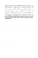
most locations were registered by 1937. The 1923 Act established a framework for subsequent legislation (Maylam, 1990). It embodied the central principles of segregation (and hence relocation) and influx control (the subject of further legislation in 1937 and 1945), the expectation that African urbanisation would be self-financing (leading to minimal house-building) and the co-optation of Africans, initially in an advisory capacity, to help the system operate. During the Second World War wartime shipping shortages led to rapid industrial growth and accelerated African urbanisation, but manpower and materials were concentrated on wartime needs and housing lagged badly behind. The same disparity continued in the late 1940s as municipalities were reluctant to increase the rates to subsidise large-scale African housing and still doubtful about the permanency of the urban African population. Its dramatic growth alarmed whites and became a central issue in the 1948 election campaign, in which the National Party’s use of swart gevaar (black danger) arguments contributed to its unexpected victory. Had Smuts’ United Party retained power, both urbanisation and urban residential patterns would probably have been approached more pragmatically. Instead it was to take four decades for the realities of social and economic geography to challenge the artificiality of apartheid cities. Davies’ (1981) model of the ‘segregation city’ (Fig. 1.1) represents South African cities before they were subjected to apartheid planning. It incorporates a central business district (CBD) which incorporates a small, peripheral Indian element to reflect Indian CBDs in Durban, Pietermaritzburg and Johannesburg. Coloured people never managed to establish such business districts and Africans were denied the opportunity to do so. Whites occupy most of the residential space, with a broadly sectoral differentiation of income groups, but with shortage of space forcing the most recent white housing developments to move out beyond a hitherto peripheral band of Indian and coloured housing. Low-income white housing and much of the African housing are close to the industrial sector, while barracks or compounds for African migrant workers are located within the industrial zone. The model includes some ‘islands’ of coloured and Indian housing within white areas and two extensive zones of mixing between whites and coloureds, reflecting central suburbs such as South End in Port Elizabeth, Woodstock and District Six in Cape Town. These segregation cities were already highly segregated. In Durban, indices of segregation for 1951 include the following (where 1.00 indicates complete segregation): Indian/white 0.91; Indian/African 0.81; coloured/white 0.84; African/white 0.81 (Kuper et al., 1958). In Port Elizabeth W. J. Davies (1971, p. 148) calculates indices of 0.89 for white/others and 0.80 for coloured/African segregation, also in 1951. These figures are higher than those calculated by Duncan and Davis (1953) for American cities, despite the use of smaller enumeration areas in the latter. In South African cities African/white segregation would have been almost total if domestic servants had been excluded. This raises a critical question: if further segregation is sought, why not achieve it by small, piecemeal adjustment? The extensive re-zoning and wholesale movement implemented by apartheid planners clearly implies that something more than segregation per se was intended. The apartheid city was part of the National Party’s long-term blueprint for South Africa, and as such it was intended
1 The Apartheid City
5
Fig. 1.1 The segregation city (Davies, 1981)
to provide for the future growth pattern of South African cities, providing a design that would allow for the growth of each population group in its own sector.
6
A. Lemon
1.3 Re-Ordering The Cities: The Group Areas Acts The Group Areas Acts of 1950 and 1966 produced distinctive apartheid cities which represented a major re-ordering of the segregation cities which preceded them. These Acts were a cornerstone of apartheid, and one to which P. W. Botha clung tenaciously to the end of his Presidency in 1989. By minimising inter-racial contact, they hindered transition from conflict pluralism to a more open pluralistic society (Lemon, 1980). Such a transition depends upon cross-cutting cleavages—individual allegiances and affiliations which cut across divides—which are most likely to be established within local communities. Race zoning served to keep people from knowing one another. Blacks, especially Africans, entered white homes and neighbourhoods largely as servants, while many whites never visited the African townships where most people lived. I recall an Afrikaans geographer saying ‘We who live in South Africa do not consider ourselves to live in apartheid cities’. Coming from a geographer this seems extraordinary, but it certainly confirmed the isolation in which it was possible for white people to live within their cities. The 1950 Act imposed control of inter-racial property transactions and inter-racial changes in occupation of property, which were subject to permit. No less than ten kinds of area were defined, but the ultimate goal was the establishment of areas for the exclusive occupation of each group. In final form, group area proclamations applied to both ownership and occupation. ‘Border strips’ might be designated to act as barriers to ensure that no undesirable contiguity occurred, and ‘future border strips’ could be set aside with future needs in mind. ‘Frozen zones’ could be proclaimed if an area was considered suitable for proclamation but was not immediately required: control in such areas would include the freezing of property transactions. Control over occupation could be withdrawn at any time by special proclamation: the possibility of establishing such ‘open’ areas caused much controversy, especially when it was decided to retain a black (usually Indian) commercial district in what had been proclaimed a white group area (Lemon, 1987). Initial implementation was the responsibility of the Group Areas Board. It needed the assistance of experienced surveyors, engineers and planners, which demanded local authority co-operation. Where this was refused, as in Cape Town, local authorities risked the imposition of an arbitrary zoning plan. When, after opportunity for objection and inquiry, the government finally approved the recommendations, their implementation was a matter for the Community Development Board, which dealt with housing, the development of group areas, the resettlement of displaced persons, slum clearance and urban renewal. Group areas legislation radically extended control over private property, with the Group Areas Development Act of 1955 providing for expropriation, regulation of the sale price and compensation. White acceptance of such measures clearly rested on the assumption that others would be the victims—hardly surprising given that whites passed the legislation, whites implemented it and whites alone were represented on local councils. No less than 99.7% of whites already lived in what became white group areas (Christopher, 1989), with the inner city and suburbs generally proclaimed
1 The Apartheid City
7
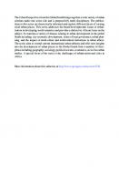
white and other groups consigned to the periphery. The vast majority of the 125,000 families moved in terms of group areas legislation were coloureds and Indians. Even greater numbers of Africans, almost certainly more than one million between 1950 and 1990, were moved in terms of amendments to pre-existing legislation, without even the semblance of consultation embodied in the Group Areas Acts. Ironically, the whole process led to the allocation of far greater financial resources to black housing than hitherto, but directed to fulfilling an ideological commitment rather than housing improvement per se, thus failing to address growing housing needs. In some cases people were physically better housed after removal, at least until their often poorly constructed homes deteriorated, but in other cases race zoning exacerbated overcrowding and squalor. The human damage inflicted by race zoning was and remains immeasurable. It unquestionably accentuated and even initiated the racial antipathy it was (supposedly) intended to prevent (Pirie, 1984a). Irrespective of any physical improvement or deterioration of housing conditions, many people were emotionally impoverished by the destruction of their communities and remoteness from the areas where they had grown up, where they might have experienced the emotional plenty amid material shortage observed by Hart and Pirie (1984) in Sophiatown, Johannesburg. It is appropriately Cape Town, the city most affected by group area removals, which is the subject of the most penetrating study of their devastating human impact. Probing the images of the city held by its coloured people, Western (1981) demonstrates the humiliating damage which removal and destruction of homes had on self-esteem and security as people had to re-learn their place on the edge of a callous urban society. By engaging powerfully with people and place, Western gives flesh to his conceptual theme, which remains the theoretical message of apartheid cities: ‘human social relations may be both space forming and space contingent’ (p. 5). The space formed has been modelled by Davies (1981, Fig. 1.2). An exclusively white CBD is surrounded by an extensive white residential core with space to expand in environmentally desirable sectors. Socio-economic patterns within white areas remained relatively undisturbed. Coloured and Indian group areas, and especially African townships (now including migrant worker hostels), were located peripherally within given sectors, also allowing for future expansion. Pushing the poor to the periphery invariably increased their journeys to work, especially where African townships were constructed across bantustan borders, as in Pretoria and the East Rand (Bophuthatswana and KwaNdebele), Durban (KwaZulu) and East London (Ciskei). Implementation of group areas proceeded slowly at first, and the real impact of the legislation was felt only in the 1960s and 1970s. This impact was not uniform, and the imprint of the colonial heritage survived eighty years of segregation and apartheid in some places (Christopher, 1990). In many small towns small communities of coloureds and Indians were deemed too insignificant to warrant a separate group area; sometimes such communities were resettled in a larger town (Christopher, 1991). On the eastern Witwatersrand in the 1960s attempts were made to concentrate coloureds at Boksburg and Indians at Benoni but the proclamation in the 1980s of some 57 new coloured and 15 new Indian group areas suggested that earlier policies of concentration had failed.
8
A. Lemon
Fig. 1.2 The apartheid city (Davies, 1981)
Overall, more than 1,300 group areas had been proclaimed by the end of 1987. Whites, who numbered 67% of the non-African urban population, were allocated 87% of the land in group areas. By 1985 10% of the total urban population still lived outside their designated areas, but only 5.7% in the Western Cape and 5.0% in Cape Town, where coloureds were removed from both African townships and once multi-racial suburbs now designated white (Christopher, 1989).
1 The Apartheid City
9
Segregation indices between whites and other groups were deceptively low in 1985, falling below 0.75 in 10% of towns and even below 0.5 in a few cases (Christopher, 1989). In some cases, mainly in Natal and the Transvaal, these figures are misleading because they exclude most of a town’s African population which lived in nearby bantustans. Otherwise low segregation indices are explained mainly by the housing of African live-in servants and also migrant workers in mine compounds in white group areas, whilst state institutions such as hospitals, prisons, military and police institutions also contributed to lower segregation indices. The economic effects of race zoning fell disproportionately on Indians owing to the extent of their commercial involvement and reduction of this may have been a conscious purpose of the 1950 Act (Meer, 1971, p. 23). Dislocation was particularly great in the Transvaal and the Cape where the small Indian minorities were particularly dependent on commerce. By 1966 only 7.5% of Transvaal Indians remained unaffected by group areas proclamations. In Pretoria even Indian traders not directly affected lost business because of the removal of Africans and coloureds living close to the ‘Asiatic bazaar’. In Pageview, Johannesburg, where Indians had used every device including Supreme Court action to fight removal to distant Lenasia, the government eventually assisted the city authorities in building the ‘Oriental Plaza’, but the level of rents prevented many small traders from re-establishing their businesses. Indian CBDs survived only in three cities. In Pietermaritzburg many Indian traders found themselves in the apex of a wedge of the city centre proclaimed for Indian and coloured residential use. After years of damaging uncertainty the country’s largest Indian trading area, in and around Grey Street in Durban, was proclaimed an Indian group area for trading and light industrial purposes in 1973, but its 13,000 residents were required to move; not all had done so when the decision was reversed a decade later. For Indian traders in many smaller Natal and Transvaal towns a forced move of two or three kilometres was enough to kill businesses which depended largely on white and African customers (Maasdorp & Pillay, 1977). Indian traders recovered some ground when the 1966 Group Area Act allowed proclamation of group areas for a specific use rather than a specific group. The procedures were cumbersome but by 1983 there were 26 such areas, mostly small. Many Indians managed to continue to own properties and trade outside their group areas by nominally registering under white ownership, as in upper Church Street, Pietermaritzburg. Eventually the widespread use of this ‘nominee’ system encouraged legalisation of open trading areas in 1984. Procedures were again cumbersome, but 90 CBDs were open to trading by all races by the end of 1988, nearly half of them in the Cape, with Indians the main beneficiaries.
1.4 Group Areas Under Pressure Legally enforced residential segregation came under increasing pressure in the 1980s. Low natural increase and the beginnings of a white exodus had produced a surplus of housing for whites, whereas other groups experienced substantial shortages (De
10
A. Lemon
Vos, 1986). Middle-class blacks increasingly bought homes in white areas using white nominees, and some through closed corporation deals. Thus ‘grey areas’— residentially mixed districts—were born, especially in Johannesburg. More liberal white cities such as East London, Durban and Pietermaritzburg began to seek varying degrees of de jure change, even threatening to defy the law (Pirie, 1987). Such authorities generally supported blacks using their right to apply for official consent to live in the ‘wrong’ area, and some 90% of the 2,716 applications made in 1985 were granted. Judicial decisions also compromised race zoning, most notably the Govender ruling by the Appeal Court in 1982 which gave discretionary jurisdiction to the courts on eviction orders, ruling that such orders could only be imposed when a full inquiry regarding all the circumstances in each individual case had first been undertaken. When the Attorney General of the Transvaal announced that he had not of late been instituting any prosecutions in terms of the Group Areas Act it was clear that the legislation was no longer working. In 1986 the State President was also faced with strong demands from business firms, some of which had begun to buy homes for black executives in Johannesburg’s affluent northern suburbs, for repeal or drastic amendment of the Group Areas Act. President Botha resisted such pressures, emphasising the critical importance of ‘own community life’ and the special need to protect low-income whites who were most vulnerable to change: they would face the greatest changes, but were among the least equipped members of society to do so, making them liable to social and political alienation. Yet the government had an interest, if it wished the growing black middle class to form a ‘bourgeois buffer’, to make it easier for middle-class and upwardly mobile blacks, especially Africans, to move out of segregated townships. In 1981 the Strydom Committee was appointed to advise the government on, inter alia, changes in group areas legislation. It recommended the replacement of the 1966 Act with a Land Affairs Act in terms of which ownership and occupation of land would be controlled by restrictions in title deeds. This was referred to the President’s Council, whose 1987 report endorsed the concept of local option: this would enable the government to maintain that it had responded to the claims of local democracy, enabling change in those areas that were challenging the law while conservative areas maintained the status quo. The government’s legislative response was characteristically equivocal: it tabled three Bills, two of them enabling the introduction and management of ‘Free Settlement Areas’ (FSAs), but the third seeking to override the Govender ruling and strengthen the enforcement of segregation everywhere else. This perfectly illustrates Huntington’s (1981) model of reform in a multi-ethnic society: one step forward but two steps back as it attempts to reassure ‘standpatters’—its conservative electorate. The first two bills were passed, but the third was rejected by the Indian and coloured houses of Parliament and referred to the President’s Council, a body with a white, National Party majority empowered by the 1983 constitution to decide the fate of Bills supported by only one or two houses. Remarkably, the Council failed to pass the Bill, referring it back for reconsideration. In doing so it was effectively signing the death warrant of race zoning, recognising that the pressures for change
1 The Apartheid City
11
were too great. By the late 1980s police investigations of complaints were leading to virtually no prosecutions (Urban Foundation, 1990) and by mid-1990 the government was reportedly issuing permits to blacks to live in the ‘wrong’ area by fax machine within 24 hours of application. In some instances officials even helped to protect blacks against hostile white neighbours and exploitation by white owners. The establishment of FSAs proceeded in 1990, but in an air of uncertainty once President de Klerk announced in April his hope of repealing the Group Areas Act. In September 1990 National and Democratic Party members of Johannesburg City Council united to ask for the whole city to be declared a FSA, while Cape Town City Council simply asked that the city be exempted from the Group Areas Act. The Act was duly repealed in June 1991, but the shadow of apartheid planning, like that of the colonial and segregation phases, will endure for decades to come, as subsequent chapters will reveal.
1.5 Urban Africans In The Apartheid City That the majority population of South Africa’s cities should be discussed separately in what seems almost like a postscript reflects official policies that marginalised them during the apartheid years. They were regarded as a labour force whose workers (and their dependants) ‘belonged’ in the bantustans, and as a necessary evil whose numbers should be minimised. To achieve this, the central state assumed increasing power over their lives, notably in 1972 when municipalities surrendered control of urban Africans to 22 Administration Boards which became responsible for housing, influx control and the regulation of African labour (Bekker & Humphries, 1985). An Act of 1951 sought to restrict peri-urban squatting. Attempts to link urban Africans with their respective bantustans were given substance by attempts to segregate ethnic groups within the townships from 1954 (Pirie, 1984b). In practice this primarily affected the multilingual African populations in Witwatersrand townships, but even there it was applied mainly in new townships and was much less effective than group areas segregation. Most fundamental was the Native Laws Amendment Act of 1952, which laid the basis for all state intervention to control the distribution of African labour between town and country, and between towns. Section 10 of the 1945 Natives (Urban Areas) Consolidation Act became mandatory, and was extended to include mineworkers. Africans could claim permanent urban residence only if they had resided there since birth, had lawfully resided there for fifteen years, or had worked there for the same employer for ten years. The Act also strengthened provision for the expulsion of Africans deemed surplus to labour requirements and sought to canalise labour through bureaux in rural areas. Hundreds of thousands of Africans were prosecuted annually for transgression of these ‘pass laws’. Even when these policies were at their peak they succeeded only in reducing rather than halting or reversing the growth of the urban African population.
12
A. Lemon
During the 1970s it became clear that apartheid policies were consciously striving to create a dual labour force differentiating migrant ‘outsiders’ from ‘insiders’ with Section 10 rights, a stabilised population better able to meet the growing need for skilled labour in a more sophisticated economy. ‘Insiders’ would be used more effectively by allowing them much greater freedom in the job market. Such policies were recommended in the 1979 report of the Riekert Commission (South Africa, 1985a) and eventually reflected in the 1985 Laws on Cooperation and Development Amendment Act. To house the ‘insiders’ vast new townships were built, distant from white residential areas and often close to industrial areas. Accommodation was provided across the borders of bantustans where commuting was deemed practicable, as in Mabopane, Bophuthatswana and Mdantsane, Ciskei. In South Africa the rural–urban migration common throughout the developing world was thus dammed up behind artificial boundaries, adding to the disembodied nature of the apartheid city. Meanwhile the legal definition of those who could potentially qualify for Section 10 rights was actually narrowed by the ‘independence’ of Transkei, Bophuthatswana, Venda and Ciskei, as children born after the ‘independence’ of the bantustan to which they were officially assigned could never acquire these rights (Budlender, 1985). As late as 1983 the government attempted to limit the effect of an unwelcome court judgement by amending Section 10 so that the family of someone who had worked for the same employer for ten years could only join him if he had a house of his own, rented or bought, or married quarters provided by his employer. By 1985 some 3.9 million Africans qualified in their own right and 1.7 million more as dependants. They were concentrated largely in Pretoria-Witwatersrand-Vereeniging, Port Elizabeth, Bloemfontein and Kimberley (Bekker & Humphries, 1985). But in Pretoria, the East Rand and Bloemfontein their numbers were steadily eroded as many were forced to accept offers of housing outside prescribed urban areas at Soshanguve, Ekangala and Botshabelo respectively. In Natal changes in Bantustan boundaries left few people formally qualified, but those who had been previously were treated as ‘administrative Section 10s’. In the Western Cape, few Africans in the Western Cape qualified owing to a policy of coloured labour preference. After the onset of recession in 1982, stricter controls over the entry of ‘outsiders’ led to the breakdown of labour bureaux and mine recruitment as the labour market contracted and the labour surplus increased, with the result that vast areas and populations were virtually excluded from the urban labour market. But for sheer survival many rural households simply had to find access to urban economies. By 1990 there were an estimated 7 million informal settlers in or around the urban areas, including many living in backyard shacks in formal townships or living as lodgers: densities of fifteen or more people per four-roomed house became widespread. In the metropolitan fringes people settled on whatever land they could find, including farms, smallholdings, church and vacant land. Many faced repeated eviction and relocation, but for some at least their persistence was eventually rewarded as communities became established, as in the Winterveld of Bophuthatswana. Others were forced to settle even further from the cities, in the KwaNdebele bantustan, Botshabelo and even in bantustan locations far from the most broadly defined urban functional regions,
1 The Apartheid City
13
as in the Nsikazi district of Kangwane, near Mmabatho in Bophuthatswana and in districts of Lebowa near Pietersburg. New official thinking was reflected in the report of a President’s Council committee which viewed African urbanisation as not only inevitable but ‘an opportunity to use … its people in such a way that the end result will be an improvement in the quality of life’ (South Africa, 1985a, p. 26). It proposed a shift from discriminatory influx control to ‘orderly urbanisation’. This would involve directing urbanisation using indirect incentives and disincentives but also control measures, mainly through existing legislation. Influx control was duly abolished in 1986 with the repeal of the 1945 Act and partial or entire repeal of 33 other laws. Whilst this constituted a major reversal of key apartheid policies, the continuing allocation of the greater part of the cities to whites, coloureds and Indians left racial discrimination firmly in place, while the fact that Africans were the only group still seeking to urbanise made them the prime objects of any constraints. Land and housing were used as material constraints in distributing labour and population, in conjunction with decentralisation and deconcentration programmes developed under the regional development strategy which had been operative since 1982 (Tomlinson & Addleson, 1987). In 1986 the Black Communities Development Amendment Act made possible full home ownership in the townships and enabled increased supply of land for African housing. The government indicated its intention to focus on supplying land and bulk infrastructure but withdrawing from direct housing supply, leaving this to the private sector. Its continuing determination to control urban growth was demonstrated by measures in 1988 to control slums and squatting, both criticised given the overall housing shortage. African urbanisation also posed challenges for local government in apartheid cities. Prior to 1977 the only official representation of urban Africans was through Advisory Boards and Urban Bantu Councils, neither of which significantly influenced white municipalities or, after 1972, Administration Boards. Widespread unrest in 1976, the year of the Soweto riots, led to the establishment of Community Councils the following year, but these were compromised by their ambiguous relationship with the Administration Boards, especially with regard to housing allocation and influx control, and polls were low in the minority of wards contested. The Town Councils established in 1982 were regarded as independent Black Local Authorities (BLAs) but were subject to wider powers of ministerial intervention than their white counterparts. They were expected to be self-sufficient financially, despite pressure of population numbers on buildings and services which demanded large capital inputs. Most housing remained sub-economic rental property, while significant commercial and industrial development had been precluded by decades of apartheid legislation, thus revenue from these sources was wholly inadequate to provide for the upgrading of infrastructure. When BLAs resorted to rent increases rent boycotts became a key form of resistance, and a wave of violent unrest spread to much of the country until brought under control by police and army action in 1986. These financial and political pressures, and threats to councillors regarded as ‘collaborators’, caused the collapse of many BLAs.
14
A. Lemon
Just as the failure of Community Councils was attributed to lack of autonomy, failure of BLAs was blamed solely on financial problems rather than their fundamentally unacceptable racially defined structures. The immediate government response was to use the National Security Management System to implement new policies and controls to stabilise the townships. During 1986 joint management centres (JMCs) were established in 34 townships identified as ‘high-risk’ security areas, with the object of regaining control through a combination of repression and upgrading of conditions (Boraine, 1989). They largely failed, facing growing resistance and a steady revival of civic and street structures, many of which proved able to negotiate directly with state and parastatal bodies. The state responded to the financial unviability of BLAs by including them in proposed Regional Services Councils (RSCs), hitherto planned to include only whites, coloureds and Indians. RSCs were officially regarded as horizontal extensions of local authorities, charged with provision of bulk services and promotion of infrastructure ‘where the need is greatest’ (South Africa, 1985b). This meant largely African townships, although in practice areas across bantustan borders and informal areas were not included. RSCs were nominated by participating authorities from all race groups, but voting power was determined by the volume of services consumed, which still left whites with a controlling interest. For the most part, however, they operated consensually and did give redistribution the priority intended (Lemon, 1991). Nevertheless they failed to win greater legitimacy for the racially based local government structures on which they were based: the latter were undermined by community-based organisations and alternative civic structures which had emerged from popular action. In 1990 President de Klerk implicitly recognised this when he finally acknowledged the need for a non-racial system of local government.
1.6 Concluding Questions By 1990, then, the foundations of apartheid cities were no more. Influx control laws had been repealed in 1986, the Group Areas Act in 1991 and the need for a non-racial system of local government officially acknowledged in 1990. After four decades of a system intended to provide a long-term framework to contain and separate South Africa’s major population groups at the urban scale, the speed of change was dramatic: most of the legislative changes had already taken place when Nelson Mandela became President in 1994. But this certainly did not guarantee rapid transformation of apartheid cities on the ground. Would their influence prove as enduring as that of the colonial and segregation cities before them? A generation after the political transition, to what extent are ‘homes still apart’? How far has post-apartheid urban government brought genuine redistribution and, in doing so, transformed South Africa’s cities? These are some of the questions which will be addressed in the case studies that follow.
1 The Apartheid City
15
References Abu-Lughod, J. (1980). Rabat: Urban apartheid in Morocco. Princeton University Press. Bekker, S. B., & Humphries, R. (1985). From control to confusion: The changing role of Administration Boards in South Africa, 1971–1983. Pietermaritzburg: Shuter and Shooter. Boraine, A. (1989). Managing the urban crisis, 1986–1989: The role of the National Security Management System. In G. Moss & I. Obery (Eds.), South Africa contemporary analysis: South African Review Five (pp. 1106–1118). Johannesburg: Ravan. Budlender, G. (1985). Incorporation and exclusion: Recent developments in labour law and influx control. South African Journal on Human Rights, 1(part 1), 3–9. Christopher, A. J. (1983). From Flint to Soweto: Reflections on the colonial origins of the apartheid city. Area, 15, 145–149. Christopher, A. J. (1989). Spatial variations in the application of residential segregation in South African cities. Geoforum, 20, 253–267. Christopher, A. J. (1990). Apartheid and urban segregation levels in South Africa. Urban Studies, 27, 417–436. Christopher, A. J. (1991). Changing patterns of group area proclamation in South Africa, 1950–1989. Political Geography Quarterly, 10, 240–253. Davenport, R. (1971). The beginnings of urban segregation in South Africa: The Natives (Urban Areas) Act of 1923 and its background (p. 15). Grahamstown: Institute of Social and Economic Research, Rhodes University, Occasional Paper no. 15. Davies, R. J. (1981). The spatial formation of the South African city. GeoJournal, Supplementary Issue, 2, 59–72. Davies, W. J. (1971). Patterns of non-white population distribution in Port Elizabeth with special reference to the application of the Group Areas Act. Port Elizabeth: Institute of Planning Research, Series B, Special Publication 1. De Vos, T. J. (1986). Housing shortages and surpluses and their bearing on the Group Areas Act. In M. Rajah (Ed.), The future of residential group areas (pp. 102–148). Pretoria: School of Business Leadership, University of South Africa. Duncan, O. D., & Davis, B. (1953). The Chicago urban analysis project. University of Chicago. Fair, T. J. D., & Davies, R. J. (1976). Constrained urbanization: White South Africa and black South Africa compared. In B. J. L. Berry (Ed.), Urbanization and counterurbanization (pp. 145–168). Beverly Hills: Sage. Gordimer, N. (1962). A world of strangers. Harmondsworth: Penguin. Hart, D. M., & Pirie, G. H. (1984). The sight and soul of Sophiatown. Geographical Review, 74, 38–47. Huntington, S. P. (1981). Reform and stability in a modernizing, multi-ethnic society. Politikon, 8(2), 8–26. Kuper, L., Watts, H., & Davies, R. J. (1958). Durban: A study in racial ecology. London: Jonathan Cape. Lemon, A. (1980). Federalism and plural societies: A critique with special reference to South Africa. Plural Societies, 11(2), 3–24. Lemon, A. (1987). Apartheid in transition. Aldershot: Gower. Lemon, A. (1991). Restructuring the local state in South Africa: Regional Services Councils, redistribution and legitimacy. In D. Drakakis-Smith (Ed.), Urban and regional change in Southern Africa (pp. 1–32). London: Routledge. Maasdorp, G., & Pillay, N. (1977). Urban relocation and racial segregation: The case of Indian South Africans. Durban: Research Monograph, Department of Economics, University of Natal. Mabin, A. (1986). Labour, capital, class struggle and the origins of residential segregation in Kimberley, 1880–1920. Journal of Historical Geography, 12, 4–26. Maylam, P. (1990). The rise and decline of urban apartheid in South Africa. African Affairs, 89(354), 57–84.
16
A. Lemon
Meer, F. (1971). Indian people: Current trends and policies. In South Africa’s minorities (pp. 13–32). Johannesburg: SPRO-CAS Publication no. 2. Paton, A. (1958). Introduction. In Kuper, Watts Davies, op. cit, 13–16. Peach, C. (Ed.). (1975). Urban social segregation. London: Longman. Pirie, G. H. (1984a). Race zoning in South Africa: Board, court, parliament, public. Political Geography Quarterly, 3, 207–221. Pirie, G.H. (1984b). Ethno-linguistic zoning in South African black townships. Area, 16, 291–298. Pirie, G. H. (1987). Deconsecrating a ‘Holy Cow’: Reforming the Group Areas Act. In G. Moss & I. Obery (Eds.), South African Review 4 (pp. 402–411). Johannesburg: Ravan. Simon, D. (1984). Third world colonial cities in context: Conceptual and theoretical issues with particular respect to Africa. Progress in Human Geography, 8, 493–524. Smit, P., & Booysen, J. J. (1977). Urbanization in the homelands—A new dimension in the urbanization process of the black population of South Africa? University of Pretoria: Institute for Plural Societies, Monograph Series on Inter-group Relations, no .3. South Africa. (1985a). Report of the Committee for Constitutional Affairs of the President’s Council on an urbanisation strategy for the Republic of South Africa. Cape Town: Government Printer, P.C. 3/1985. South Africa. (1985b, July 31). Regional Services Councils Act (No. 109). Cape Town: Government Gazette 9868. Swanson, M. (1983). ‘The Asiatic Menace’: Creating segregation in Durban, 1870–1900. International Journal of African Historical Studies, 16, 401–417. Tomlinson, R., & Addleson, M. (1987). Regional restructuring under apartheid: Urban and regional policies in contemporary South Africa. Johannesburg: Ravan. Transvaal. (1922). Report of the transvaal local government commission. TP 1/1922. Urban Foundation. (1990). Policies for a new urban future: Tackling group areas policy. Johannesburg: Urbanization Unit: The Urban Foundation. Western, J. (1981). Outcast Cape Town. London: George Allen and Unwin. Western, J. (1984). Autonomous and directed cultural change: South African urbanization. In J. Mercer & D. Sopher (Eds.), The city in cultural context (pp. 205–236). London: George Allen and Unwin. Western, J. (1985). Undoing the colonial city? Geographical Review, 75, 335–357. Winters, C. (1982). Urban morphogenesis in Francophone Africa. Geographical Review, 72, 139– 154.
Chapter 2
Cape Town: Living Closer, Yet, Somehow Further Apart Gustav Visser and Anele Horn
2.1 Introduction There has been rapid change in Cape Town since Cook (1991) penned her thoughts on this city in Homes Apart some 30 years ago. In many ways, Cape Town is a very different city, yet, in others, e.g. spatial terms, it remains strikingly similar. Whereas the majority of issues highlighted then are still relevant, their subsequent development has morphed into something quite different. More than a mere update of Cook’s contribution is needed, as so many aspects of the city have changed in the ensuing decades. In addition, the type of information communicated by Cook then is now reflected in the regularly updated Integrated Development Plans or Spatial Development Frameworks published by the City of Cape Town. In the conclusion of Cook’s (1991, p. 42) contribution it was suggested that in the context of the time, Cape Town needed to stimulate broader development so as to generate more employment for a growing population, rather than the provision merely of housing and related infrastructure in the absence of such economic expansion. The view was that a then “conventional approach” that relied on the provision of largescale housing provision “was neither practical nor acceptable” and radical change was required. This, it was argued, involved responsive and positive reactions to innovative ideas, progressive thinking, being prepared to encourage individual endeavour and above all the creation of enabling social and physical environments that would break the legacy of the past and achieve a city characterized by home for all (Cook, 1991, p. 42). This chapter reflects on characteristics and challenges Cape Town (Fig. 2.1) has since faced and it will be illustrated that many of Cook’s hopes have not been met, specifically around housing and the local economy. We do so by first considering G. Visser (B) · A. Horn Department of Geography and Environmental Studies, Stellenbosch University, Stellenbosch, South Africa e-mail: [email protected] © The Author(s), under exclusive license to Springer Nature Switzerland AG 2021 A. Lemon et al. (eds.), South African Urban Change Three Decades After Apartheid, GeoJournal Library, https://doi.org/10.1007/978-3-030-73073-4_2
17
18
G. Visser and A. Horn
Fig. 2.1 Cape Town metropolitan
spatial planning frameworks that aim to manage a number of processes pertinent to Cook’s investigation. Thereafter, demographic changes that in many ways frame other types of changes in the city are considered along with the transfiguration of the economic base of the city. Attention then turns to changing housing trends that are fundamentally different from three decades ago. The spatial scope of the investigation
2 Cape Town: Living Closer, Yet, Somehow Further Apart
19
includes new settlements that did not form part of Cape Town until recently and their spatial relationship to more established neighbourhoods in the city.
2.2 Spatial Planning and Politics Since 1990 Before Cook penned her chapter, the city of Cape Town was known for its relatively “liberal” stance against apartheid. Researchers and academia at the time considered the main reasons for violence and dissatisfaction in Cape Town to be poor quality living environments, lack of good public spaces, the unifunctional and monotonous nature of these environments and the physical urban structure that located the poorest people on the far edge of the city. Following the post-1994 municipal reforms, the first Cape Town Metropolitan Spatial Development Framework (MSDF) approved in 1996 (notably also one of the first metropolitan wide spatial planning frameworks in the country) put forward planning proposals that were very much in vogue with the new urbanist planning principles at the time, but most importantly represented spatial ideals to promote social and spatial integration, vastly different from the former regime’s structure plans. These proposals related to providing a greater mix of land uses, promoting compact urban development and increased densities along demarcated nodes and corridors, and encouraging urban development that will be able to support an efficient public transportation system. Municipal planning relied strongly on the MSDF to identify areas where development should be directed, and where it should be discouraged. Watson (2002) observed that the ability of Cape Town spatial planners to build a discourse coalition that synchronized with both macro-economic philosophy and political sentiment of the time, allowed them a degree of status, across the political spectrum, which they had not enjoyed before. The concept proposed in the MSDF, of the compact, integrated and equitable city, as an antidote to the segregated, apartheid city, proved to be an influential one. This immediate post-1994 spatial planning response also solicited a number of critiques, most notably the fact that whilst statutory planning would be able to control or prevent development in certain areas, it did not possess the ability to function as a tool to direct specific kinds of development in demarcated areas such as nodes and corridors. Much of the new development expected in these areas would have to be initiated by the private sector, which could not be bound by law in terms of where it would invest. The MSDF was particularly criticized by pro-expansion stakeholders concerned that the statutory plan would hamper future private sector driven growth. It was also argued that the MSDF provided too much detail in terms of land use specification in the city, an approach that could be interpreted as too rigid for a dynamic urban environment. Overall it was suggested that the MSDF was inflexible and that a spatial plan that can respond to unpredictable economic and demographic shifts would be more appropriate (Watson, 2002). Following the formation of the Unicity in 2000, subsequent MSDFs maintained the structuring elements of nodes and corridors, but placed significant emphasis on taking cognisance of the city’s space economy, and appeared less ambitious regarding
20
G. Visser and A. Horn
the spatial plan’s ability to control the direction of new public sector growth. In Cape Town the Democratic Alliance (DA) was elected as ruling party in 1994. Following African National Congress (ANC) rule from 2002 to 2006, the DA was re-elected during the local government elections in 2006 and has been the ruling party to date. The political instability resulting from the opposing political parties, as well as from rivalry between tiers of government (the ANC being the national ruling party) has however greatly impacted the municipality’s ability to achieve meaningful spatial transformation. In addition, the presence of a strong private capital lobby and a neoliberal stake influencing political administration, have resulted in MSDFs since 2001 being perceived as overly conservative and unstrategic in accommodating future growth. Since 2016 this perceived conservative approach to growth has been contested by both private development stakeholders as well as by local political leaders. This resulted in a controversial reorganisation of the Metropolitan Spatial Planning Department as well as a reorientation of the SDF to be aligned with a more growth-friendly agenda (Olver, 2017). In large part these various planning frameworks have become re-active to changes in demography, the economy, housing changes and transportation trends, that have not followed their ambitions over which the Metropolitan government seemingly has little control.
2.3 Demographic Changes in Cape Town Since 1990 To date Cape Town remains the second most populous city in South Africa (after Johannesburg) and the provincial capital of the Western Cape. The city is however a vastly reduced administrative entity following the re-demarcation in 1994 of the country’s former four provinces to nine new provinces (City of Cape Town, 2017). In terms of the spatial extent of the city, the metropolitan area of Cape Town has changed dramatically since Cook’s investigation. This change is rooted in the collapse of the apartheid regime and the repeal of Acts relating to the freedom of movement and job reservation such as the Group Areas Act (1950); Prevention of Illegal Squatting Act (1951); and the Reservation of Separate Amenities Act (1953). Cape Town’s geographic extent has increased since the early 1990s and currently comprises nearly 2500 km2 (City of Cape Town, 2019a). The process of ‘re-demarcation’ as witnessed across South Africa was protracted and complicated (see Boraine et al., 2006; Van Donk et al., 2008; Visser, 2001; Watson, 2002, for an extensive analysis). Rife conflict between the national ruling party since 1994 (i.e. the African National Congress (ANC) and the New National Party (NNP)) over the outer municipal boundary as well as the inner organisation of the metropolitan area settled in 2000 following the reframing of the metropolitan entity to form the “Unicity” as it was then referred to. This meant that both the original Cape Metropolitan Council (CMC) and the former Municipal Local Councils (MLC’s) were now included in the same metropolitan entity. Comparative statistics for Cape Town are somewhat challenging to calculate as a result of these administrative boundaries vastly differening from what they were in
2 Cape Town: Living Closer, Yet, Somehow Further Apart
21
the early 1990s (Watson, 2002; Visser, 2001). At that time, the population of Cape Town was calculated at around 3 million, with a growth rate of ~2.5% p.a. over ten years. However, this has increased substantially over the past decades, and it is estimated that there are currently approximately 4.5 million residents in the larger metropolitan region (City of Cape Town, 2017). In addition to the natural increase in population of the city, the high population growth rate in the metropolitan region is also due to the increasing volume of job-seeking migrants, especially from the Eastern Cape (Du Plessis & Jacobs, 2016). The racial profile of the city has changed as well. When Cook (1991) undertook her investigation, the racial composition of the city was ~48% coloured, ~27% black and ~23% white. Currently, the majority population groups remain the coloured (~45%) and black (~38%) cohorts and a proportionately far smaller white (~15%) one (World Population Review, 2019). It is projected that by 2035 the population size will approach six million whilst in all likelihood slowing considerably. The population density is around 1,500 people per square kilometre, but this varies greatly, depending on specific locations (City of Cape Town, 2016; Du Plessis & Boonzaaier, 2015). The total number of households in Cape Town increased from around 650,000 in 1996 to well over a million at present, in part reflecting the national trend towards smaller household units across all population groups. In 1996 the average household in the city had 3.92 members, which has declined to 3.5 (City of Cape Town, 2017), currently below that of developing countries (five members) and moving closer to that of many developed countries (two to three members). This is already the case in certain population groups, notably the white and black groups (with the former averaging 2.5, while the latter is at 3.25) (City of Cape Town, 2017).
2.4 A Changing Economic Base Since the Early 1990s Unlike Johannesburg or Durban, Cape Town was never a major industrial city, nor has this been part of its urban imaginary (Pirie, 2007; McDonald, 2008). Therefore, its historic economic functions were centred on administration (both provincial and national), financial services (especially insurance companies), tourism and some manufacturing in the form of the clothing and related industries (Sinclair-Smith, 2015; City of Cape Town, 2017). The opening-up of the South African economy to world trade post-apartheid impacted the economies of Durban and Johannesburg in different ways to Cape Town (Rodrik, 2008; McDonald, 2008; SinclairSmith & Turok, 2012). Cape Town’s economy was services-based, a sector that witnessed economic expansion globally since the 1990s (McDonald, 2008). In addition, growing interest in the region as a tourist destination played a dominant role in expanding the local and regional economy (McDonald, 2008; City of Cape Town, 2017). Cape Town is the economic hub of the Western Cape Province and South Africa’s second main economic centre. The city’s GDP is ~US$56.8 billion with a GDP per capita of ~US$16,000, which is significantly higher than the national average
22
G. Visser and A. Horn
of ~US$6400 (City of CapeTown, 2017). https://en.wikipedia.org/wiki/Cape_Towncite_note-brookingsgdp-6. The sectoral drivers of Cape Town continue to support a serviced-driven economy (City of Cape Town, 2019a). Tertiary sector industries contribute almost 80% to the city’s total gross added value (GAV) (City of Cape Town, 2017). Like most cities, the primary sector in Cape Town is very small, contributing less than 1% of the city’s economic output. Tertiary sector industries contributed most of the economic growth of the city over the past three decades. In particular, the finance and insurance (Sanlam, Old Mutual, for example) industry contributed over 30% to the city’s economic growth, with strong contributions also coming from retail (Pick n Pay; Shoprite, TFG, Woolworths), business services and wholesale trade (City of Cape Town, 2017). A recent addition has been that of the media sector (Visser, 2014) with South Africa’s largest company by value, NASPERS, headquartered in the CBD. The fastest growing economic sectors in Cape Town are more capital intensive than labour intensive and mostly demand workers who are highly skilled. This presents exceptional challenges as it excludes many of the newly urbanised population. The unemployment rate in Cape Town still hovers around 20%, which is the lowest in South Africa, but still a key concern (City of Cape Town, 2019b). Robust economic growth has also been registered in sectors such as real estate. This economic category generally has lower employment multiplier impacts than those associated with the manufacturing or agricultural sectors, the latter being more labour intensive but offering lower remuneration and less employment security. This has resulted in a very specific economic geography. In the early 2000s it was anticipated that central Cape Town would follow the trajectory of other South African cities i.e. inner-city decay, capital flight and uncontrolled decentralisation at the urban fringe. It was argued that “in many respects the Cape Town experience mirrors those of central city areas in other major South African cities” (Dewar, 2004, p. 91). Yet, a set of interventions led to a very different outcome both in the CBD and at its urban periphery (see Visser, 2016; Horn, 2018a, 2018b; Odendaal & McCann, 2016; Miraftab, 2012 on recent ideas concerning this), prompting Pirie (2007, p. 125) very soon after to pen an article overturning Dewar’s analysis and sentiments. Other scholars have also recognised that Cape Town is not similar to other South African central city areas, e.g. Bickford-Smith (2009, p. 1763) who remarked that “in so far as it thinks of itself at all, Cape Town thinks of itself as a tourist city”. Sinclair-Smith and Turok (2012) illustrated that despite a dramatic increase in non-central economic development, the Cape Town CBD remains accountable for almost a quarter of business turnover (excluding government services), nearly two-and-a-half times the turnover of the second largest node (Bellville), thereby re-affirming its monocentric dominance. In contrast to three decades ago when the city arguably had three major business nodes, it now has five. In addition to the CBD, the Bellville/Tyger Valley corridor and Claremont commercial nodes also host many offices and corporate headquarters. The controversial development of Century City to the north-east of the city in 1997 was the first large-scale decentralised node outside central Cape Town after apartheid. Century City is a 250 ha gated suburb developed on a green field site, and structured
2 Cape Town: Living Closer, Yet, Somehow Further Apart
23
as a mixed-use development including entertainment, residential, retail and office components. In many ways it is an expression of postmodern urbanism (Marks & Bezzoli, 2001) and an example of economic, cultural and social decentralisation at a grand scale similar to a range of developments in cities such as Durban (Hannan & Sutherland, 2015; Houghton, 2013) and Johannesburg (Harrison, 2017; Dirsuweit & Schattauer, 2004). A further economic hub, although mostly retail-based, has been that of the Somerset West/Strand node, which has to date pervaded academic analysis. The increasing growth in private capital in Cape Town has resulted in the neoliberalist agenda gaining a momentous foothold in development and planning of the city’s spatial economy (Horn, 2018a, 2018b). The presence of such strong market forces in shaping the city can be witnessed in the growing number of privatised commercial and retail spaces, as well as the exclusive nature of these spaces in Cape Town, especially in the most prominent nodes of the city such as the Cape Town CBD, Bellville and Claremont (McDonald, 2008; Miraftab, 2012). These areas are in stark contrast to other parts of the city that remain dependent on public investment and social development initiatives.
2.5 Neighbourhood Changes and New Housing Projects Cape Town has many notable neighbourhood clusters of which the very general demographic characteristics of the early 1990s have changed relatively little. At the individual neighbourhood scale, however, some dramatic shifts have occurred in terms of class and race (Geyer & Mohammed, 2016). It is interesting to note that very little is written about the wealthier parts of South African cities, save for the few authors having engaged with residential gating and exclusivity (see Lemanski et al., 2008; Landman, 2006). Indeed, looking beyond the urban poor has been somewhat of a post-apartheid predilection (Visser, 2013). As a result we know little about wealthier neighbourhoods in Cape Town and indeed other South African urban settlements. For most of the past 50 years, debates and policy foci have been on poorer “nonwhite” cohorts (Goebel, 2007; Massey & Gunter, 2019; Huchzermeyer, 2001). The concept of ‘homes still apart’ has greater resonance when viewing the whole socioeconomic spectrum of housing Cape Town’s population (Lemanski’s work, on downward raiding 2014; and Newton & Schuermans, 2013; Schuermans, 2016, 2017 on the white middle classes). The apartheid city model (see Chapter 1), as described by Davies (1981) many years ago, highlighted that the urban poor were located at the furthest reaches of the city. This remains largely true, but with some notable variations. As in South Africa’s other large cities, three distinct housing trends and spatial locations can be identified in Cape Town; (1) the large-scale expansion of subsidised housing along with informal housing and their subsequent spatial expression at the city’s periphery; (2) the large-scale establishment of middle and upper income gated housing development in former white local authority neighbourhoods and also along
24
G. Visser and A. Horn
the periphery of the city; and (3) the repopulation, as well as the densification, of middle and upper income housing in the central parts of the city (Parnell, 1989; Huchzermeyer, 2003; Shapurjee & Charlton, 2013; Harrison & Todes, 2015).
2.5.1 Expansion of Subsidised Housing and Informal Housing The expansion of both government provided/subsidised housing and informal housing development on the periphery of the city was not recommended by Cook. Both these housing formats are, however, now prominent features of Cape Town’s built environment (Massey, 2013). These developments have been the consequence of large-scale urbanisation over the past three decades. An important relatively new neighbourhood/township has been that of Khayelitsha (literally meaning new home), located some 30 km south-east of the CBD. Within the current geography of Cape Town, this township does not represent a typical peripheral location; however, given its poor connectivity to major economic nodes within the city, it bears all the challenges presented by low-income housing projects at the urban fringe. In addition to pervasive poverty, the area is regularly subject to upsurges of xenophobia and urban violence. Other peripherally located ‘township areas’ are found in the Helderberg basin and towards the north of the city. Unique to the South African context is that nearly all housing settlements of the urban poor of Cape Town are increasingly hemmed in by the city’s natural physical geography. The Emergency Servicing of Informal Settlements Project (ESIS) was the first phase of a three-phased incremental upgrading plan outlined in the City’s framework for Upgrading Informal Settlements, and preceded the national Department of Housing’s Informal Settlement Upgrading Programme (Graham, 2006). Upgrading of informal settlements have taken place since 2000 in Khayelitsha, Mitchells Plain, Gugulethu and Marconi Beam. The South African area-based urban renewal programme included projects in Khayelitsha CBD as well as in Mitchells Plain town centre. In these two projects similar to other urban renewal projects, investment was made in hard infrastructure and soft social interventions such as urban and public open space design and safety (Donaldson et al., 2013a, b). Research on informal upgrading as well as urban renewal programmes in Cape Town reveals that, while investment in hard and soft infrastructure marks a novel beginning for area-based interventions, social and local economic development needs of individual communities need to form an integral part of forward planning and investment in an area. The N2 gateway project in Cape Town was presented by government as a “flagship” project of the Breaking New Ground strategy (2004) to promote an integrated society by developing sustainable human settlements and quality housing within a subsidy system for different income groups. On a 10-km strip of land, between the city and the airport, newly developed rental flats have been built, and in the following phase, terraced family houses were constructed. In order to provide these 22,000
2 Cape Town: Living Closer, Yet, Somehow Further Apart
25
housing units, massive informal settlement clearance was necessary (Rust, 2006). Although the project continued for more than seven years, the emerging of Langa as a well located lower-income suburb of Cape Town is a significant improvement of this former apartheid township. The appearance of informal housing has certainly not only been on the periphery of the city—in some cases it develops in close proximity to formal urban residential areas. What is interesting in these developments, is that poor and relatively wealthy cohorts are now in far greater proximity to one another. The Hout Bay/Imizamo Yethu and Fish Hoek/Noordhoek/Masiphumelele examples are arguably the most extreme, but similar observations can be made in state-assisted projects such as Athlone and the planned social housing project on the former Ratanga Junction site next to Century City. As a result of the scale in growth of informality there has been immense pressure on the local municipality for the delivery of state-assisted housing. The Philippi Horticultural Area (PHA) presents an example of the infiltration of informal housing and state-assisted housing on to well-located land. Unfortunately, the horticultural value of the land contributed to controversy regarding this initiative (Battersby, 2016). The Helderberg basin, which encompasses former white municipalities such as Somerset West and Strand, has seen the establishment and expansion of informal and subsidised housing ‘infilling’. In many of these cases, the only boundary between vastly different cultural, economic and social realities is a road or highway. This, in turn, has led to a very rapid expansion of gated developments, be they commercial or residential or both.
2.5.2 Gated Housing Development A key residential development research theme since the early 1990s has been the considerable expansion of gated neighbourhoods and housing estates—a trend seen across the South African urban landscape (Landman, 2000, 2004, 2006; Landman & Schönteich, 2010). Spocter (2012) has argued that gating in Cape Town has a far longer lineage than contemporary urban scholars might acknowledge. Yet, relative to other South African cities such as Johannesburg, gated neighbourhoods were slow to develop in the Cape Town area. In addition, there was substantial local government resistance to the ‘booming/gating’ of neighbourhood roads into gated precincts. However, there has been a significant expansion of gated developments, including retrofitted booming/gating over the past thirty years across the city. In many ways, as highlighted by Ferreira and Visser (2007) gating is arguably the most common format in which new formal mortgaged housing is developed in South Africa, and Cape Town is no exception. Gated estates are most often developed at the periphery of urban areas where land poses fewer constraints, neighbourhood objections are fewer and land and development costs are lower allowing for increased delivery of housing units (Horn, 2018a, 2018b). There has been extensive expansion of gated estates in various formats in Cape Town, targeting a range of generally middle and higher income earners on the
26
G. Visser and A. Horn
urban edges in the northern suburbs such as Bloubergstrand and fanning out across Durbanville, Brackenfell and towards the eastern suburbs in the Helderberg basin, including Somerset West and Strand. The northern suburbs largely comprised white Afrikaans-speaking residents in the early 1990s. This profile has become notably more diverse in terms of both class and race—depending on which neighbourhoods one focuses. Bellville retains its business, retail and residential functions but has become more spatially expansive and densified. The Durbanville area remains a white middle to upper income residential and retail area. Brackenfell and Kraaifontein, on the other hand, have seen considerable new commercial, retail and densified residential housing trends emerging as well as poorer and non-white in-migration (Jacobs & Du Plessis, 2016; Sinclair-Smith, 2015). The development of Century City and Canal Walk in 1997 and the city’s subsequent decentralised expansion resulted in a gated city imbedded in a city. Another noteworthy trend in gated development at the urban periphery, in South Africa as well as elsewhere in the south, is the construction of entirely new private towns or exclusive satellite cities some distance from the urban core (Watson, 2014, 2016; Harrison, 2017). Despite grave concerns regarding the viability of such investments (drawing on lessons from similar projects such as Atlantis), the Cape Town local authority in 2012 approved a proposal for a satellite city potentially housing 1 million inhabitants 50 km to the north of Milnerton (Ciriola, 2014). Endorsement of projects such as these represents a departure from the post 1994 spatial development objectives of the city, which always promoted infill and densification of new housing opportunities into the existing urban fabric.
2.5.3 Repopulation, Densification, Gentrification and Central Cape Town Not everyone wants to live in locations at some distance from higher order economic opportunities and various forms of recreation and leisure services, hence increased interest in living closer to work in central Cape Town neighbourhoods has been observed. The CBD and adjacent neighbourhoods such as De Waterkant, Gardens and Woodstock have seen considerable change and densification (Bickford-Smith, 2009; Dewar, 2000; Donaldson et al., 2013a,b; McDonald, 2008; Newton & Schuermans, 2013; Pirie, 2007; Schuermans, 2016, 2017; Visser, 2016, 2019a, 2019b, 2019c). The CBD has undergone significant diversification in economic structure and certainly towards upward socio-economic mobility as well in terms of an expanding residential population and accompanying services, leisure or retail (Pirie, 2007; Visser, 2016). In this respect Cape Town is very different from other South African cities. Adjacent to the CBD and broader so-called City Bowl, the Atlantic Seaboard, including the neighbourhoods of Green Point and Mouille Point, has also seen considerable socioeconomic upward mobility (Visser, 2016). Neighbourhoods such as Clifton, Camp’s
2 Cape Town: Living Closer, Yet, Somehow Further Apart
27
Bay and Sea Point have become even more desirable than they were thirty years ago. An increased clustering of wealth and supporting infrastructure including not only housing but high-level employment opportunities and services are observed in these areas (Sinclair-Smith, 2015). The southern suburbs mostly still comprise white English-speaking residential suburbs. The composition of this area has changed in the sense that it is (like the northern suburbs) more densely populated and has seen more expansion in the economic base in the services industries (Sinclair-Smith & Turok, 2012). The neighbourhoods in the furthest reaches of the southern suburbs, best described as the False Bay area, have seen considerable changes over the past three decades ranging from gentrification to the establishment of informal housing settlements. Although the repopulation of Cape Town’s CBD is not unique, the class and race profile is. In Durban, Johannesburg and Pretoria, the number of inner-city residents, who are mostly at the lower end of the socio-economic spectrum, has increased. This was not the case in central Cape Town. Unlike Dewar’s rather narrow and ultimately pessimistic view of central Cape Town, the immediate fringe areas were at that very time in a state of reconfiguration by the late 1990s. Indeed, as Garside (1993) as well as Kotze (2013) pointed out, something was happening that was different from the idea of endless suburbanisation and the abandonment of the inner-city and surrounding neighbourhoods. There are various ways in which to interpret the changes of the time, and one might be easily tempted to seek some sort of local governance intervention when these processes of change predated any such interventions. In fact, it should be argued that any governmental interventions followed on essentially market and consumption driven stimuli (Pirie, 2007). Indeed, in the mid-1980s, a pedestrianisation programme focused on St George’s Mall was launched to ease mobility in the CBD and attract residential and business investment (Visser, 2016). This failed to stem large-scale decentralisation to the northern and southern economic nodes of Bellville and Claremont. The idea of the establishment of a waterfront redevelopment of former disused harbour property was however successful in preventing further inner-city decay (Visser, 2016). The total redefinition and spatial reworking of central Cape Town and the issue of gentrification has recently come to the fore (Visser, 2019a, 2019b, 2019c). For the most part, academic reflection on central city change in Cape Town has been rather limited. After all, much of the investigatory focus has been on the poor township areas (Visser, 2013). Despite very extensive popular press coverage, there has been little academic interest in gentrification. Whereas gentrification in Cape Town during the 1990s took place in neighbourhoods adjacent to the CBD such as De Waterkant (Visser, 2004), Gardens and parts of Woodstock (Gardise, 1993; Kotze, 1998), the new millennium witnessed the gentrification of the CBD itself (Pirie, 2007). Unlike in the other neighbourhoods, the local state had a direct hand in facilitating this process (Miraftab, 2007). The Cape Town Partnership (established in 1999 as a public/private partnership) established the Central City Improvement District (CCID) in 2000. This was the first of a number of improvement districts that would follow elsewhere in the city. CCIDs on the whole focus on crime and grime prevention, as well as tax
28
G. Visser and A. Horn
breaks. The objective is to make the CBD globally competitive and effect change in residential, commercial/retail, office and public spaces. Dramatic physical and symbolic changes have subsequently taken place (Fleming, 2011; McDonald, 2008; Pirie, 2007; Visser & Kotze, 2008; Visser, 2016). In Cape Town, the main consequences of gentrification are evident. First, informal vendors were forced to relocate to the old Post Office site. Although the CBD did not have many residents prior to the declaration of a CCID, the poor residents who lived there were displaced, if indirectly, with new apartments that could have housed them but which were redeveloped for wealthier residents. The considerable housing stock that has been added owing to new-build development or office conversions are upmarket loft flats and apartments. A further issue is that although a number of employment opportunities have been created owing to renewed interest in office and retail space in the CBD, the types of jobs are not focused on the skills-sets of the inner-city poor beyond low level service ones in restaurants, bars and cafés and clothing stores or the cleaning of these various property types. The gentrification debate has seen considerable recent consideration in various media, where sustained attention was drawn to Lower Woodstock and the historic Bo-Kaap (Kotze, 2013). Despite these neighbourhoods’ prominence in current local public discourse, they have received little academic attention (Donaldson et al., 2013a,b; Kotze, 2013; Visser, 2016). In Woodstock, poorer residents who have lived in the neighbourhood for generations are now being relocated to such areas as Blikkiesdorp and Wolwerivier some 30 km to the east, pushing the poor to the edge of the city and creating animated debate in the newspaper press. The housing options are in the form of state subsided structures. Although the displaced residents are poor compared to the incoming ones, they were better off in their old neighbourhood than in the new location. This relocation can lead to a hybrid form of gentrification, identified by Lemanski (2014) in Westlake in the south of the metropolitan area. She argues that downward raiding is, like gentrification, defined by displacement and exclusion: “As middle-income groups ‘raid’ lower-income areas (often state-subsidised or informal settlements) and undertake service/infrastructural upgrades, low-income residents are both displaced and excluded. Payne’s analysis of land titling in developing countries argues that while downward raiding of statesubsidised settlements could indicate integration into the formal property market and the upward mobility of low-income vendors, in fact down raiding makes it ‘more difficult for low-income households to obtain housing in areas originally intended for them’” (Payne, 1996 in Lemanski, 2014). In this case, there is the danger that as relatively higher income purchasers improve and resell property, they effectively exclude other low-income beneficiaries (for whom the housing, often state-subsidised, was originally designed) in the short and long term. The possibility of a further wave of new-build gentrification is starting to enter the urban redevelopment discourse in the Culemborg district on the eastern fringe of the CBD. This brownfield site would merge the CBD, Waterfront, Salt River and Woodstock into one contiguously redeveloped area and will require close monitoring (Visser, 2016). What has emerged in these places is essentially counter to experience in any other metropolitan area in South Africa. Both economically and
2 Cape Town: Living Closer, Yet, Somehow Further Apart
29
socio-culturally, these centrally located areas have become highly desirable and have attracted the creative classes of many hues. The issue at stake is that a growing trend of class displacement has been registered. In many ways this also has a race component attached, reinforcing Geyer and Mohammed’s (2016) notion of hyper-segregation in Cape Town.
2.6 Transportation Historically, Greater Cape Town has had a more centralised physical form than other cities in South Africa. The dispersed nature of private sector investment towards the northern and western suburbs of the city, the continued concentration of the majority of subsidised housing projects and informal growth in the south-east periphery as well as the prevailing monocentric nature of employment opportunities contributes to an inefficient urban environment characterised by lower densities and car dependency. Cape Town is increasingly difficult to navigate in two important respects. Increased traffic congestion in any mode of transport very often leads to transport grinding to a halt for extensive periods of the working week. The principal reason for this is that there are very few arterial routes into the CBD (mainly the N1 and N2 highways) and various industrial neighbourhoods. The same goes for commuter rail services. Moving across Cape Town is becoming increasingly expensive and time-consuming. Very similar to the apartheid era, it is the urban poor who are most affected in this regard. A further issue is that the main transportation routes run east to west towards the CBD. There has, however, been extensive expansion to the northern and north eastern fringes of the city, so what is lacking is effective north-south transportation routes. This is an issue that was identified in the first integrated development plans of the late 1990s (Visser, 2001). In 2010 the City rolled out the first phases of a Bus Rapid Transit System (MyCiti) in preparation and support of the 2010 Soccer World Cup. Since 2015, this service has been extended to include Blouberg/Table View, Atlantis, Melkbosstrand, Dunoon, Milnerton, Paarden Eiland, Century City, Khayelitsha, Mitchells Plain and central Cape Town.
2.7 Further Discussion and New Research Frontiers A reflection on the spatial transformation in Cape Town over the course of the last thirty years reveals that the city’s unique geographical character, the inertia of an unequal spatial pattern founded during the apartheid years as well as the precariousness of spatial governance ideology posed a particularly difficult environment within which to gain momentum for meaningful spatial change. Despite the persistence of much of the foundational segregated structure, the city has demonstrated commitment to transformation in incremental and targeted ways such as the informal settlement
30
G. Visser and A. Horn
upgrading programmes and the state-assisted housing projects in more favourable locations. Whilst initial post-apartheid spatial planning responses may have served a particular purpose in terms of reframing the city’s vision towards more integrated development, the latest SDF may well offer an opportunity to create meaningful transformation by concentrating efforts on accessibility and connectivity throughout the city. The phenomena of ‘homes apart’ and ‘lives apart’ in terms of race and class remain, and increasingly so in Cape Town. In terms of the urban morphology of the city, a rather interesting set of trends is to be expected. On the one hand, there will be the concentration of wealth at the geographic extremes or central part of the city (Horn, 2018a, 2018b; Sinclair-Smith, 2015). Unlike some South African cities, the CBD of Cape Town never was centrally located in the city. It is indeed literally on the western edge of the Cape Peninsula. In South African terms, Cape Town spatially has always been framed by the physical geography of the larger metropolitan region—it is very literally hemmed in by mountains and oceans. As it stands at the moment, the poor are in fact enveloped by higher socio-economic neighbourhoods and related services. It appears that many marginalised communities are in fact trapped and surrounded by higher income communities and higher level service functions in the geographic centre of the city, while others in the more “classic” South African urban sense have grown on the new periphery of the Cape Town metropole, as opposed to the apartheid era City of Cape Town. In many urban planning discussions, there has always been the notion that proximity to opportunity can aid poverty relief. Spatially this is not true for Cape Town, even though the major industrial areas are, relatively speaking, close to many poor areas. It is not about proximity but rather the type of economy that has developed in Cape Town. There is a total mismatch between skills and employment opportunities and spatial location. This then feeds into the issue of spatial mobility. The argument that could be made is that it is not only homes that are apart, but it is also economic realities that are apart. The economy of Cape Town is an ‘apart economy’ in which housing, along with all other markers of societal apartness, is only a reflection of this trend.
References Battersby, J. (2016). Conflicting ways of knowing in land use planning: Revising the urban edge in the Philippi Horticultural Area, Cape Town South Africa. Unpublished. http://hwc.org.za. Accessed 12 Feb 2018. Bickford-Smith, V. (2009). Creating a city of the tourist imagination: The case of Cape Town, ‘The Fairest Cape of them all’. Journal of Urban Studies, 46(9), 1763–1785. Boraine, A., Crankshaw, O., Engelbrecht, C., Gotz, G., Mbanga, S., Narsoo, M., & Parnell, S. (2006). The State of South African cities a decade after democracy. Urban Studies, 43(2), 259–284. Ciriola, L. R. (2014). (W)escaping the challenges of the city: A critique of Cape Town’s proposed satellite town. Urban Forum, 25, 295–312. City of Cape Town. (2016). Population.
2 Cape Town: Living Closer, Yet, Somehow Further Apart
31
City of Cape Town. (2017). Cape Town Municipal Spatial Development Framework 2017-2022. The City of Cape Town’s Transport and Urban Development Authority. City of Cape Town. (2019a). Latest SDF. City of Cape Town. (2019b). Economic performance indicators for Cape Town. Cape Town: City of Cape Town. Cook, G. (1991). Cape Town. In A. Lemon (Ed.), Homes apart: South Africa’s segregated cities (pp. 26–42). London: Paul Chapman. Davies, R. (1981). The spatial formation of the South African City. GeoJournal Supplementary Issue, 2(1981), 59–72. Department of Human Settlements. (2004). Breaking New Ground strategy for the development of sustainable human settlements. Accessed online https://www.gov.za/about-government/sustai nable-human-settlements-breaking-new-ground. Dewar, D. (2000). The relevance of the compact city approach: The management of urban growth in South African cities. In M. Jenks & R. Burgess (Eds.), Compact cities: Sustainable urban forms for developing countries (pp. 209–218). London: Spon Press. Dewar, N. (2004). ‘Stemming the tide’: Revitalizing the Central Business District of Cape Town. South African Geographical Journal, 86(2), 91–103. Dirsuweit, T., & Schattauer, F. (2004). Fortresses of desire: Melrose Arch and the emergence of urban tourist spectacles. GeoJournal, 60(3), 239–247. Donaldson, R., Du Plessis, D., Spoctor, M., & Massey, R. (2013a). The South African areabased urban renewal programme: Experiences in Cape Town. Journal of Housing and the Built Environment, 28(4), 629–638. Donaldson, R., Kotze, N., & Visser, G. (2013b). An uneasy match: Neoliberalism, gentrification and heritage conservation in Bo-Kaap, Cape Town. South Africa. Urban Forum, 24(2), 173–188. Du Plessis, D., & Boonzaaier, I. (2015). The evolving spatial structure of South African cities: A reflection on the influence of spatial planning policies. International Planning Studies, 20(2), 87–111. Du Plessis, D., & Jacobs, W. (2016). A spatial perspective of the patterns and characteristics of main- and substream migration to the Western Cape, South Africa. Urban Forum, 27, 167–185. Ferreira, S., & Visser, G. (2007). Creating an African Riviera: Revisiting the impact of the Victoria and Alfred Waterfront development in Cape Town. Urban Forum, 18(3), 227–246. Fleming, A. (2011). Making a place for the rich? Urban poor eviction and gentrification in Woodstock, South Africa. MSc thesis, London School of Economics and Political Science, London. Garside, J. (1993). Inner-city gentrification in South Africa: The case of Woodstock, Cape Town. GeoJournal, 30(1), 29–35. Geyer, H. S., Jr., & Mohammed, F. (2016). Hypersegregation and class-based segregation processes in Cape Town 2001–2011. Urban Forum, 27(1), 35–58. Goebel, A. (2007). Sustainable urban development? Low-cost housing challenges in South Africa. Habitat International, 31(3–4), 291–302. Graham, N. (2006). Informal settlement upgrading in Cape Town: Challenges, constraints and contradictions within local government In M. Huchzermeyer (Ed.), Informal settlements: A perpetual challenge? (pp. 231–241). Landsdowne: Juta Academics. Hannan, S., & Sutherland, C. (2015). Mega-projects and sustainability in Durban, South Africa: Convergent or divergent agendas? Habitat International, 45(3), 205–212. Harrison, P. (2017). Satellite settlement on the spatial periphery: Lessons from international and Gauteng experience. Transformation Critical Perspectives on Southern Africa, 95(1), 32–62. Harrison, P., & Todes, A. (2015). Spatial transformations in a “loosening state”: South Africa in a comparative perspective. Geoforum, 16, 148–162. Horn, A. (2018a). Letting go: Evaluating spatial outcomes and political decision-making heralding the termination of the urban edge in Cape Town, South Africa. Land Use Policy, 78, 176–184.
32
G. Visser and A. Horn
Horn, A. (2018b). The history of urban growth management in South Africa: Tracking the origin and current status of urban edge policies in three metropolitan municipalities. Planning Perspectives. https://doi.org/10.1080/02665433.2018.1503089.2018. Houghton, J. (2013). Entanglement: The negotiation of urban development imperatives in Durban’s public–private partnerships. Urban Studies, 50(13), 2791–2808. Huchzermeyer, A. (2001). Housing for the poor? Negotiated housing policy in South Africa. Habitat International, 25(3), 303–331. Huchzermeyer, M. (2003). Low income housing and commodified urban segregation in South Africa. In C. Haferburg & J. Obenbrugge (Eds.), Ambiguous restructurings of post-apartheid Cape Town. London: Transaction. Jacobs, W., & Du Plessis, D. J. (2016). A spatial perspective of the patterns and characteristics of main- and substream migration to the Western Cape, South Africa. Urban Forum, 27, 167–185. Kotze, N. (1998). Gentrifikasie as stedelik-geografiese verskynsel in Kaapstad. D. Phil thesis, Stellenbosch University: Stellenbosch. Kotze, N. (2013). A community in trouble? The impact of gentrification on the Bo-Kaap, Cape Town. Urbani Izziv, 24(2), 124–132. Landman, K. (2000, August 23–25). Gated communities and urban sustainability: Taking a closer look at the future. Paper presented at the 2nd Southern African Conference on Sustainable Development in the Built Environment, Pretoria, South Africa. Landman, K. (2004). Gated communities in South Africa: The challenge for spatial planning and land use management. Town Planning Review, 75(2), 151–172. Landman, K. (2006). Privatising public space in post-apartheid South African cities through neighbourhood enclosures. GeoJournal, 66(1–2), 133–146. Landman, K., & Schonteich, M. (2010). Urban Fortresses: Gated communities as a reaction to crime. African Security Review, 11(4), 71–85. Lemanski, C. (2014). Hybrid gentrification in South Africa: Theorising across southern and northern cities. Urban Studies, 51(14), 2943–2960. Lemanski, C., Landman, K., & Durington, M. (2008). Divergent and similar experiences of “gating” in South Africa: Johannesburg, Durban and Cape Town. Urban Forum, 19(2), 133–158. Marks, R., & Bezzoli, M. (2001). Palaces of desire: Century City, Cape Town and the ambiguities of development. Urban Forum, 12(1), 27–48. Massey, R. (2013). Competing rationalities and informal settlement upgrading in Cape Town, South Africa: A recipe for failure. Journal of Housing and the Built Environment, 28, 605–613. Massey, R., & Gunter, A. (Eds.). (2019). Urban geography in South Africa—Perspectives and theory. Dordrecht: Springer. McDonald, D. (2008). World city syndrome: Neoliberalism and inequality in Cape Town. New York: Routledge. Miraftab, F. (2007). Governing post-apartheid spatiality: Implementing city improvement districts in Cape Town. Antipode, 39(4), 602–626. Miraftab, F. (2012). Colonial present: Legacies of the past in contemporary urban practices in Cape Town, South Africa. Journal of Planning History, 11(4), 283–307. Newton, C., & Schuermans, N. (2013). More than twenty years after the repeal of the Group Areas Act: Housing, spatial planning and urban development in post-apartheid South Africa. Journal of Housing and the Built Environment, 28(4), 579–587. Odendaal, N., & McCann, A. (2016). Spatial planning in the global South: Reflections on the Cape Town spatial development framework. International Development Planning Review, 38(4), 405–423. Olver, C. (2017). A house divided. Cape Town: Jonathan Ball Publishers. Parnell, S. (1989). Shaping a racially divided society: State housing policy in South Africa, 19201950. Environment and Planning, 7, 261–272. Pirie, G. (2007). Reanimating a comatose goddess: Reconfiguring central Cape Town. Urban Forum, 18, 125–151.
2 Cape Town: Living Closer, Yet, Somehow Further Apart
33
Rodrik, D. (2008). Understanding South Africa’s economic puzzles. Economics in Transition and Institutional Change, 16(4), 769–797. Rust, K. (2006). Analysis of South Africa’s housing sector performance. FinMark Trust. Schuermans, N. (2016). Enclave urbanism as telescopic urbanism? Encounters of middle class whites in Cape Town. Cities, 59, 183–192. Schuermans, N. (2017). Negotiating strange encounters: Conceptualising conversations across difference. Social and Cultural Geography, 18(1), 34–52. Shapurjee, Y., & Charlon, S. (2013). Transforming South Africa’s low-income housing projects through backyard dwellings: Intersections with households and the state in Alexandra, Johannesburg. Journal of Housing and the Built Environment, 28(4), 653–666. Sinclair-Smith, K. (2015). Polycentric development in Cape Town city-region: Empirical assessment and consideration of spatial policy implications. Development Southern Africa, 32(2), 131–150. Sinclair-Smith, K., & Turok, I. (2012). The changing spatial economy of cities: An exploratory analysis of Cape Town. Development Southern Africa, 29(3), 391–406. Spocter, M. A. (2012). Gated developments: International experiences and the South African context. Acta Academica, 44(1), 1–27. Van Donk, M., Swilling, M., Pieterse, E., & Parnell, S. (Eds.). (2008). Consolidating developmental local government: Lessons from the South African experience. Cape Town: University of Cape Town Press. Visser, G. (2001). Social justice, integrated development planning and post-apartheid urban reconstruction. Urban Studies, 38(10), 1673–1699. Visser, G. (2004). Second homes and local development: Issues arising from Cape Town’s De Waterkant. GeoJournal, 60(3), 259–271. Visser, G. (2013). Looking beyond urban poor: The new terra incognita for urban geography. Canadian Journal of African Studies, 47, 75–93. Visser, G. (2014). The film industry and South African urban change. Urban Forum, 25(1), 13–34. Visser, G. (2016). Urban leisure and tourism-led redevelopment frontiers in central Cape Town since the 1990s. Tourism: An International Interdisciplinary Journal, 64(4), 397–408. Visser, G. (2019a). Leisure tourism space and urban change: Lessons from Cape Town and Stellenbosch to contemplate in urban South Africa. In R. Massey & A. Gunter (Eds.), Urban geography in South Africa—Perspectives and theory (pp. 173–188). Dordrecht: Springer. Visser, G. (2019b). Tourism and urban economic (re)development strategies in Southern cities. In D. Müller (Ed.), A research agenda for tourism geographies (pp. 107–116). Cheltenham: Edward Elgar. Visser, G. (2019c). Gentrification in South Africa. In J. Knight & C. M. Rogerson (Eds.), The geography of South Africa (pp. 195–202). Dordrecht: Springer. Visser, G., & Kotze, N. (2008). The state and new-build gentrification in central Cape Town, South Africa. Urban Studies, 45(12), 2565–2593. Watson, V. (2002). Change and continuity in spatial planning: Metropolitan planning in Cape Town under political transition. New York: Routledge. Watson, V. (2014). African urban fantasies: Dreams or nightmares? Environment and Urbanization, 26(1), 1–17. Watson, V. (2016). 10 Reasons Cape Town’s new city “Wescape” would be a disaster. Future Cape Town. http://futurecapetown.com/tag/future-cape-town/page/2/. Accessed 27 Aug 2019. World Population Review. (2019). http://worldpopulationreview.com/world-cities/cape-town-pop ulation/. Accessed 14 June 2019.
Chapter 3
Johannesburg: Repetitions and Disruptions of Spatial Patterns Richard Ballard, Christian Hamann, and Thembani Mkhize
3.1 Introduction Johannesburg, like any city, has always brought people together. The 1886 discovery of what turned out to be the world’s largest gold deposits brought investors, miners, artisans and traders from many parts of the region, and across the world (Kruger, 2013). As the twentieth century unfolded, the growth of industry, and later services and finance, compounded Johannesburg’s gravitational pull. Today it has the second largest economy of any city on the continent, with Cairo being the largest (Smith, 2017). Between 1994 and 2018, it grew by an average of 106,302 people annually, mainly as a result of net migration (Quantec, 2018). In 2018, the Johannesburg municipality had an estimated population of 5.5 million people, making it the most populous municipality in the country. It is part of a much larger conurbation across the province of Gauteng of more than 15 million people. Although economic growth depended on a large and diverse labour force, many migrants from Europe and their descendants did not wish to share their living spaces, the dividends of economic growth or even citizenship, with those they considered racially inferior. Following the 1950 Group Areas Act, large numbers of people classified as native (also referred to as African, bantu or black), Indian (or Asian) and coloured were relocated to planned settlements to the south of the city centre,
R. Ballard (B) · C. Hamann · T. Mkhize Gauteng City-Region Observatory (GCRO), a Partnership of the University of Johannesburg, the University of the Witwatersrand, Johannesburg, the Gauteng Provincial Government and Organised Local Government in Gauteng (SALGA), Johannesburg, South Africa e-mail: [email protected] C. Hamann e-mail: [email protected] T. Mkhize e-mail: [email protected] © The Author(s), under exclusive license to Springer Nature Switzerland AG 2021 A. Lemon et al. (eds.), South African Urban Change Three Decades After Apartheid, GeoJournal Library, https://doi.org/10.1007/978-3-030-73073-4_3
35
36
R. Ballard et al.
leaving the inner city, and many of the areas to the north, east and west, as white residential areas. In 1991, Susan Parnell and Gordon Pirie’s chapter on Johannesburg in the volume Homes Apart (edited by Anthony Lemon) provided a definitive account of the many different forces that shaped South Africa’s largest city. They showed how the state diverted black labour from central locations to vast settlements away from the city centre. They offered the essential insight that even though people were physically separated they were nevertheless interdependent, and that there are fundamental economic and social relationships between apparently discrete compartments. The present chapter examines the ways in which racial and/or class patterns established under white minority rule have been repeated or disrupted since the end of the Group Areas Act in 1991. These are summarised below. Repetitions of planned segregation
Disruptions of planned segregation
• Relative property market position sustained • The transformation of the inner city, many over time, such that many expensive central suburbs, and other more affordable neighbourhoods 30 years ago—and newer former white suburbs from white residential neighbourhoods built alongside them—are to black residential. This disruption still the most expensive today. This produced racial diversity only for a limited reproduced class homogeneity in affluent time, followed by racial resegregation • Middle-class black, Indian and coloured areas and class and race homogeneity in residents renting or buying accommodation working class areas • Resistance by some middle-class residents to in suburbs from which they were once informal settlement near to their suburbs prohibited on the basis of their race • The intensification of residence in townships • Informal occupation of land by black through the construction of backyard rooms working class residents in close proximity to and informal settlements middle class suburbs. Homeless populations • Planned human settlements and private living in open spaces within more affluent sector suburbs alongside townships suburbs • Planned human settlements in central locations or alongside former white suburbs rather than townships
3.2 Causes of Change and Continuity Even at its height, the project of ‘apartness’ was incomplete and contradictory (Posel, 1991). For many who moved there, Johannesburg functioned as a modern urban metropolis characterised, at times, by forms of universalism, mutuality and cosmopolitanism (Hyslop, 2008). Moreover, the attempts to create racially segregated schools and hospitals produced a significant black middle class by the 1980s (Crankshaw, 1997). Their upward mobility diversified the economic make up of townships and composition of middle classes of the city as a whole. This set the stage for the racial transformation of once white residential spaces, particularly following the end of racial segregation in 1991 (Beall et al., 2002; Crankshaw, 2008).
3 Johannesburg: Repetitions and Disruptions …
37
Undoubtedly, there has been a sea change in the composition of many of Johannesburg’s urban environments in the democratic era (Crankshaw, 2008). According to segregation indices, Johannesburg has become more racially integrated over time. However, it remains one of the most economically unequal cities in the world, and socio-economic segregation has endured (Ballard & Hamann, 2021). Although there has been some racial desegregation, distribution patterns are still racialised to a considerable extent (Fig. 3.1). In order to understand the distribution of people in Johannesburg, we need to consider (a) the market differentiation of the urban stock inherited from apartheid (Christopher, 1992); (b) the market differentiation of urban spaces produced after apartheid; (c) the buying-power of residents resulting mainly from their income; and (d) the relationship between income and race. Figure 3.2 shows the differentiation of property values across the city, and indicates that townships and newer working-class settlements occupy lower rungs of the property ladder, while middle-class suburbs historically built for white residents are much higher on the ladder. This is not merely an effect of inherited stock. The large volume of accommodation built in the last three decades is differentiated into markets that, in turn, are spatially segregated (see Fig. 3.3). Each rung of the property ladder is exclusionary, in financial terms, of all households whose income and wealth is too low for them to afford rent or a mortgage there. There is no longer always a direct relationship between race and income (Seekings & Nattrass, 2006), which means that some African, Indian and coloured people are able to live in former white areas (Beall et al., 2002; Kracker Selzer & Heller, 2010). However, as Fig. 3.4 shows, poorer income strata are almost entirely comprised of black people, and white people are over-represented in higher income bands. Therefore, even though the Group Areas Act was repealed in 1991, poorer residents of the city, who are almost entirely black, have no option but to live in settlements that offer low-cost accommodation. To the extent that alignment between income and race segmentation has broken down, there is nevertheless enormous income inequality. As a result, increasing racial heterogeneity of more affluent suburbs occurs at the same time as ongoing class homogeneity.
3.3 Townships, Informal Settlements, Government Housing and Starter-Home Suburbs Johannesburg’s 2016 Strategic Development Framework describes the structure of the city as one of ‘inverted polycentricity’, meaning the city centre is orbited “by peripheral or satellite nodes larger than the main urban centre” (City of Johannesburg, 2016, p. 28). As the Framework notes, many of these peripheral nodes are not conventional ‘metropolitan sub-centres’ but are rather ‘high-density suburbs’ that resulted from efforts by white minority governments to divert labour to race-specific townships on the periphery. Black, Indian and coloured people who had settled in
38
R. Ballard et al.
Fig. 3.1 The distribution of population groups per sub-place in Johannesburg, 2011 (Data source Statistics South Africa, 2011)
3 Johannesburg: Repetitions and Disruptions …
39
Fig. 3.2 Distribution of residential properties by market segment in Johannesburg (CAHF, 2019)
40
R. Ballard et al.
Fig. 3.3 Map showing the location of informal dwellings, ongoing and planned government housing projects and gated communities (Data sources AfriGIS, 2012; Gauteng Department of Housing, 2014; GeoTerraImage, 2016)
3 Johannesburg: Repetitions and Disruptions …
41
Fig. 3.4 Monthly household income distribution in Johannesburg within population groups (Data source GCRO, 2018. Calculations by Graeme Götz)
central parts of the city in the first half of the twentieth century were systematically relocated, particularly in the decades following the election of the National Party in 1948 (Parnell & Pirie, 1991). Subsequent urbanisation was directed to these peripheral settlements and, after a time, labour migrants settled in areas preferred by apartheid’s planners without being compelled to do so. The most dramatic result of this is Soweto, which, by 2018, contained 1.7 million people, more than a third of the city’s population (Quantec, 2018). Lenasia, to the south of Soweto, was constructed from 1963 for residents classified as Indian (Parnell & Pirie, 1991) and contained more than 100,000 people by 2018, while Eldorado Park—built from 1965 for those classified as coloured—had grown to a population of more than 70,000. Of the original freehold settlements (within which black people had been able to occupy and own land), Alexandra township (established 1912) is the sole survivor (Bonner & Nieftaghodien, 2008). Given its central location, its growth was severely restricted, resulting in a population of 114,000 by 2018. From the late 1950s, some residents of Alexandra were relocated to Soweto and the township of Tembisa. Tembisa, which now falls within the neighbouring municipality of Ekurhuleni, has a population approaching half a million people. The collapse of influx control in the 1980s resulted in enormous pressure on existing townships. Townships were largely planned for detached housing; but since the state had stopped building housing from the late 1960s, demand for accommodation was met through the unplanned construction of rooms to rent in back yards (Crankshaw et al., 2000). Furthermore, informal settlements appeared on larger parcels of land in and alongside townships from the 1980s. The late-apartheid state responded to the housing shortage by laying out site-and-service schemes in Orange
42
R. Ballard et al.
Farm in 1990, 40 kilometres south-west of the city centre, and in Diepsloot in 1994, 30 kilometres north of the city centre (Bénit, 2002; Murray, 2008). Even though they were remote, demand was so acute that their growth raced away from planners and they became large dense settlements comprised overwhelmingly of informal structures. By 2018, Orange Farm had an estimated 121,000 residents, and is part of a larger complex of townships straddling the boundary with Emfuleni municipality, while Diepsloot had an estimated population of 140,000 (GeoTerraImage, 2018). Democracy in 1994 brought with it the promise of housing for all. Initially, new settlements offered only welfare housing given away to households that were poor enough to qualify. A prominent example is Bram Fischerville and adjacent settlements that were built north of Soweto in the 1990s. Subsequently, this approach was criticised for producing ‘ghettoes of poverty’ (Harrison & Harrison, 2014, p. 300) with homogeneously low-income housing and inadequate social services and economic activity (South African National Department of Housing, 2004). From the 2000s, a newer generation of projects called ‘integrated human settlements’— such as Cosmo City, Lufhereng and Fleurhof—combined lower middle-class private housing with welfare housing (Charlton, 2017; Haferburg, 2013). Furthermore, some developers have forged a market for mortgage-financed starter homes independently of the state, producing lower middle-class suburbs such as Protea Glen (Butcher, 2016). The construction of new settlements has met some, but by no means all, of the need for housing. Johannesburg is the only municipality in the province that showed a decline in the number of dwellings in informal settlements between 2001 and 2016, due in part to formalisation processes (Hamann et al., 2018). However, the number of backyard structures in Johannesburg more than tripled over the same period, having been constructed in any available space between apartheid-era working-class housing and slotting between post-apartheid low-cost houses almost as soon as they are built (ibid.). Townships and informal settlements are some of the most densely settled parts of the city (Todes et al., 2015). These areas do not have enough employment to sustain job-seekers who live there, and many of those who do find work have to commute long distances (Budlender, 2016). Some settlement processes disrupt apartheid’s spatial patterns of race and income segregation, at least at the citywide scale. The informal settlements of Zandspruit and Kya Sands, and the state-planned settlement of Cosmo City, are in the expansion path of suburbs originally set aside for white people closer to those suburbs, than they are to townships once established for black people. This can result in unusually close proximities of affluent and working-class residential areas, although at the scale of the suburb, segregation remains intact. (Jonny Miller’s 2019 Time Magazine cover of Primrose and Makause in Ekurhuleni, adjacent to Johannesburg, brought this to global attention [Pomerantz, 2019]). Proximity between rich and poor is also being broken down through the diffusion of ‘homeless people’ (many of whom are working) into public spaces in suburbs (Charlton, 2020). Meanwhile, new housing projects in Alexandra, Pennyville and Fleurhof have been commended for getting housing beneficiaries into more central parts of the city (Charlton, 2014). Pennyville
3 Johannesburg: Repetitions and Disruptions …
43
and Fleurhof are in fact in a buffer zone of former mining areas once meant to separate different races. Although these examples disrupt apartheid’s patterns in certain respects, they do not produce urban racial integration in the same way that marketled suburban desegregation does (discussed below). Rather, they can be described as reducing the scale of segregation (Roitman et al., 2010). While recognising that some post-apartheid settlement patterns differ from the spatial patterns of apartheid, many settlement processes over the last three decades have reinforced the relationship between social distance and spatial distance, and close proximity of rich and poor depicted in Jonny Miller’s Time Magazine cover is atypical (Phil Harrison, personal correspondence 2019). Informal settlements generally occur within or near existing townships (Huchzermeyer et al., 2014), and, notwithstanding important exceptions, do not overlap extensively with middle-class suburbia. For example, Ivory Park contains a large cluster of informal settlements and is immediately west of Tembisa and some distance from former white suburbs. Some attempts by land invaders to occupy space in suburbs that were historically designated for white occupation have been stridently opposed by established residents. In one case, 20,000 squatters who had settled in Zevenfontein in 1991 were systematically relocated in part because residents of the nearby Dainfern golf estate expressed opposition to their presence (Bénit, 2002). Whilst some post-apartheid housing projects are close to suburbs once designated for white occupation, many are not. Planners describe Lufhereng, west of Soweto, as a ‘natural extension’ of Soweto (Charlton, 2017, p. 91), without seeming to recognise that this is precisely how apartheid had planned for the long-term reproduction of segregation (Davies, 1981). The use of less well located land for government housing results from a confluence of factors: the availability and lower cost of land on the periphery, the peripheral location of people who need housing, the desire to avoid objections from middle-class areas, manipulation by land owners to get projects on to their land, and provincial government’s interest in building large-scale projects (Bremner, 2000; Charlton, 2014). Announcements by the Gauteng Provincial Government in 2015 that it would be building new self-sufficient cities around the province have reignited concerns that some planned housing projects would be poorly integrated with the existing conurbation (Ballard & Rubin, 2017). There has been some racial diversification of townships built for Indian and coloured residents in that they now have some black residents, either as residents of informal settlements, or as tenants or owners of homes in these suburbs. The informal settlement of Slovo Park near Eldorado Park and Soweto, and the settlement Themb’elihle east of Lenasia, have brought both class and race diversity in ways not intended by apartheid. Aside from those settlements historically assigned for Indian and coloured occupation, apartheid-era townships, informal settlements, postapartheid planned settlements and entry-level suburbs are overwhelmingly black and therefore appear as homogenous on racial measures of mixing (Hamann & Ballard, 2017). Even to the extent that these places are racially homogenous, there is nevertheless a high degree of social diversity between and within these spaces. At times, social
44
R. Ballard et al.
differences are implicated in adversarial interactions, between long-established residents and newcomers (Bonner & Nieftaghodien, 2008; Harrison et al., 2014), between formal and informal residents (Huchzermeyer et al., 2014), and between people who originate from different places (Bénit, 2002). A national spike in attacks on people thought to be foreigners (only some of whom were actually foreigners) was triggered by initial attacks in Alexandra township in 2008, a form of violence that reoccurred there in 2015 and 2019. Beyond these breakdowns, townships, informal settlements, government housing projects and entry-level suburbs are in many respects the key sites in which people live together at high densities and across social and economic variations. This diversity can manifest as cosmopolitanism in everyday interactions; residents of Johannesburg are adept at code switching and living with hyperdiversity. Landau and Freemantle (2010) argue that in low-income spaces, many residents are pragmatic about their diverse environments but they do not identify with them as much as they do with a home elsewhere, to which many labour migrants hope to return.
3.4 Central Neighbourhoods The most central parts of the city are the oldest parts of the city, having formed around the original mines in the late 1800s. Some neighbourhoods, like Bertrams and Yeoville, have retained early housing stock, although this has densified considerably with additions to existing buildings (Dörmann, 2020). In others, such as Hillbrow and Berea, original housing stock was demolished and redeveloped in the 1960s and 1970s into medium- and high-rise apartments particularly, or business high-rise buildings in the downtown area and Braamfontein (Beavon, 2004). Many of these neighbourhoods began life as mixed spaces but by the 1930s were proclaimed and developed for white occupation, resulting in forced relocations of black, coloured and Indian people. These white areas then became increasingly ‘grey’ from the late 1970s as a result of acute shortages of housing for black, Indian and coloured people, oversupply of housing for white people, and the willingness of some white property owners to rent or sell to those with the financial means irrespective of their race (Rule, 1989). Changing conditions in the inner city, together with the pull of development around emerging nodes such as Sandton, prompted white flight to the northern suburbs (Christopher, 2001). Inner city residential areas had more black than white residents by the early 1990s (Crankshaw & White, 1995) and central neighbourhoods became port-of-entry neighbourhoods for many newcomers to Johannesburg arriving not only from other parts of South Africa but increasingly from across the continent (Winkler, 2013). Desperate to fill their housing units and maximise their economic capital, some landlords cut back on building repair costs, ignored tenants’ maintenance complaints and charged them higher rentals. In order to meet the unaffordable rentals, some tenants resorted to subletting, a practice that contributed significantly to massive overcrowding and inner-city apartment buildings’ decay. The breakdown of urban
3 Johannesburg: Repetitions and Disruptions …
45
management (Bethlehem, 2013) worsened the strained landlord-tenant relations and gave way to practices such as slumlording, violent tenant intimidation, unlawful evictions, building hijackings, the occupation of abandoned buildings and unpaid utility bills (Mosselson, 2017a, 2017b). These neighbourhoods were also redlined by banks (Morris, 1999). Notwithstanding the multi-causal nature of difficulties encountered from the 1990s, cross-border migrants have been widely blamed for the “deterioration of the physical environment” (Bremner, 2000, p. 186). In fact, discrimination against foreigners contributes in a variety of ways to urban configurations. First, given the stance of the state, inner-city buildings comprise invisible populations evading state capture and victimisation (Simone, 2004). Second, there is some local-scale segregation with “[s]ome blocks and many buildings clearly ‘belong[ing]’ to particular national groups, in part due to the disparate practices employed by building owners and their managing agents” (Simone, 2004, p. 415). Third, even documented and income-earning migrants can find it difficult to rent property (Kihato, 2011). In wellmanaged formal-sector buildings, asylum seekers cannot be leaseholders but can be sub-tenants (Mkhize, 2014). There have been various attempts at rejuvenating inner-city neighbourhoods. Social housing initiatives were attempted in the 1990s, but these collapsed (Lipietz, 2004; Russouw, 2003). The 2000s ushered a regeneration project intended to create a private investment-driven rental housing market. The municipal government offered tax incentives, infrastructural investments and enhanced policing to encourage private investors to purchase the area’s predominantly run-down buildings and convert them into rental apartments or offices (Mosselson, 2017a). The renewal process was thus largely driven by for-profit housing providers with significant contributions by government-supported social housing companies. Housing providers offer various rental unit typologies that respond to the area’s transient, poor-to-lower-middleincome character—communal rooms, rooms with communal facilities, transitional housing units, bachelor flats as well as one- to three-bedroom apartments (Mosselson, 2017a, b). One notable example of such developments is Newtown’s Brickfields Gardens. Built in 2005 by the Johannesburg Housing Company and the Gauteng Provincial Government, the first phase of the project provided 650 rental units to a diverse set of residents (Bethlehem, 2013; City of Johannesburg, 2005). Having expanded over the years, Brickfields has contributed to Newtown’s multicultural character. Inner-city regeneration and gentrification have taken place sporadically in fortified districts adjoining zones of decline and degeneration, displacing blight and decay from specific areas (Ah Goo, 2018). For instance, there are several voluntary city improvement districts (CIDs) in business and residential areas, and some have played a notable role in ushering some gentrification to certain sections such as Maboneng. Initially conceptualised by developers as “an integrated and mixed use economy with mixed income residents” (Ah Goo, 2018, p. 95), Maboneng’s materialisation has nevertheless resulted in a deleterious kind of mixing for the poor in some respects. Although it has injected ‘hipsters’ and artisans into inner-city areas, its apartments are prohibitively expensive for poor residents (Mosselson, 2017b). Moreover, as property
46
R. Ballard et al.
developers continued purchasing neighbouring properties, the poor were displaced to neighbouring Jeppestown without alternative accommodation (Ah Goo, 2018). From 2018, Maboneng was liquidated by its original owners on grounds of “material underperformance in terms of property sales” (Cameron, 2019). Gentrification is thus still a fragile endeavour in inner-city Johannesburg. Many buildings in the central business district and Braamfontein have been converted for residential use, producing 40,000 units for professionals, clerical employees and students (Bethlehem, 2013). Increases in student numbers at the Universities of the Witwatersrand and Johannesburg resulted in shortages of oncampus student housing (Gregory & Rogerson, 2019). Recognising this gap, and propelled by affordable property and tax incentives, private housing institutions such as South Point Properties and Trust for Urban Housing Finance invested in converting office blocks into residential apartments for students, graduates and young professionals. Braamfontein, a former business area that served as a commercial node, has become a commodified mixed-use student hub with over 6,700 student housing units. Many students from modest backgrounds access the accommodation through their National Students Financial Aid Scheme grants. This allows students from workingclass families access to accommodation in neighbourhoods that they would not otherwise have been able to afford. Braamfontein, according to one property developer, is “figuratively and literally a place where Sandton can meet Soweto” (Gregory & Rogerson, 2019, p. 190). Thus, whilst studentification has played a role in displacing lower-end commercial activities by higher-end office workers and retailers, it has also contributed to Braamfontein’s ethnic and socio-economic mixing. Gentrification remains elusive for other areas that have been densified and diversified by student massification. One such area is Brixton, a de facto student hub located near to the University of Johannesburg. Brixton’s favourable location has attracted both middle- and low-income earners into the former white suburb, culminating in population growth and a diversification of the neighbourhood’s tenure, ethnic and socio-economic make-up (Haferburg & Huchzermeyer, 2017). Much of the growth is attributable to an increasing student population as property owners have capitalised on the high demand for student housing by converting their homes into expensive and overcrowded student communes. The neighbourhood has thus been coveted by investors and estate agents targeting the student market. Longstanding community members have raised concerns about the expansion of student communes. Although recognised as “one of the few places in Jo’burg that has sustained diversity during transition” (Haferburg & Huchzermeyer, 2017, p. 66), the area’s racial and socioeconomic diversity has not worked in its favour—banks have used it to ‘spatially stigmatise’ Brixton as an unbankable suburb. The marginalisation is “further deepened through a practice that deems it necessary to check on Google Earth’s street view what kind of people might be visible” (ibid., p. 74), and aspirant buyers have had to use their agency and networks to challenge banks’ stereotypes in a bid to acquire mortgages. Large-scale public investments in infrastructure and urban renewal have also significantly impacted the shaping of space and settlements in inner-city Johannesburg and surrounds. The completion of a rapid rail link known as Gautrain in
3 Johannesburg: Repetitions and Disruptions …
47
2012 has facilitated linkages between inner-city Johannesburg and prominent nodes in Gauteng, although this is only accessible to those who can afford its high fees (Simone, 2004; Winkler, 2013; Donaldson, 2006). The project has also caused private sector development around some Gautrain stations. Meanwhile, the construction of a Bus Rapid Transit system known as Rea Vaya has sought to connect the inner city with Soweto to the south-west (Bethlehem, 2013) and Alexandra township to the north-east. Although it meets a relatively small portion of commuters’ transport needs (compared with minibus taxis, buses and commuter trains), the City of Johannesburg announced a plan in 2013 to use the Rea Vaya routes to ‘restitch the city’ by densifying and diversifying in corridors along its routes (Ballard et al., 2017). Whilst this may provide some basis for accommodating more ‘affordable market’ tenants than are currently able to access some central areas of the city, this is not likely to result in the accommodation of large numbers of low-income residents (Todes & Robinson, 2019).
3.5 Former White Suburbs Within a decade of the discovery of gold, Johannesburg’s emerging elite sought a living environment that was more congenial than the ‘chaotic, dusty, clamorous’ mining town responsible for producing their wealth (Foster, 2008, p. 152). North of the inner city, on the other side of the ridge, Parktown initially developed as a fenced estate with appealing environmental amenities. Other suburbs followed as cheap land was opened up by tramlines and roads. They were differentiated into elite, middle-class and working-class neighbourhoods (Harrison & Zack, 2014). Suburban development was accelerated by economic growth from the Second World War and the private car ownership that accompanied it (Beavon, 2004; Mabin, 2014). Under apartheid, this otherwise Fordist pattern of urban development was formally segmented by race; anyone who was not classified as white could not officially own or rent property in white suburbs, and job reservation ensured that it was white people who could afford properties there (Beall et al., 2002; Crankshaw, 2008). Exceptions were made for large numbers of black ‘maids’ and gardeners who lived in these areas as their presence was convenient for employers, but employees could not claim any entitlement to fully belong in suburbs. Social segregation within suburbs was also maintained through measures such as the location of schools of particular languages and religious institutions (Mabin, 2014). Today, Parktown is at the southern base of a plume of the most expensive properties in the city stretching north to younger suburbs around Sandton (Fig. 3.2). A large area of suburbs, from Randburg to Roodepoort in the west and Fourways in the north, also consist of upper middle-class suburbs. Large minimum lot sizes, and proximity to new business nodes, have preserved the value of expensive properties. Value has also been augmented through access control systems—a response to the fear of crime (Kracker Selzer & Heller 2010; Landman, 2006; Lemanski et al., 2008; Murray, 2015). Residents of some long-established neighbourhoods have set
48
R. Ballard et al.
up fences, booms and security guards to restrict entry only to residents, workers and bona fide visitors. Most suburban housing built since the 1990s is ‘gated’ from the outset (Fig. 3.3). These range from high-end golf estates, such as Dainfern developed from 1992, to more modest cluster housing (Chipkin, 2012, Hook & Vrdoljak, 2002). The scale of some developments has increased to extensive mixed-use edge cities, such as Steyn City and Waterfall City (Murray, 2015). These areas are, simultaneously, the most white and most racially mixed parts of the city. White people’s overrepresentation in high-income categories means that white people tend to be able to afford homes in these more expensive areas. However, black, Indian and coloured people make up 45% of the elite, 57% of the upper middle class, and 78% of the lower middle class (Fig. 3.4). Therefore, large numbers of people who would once have been prevented from buying in these suburbs on the grounds of race now have the financial means to live there, and many have chosen to do so (Christopher, 2001; Crankshaw, 2008). The timing, pace and nature of this transition have been governed by the geography of property values (Mabin, 2014). White people are still the largest group in more expensive neighbourhoods. By contrast, some lower middle-class and workingclass suburbs, such as Orange Grove and Turffontein, desegregated early and no longer have white majorities (Katumba et al., 2019). A rare example of this pattern in the north-west of the city is Windsor East and West, which had smaller more affordable properties, and desegregated to a much greater extent than neighbouring Windsor Glen, Fontainebleau and Randpark which had more expensive properties (Table 3.1). Smaller properties became more common in suburbs since the end of apartheid (Beavon, 2004), and this, too has enabled the changing composition of suburbs. Desegregation has been driven to a large extent by the housing demand from the growing black middle class who want to live in well-located suburbs. In many instances, this demand is met with privately developed medium-density cluster Table 3.1 Population group change between 1996 and 2011 in adjacent Randpark/Windsor suburbs of northern Johannesburg (Statistics South Africa, 1996, 2011) Suburb name
Suburb character
Year
Indian
White
Windsor East and West
Average 1‚270 m2 properties; R370,000–R745,000 properties; sectional title schemes
1996 count
884
71
123
3‚949
1996 percentage
18%
1%
2%
79%
2011 count
10‚357
631
1‚042
1‚785
2011 percentage
75%
5%
8%
13%
Windsor Glen, Fontainebleau and Randpark
Average 1‚762 m2 properties; R745,000–R2.9 m properties; partly gated suburb; gateway to Randpark Golf Club
Black
Coloured
1996 count
973
70
68
3‚465
1996 percentage
21%
2%
1%
76%
2011 count
1‚443
173
294
3‚555
2011 percentage
26%
3%
5%
65%
3 Johannesburg: Repetitions and Disruptions …
49
housing. For example, cluster housing and apartments in Fourways, Midrand and Roodepoort have done much to open up suburban living to upwardly mobile black residents (Chipkin, 2012). Racial desegregation of suburbs—which would have been inconceivable until three decades ago—has become an unremarkable part of social life. While the process has not been entirely frictionless, integration has taken place to varying degrees through common class interests and networks that straddle different races. Newer generations who have grown up in such spaces are organically integrated because of their common habitus (Nuttall, 2008). Whilst shared class status allows formerly segregated middle-class and elite suburbanites to exist in the same space with some harmony, there is little social and spatial integration across income differences. In one sense, suburbs have become more economically segregated as a result the shift away from live-in domestic workers to a situation in which these workers commute in from townships (Ballard & Hamann, 2021; Parnell & Pirie, 1991). Even though many employment opportunities are in suburbs and business nodes, the lived experiences of most service workers remain confined to poor residential areas. Former ‘servants’ quarters’ have been converted to rental units, usually not for working-class tenants (Falkof, 2016). In addition to repelling informal structures, suburban activists have also resisted government attempts to build low-cost or more affordable housing in suburbs (Bremner, 2000). The construction of Cosmo City was delayed because of objections from nearby suburbs (Charlton, 2014; Haferburg, 2013; Murray, 2011). In Norwood and Orange Grove, where the City of Johannesburg planned to redevelop an underutilised public park as part of the Corridors of Freedom project, 662 objections were lodged by residents’ associations in the two suburbs (Appelbaum, 2019). Residents expressed unhappiness “with the prospect of spatial transformation that eroded their suburban vision with high-rise buildings and the possibility of being watched in their houses” (Appelbaum, 2019, p. 19). Attempts to preserve privilege took a particular form in the Sandton Rates Boycott of 1996–1998. During this time, many businesses and residents of Sandton campaigned against municipal restructuring that would have collectivised taxes across the entire city to enable the cross-subsidisation of poor areas (Clarno, 2013). The campaigners failed, but gated communities have given some form to these secessionist impulses, with neighbourhoods raising, in effect, a private tax to fund a higher level of private urban management. Advertising for Steyn City declared that, with a private hospital, private schools, and a commercial centre, it had ‘enough amenities to declare independence’ (Fig. 3.5). Furthermore, the income growth rate of many former white suburbs is faster than the provincial income growth rate, meaning that spatial inequality is getting worse (Hamann & Cheruiyot, 2017). An important approach to disrupting socio-economic segregation is the policy of inclusionary housing. In 2019, Johannesburg became the first municipality in the country to enact such a policy. The policy requires that 30% of the units in privately developed housing projects are accessible to households who earn R7,000 per month or less. Incentives to developers include relief from normal planning restrictions such
50
R. Ballard et al.
Fig. 3.5 Photograph taken in 2015 in Steyn City (Photograph: Richard Ballard)
as maximum floor area and parking requirements (City of Johannesburg, 2019). However, this would not apply to the many planned developments already approved.
3.6 Conclusion There have been important disruptions to the racially segregated patterns established in Johannesburg under white minority rule. Some residential spaces once reserved for whites, such as the inner city, are now almost entirely occupied by black residents. Other residential spaces that were once reserved for whites, such as more affluent suburbs, are now racially diverse, accommodating a mixed middle class. Meanwhile, some informal settlements, such as Kya Sand, have been established on land that is close to middle-class suburbs, and the state has constructed some human settlements like Cosmo City in a way that breaks the township-suburb geography. The City of Johannesburg has embarked on laudable measures to encourage further spatial transformation: by densifying and diversifying along transit corridors and obliging developers to create affordable accommodation in otherwise expensive developments. With these important changes transforming the urban space of Johannesburg, other processes have perpetuated inherited patterns. Although former white suburbs
3 Johannesburg: Repetitions and Disruptions …
51
are now racially mixed, they are homogenous in terms of class and they financially exclude black working-class residents. Moreover, while some informal settlements were able to establish themselves near to middle class suburbs, others were repelled. Most black working-class residents have settled in or near historical townships, which have been intensified and extended by backyard accommodation, some informal settlements and some government housing programmes. Three decades ago, Parnell and Pirie (1991, p. 145) anticipated that “segregation will be conducted along lines of social-economic class rather than skin pigmentation, and explicit racial segregation will have been outlawed”. It is true that people are not prohibited from living in particular places on the basis of their skin colour alone, and indeed that many people who would once have been prevented from living in particular suburbs on the basis of their racial classification now do so. It is also true that there is a distinctive affordability hierarchy of property in Johannesburg which produces socio-economic segregation caused not by racial prohibitions but by the links between income and the cost of property. Ongoing racial effects are playing out insofar as it is largely black people who cannot afford to live anywhere outside of townships, informal settlements, government housing projects and starter home suburbs. Without any racial segregation being codified in law, as they were under apartheid, there are, nevertheless, racial outcomes. The most profound motor of spatial transformation in Johannesburg over the coming decades would be the reduction of inequality, which would increase the choices of those currently consigned to the most affordable forms of accommodation. However, the city’s enduringly acute Gini coefficient sets the stage for ongoing socioeconomic segregation. This socio-economic segregation will have a racial character to the extent that the working-class black majority does not enjoy upward mobility. Acknowledgements We would like to thank Owen Crankshaw, Ronnie Donaldson, Anthony Lemon, Gustav Visser and the reviewers for their valuable input on earlier drafts, and Alfred Namponya at the Centre for Affordable Housing Finance in Africa for providing Fig 3.3.
References AfriGIS. (2012). Gated Communities (Feb 2012). Electronic ArcGIS shapefile. Ah Goo, D. (2018). Gentrification in South Africa: The forgotten voices of the displaced in innercity Johannesburg. In Urban renewal, community and participation: Theory, policy and practice (pp. 89–110). Springer International Publishing. Appelbaum, A. (2019). The micro-politics of state-led spatial transformation: The suburban middle class in a Municipal Tribunal. In Reversing urban inequality in Johannesburg (pp. 13–23). South Africa: Routledge. Ballard, R., & Hamann, C. (2021). Johannesburg. In M. van Ham, T. Tammaru, R. Ubareviciene, & H. Janssen (Eds.), Urban socio-economic segregation and income inequality. Ballard, R., Dittgen, R., Harrison, P., & Todes, A. (2017). Megaprojects and urban visions: Johannesburg’s Corridors of Freedom and Modderfontein. Transformation: Critical Perspectives on Southern Africa, 95(1), 111–139. https://doi.org/10.1353/trn.2017.0024.
52
R. Ballard et al.
Ballard, R., & Rubin, M. (2017). A “Marshall Plan” for human settlements: how megaprojects became South Africa’s housing policy. Transformation: Critical Perspectives on Southern Africa, 95(1), 1–31. https://doi.org/10.1353/trn.2017.0020. Beall, J., Crankshaw, O., & Parnell, S. (2002). Uniting a divided City: Governance and social exclusion in Johannesburg. London: Earthscan. Beavon, K. (2004). Johannesburg: The making and shaping of the city. Pretoria: UNISA Press. Bénit, C. (2002). The rise or fall of the ‘community’? Post-apartheid housing policy in Diepsloot, Johannesburg. Urban Forum, 13(2), 47–66. https://doi.org/10.1007/s12132-002-0013-2. Bethlehem, L. (2013). A new dynamic—Urban regeneration in the Joburg CBD. The Journal of the Helen Suzman Foundation, 69, 17–24. Bonner, P., & Nieftaghodien, N. (2008). ALEXandra: A history. Johannesburg: Wits University Press. Bremner, L. J. (2000). Post-apartheid urban geography: A case study of Greater Johannesburg’s Rapid Land Development Programme. Development Southern Africa, 17(1), 87–104. https://doi. org/10.1080/03768350050003433. Budlender, J. (2016). Edged out: spatial mismatch and spatial justice in South Africa’s main urban eras. Retrieved from Social-Economic Rights Institute of South Africa website: http://www.serisa.org/images/images/SERI_Edged_out_report_Final_high_res.pdf. Butcher, S. (2016). Infrastructures of property and debt: Making affordable housing, race and place in Johannesburg (PhD). University of Minnesota. Cameron, J. (2019, April 23). Joburg gentrification dream Maboneng goes up in smoke. Here’s what went wrong. BizNews. Retrieved from https://www.biznews.com/sa-investing/2019/04/23/ joburg-maboneng-wrong. Centre for Affordable Housing Finance in Africa (2019). Johannesburg housing market report— 2018. Available online at: http://housingfinanceafrica.org/documents/johannesburg-housing-mar ket-report-2018/. Charlton, S. (2014). Public housing in Johannesburg. In P. Harrison, G. Gotz, A. Todes, & C. Wray (Eds.), Changing space, changing city (pp. 176–193). https://doi.org/10.18772/22014107656.13. Charlton, S. (2017). Poverty, subsidised housing and Lufhereng as a prototype megaproject in Gauteng. Transformation: Critical Perspectives on Southern Africa, 95(1), 85–110. https://doi. org/10.1353/trn.2017.0023. Charlton, S. (2020). Down by the river: Park dwellers, public space and the politics of invisibility in Johannesburg’s northern suburbs. Transformation, 101, 127–150. https://doi.org/10.1353/trn. 2019.0040. Chipkin, I. (2012). Middle Classing in Roodepoort capitalism and social change in South Africa. Pari Long Essays no. 2, Johannesburg. Christopher, A. J. (1992). Segregation levels in South African cities, 1911–1985. The International Journal of African Historical Studies, 25(3), 561–582. Christopher, A. J. (2001). Urban segregation in post-apartheid South Africa. Urban Studies, 38(3), 449–466. https://doi.org/10.1080/00420980120080031. City of Johannesburg. (2005, January 2). Brickfields housing delivers. Brand South Africa. Retrieved from https://www.brandsouthafrica.com/south-africa-fast-facts/social-facts/brickfields-010205. City of Johannesburg. (2016). Spatial Development Framework 2040: City of Johannesburg Metropolitain Municipality. Retrieved from Department of Development Planning website: https://unhabitat.org/books/spatial-development-framework-2040-city-of-johann esburg-metropolitan-municipality/. City of Johannesburg. (2019). Inclusionary housing: incentives, regulations and mechanisms. Retrieved from https://www.joburg.org.za/documents_/Pages/Key%20Documents/policies/Dev elopment%20Planning%20%EF%BC%86%20Urban%20Management/Citywide%20Spatial% 20Policies/City-Wide-Spatial-Policies.aspx. Clarno, A. (2013). Rescaling white space in post-apartheid Johannesburg. Antipode, 45(5), 1190– 1212. https://doi.org/10.1111/anti.12015.
3 Johannesburg: Repetitions and Disruptions …
53
Crankshaw, O. (1997). Race, class, and the changing division of labour under apartheid. London: Routledge. Crankshaw, O. (2008). Race, space and the post-Fordist spatial order of Johannesburg. Urban Studies, 45(8), 1692–1711. https://doi.org/10.1177/0042098008091497. Crankshaw, O., Gilbert, A., & Morris, A. (2000). Backyard Soweto. International Journal of Urban and Regional Research, 24(4), 841–857. Crankshaw, O., & White, C. (1995). Racial desegregation and inner city decay in Johannesburg. International Journal of Urban and Regional Research, 19(4), 622–638. Davies, R. J. (1981). The spatial formation of the South African city. GeoJournal, 2(2 Supplement), 59–72. Donaldson, R. (2006). Mass rapid rail development in South Africa’s metropolitan core: Towards a new urban form? Land Use Policy, 23, 344–352. https://doi.org/10.1016/j.landusepol.2005. 02.003. Dörmann, K. (2020). Urban compounds: Densifying bungalows in Johannesburg. In M. Rubin, A. Todes, P. Harrison, & A. Appelbaum (Eds.), Densifying the city? Johannesburg and Global Cases: Edward Elgar Publishers. Falkof, N. (2016). Out the back: Race and reinvention in Johannesburg’s garden cottages. International Journal of Cultural Studies, 19(6), 627–642. https://doi.org/10.1177/136787791558 1856. Foster, J. (2008). Washed with sun: Landscape and the making of white South Africa. Pittsburgh, PA: University of Pittsburgh Press. Gauteng Department of Housing. (2014). Housing Programmes 2014. Electronic ArcGIS shapefile. GCRO. (2018). Quality of Life survey V (2017/18). Available online at: https://gcro.ac.za/research/ project/detail/quality-of-life-survey-v-201718/. GeoTerraImage. (2016). Building-based land use layer. Electronic ArcGIS shapefile. GeoTerraImage. (2018). Estimated total population per EA as per 2017 modelled mid year estimates released by Stats SA. Electronic ArcGIS shapefile. Gregory, J. J., & Rogerson, J. M. (2019). Studentification and commodification of student lifestyle in Braamfontein, Johannesburg. Urban Izziv, 30, 178–193. https://doi.org/10.5379/urbani-izziven-2019-30-supplement-012. Haferburg, C. (2013). Townships of To-Morrow? Cosmo city and inclusive visions for postapartheid urban futures. Habitat International, 39, 261–268. https://doi.org/10.1016/j.habitatint. 2012.10.014. Haferburg, C., & Huchzermeyer, M. (2017). Redlining or renewal? The space-based construction of decay and its contestation through local agency in Brixton, Johannesburg. Negative neighbourhood reputation and place attachment: The production and contestation of territorial stigma (pp. 60–80). New York: Routledge. Hamann, C., & Cheruiyot, K. (2017, October 31). Differentiating household income growth in Gauteng 2001–2011. GCRO Map of the Month. Retrieved from http://www.gcro.ac.za/outputs/ map-of-the-month/differentiating-household-income-growth-in-gauteng-2001-2011/. Hamann, C., & Ballard, R. (2017, September 29). Dimensions of diversity in Gauteng. GCRO Map of the Month. Retrieved from https://www.gcro.ac.za/outputs/map-of-the-month/dimensions-ofdiversity-in-gauteng/. Hamann, C., Mkhize, T., & Götz, G. (2018, February 28). Backyard and informal dwellings (2001– 2016). Retrieved from GCRO Map of the Month website: https://www.gcro.ac.za/outputs/mapof-the-month/detail/backyard-and-informal-dwellings-2001-2016/. Harrison, P., & Harrison, K. (2014). Soweto: A study in socio-spatial differentiation. In P. Harrison, G. Götz, A. Todes, & C. Wray (Eds.), Changing space, changing city (pp. 293–318). https://doi. org/10.18772/22014107656.19. Harrison, P., & Zack, T. (2014). The wrong side of the mining belt? Spatial transformations and identitiesin Johannesburg’s southern suburbs. In P. Harrison, G. Gotz, A. Todes, & C. Wray (Eds.), Changing space, changing city: Johannesburg after apartheid (pp. 269–292). Johannesburg: Wits University Press.
54
R. Ballard et al.
Harrison, P., Masson, A., & Sinwell, L. (2014). Alexandra. In P. Harrison, G. Götz, A. Todes, & C. Wray (Eds.), Changing space, changing city: Johannesburg after apartheid (pp. 342–369). https://doi.org/10.18772/22014107656.21. Hook, D., & Vrdoljak, M. (2002). Gated communities, heterotopia and a “rights” of privilege: a ‘heterotopology’ of the South African security-park. Geoforum, 22, 195–219. Huchzermeyer, M., Karam, A., & Maina, M. (2014). Informal settlements. In P. Harrison, G. Götz, A. Todes, & C. Wray (Eds.), Changing space, changing city: Johannesburg after apartheid (pp. 154–175). Johannesburg: Wits University Press. Hyslop, J. (2008). Gandhi, Mandela, and the African Modern. In S. Nuttall & A. Mbembe (Eds.), Johannesburg: The elusive metropolis (pp. 119–136). Durham, NC: Duke University Press. Katumba, S., Ballard, R., & Gotz, G. (2019). Gauteng’s ward level racial diversity: 2018. Retrieved from https://www.gcro.ac.za/outputs/map-of-the-month/gautengs-ward-level-racialdiversity-2018/. Kihato, C. W. (2011). The city from its margins: rethinking urban governance through the everyday lives of migrant women in Johannesburg. Social Dynamics, 37(3), 349–362. https://doi.org/10. 1080/02533952.2011.656432. Kracker Selzer, A., & Heller, P. (2010). The spatial dynamics of middle-class formation in postapartheid South Africa: Enclavization and fragmentation in Johannesburg. In J. Go (Ed.), Political power and social theory (Political Power and Social Theory, Vol. 21) (pp. 171–208). Bingley: Emerald Group Publishing Limited. Kruger, L. (2013). Imagining the edgy city: Writing, performing, and building Johannesburg. Oxford: Oxford University Press. Landau, L. B., & Freemantle, I. (2010). Tactical cosmopolitanism and idioms of belonging: Insertion and self-exclusion in Johannesburg. Journal of Ethnic and Migration Studies, 36(3), 375–390. https://doi.org/10.1080/13691830903494901. Landman, K. (2006). Privatising public space in post-apartheid South African cities through neighbourhood enclosures. GeoJournal, 66(1/2), 133–146. Retrieved from JSTOR. Lemanski, C., Landman, K., & Durington, M. (2008). Divergent and similar experiences of “gating” in South Africa: Johannesburg, Durban and Cape Town. Urban Forum, 19(2), 133–158. Lipietz, B. (2004). Muddling through: Urban Regeneration in Johannesburg’s inner city. 1–13. Barcelona. Mabin, A. (2014). In the forest of transformation: Johannesburg’s northern suburbs. In P. Harrison, G. Gotz, A. Todes, & C. Wray (Eds.), Changing space, changing city: Johannesburg after apartheid (pp. 395–417). Johannebsurg: Wits University Press. Mkhize, T. (2014). Managing urban (neighbourhood) change for whom? Investigating the everyday practices of building managers in eKhaya Neighbourhood CID Hillbrow South (Masters Dissertation, University of the Witwatersrand, Johannesburg). Retrieved from http://hdl.handle.net/ 10539/15529. Morris, A. (1999). Bleakness and light: Inner-city transition in Hillbrow. Johannesburg: Wits University Press. Mosselson, A. (2017a). Caught between the market and transformation: Urban regeneration and the provision of low-income housing in inner-city Johannesburg. Social housing and urban renewal: A cross-national perspective (pp. 351–390). Bingley: Emerald Publishing Limited. Mosselson, A. (2017b). ‘Joburg has its own momentum’: Towards a vernacular theorisation of urban change. Urban Studies, 54(5), 1280–1296. https://doi.org/10.1177/0042098016634609. Murray, M. J. (2008). Taming the disorderly city: The spatial landscape of Johannesburg after apartheid. Icatha: Cornell University Press. Murray, M. J. (2011). City of extremes: The spatial politics of Johannesburg. Durham: Duke University Press. Murray, M. J. (2015). Waterfall City (Johannesburg): Privatized urbanism in extremis. Environment and Planning A: Economy and Space, 47(3), 503–520. https://doi.org/10.1068/a140038p. Nuttall, S. (2008). Stylizing the self. In S. Nuttall & A. Mbembe (Eds.), Johannesburg: The elusive metropolis (pp. 91–118). Durham (North Carolina): Duke University Press.
3 Johannesburg: Repetitions and Disruptions …
55
Parnell, S. M., & Pirie, G. H. (1991). Johannesburg. In A. Lemon (Ed.), Homes apart: South Africa’s segregated cities (pp. 129–145). Bloomington: Indiana University Press. Pomerantz, K. (2019, May 2). The story behind TIME’s cover on inequality in South Africa. https:// time.com/5581483/time-cover-south-africa/. Posel, D. (1991). The making of apartheid 1948–1961: Conflict and compromise. Oxford: Clarendon Press. Quantec. (2018). RSA standardised regional demographics: Population, HIV infection, AIDS deaths and other deaths 1993–2018. Available online at: https://www.easydata.co.za. Roitman, S., Webster, C., & Landman, K. (2010). Methodological frameworks and interdisciplinary research on gated communities. International Planning Studies, 15(1), 3–23. https://doi.org/10. 1080/13563471003736886. Rule, S. P. (1989). The emergence of a racially mixed residential suburb in Johannesburg: Demise of the apartheid city? The Geographical Journal, 155(2), 196–203. https://doi.org/10.2307/635061. Russouw, S. (2003, April 24). A tale of seven buildings. EProperty News. Retrieved from https:// www.eprop.co.za/commercial-property-news/item/1520-A-tale-of-seven-buildings-.html. Seekings, J., & Nattrass, N. (2006). Class, race and inequality in South Africa. Durban: University of KwaZulu-Natal Press. Simone, A. (2004). People as Infrastructure: Intersecting fragments in Johannesburg. Public Culture, 16(3), 407–429. https://doi.org/10.1215/08992363-16-3-407. Smith, C. (2017). Lagos set to overtake Johannesburg as 2nd largest African city by GDP. Fin24. Retrieved from https://www.fin24.com/Economy/lagos-set-to-overtake-johannesburg-as-2nd-lar gest-african-city-by-gdp-20171224. South African National Department of Housing. (2004). “Breaking New Ground” A comprehensive plan for the development of sustainable human settlements. Statistics South Africa. (1996). Census 1996 sub-place profiles. Available online at: http://superweb. statssa.gov.za. Statistics South Africa. (2011). Census 2011 sub-place profiles. Available online at: http://superweb. statssa.gov.za. Todes, A., & Robinson, J. (2019). Re-directing developers: New models of rental housing development to re-shape the post-apartheid city?. Environment and Planning A: Economy and Space. Forthcoming. Todes, A., Harrison, P., & Weakley, D. (Eds.). (2015). Resilient densification: Four studies from Johannesburg. Johannesburg: South African Research Chair in Spatial Analysis and City Planning. Winkler, T. (2013). Why won’t downtown Johannesburg ‘Regenerate”? Reassessing Hillbrow as a case example. Urban Forum, 23(4), 309–324. https://doi.org/10.1007/s12132-012-9178-5.
Chapter 4
Durban: Betraying the Struggle for a Democratic City? Brij Maharaj
4.1 Introduction In his conclusion to the chapter on Durban, Davies (1991) perceptively reflected on possible future social, economic and spatial trends in the city in the post-apartheid era. Assuming a market economy, he predicted upward socio-economic and residential mobility for the black middle-class. The local government system would be transformed in terms of administrative systems and geographical boundaries. Access to land and provision of low-income housing would be major challenges. Economic growth would be low and there would be an increase in unemployment and poverty (Davies, 1991). As this chapter, written almost thirty years later, reveals, Davies’ predictions were correct. The purpose of this chapter is to present an overview of the different forms of socio-spatial transformations which have taken place in Durban since 1991. Historically, there have been serious contestations over the right to live and work in the city of Durban. This was especially so in the apartheid era, when black male workers were considered to be temporary sojourners in white urban spaces, heralded by the Urban Areas Act (1923) and the male migrant labour system (Rich, 1978). This was followed by the forced displacement and relocation of settled and established black1 communities to the distant periphery in terms of the Group Areas Act (1950) (Maharaj, 1 Racial terminology in South Africa is a veritable minefield. Any study of the South African social formation cannot avoid reference to race and ethnic divisions. However, use of such terminology does not in any way legitimate racist ideology and doctrine.
This chapter draws from the author’s published and unpublished scholarship on Durban over the past 30 years. B. Maharaj (B) School of Agricultural, Earth and Environmental Science, College of Agriculture, Engineering and Science, University of KwaZulu-Natal, Durban, South Africa e-mail: [email protected] © The Author(s), under exclusive license to Springer Nature Switzerland AG 2021 A. Lemon et al. (eds.), South African Urban Change Three Decades After Apartheid, GeoJournal Library, https://doi.org/10.1007/978-3-030-73073-4_4
57
58
B. Maharaj
1997a). The post-apartheid era heralded the phase of reconstruction, development and planning, a strategy to address the socio-spatial injustice and inequalities associated with impress of apartheid. These great expectations were rapidly dashed with the adoption of the neoliberal Growth, Employment and Redistribution (GEAR) macroeconomic strategy in 1996. Hence, in most South African cities, including Durban, the social, welfare and basic needs of the poor and disadvantaged were sacrificed, and anticipated trickle-down benefits evaporated. The focus in Durban turned to megaprojects such as the International Convention Centre, the uShaka Marine Park, sport stadiums, malls, and new port developments, and for the historically disadvantaged, there were threats and fears of forced displacement. In preparing to host mega-events like FIFA 2010, attempts were made to clean up the inner city of Durban, and also to destroy a century-old market which could adversely affect the livelihoods of up to 25,000 people. Forensic audits revealed evidence of corruption in the management of the city. These various themes form the focus of this chapter. Durban is located in KwaZulu-Natal (KZN), the second most densely populated region of the country (SatsSA, 2019). In 1995 the population of the Durban Metropolitan Region was estimated to be 2.3 million (City of Durban, 1995, p. 22). According to the 2011 census the population of Durban was 3,442,361, and 66% were under 35 years. The majority African group comprised 73.8%, Indians 16.7%, whites 6.6%, and coloureds 2.5% (eThekwini Municipality, 2014, pp. 20–21). In 2019, the population of Durban was 3,720,953 people.2 This chapter is divided into three broad sections. The first section focuses on desegregation, land invasions and informal settlements. Deracialising the city is discussed in the second section, and the key themes are campaigning for a democratic city, boundary delimitations, inequality and racial polarisation, land claims and restitution and inner city decay. The third section focuses on neoliberalism, displacement and corruption.
4.2 Desegregating the City: Late 1980s Against the background of the post-1976 Soweto riots era, the material and social conditions in the townships, populated by those displaced and relocated by the Group Areas Act, soon provided the impetus for civic movements to pressurise the Durban City Council (DCC) for concessions and political changes. In the periphery and buffer zones land invasions escalated and informal settlements were burgeoning. By the late 1980s, rigid race-space divisions were blurred as blacks began to infiltrate white residential areas.
2 Source:
https://all-populations.com/en/za/population-of-durban.html.
4 Durban: Betraying the Struggle …
59
4.2.1 The Development of Grey Areas In the 1980s, de jure white residential exclusivity was being contravened as large numbers of blacks began to move into designated white group areas, and this led to the formation of so-called ‘grey areas’ in most major urban centres in South Africa. Three factors contributed to the development of ‘grey’ areas in Durban and other South African cities: I.
II.
III.
With the process of suburbanisation, whites were moving from the inner cities to the suburbs, even before the influx of blacks into the area. There was a declining interest in inner city flatland as well as a movement to areas that had once been rural. There was a surplus of accommodation for whites, and landlords were forced to accept black tenants, who were experiencing a tremendous shortage of housing. Hence, landlords and black tenants were responding to market forces. The Group Areas Act created an artificial shortage of land and housing for blacks. In the post-1976 era there was an improvement in socio-economic status of blacks (as the apartheid government tried to create a black middle-class), who were seeking a better quality of life, away from dormitory, strife-torn townships (Maharaj & Mpungose, 1994, p. 30).
In Durban black tenants living in grey areas were subjected to constant threats of eviction. The Durban Central Residents’ Association (DCRA) was formed in 1984 to oppose eviction of such tenants. It played a key role in mobilising, organising and protecting the rights of black tenants in Albert Park and other parts of the city. The reaction of DCC to the development of ‘grey areas’ in the city can best be described as ambivalent and contradictory. Councillors on the political left supported a motion to declare the whole of Durban a free settlement area. Councillor Bruce Boaden maintained that “Durban should be able to show its face to the rest of the world as the city which has cast aside apartheid” (Natal Mercury, 4/4/89). Councillors on the political right maintained that no existing residential areas should be opened, in accordance with the mandate they had received from the municipal elections of October 1988. The primary concern was to protect the interests of the white working class. However, while white councillors spent a great deal of time debating the integration of facilities, such changes only emerged as a result of initiatives from blacks (Maharaj & Mpungose, 1994).
4.2.2 Land Invasions/Informal Settlements In the late 1980s and 1990s there was a massive influx of migrants into the Durban region. Given the shortage of formal housing for the poor, the only accommodation available in Durban was in informal settlements. Also, violence and crime in the townships and rising unemployment precipitated movement of people to vacant land
60
B. Maharaj
in the inner city, and open land occupations and invasions replaced clandestine squatting (Hindson & McCarthy, 1994). This was evident in areas such as Cato Manor, Clare Estate and Reservoir Hills. Cato Manor was a large and undeveloped piece of land that was attractive to many low-income residents in the Durban and became a highly contested terrain (Edwards, 1994). All the groups removed from Cato Manor in the 1950s and 1960s staked moral claims to some form of right in the resettlement and development of the area. These claims were made on a racial basis. Indian families that remained in the area were able to realize this claim in the form of new housing constructed for them in Bonella by the House of Delegates. Aspirant home-owners from the metropolitan periphery were rapidly invading the area (Hindson & Byerley, 1993). The illegal occupation of land raised fears and anxieties amongst middle and lower income groups and even relatively better off township residents, and this led in some instances to racial and class based conflict (Gigaba & Maharaj, 1996). Land invasions continued in the democratic era, and since 1995 the Durban Municipality has made several attempts to displace informal settlements around the city. Since 2005, Abahlali base Mjondolo (ABM), the shack dwellers movement, organised, mobilised and resisted relocation, with several court interdicts against the Durban municipality (Pithouse, 2008; Mottiar, 2019). In its quest for ‘world class city status’, the Durban Municipality supported the KwaZulu/Natal Slums Act of 2007. This Act “reverted to apartheid-era language to require the province, municipality and landowners to work together in the ‘elimination and prevention of the re-emergence of slums’” (Beyers, 2017, p. 247). The ABM launched a legal challenge against the Slums Act, which was upheld by the High Court, but declared invalid by the Constitutional Court in October 2009 (Beyers, 2017). Land invasions in Durban and other cities have largely taken place on land adjacent to existing townships, on the periphery of urban areas. More recently, the urban poor began moving towards the city-core areas, mainly on land surrounding Indian and coloured suburbs. These invasions have tended “to reinforce the broad apartheid geography of the cities rather than fundamentally challenge it” (Mabin, 1992, pp. 21– 22). Indeed, as Fig. 4.1 indicates, fifteen years after the historic 1994 elections, apartheid legacy areas remain largely unchanged (Schensul, 2009). The collapse of apartheid in the early 1990s and the imminent prospects of democracy brought about immense pressures for the deracialisation of local government in South African cities, including Durban.
4.3 Deracialising the City: 1990s In Durban two major civic organisations, the Joint Rent Action Committee (JORAC) and the Durban Housing Action Committee (DHAC) were formed in the early 1980s, and were also at the vanguard of the demands for a non-racial city. This movement gained considerable impetus following the unbanning of the African National
4 Durban: Betraying the Struggle …
61
Fig. 4.1 Apartheid legacy communities (Source Schensul, 2009, p. 145)
Congress in February 1990, and the commencement of negotiations for a non-racial, democratic South Africa. In Durban the local state was forced to respond to a multitude of problems and demands as it attempted to come to terms with burgeoning numbers, a depressed economy, political demands for a non-racial city from civic organisations with strong grassroots support and land claims from those who had been dispossessed under apartheid.
62
B. Maharaj
4.3.1 Campaign for a Democratic City On 10 March 1990 a number of civic organisations including the DHAC, Westville Residents’ Support Group, Berea Residents’ Association, and Lamontville Residents’ Association met to discuss strategies for non-racial local government in the Durban area. At the meeting many speakers highlighted the unequal allocation of resources in black areas, and attributed this to being disenfranchised. The meeting noted the necessity for a non-racial local government, representative of all communities in Durban, and called for the boundaries of the city to be redefined. The vehicle to achieve these objectives was the Campaign for a Democratic City (CDC). The CDC was formally launched on 29 September 1991 and was supported by about 75 civic groups, straddling race, class and geographical boundaries. The CDC resolved to strive for: I. II. III.
the eradication of apartheid local government structures in the Durban region; the realisation of a non-racial, democratic and equitable local government based on a common non-racial voters roll; the immediate improvement in the living conditions of the over three million people who inhabited the region (Maharaj, 1996).
The CDC strongly opposed the racial allocation of public housing in the city. In a memorandum, the DCC was asked to formulate a new non-racial list, so that vacant dwellings could be allotted to those in need.3 Councillor Mona Riddle, chairperson of the Community Services Committee, replied that the non-racial housing allocation had been accepted in principle by the DCC, but that the municipal restructuring process had delayed its implementation (Daily News, 27/6/91). At a meeting held on 10 July 1991 a sub-committee comprising representatives from the CDC and the Community Services Committee was formed to develop a new non-racial housing list. The CDC was satisfied with the outcome of the meeting, particularly as they would be involved in the decision-making process (Daily News, 11/7/91). This represented a penetration of the apartheid local state by the civics. The closer working relationship between the DCC and civics led the latter to believe that there was a change of style in the way the DCC operated, but not of heart. For example, Deputy Mayor Margaret Winter stated the DCC was more inclined to recognise civics as an important constituency in the city, whereas previously they were viewed as a nuisance. Councillor Peter Mansfield believed that with a more enlightened leadership, a gradual change of heart was taking place within the DCC. However, he conceded that many conservative councillors were unable to face the future. He maintained that the DCC would benefit a great deal from negotiating with the civics, especially in terms of democracy and accountability: We are operating from different perspectives. The civics are sometimes hyper-democratic, which could be a result of a lack of decision-making experience, but they have brought us a concern with accountability that has been lacking in local government. We will most likely end with a compromise between the two. (Weekly Mail, 21–27/2/92) 3 In
July 1991 there were about 100 vacant Council flats in white areas (Sunday Tribune, 7/7/91).
4 Durban: Betraying the Struggle …
63
Parallel to the campaign for a democratic city, the DCC was also taking initiatives to restructure local government.
4.3.2 Political Contestations and Boundary Delimitations Durban reflected the cutting edge of many problems facing the country, of which the most crucial challenges were the provision of housing and employment. In addition, the Durban region had been wrecked by endemic violence since the 1980s (Morris & Hindson, 1992). The high levels of crime and violence in the region had a major impact on growth and development as investment in the region was being inhibited and development projects in the townships were being disrupted (Coleman, 1995). The challenge for Durban was to initiate processes which would support national political negotiations but would also replicate such outcomes at the local level (Mkhwanazi, 1990). On 15 October 1990 the DCC adopted an unambiguous mission statement which “committed itself to pursuing the restructuring of local government on a non-racial and democratic basis within the context of a unitary and democratically governed South Africa” (Natal Mercury, 16/10/90). Elections for democratic local government elections in South Africa took place on 1 November 1995. However, elections in KwaZulu-Natal only took place on 26 June 1996 because of administrative problems and the high level of political intolerance and violence, especially between supporters of the ANC and the Inkatha Freedom Party (IFP). In spite of these problems, the 26 June elections in KwaZuluNatal were ‘substantially free and fair’. As expected, the ANC was successful in the major urban areas, and the IFP in the rural areas. Against the background of the political conflict, violence and instability, the relatively peaceful local elections marked the beginning of a new era which would focus on reconstruction, development and planning (Maharaj, 1997b). However, there was concern that women were under-represented in local government structures in Durban. Women who are elected into local government were often discriminated against on grounds of gender. They tended to be sidelined and marginalised in decision-making and in positions of power, a legacy of the dominance of patriarchal structures (Maharaj & Maharaj, 2004). In Durban the socio-spatial distortions of the apartheid era had to be addressed through a more equitable distribution of resources, and the re-drawing of geographical boundaries. In terms of the Municipal Demarcation Act (1998) the independent Municipal Demarcation Board (MDB) was established to determine the criteria and procedures for the delimitation of municipal boundaries (Sutcliffe, 2002). According to the MDB’s criteria the existing metropolitan boundaries in Durban were not cohesive or integrated, and were unsustainable economically: The demarcation of the present boundary has not helped to resolve all of the problems associated with service delivery and infrastructure in areas outside the urban core, especially in
64
B. Maharaj informally settled areas. Poverty, inadequate housing and infrastructure, land tenure, unemployment, crime, a lack of skills and environmental problems continue to manifest themselves in these areas, which remain functionally linked to the Metro core.4
A significant proportion of the newly incorporated areas fall within the jurisdiction of the Ingonyama Trust and traditional leaders (Mbatha & Mchunu, 2016). The inclusion of large rural areas adjacent to the metro could reduce the support base of the IFP in a region where the ANC controlled the Metro but not the province (up to 2004). There was also the suspicion that the MDB’s draft proposals had political undertones. The inclusion of large rural areas adjacent to the metro could reduce the support base of the IFP in a region where the ANC controlled the Metro but not the province. Some of the traditional authorities were also concerned about losing their powers and jurisdictional influence. Tensions were further heightened between urban and rural regions because traditional leaders believed that their territorial jurisdiction and authority were being undermined as the administrative geography was radically redefined by the Municipal Demarcation Board (Giraut & Maharaj, 2002). The Durban Metro was opposed to the spatial extension of boundaries because of the costs of providing services and infrastructure in the urban periphery. Similarly, there was concern that incorporation of rural areas would result in increased municipal service charges being imposed on these communities (Giraut & Maharaj, 2002). The final determination by the MDB for the Durban Metro (renamed eThekwini Unicity) revealed that it had only deviated marginally from its original proposals (Fig. 4.2). The geographic size of the Metro had increased by 931 km2 , with an increased population of 229,742, comprising 36,388 households. The draft budget of the Unicity for 2002 revealed that there were financial difficulties in providing basic facilities and service for the newly incorporated rural areas which did not generate a commensurate rates revenue (Mchunu, 2002). Whilst the municipal demarcation was largely successful in eliminating the political geography of apartheid at a macro-scale, the greater challenge for the Durban local authority is to reduce the socio-spatial and economic inequalities and the race-class polarisation.
4.3.3 Poverty, Inequality and Racial Polarisation Since 1994, urban policies have reinforced the race, class and socio-spatial divisions of apartheid group areas, promoting the likes of Umhlanga and Sandton, and condemning the African majority to be trapped in a vicious cycle of poverty in ghettoes and shack settlements, with limited or no basic services. 4 Durban Metropolitan Area Boundary Submission to the Municipal Demarcation Board, 25 August
1999, p. 15.
4 Durban: Betraying the Struggle …
65
Fig. 4.2 Municipal demarcation in the Durban Region 1996–2000 (Source Giraut & Maharaj, 2002, p. 42)
Schensul (2008) contended that in Durban, similar to many developing and middle-income cities globally, there are social and fiscal forces which limited socio-spatial transformation, and buttressed race-class segregation. The isolation of blacks within the townships and shack settlements reinforces the disadvantages of the apartheid era as the democratic government has largely failed to address socio-economic challenges and legacies of the apartheid era.
66
B. Maharaj The whole of Durban evokes a powerful sense of being two or three cities at once, but certainly not one—life in Durban’s communities is powerfully unevenly distributed, differentiated into multiple distinct city types, separated by a combination of race, class, and spatial divisions born under apartheid and changing or remaining static in complex ways after apartheid. (Schensul, 2009, p. 3)
A quality of life study conducted by the city administration between 1998 and 2005 revealed that about 50% of households in Durban were unable to pay for health care, education, shelter, water and electricity.5 The study estimated that the basic essentials for a family of four would cost R1,500. In 2005, about 45% earned less that than R1,500 per month.6 In this group 20% earned less than R1,157 per month and were referred to as being ‘ultra poor’.7 Poverty was highly gendered – 58% of the women were poor compared to 29% of the men. Also, the probability of women falling into the ‘ultra poor’ category was three times that of men (Casale & Thurlow, 1999, p. 7). Further evidence of economic vulnerability was that 81.8% of residents in Durban were unable to save any money after meeting their monthly household costs (SACN, 2004, p. 93). A critical challenge was addressing the issue of land dispossession.
4.3.4 Land Claims and Restitution In an era of reconstruction, development and planning, land restitution can be regarded as an opportunity to heal the scars resulting from apartheid planning and forced removals. In Durban, Cato Manor represented one of the largest urban claims (3,000). However, plans were well in advance for the reconstruction and development of Cato Manor into a model non-racial environment. A non-profit Section 218 company, the Cato Manor Development Association (CMDA) was formed to administer the project (Khan & Maharaj, 1998). Section 34 of the Restitution Act allows local authorities to apply to the Land Claims Court to prevent restoration of property to original owners who were displaced by apartheid laws, if this was perceived as not being in the public interest. In August 1996 the Durban Metro made a Section 34 application to stop restoration in Cato Manor. The CMDA’s policy framework for the development of Cato Manor envisaged the provision of between 30,000 and 40,000 houses for middle to low income people over a ten year period, catering for their economic and social needs. Land restoration would impede development progress, therefore the CMDA was in favour of restitution on alternate sites which would accommodate claimants in its land allocations policy. 5 The
Quality of Life of Durban’s People, Trends: 1998–2005, (eThekwini Municipality), p. 28. p. 27. 7 eThekwini Municipality Integrated Development Plan Review, 2005/2006, p.18. 8 Organisations registered in terms of the Companies Act which are not for commercial purposes or for gain. 6 ibid.,
4 Durban: Betraying the Struggle …
67
However, there was no mention of the historically dispossessed in the CMDA’s land allocation policy. The CMDA argued that the project was in the public interest because it would deliver affordable housing; provide economic benefits; influence the environment and would be a model for the future. Although there were some impressive plans for the development of Cato Manor, there was little tangible progress in implementation (Ramballi, 1997; Beyers, 2016). The Land Claims Hearings were costly and time consuming, and the local authority was forced to negotiate with the claimants. The essence of the Cato Manor agreement concluded in April 1997 was that where feasible restoration must be incorporated in the development plans for the area (Ramballi, 1997). The majority of claimants settled for cash compensation.
4.3.5 Inner City Decay Since the early 1990s there has been considerable public concern about the possible demise of Durban’s CBD as reflected in newspaper articles, editorials, comments by estate agents, property managers as well as the Durban Chamber of Commerce. Various factors contributed to urban decline in Durban: apartheid neglect, high rents, redlining, informal trading, crime, capital flight and political inertia. There was concern that “buildings in the CBD are at threat of moving into a cycle of degradation. As rentals decline, property owners spend less and less on maintaining their properties, the tenants become dissatisfied and consider decentralising to new space, and the cycle continues” (Viruly Consulting, 2000, p. 25). One of the causes of the decline of Durban’s CBD was the international trend favouring suburban shopping malls and decentralised offices, especially to the Gateway-Umhlanga zone, on the north coast. Concerns about crime, grime, congestion and the failure to effectively implement by-laws were key factors influencing the decision to decentralise. These factors inevitably led to a decline in property values and redlining by financial institutions which initiated a vicious downward spiral. As reputable businesses decentralised, they were replaced by illegal casinos and escort agencies. Changing economic and social conditions resulted in an escalation in survival activities like prostitution and informal trading. Basically, “capital disinvestment has created a space for those excluded from formal economic activity to gain a foothold in the urban system” (Bremner, 2000, p. 191). On the positive side, as big businesses decentralised from the CBD they have been replaced by “smaller, emerging market tenants” (Viruly Consulting, 2000, p. 7). Hence, beyond the perceptions of crime and grime “Durban’s CBD is developing a new face. The face is one of small black enterprises moving into take up the space left by older established businesses” (Business Report, 29/11/98). Up to 1995 the municipal response to urban decay was weak and ineffective largely because of the inertia associated with political transition. This was compounded by the limited resources of the Metro which also had to deal with “increasing responsibilities and areas of jurisdiction as well as the dire need for development within
68
B. Maharaj
under-invested areas” outside the CBD.9 In the first democratic decade the Inner City Thekwini Regeneration and Urban Management Programme (iTrump) was very successful (Maharaj, 2020). From an institutional policy perspective, the Durban Metro was keen to demonstrate to big business that it was committed to a process of renewal and revitalisation in order to gain the confidence of potential investors and attract them back into the CBD.10 Whilst the Durban Metro did attempt to stem the decline in the CBD through project planning, maintenance issues and management interventions, such campaigns were largely uncoordinated and were not being strategically implemented. Following the national macro-economic shift from the RDP to GEAR in 1996, the Durban Metro promoted a neoliberal growth trajectory.
4.4 Neoliberalism, Displacement and Corruption Neoliberalism is frequently associated with projects which lead to displacement of the poor. Corruption has also been exacerbated in a neoliberal world order, and is a challenge to good urban governance. These trends were very evident in Durban, and reflected disturbing continuities with the apartheid era.
4.4.1 The Neoliberal Turn Durban’s neoliberal development trajectory has been well documented, with its focus on privatisation (Narsiah, 2010; Nash, 2013), megaprojects such as the International Convention Centre, the uShaka Marine Park, Moses Mabhida stadium and new port developments (Desai, 2015), with negative consequences for the poor, especially fears of displacements (Desai, 2010; Maharaj, 2017a). Durban was following a global trend whereby marketing the city as a mega event destination was a prominent neoliberal urban promotion strategy. Durban’s Commonwealth Games 2022 (CWG 2022) bid was a case of an event that was ‘won by default’ because the only other competitor, Edmonton, withdrew from the race. Durban subsequently lost the bid by default because of failure to meet critical deadlines, as well as a reluctance by the South African government to honour certain contractual responsibilities, especially providing financial guarantees (Maharaj, 2019a). The upgrading and beautification of the beachfront was one of the major 2010 FIFA World Cup legacy projects in Durban. However, this was used as a strategy to displace hundreds of informal traders and thousands of subsistence fishermen from the area, and deprive them of their livelihoods. The revitalized beachfront was
9 Development
Planning Unit, Greater CBD Revitalisation Project (Report No. DF1/00), p. 1. and Planning Unit, CBD Revival Project, Progress Report, June 1999.
10 Development
4 Durban: Betraying the Struggle …
69
deemed to be a restricted public space. There was simply no place for the poor and disadvantaged in a city aspiring for world class status (Maharaj, 2017a, 2017b). In Durban the International Convention Centre, Point Redevelopment and uShaka Marine World Projects, and the Umhlanga-Gateway complex were part of the DCC’s strategic planning initiative to form an alliance between local government and the private sector to help save the region’s ailing economy. Development in the Umhlanga-Gateway-La Lucia complex and the King Shaka International Airport (KSIA) further north was comprised largely of commercial and elite residential projects, as agricultural land, owned by sugar company, Tongaat Hulett, was rezoned for urban uses. Although planned in the 1970s, the airport was completed for the FIFA 2010 soccer world cup, and was another catalyst for spatial economic expansion to the north. KSIA was promoted as Africa’s first purpose-built aerotropolis. However, given the limited international flights and a viable airport that was shut down, questions were raised about whether KSIA was an expensive, elite, vanity project (Cosby & Maharaj, 2016). Development around Umhlanga has been referred to as an ‘edge city’ (Michel & Scott, 2005) and as an example of ‘New African Suburbanisation’ (Todes, 2014). However, the Umhlanga-Gateway development was a “new centre for corporate business devoid of an African reflection, and has recreated fragmentation within the urban fabric - a development of economic apartheid” (Nomico & Sanders, 2003, p. 221). More specifically: The plan posited development in the north along a two-corridor model – a wealthier coastal strip with higher income residential, tourism, retail and office development, and a poorer, inland strip, with lower income housing, industrial and retail development, in part reflecting existing [apartheid] patterns of development and associated property values…but also accepted a class divided city. (Todes, 2014, p. 254)
These projects were underpinned by a protocol to address past inequalities, with policies for affirmative action, stable job creation and levelling of playing fields (Maharaj & Ramballi, 1998). It was envisaged that these projects would influence a significant increase in international tourism and provide job opportunities. However, all these predictions of thousands of employment opportunities did not consider the cyclical nature, low paying and unstable jobs that were created by the tourism-convention centre industry. Local (the Victoria and Alfred Waterfront project in Cape Town) and international examples illustrate that additional or long-term, stable jobs were not created (Loftman & Nevin, 1996). New jobs were not created but existing jobs were merely redistributed to white suburbanites and not the low income groups. Hence, there were limited direct benefits for the disadvantaged communities in the Durban region from the Point redevelopment and convention centre projects (Maharaj & Ramballi, 1998). Grant and Kohler (1996, p. 539) similarly concluded that the “unrealistic plans which characterise the Point reconstruction programme are problematic and unlikely to benefit those most in need”. More than twenty years later, Desai and Bond (2019, p. 111) illustrate in considerable detail how this “potentially lucrative piece of compact real estate was to become the concentrated focus for some of the city’s most notorious rascals”, and
70
B. Maharaj
“the public subsidization for these rascals draws off resources desperately needed in poorer areas” (p. 141). The uShaka Marine World opened in 2004 at a cost of R700m, and in its first ten years it was estimated to have created 15,000 direct and indirect jobs, and contributed R2bn to the local economy (Cole, 2014). However, it was heavily subsidised by ratepayers, and in June 2009 had an accumulated deficit of R377.5m (Tolsi, 2011). In 2013, Durban’s subsidy for the empty Moses Mabhida Stadium was R34.6m (Fourie & Dardagan, 2014). As part of the neoliberal trajectory, there was also commodification of basic services. For example, commodification of water in Durban resulted in the metropolitan government disconnecting some 3,000 families per month at an annual cost of R9m flowing into the financial reserves of private contractors for the 2002– 2003 financial year. Nonetheless, private sector ingenuity won the day through the introduction of pre-paid meters (water and electricity), where consumers disconnect themselves. Loftus (2004, p. 195) revealed that 800–1000 “disconnections” were taking place across the municipality daily, amounting to roughly 4-5,000 per week, affecting as many as 25,000 people. Some of these households have their flow restored, but the problem of under-consumption of water due to water restrictors is clearly widespread in Durban. A key contention is that “the policy of cost recovery and the commodification of basic municipal services … has pitted local bureaucrats and politicians against communities” (McDonald & Pape, 2002, p. 42). Furthermore, the privatisation of services has far-reaching geographical implications. Under apartheid access to services had a distinct spatiality. Townships in Durban and elsewhere were inadequately serviced, if at all, while the racially privileged enjoyed access to services comparable to those in the first world (Turok, 1994). The provision of services under apartheid was also symbolic of the exclusionary nature of the system: black people were seen as ‘outsiders’ in the urban system, a denial of their humanity and their citizenship. The privatisation of basic services militates against the aim to build an inclusive society. The provision of a minimum level of service to disadvantaged areas re-emphasises apartheid boundaries in the geography of service distribution (Bakker & Hemson, 2000; Bond, 2019). Another example of a controversial privatisation project was the case of Durban’s municipal bus service. There was no open tender process and the eThekwini Municipality negotiated with politically connected parties with strong links with the ANC government, and many did not have any experience in the bus transport sector. The privatisation of Durban’s buses was an abuse of the public purse. Millions were spent to salvage a defective service that left commuters stranded and at times, drivers without salaries (Kisten, 2019). In 2013 the city launched the Go! Durban an Integrated Rapid Public Transport Network, to address the public transport challenges in the city. The first phase of Go! Durban was initially intended to be operational in 2016, but this was extended to 2018. This has been further delayed because of conflicts with the minibus taxi industry (Mngadi, 2018).
4 Durban: Betraying the Struggle …
71
4.4.2 Post-Apartheid Displacement and Threats of Forced Removals The first form of forced displacement was the xenophobic threats towards undocumented, foreign migrants to force them return to their home countries. Foreigners viewed Durban as a xenophobic city. The second and third sections focus on two Durban Metro projects which could displace and relocate established communities in order to make way for large-scale commercial and industrial projects. The first is the case of the century old Early Morning Market (EMM) in Warwick Avenue. The second is the case of the Durban south area. (a)
A xenophobic city?
In Durban there were persistent allegations that the local authority was insensitive to the plight of foreign migrants. In June 2001 the local authority was accused of being xenophobic by the International Refugee Service after permission to build a hostel for refugees in the Durban CBD was refused. The reason for the refusal was that the construction of the hostel would lead to the “decline and degradation of the area, to the detriment of the commercial and residential activities” (Leeman, 2001, p. 4). The Durban Metro’s response to the issue of foreign migrants has ranged from one of benign neglect to active hostility. Consequently, “foreign migrants are an irritant to be ignored and excluded from developmental plans of the local state and can therefore be marginalised” (Vawda, 2004, p. 218). Migrants were of the view that the Durban local authority was insensitive to their plight (Independent Online, 20/7/01). For example, research conducted by Hunter and Skinner (2003) revealed that local government councillors and bureaucrats in Durban had xenophobic attitudes. A respondent in the study appealed that “local government officials have to look at the contribution made by foreigners to the South African economy and relax some restrictions … by granting them papers which allow them to do business here” (Hunter & Skinner, 2003, p. 49). In Durban there have been questions about whether: I. II. III.
the council would involve migrants in its development planning, or whether they are viewed as an ‘unproductive burden’; the extent to which problems with migrants were an anathema in the council’s policy agenda; was it possible for the municipality to conscientise politicians and bureaucrats about the problems experienced by migrants, and their contribution to the local economy (Ballard, 2004, p. 108).
Almost all the major policy documents of the eThekwini local authority make no reference to migrants. For example, the Draft IDP Review 2005/2006 recognised the need to provide security for vulnerable groups, which are identified as the poor, women and children, but there was no reference to migrants. The Ombudsperson’s Office is the only sector of the city’s governance structure that makes some reference to issues facing foreign migrants. The Ombudsperson
72
B. Maharaj
identified xenophobia as one of the ‘challenges ahead’ that had to be addressed, and there was specific reference to: I. II. III. IV. V. VI. VII.
Violence against foreign hawkers; Violations of the rights of migrant workers; The plight and rights of refugees and asylum seekers; The conduct of police and civil servants in dealing with refugees, asylum seekers and migrants; The media coverage on refugees, asylum seekers and migrants; The role of education in combating xenophobia; The manner in which service units such as the Metro Police, Development and Planning Business Support, Human Resources and Communications deal with these issues.11
This recognition of the problems of migrants is certainly laudable. However, the Ombudsperson went to great lengths to emphasise that in addressing the problems being experienced by migrants, South African citizens should not be disadvantaged: However, in fighting xenophobia, we must be sensitive to the many South Africans whose entire livelihood depends on informal trading and who are in competition with non-South Africans who often possess better entrepreneurial skills and capitalized businesses.12
Migrants contribute actively to the economy of the city as workers, consumers and entrepreneurs. Excluding migrants from the benefits of the city would be shortsighted as they are unlikely to vanish, given the political and socio-economic conditions that prevail on the African continent (Vawda, 2004, pp. 259–260). (b)
The Warwick Market saga
Early in 2009, the Durban Metro announced its decision to demolish the century-old Early Morning Market (EMM), which had an ‘umbilical’ connection with Indian indentured labourers who arrived in 1860 to work on the cane fields of the province of Natal, and replace it with a mall, as part of its inner city redevelopment plans for FIFA 2010. It was estimated that there were about 8,000 traders operating in the Warwick area, employing about 5700 assistants. Daily over 450,000 commuters and 38,000 vehicles pass through the area, including 300 buses and 1,550 minibus taxi daily departures. It was clear that the mall developers wanted to exploit the economic potential associated with the vehicular and foot traffic (Maharaj, 2020). The mall decision was made without any consultation with the traders or any consideration for the serious negative consequences for the poor. There was a subversion of democratic public participatory planning processes which was reminiscent of the apartheid era. In the public debates which followed, the essence of the city’s case for the destruction of the EMM and the construction of a mall became clearer: the present site was a dirty, disruptive and ‘illegal’ blot on a modern city (very much similar to the ‘sanitation syndrome’ of the apartheid era which equated contact with blacks with disease and contamination) (Maharaj, 2020). 11 www.gov.za/eThekwini/Municipalty/Ombudsperson. 12 Ibid.
4 Durban: Betraying the Struggle …
73
The Metro presented the project as a public-private partnership with the mall developers, who would improve the transport infrastructure in the area. However, the counter view was that the development was not a public-private partnership, but rather a loss of an important part of Durban’s history, heritage and culture in favour of private commercial gain. Key concerns were the fatally flawed public participation process; disregard for heritage and cultural factors; resurgence of racial stigmatization; apartheid-style forced displacement; trauma and loss of livelihoods for almost 8,000 traders, their only source for economic survival (Maharaj, 2020). Whilst the poor and the disadvantaged in Warwick Avenue were largely marginalised through limited participatory opportunities, a positive outcome in opposing displacement was the emergence of non-racial solidarity. Traders, street vendors, unions, civics, NGOS, architects, planners, academics and researchers were united in condemning the destruction and displacement as this would adversely affect the livelihoods and heritage of black communities in the city (Maharaj, 2020). Several court actions were initiated against the eThekwini Municipality, seeking to set aside the decision to relocate traders and cancel the mall lease; affirming the right of barrow operators to work in the EMM without personal permits; restraining the Municipality from harassing, intimidating, or otherwise interfering with traders at the market; and authorising the centenary celebrations of the EMM. Several urgent interdicts were granted against the eThekwini Municipality with costs (Maharaj, 2020). As a result of public opposition and legal interventions, the mall developers pulled out of the project, and the Durban Metro cancelled the lease agreement in April 2011. It took the occasion of the International Union of Architects Conference in August 2014 in Durban to get confession from a senior municipal bureaucrat that the Warwick Mall project was a mistake (Maharaj, 2020). There are serious contradictions evident in the juxtaposition of large-scale developments such as the mall, and the displacement of low income traders, a process which Harvey (2004, p. 63) called ‘accumulation by dispossession’. (c)
Durban South displacement?
A common theme in South African apartheid urban history is the destruction of established black communities and forced relocation from areas like Sophiatown, Cato Manor, and District Six. Clairwood in the south of Durban, where about 6,000 (of the initial 55,000) residents have defied attempts by the local state in the colonial, apartheid and democratic eras to uproot and relocate an established, thriving community in favour of industrial development, also makes this legendary list. With the sale of the old Durban International Airport to Transnet, Back of Port and Dug-out Port plans, and the sale of the Clairwood Racecourse to Capital Property Fund, the residents of Merebank, Wentworth and Clairwood in south Durban once again faced the very real threat of eviction and displacement, by force or attrition, or living under more hazardous environmental conditions. The state’s argument was that the various south Durban South projects were in the public interest because new investment opportunities would create jobs (Maharaj & Crosby, 2014).
74
B. Maharaj
It is important to note that the threat to the homes and livelihoods of south Durban residents was not new and had been on the agenda of the Durban City Council for more than fifty years. In October 1964, the City Engineer, C.G. Hands contended that in order to promote “industrial expansion in the City … it can be expected that the following net acreages of land will become available in the future: Clairwood Flats 310 acres … (p. 40), … Merebank-Wentworth Housing Scheme area (when houses have been amortised) 740 acres (p. 41)” (Hands, 1964). Since 1994 south Durban residents have experienced major pollution and environmental disasters which have made international headlines, and the local, provincial and central governments have yet to intervene to bring the culprits to book. Several civic and community organisations, including the South Durban Environmental Alliance (SDCEA), the Umbilo Action Group, the Clairwood Ratepayers Association, amongst others, promote the well-being of communities in the region. These organisations were concerned about the limited, superficial public participation processes associated with the various projects referred to above. Draft plans were produced without any public participation, as well as serious social and environmental impact assessments. Public meetings, although often well attended, have left communities even more mystified with the presentation of 300 pages of technical documents by highly paid consultants (for many in their second language) and no real opportunity to influence the closed-door deals. There was misrepresentation of information, as well as excluding local communities in decision making (Maharaj & Cosby, 2014). Such tendencies set the stage for the corruption scandals that rocked the city.
4.4.3 Corruption Corruption has been exacerbated in a neoliberal world order. Challenges to good urban governance perpetuate and widen socio-spatial inequalities, divert resources away from the poor, and undermine the rule of law and constitutional democracy. Between 2009 and 2011, there were three external independent investigations into corruption in the Durban municipality, including that the Auditor General, Auditors Ngubane and Co., and a forensic audit by Manase and Associates. These investigations revealed that corruption in Durban took the form of financial mismanagement and irregular expenditure, tender and procurement anomalies, collusion between public employees and private companies, and elected councillors engaged in business with the city (Maharaj, 2019b). Clearly, notwithstanding placatory public platitudes, lessons were not learnt. In June 2017, the Auditor-General found that 377 tenders were awarded by the eThekwini municipality to suppliers with fraudulent documents. Auditor-general‚ Kimi Makwetu succinctly identified the reasons for this state of affairs in Durban and other parts of the county:
4 Durban: Betraying the Struggle …
75
Table 4.1 Cases of corruption in Durban One hundred and sixty one councillors were found to have had private business interests that benefited from dealings with the eThekwini Metro Municipality (EMM)
Exaggerated claims for overtime had been incurred from some departments, notably the electricity department
The municipality’s former mayor “irregularly and unlawfully influenced” a waste volume reduction tender intended for Bisasar Road Landfill Site
Numerous metro police officers were found to have had interests in the taxi industry, as well as being involved in corrupt activity that included maladministration and sexual harassment
Over R536 million was spent on contractors who did not meet supply chain management regulations. Of that amount, R428 million was spent on the EMM’s housing unit
The report also found that about 30 trainee constables bought their driver’s licence in order to work with the department
A former municipal manager did not report “fraudulent and corrupt activities” amounting to R1.1 million to police, even after a similar investigation (the Ngubane report of 2010) presented findings to him
Some tenders had been awarded even though the recipients had submitted incomplete documentation
Duplicate payments had been made to IT company Dimension Data of over R2.6 million, days after the first payment was made. The second payment was subsequently reversed
A housing project estimated to cost R18 million for 550 low cost homes, eventually cost the municipality R57 million without there being any public tenders
Source Compiled from Manase and Associates (2012)
As long as the political leadership‚ senior management and officials do not make accountability for transgressions a priority‚ irregular‚ unauthorised, fruitless and wasteful expenditure as well as fraud and misconduct will continue. An environment that is weak on consequence management is prone to corruption and fraud‚ and the country cannot allow money intended to serve the people to be lost. (Sowetan, 1/11/2017)
In yet another high profile case, in May 2019 Mayor Zandile Gumede was charged for fraud and corruption by the Hawks. She and her fifteen co-accused were charged with tender fraud totaling R389 million in the Durban Solid Waste Department (Head, 2020). As public resources are squandered, the ultimate losers are the poor and disadvantaged. In Durban corruption resulted in basic services such as refuse collection, access to housing and water, and public transport not being provided for poor citizens, who are forced to take to the streets to protest against poor service delivery (Maharaj, 2019b) (Table 4.1).
4.5 Conclusion In various policy documents Durban is presented as a progressive city that aims to be a financially sustainable (in terms of environment and livelihoods), safe, accessible, caring, and an empowering city. Rather than being inclusive and responding to the
76
B. Maharaj
urgent basic priorities of its residents as progressive governance demands, Durban has been variously promoted as a ‘sporting mecca’, premier tourist destination, the city of mega-projects, the ‘Dubai of Africa’, with aspirations to be Africa’s most caring city (a goalpost that changes regularly). However, for the historically disadvantaged and largely black population, Durban has been an unequal and hostile city. Twenty-five years after the demise of apartheid, service delivery protests are escalating in the context of increasing poverty and corruption, and the failure of the state to honour its obligations. The post-apartheid development challenges faced by Durban included rapid population growth, a slow economic growth rate, increase in informal settlements, poverty, high unemployment rates, an inadequate supply of basic services to the majority of the population, claims for land and housing from those who were historically disadvantaged, extended boundaries and incorporation of rural communities, and inner city decay. Within the city there were extreme conditions, with first world housing clusters and gated estates (in former white group areas) and burgeoning informal settlements. Davies (1991, p. 89) predicted that “[s]patially distorted workplace and residence relations will remain sources of development problems. Informal settlement …is likely to intensify and, in the light if existing patterns of conflict, be an ongoing source of crisis. An overspill of informal illegal squatter settlements into large vacant areas and fringes of the formal metropolitan core cannot be ruled out”. Existing levels of services have been maintained in the former white areas, which also attracted the new black elite. In the post-apartheid era, racial segregation has been perpetuated, if not been replaced, by class segregation, which in many ways, reinforces the spatial disparities, fragmentations and configurations of the apartheid era. The transition from racial apartheid to class segregation has been linked to neoliberal policies in the democratic era.
References Bakker, K., & Hemson, D. (2000). Privatising water: BoTT and hydropolitics in the new South Africa. South African Geographical Journal, 82(1), 3–12. Ballard, R. (2004). Preliminary considerations on the relationship between refugees and the city of eThekwini. In L. B. Landau (Ed.), Forced migrants in the new Johannesburg: Towards a local government response (pp 103–108). Foundation for Human Rights. Beyers, C. (2016). Reconciling competing claims to justice in urban South Africa: Cato Manor and District Six. Journal of Contemporary African Studies, 34(2), 203–220. Beyers, C. (2017). Rights struggles over “development”: Land, shelter and citizenship in urban South Africa. Canadian Journal of Development Studies, 38(2), 234–252. Bond, P. (2019). Tokenistic water and neoliberal sanitation in post-apartheid Durban. Journal of Contemporary African Studies, 37(4), 275–293. Bremner, L. (2000). Re-inventing the Johannesburg inner city. Cities, 17(3), 185–193. Casale, D., & Thurlow, J. (1999). Poverty, inequality and human development in the Durban Metropolitan Area. Report prepared for the Economic Development Department, Durban Metropolitan Council.
4 Durban: Betraying the Struggle …
77
City of Durban. (1995). Settlement areas and population estimate project Durban Metropolitan Area. Urban Strategy Department. Cole, B. (2014). uShaka contributes R2bn to GDP. https://www.iol.co.za/business-report/economy/ ushaka-contributes-r2bn-to-gdp-1682688. Coleman, G. (1995). Strategies for economic growth and development in KwaZulu-Natal. South African Labour Bulletin, 19(December), 48–52. Cosby, M., & Maharaj, B. (2016). Efficiency at any cost? A critique of aerotropolis development for King Shaka international airport. In N. Moore-Cherry (Ed.), Urban challenges in a complex world—Resilience, governance and changing urban systems (pp. 101–106). Proceedings of the IGU Urban Commission Annual Meeting 2015, University College Dublin, Ireland. Davies, R. J. (1991). Durban. In A. Lemon, (Ed.), Homes apart: South Africa’s segregated cities (pp 71–89). Indiana University Press. Desai, A. (2010). Between the push and the shove: Everyday struggles and the re-making of Durban. African Studies, 69(3), 423–437. Desai, A. (2015). Of Faustian pacts and mega-projects: The politics and economics of the port expansion in the South Basin of Durban. South Africa. Capitalism Nature Socialism, 26(1), 18–34. Desai, A., & Bond, P. (2019). Speculators and scoundrels in South Africa’s secondary circuit of capital: A turbulent investment climate at Durban’s Point Waterfront. Socialism and Democracy, 33(2), 108–141. Edwards, I. (1994). Cato Manor: Cruel past, pivotal future. Review of African Political Economy, 21(61), 415–427. eThekwini Municipality. (2014). Integrated Development Plan—Annual Review 2013–2014. Durban. Fourie, B., & Dardagan, C. (2014). Moses Mabhida down but not out, says city. https://www.iol.co. za/news/south-africa/kwazulu-natal/moses-mabhida-down-but-not-out-says-city-1641053. Gigaba, M., & Maharaj, B. (1996). Land invasions during political transition: The Wiggins Saga in Cato Manor. Development Southern Africa, 13(2), 217–236. Giraut, F., & Maharaj, B. (2002). Contested terrains: Cities and hinterlands in post-apartheid boundary delimitations. GeoJournal, 57(1), 39–51. Grant, L., & Kohler, K. (1996). Evaluating tourism as a policy tool for urban reconstruction in South Africa: Focus on the Point Waterfront development, Durban, Kwazulu-Natal. In R. J. Davies (Ed.), Contemporary city structuring (pp. 531–541). Cape Town: IGU Commission on Urban Life. Hands, C. G. (1964). Outline plan for the city. City Engineer’s Report, Durban. Harvey, D. (2004). The ‘new’ imperialism: Accumulation by dispossession. Socialist Register, 40, 63–87. Head, T. (2020). Add R181m to the bill: Zandile Gumede floored by damning new evidence. https://www.thesouthafrican.com/news/who-is-zandile-gumede-new-evidence-corrup tion-when-court/. Hindson, D., & Byerley, M. (1993). Class, race and settlement in Cato Manor: A report on surveys of African and Indian households in Cato Manor. Durban: Institute for Social and Economic Research, University of Durban-Westville. Hindson, D., & McCarthy, J. (1994). Here to stay: Informal settlements in KwaZulu-Natal. Indicator Press, CSDS, University of Natal. Hunter, N., & Skinner, C. (2003). Foreign street traders working in inner city Durban: Local government policy challenges. Urban Forum, 14(4), 301–319. Khan, S., & Maharaj, B. (1998). Restructuring the apartheid city: Cato Manor—‘A prime urban reconstruction opportunity’? Urban Forum, 9(2), 197–223. Kisten, M. (2019). Privatisation and corruption: A critical study of corruption in the privatisation of Durban’s buses. Unpublished Master’s thesis, University of KwaZulu-Natal. Leeman, P. (2001). Durban unicity accused of xenophobia. Mercury, 22(6/01), 4. Loftman, P., & Nevin, B. (1996). Going for growth: Prestige projects in three British cities. Urban Studies, 33(6), 991–1019.
78
B. Maharaj
Loftus, A. (2004). Free water as commodity: The paradoxes of Durban’s water service transformations. In D. McDonald & G. Ruiters (Eds.), The age of commodity: Water privatization in Southern Africa (pp. 189–204). London: Earthscan. Mabin, A. (1992). Dispossession, exploitation and struggle: An historical overview of South African urbanization. In D. M Smith, (Ed.), The apartheid city and beyond (pp. 13–24). London: Routledge. Maharaj, B. (1996). Urban struggles and the transformation of the apartheid local state: The case of community and civic organisations in Durban. Political Geography, 15(1), 61–74. Maharaj, B. (1997a). Apartheid, urban segregation and the local state: Durban and the group areas act in South Africa. Urban Geography, 18(2), 135–154. Maharaj, B. (1997b). The politics of local government restructuring and apartheid transformation in South Africa: The case of Durban. Journal of Contemporary African Studies, 15(2), 261–285. Maharaj, B. (2017a). Durban’s FIFA 2010 beachfront ‘beautification’. In N. Wise & J. Harris (Eds.), Sport, events, tourism and regeneration. International cases and interdisciplinary perspectives (pp. 40–53). London: Routledge. Maharaj, B. (2017b). Contesting displacement and the struggle for survival: The case of subsistence fisher folk in Durban. South Africa. Local Economy, 32(7), 744–762. Maharaj, B. (2019a). Durban and the forfeiture of the 2022 Commonwealth Games—A bid won and lost by default. In N. Wise & J. Harris (Eds.), Events, places and societies (pp. 125–142). London: Routledge. Maharaj, B. (2019b). Consequences of urban corruption on the poor: The case of Durban in South Africa. Paper presented at the 15th International Asian Urbanization Conference, 27–30 November, Ho Chi Minh City, Vietnam. Maharaj, B. (2020). Contesting violent displacement: The case of the Warwick Market in Durban. South Africa. International Development Planning Review, 42(1), 13–32. Maharaj, B., & Crosby, M. (2014). So what’s new? Post-apartheid evictions, displacement and forced relocations. In N. Kotze, R. Donaldson & G. Visser (Eds.), Living in a changing landscape (pp. 111-120). University of Johannesburg: IGU Urban commission. Maharaj, B., & Mpungose, J. (1994). The erosion of residential segregation in South Africa: The ‘greying’ of Albert Park in Durban. Geoforum, 25(1), 19–32. Maharaj, B., & Ramballi, K. (1998). Local economic development strategies in an emerging democracy: The case of Durban in South Africa. Urban Studies, 35(1), 131–148. Maharaj, N., & Maharaj, B. (2004). Engendering local government in post-apartheid South Africa— Experiences of female councilors in Durban (1996–2000). GeoJournal, 61(3), 263–272. Manase and Associates. (2012). Forensic investigation report eThekwini Metropolitan Municipality. Durban: Manase & Associates. Mbatha, S., & Mchunu, K. (2016). Tracking peri-urban changes in eThekwini Municipality— Beyond the ‘poor—Rich’ dichotomy. Urban Research & Practice, 9(3), 275–289. McDonald, D. A., & Pape, J. (2002). Cost recovery and the crisis of service delivery in South Africa. HSRC/ZED: Cape Town and London. Mchunu V. (2002, June 13). Rural areas strain city budget. Mercury, p. 2. Michel, D. P., & Scott, D. (2005). The La Lucia-Umhlanga Ridge as an emerging “edge city”. South African Geographical Journal, 87(2), 104–114. Mkhwanazi, D. (1990, November7). Contextual development. Paper presented at the Economic Development Conference. Durban. Mngadi, S. (2018). ‘Go! Durban’ is going nowhere. https://www.iol.co.za/sunday-tribune/news/godurban-is-going-nowhere-18438755. Morris, M., & Hindson, D. (1992). South Africa: Political violence, reform and reconstruction. Review of African Political Economy, 19(1), 43–59. Mottiar, S. (2019). Everyday forms of resistance and claim making in Durban South Africa. Journal of Political Power, 12(2), 276–292. Narsiah, S. (2010). The neoliberalisation of the local state in Durban. South Africa. Antipode, 42(2), 374–403.
4 Durban: Betraying the Struggle …
79
Nash, F. (2013). Participation and passive revolution: The reproduction of neoliberal water governance mechanisms in Durban. South Africa. Antipode, 45(1), 101–120. Nomico, M., & Sanders, P. (2003). Dichotomies of urban change in Durban. Urban Design International, 8(4), 207–222. Pithouse, R. (2008). A politics of the poor: Shack dwellers’ struggles in Durban. Journal of Asian and African Studies, 43(1), 63–94. Ramballi, K. (1997). Land reparation and restitution in Cato Manor. Unpublished Master’s Thesis, University of Durban-Westville. Rich, P. B. (1978). Ministering to the white man’s needs: The development of urban segregation in South Africa. African Studies, 37(2), 177–191. SACN. (2004). State of the cities report 2004. Johannesburg: SACN https://www.sacities.net. Schensul, D. (2008). From resources to power: The state and spatial change in post-apartheid Durban, South Africa. Studies in Comparative International Development, 43(3–4), 290–313. Schensul, D. (2009). Remaking an apartheid city—State led socio-spatial transformation in postapartheid Durban. Unpublished Ph.D. Thesis, Brown University. StatsSa. (2019). Mid-year population estimates. Statistics South Africa: Pretoria. Sutcliffe M. (2002, January). Municipal demarcation board. Paper presented at the French-South African Conference on Terrritorial Innovation, Grenoble, France. Todes, A. (2014). New African suburbanisation? Exploring the growth of the northern corridor of eThekwini/KwaDakuza. African Studies, 73(2), 245–270. Tolsi, N. (2011). Durban bleeds municipal funds. https://mg.co.za/article/2011–02-04-durban-ble eds-municipal-funds/. Turok, I. (1994). Urban planning in the transition from apartheid Part 1: The legacy of social control. Town Planning Review, 65(3), 243–259. Vawda, M. S. E. (2004). Hidden migration: Livelihoods, identities and citizenship – Malawians in the City of Durban. Unpublished Ph.D. Thesis, University of KwaZulu-Natal. Viruly Consulting. (2000). Analysis of property market environment in the Durban CBD. Report for Durban Metro Council.
Chapter 5
Pretoria-Tshwane: Past, Present and Future Urban Changes André Horn
5.1 Introduction The political turn-about in South Africa in 1994 challenged the city of Pretoria— the former apartheid bastion—to reinvent itself and define its place in post-apartheid South Africa (CDE, 1998a). For more than a century Pretoria comforted itself with its national and provincial administrative status and educational prominence.1 Although the city retained its status as the administrative capital of South Africa after 1994, it lost its status as provincial capital, when in 1993 Johannesburg became the capital city of the newly demarcated Gauteng province. What once was considered as a model apartheid city (Hattingh & Horn, 1991) suddenly found itself in a state of functional and spatial perplexity. This chapter narrates the tracts that history left on the profile of the city since 1855 to the end of apartheid and beyond. To conclude the chapter the future growth and challenges of the city are considered.
5.2 Apartheid Pretoria Following the establishment of the town in 1855, a street plan for Pretoria was drawn between 1857 and 1859 by AF du Toit (Louw, 1959). Pretoria municipality rapidly extended on an east-west axis with the gravitation point of the white population east of central. However, white population concentrations also existed outside the formal Pretoria municipal boundary. Silverton, established in 1902, was situated east of Pretoria with Pretoria North (established in 1903), and Lyttelton (established in 1905) to the south. Pretoria was declared a city in 1931. By 1990 the greater Pretoria area comprised three white administered municipalities: Pretoria (including Pretoria A. Horn (B) Department of Geography, University of South Africa, Pretoria, South Africa e-mail: [email protected] © The Author(s), under exclusive license to Springer Nature Switzerland AG 2021 A. Lemon et al. (eds.), South African Urban Change Three Decades After Apartheid, GeoJournal Library, https://doi.org/10.1007/978-3-030-73073-4_5
81
82
A. Horn
North and Silverton), Akasia (proclaimed a municipality in 1984), and Verwoerdburg which became a municipality in 1967. In 1995, Verwoerdburg was renamed Centurion. Since its founding, Pretoria, in addition to the white founders, also accommodated a black population attracted to the city. After dispersion of the local African population during a period of drought and social upheaval in the early nineteenth-century (see Horn, 1998), and the colonisation of land in the region by white settlers since 1838, the majority of Africans were landless. Many of them had no other option but to move to the city. They either resided on the erven of the white settlers or formed congregations in and around the town. Schoolplaats, located on the north-western boundary of the town originated as a missionary station in 1867 (Fig. 5.1). Marabastad was established next to Schoolplaats in 1888. The African population increased to such an extent that Bantule was established as an African location on the slopes of Daspoortrand but was soon extended by a squatter camp on the adjacent Hoves Grounds (Moolman, 1969). In 1905 the colonial administration proclaimed Lady Selborne as a “freehold area” where the mainly African occupants could obtain full properties rights (Louw, 1959). During the same period (before 1910) EersterustRiverside and Eastwood-Highlands-Newlands were also established as ‘freehold areas’. Other African concentrations that developed include Claudius-Mooiplaats, Derdepoort, Kilnerton, Rietvlei, Vlakfontein and Wonderboom (Moolman, 1970). In 1930 the African population of the city comprised about 30,000 people and rapidly increased to about 90,000 in 1951 (Louw, 1959). The coloured and Asian populations of Pretoria were relatively small. The Asiatic Bazaar was established for Asian occupation after 1892. A group of Asian traders also settled in the north-eastern part of the city centre (Prinsloo Street). Others resided in Claremont and Lady Selborne. Louw (1959) estimated the Asian population (including a small number of Chinese and Pakistanis) at 5,600 in 1951. The coloured population, counting 4,700 in 1951, mainly settled in the southern part of the Asiatic Bazaar called the Cape Boys Location, with small numbers residing in Claremont and Lady Selborne (Louw, 1959; Moolman, 1969). The Native Urban Areas Act of 1923 aimed at limiting African property rights and curbing the influx of Africans to cities (Smit & Booysen, 1981). In Pretoria, three African townships were established: Atteridgeville (1939), Mamelodi (1945) and Saulsville (1953), but the relocation of Africans to these areas only really started after the promulgation of the Native Urban Areas (Consolidation) Act in 1945. The Population Registration Act and the Group Areas Act (both proclaimed in 1950), enabled authorities to declare race-based group areas. AtteridgevilleSaulsville and Mamelodi formally became African group areas. Laudium, a group area for Indians, was established in 1961, and Eersterust for coloured people in 1962. The relocation/forced removal of black people (the term used hitherto) to these areas commenced in earnest thereafter. The relocation of residents of Lady Selborne was delayed due to the legal complexity thereof, and this was only completed in 1973. These townships were developed beyond the existing industrial areas (Waltloo in the case of Eersterust-Mamelodi, and the Pretoria West industries in the case of
5 Pretoria-Tshwane: Past, Present and Future Urban Changes
Fig. 5.1 Foundations of Pretoria-Tshwane
83
84
A. Horn
Atteridgeville-Laudium) so that their separation from the white group area, forming the urban core, became even more pronounced (Hattingh & Horn, 1991). By the 1970s, the spatial formation of Pretoria had already entered the era of separate development. The African townships of Pretoria were considered a temporary arrangement (see Smit & Booysen, 1981) and the premise was to establish homelands and homeland towns for Africans based on the Verwoerdian concept of separate development (Smit, 1969; Moolman, 1972). The envisioned areas for separate (and eventually independent) homelands were based on already demarcated land for African occupation by the Natives Land Act (1913), and the Natives Trust and Land Act (1936, amended). Ethnicity (largely based on language) became a central part of the separate development concept, and it was the task of state appointed ethnologists to divide the African population into ethnic groups (see Horn, 1998). Two homeland areas were proclaimed since the 1960s in the Pretoria region: the predominantly Tswana speaking homeland (Bophuthatswana) northwest of Pretoria, and a Ndebele speaking homeland (KwaNdebele) northeast of Pretoria. In the case of Bophuthatswana, an arch of towns was established (or already existed) on both sides of the border with the white area. Temba, a town located 40 km north of Pretoria Central, and Winterveld, an African-owned agricultural smallholding area, existed in the Tswana tribal area before 1950 (Horn et al., 1992). Northwest of Pretoria GaRankuwa was proclaimed a town in 1965 and many former residents from Lady Selborne and other ‘black spots’ around Pretoria were resettled there. Mabopane, a development between GaRankuwa and Winterveld, was established in the late-1960s after the extension of Atteridgeville and Mamelodi was temporarily halted in the 1960s. In 1976, when Bophuthatswana became ‘independent’, the government of this homeland did not approve of the settlement of non-Tswana people in its area. Consequently, the eastern non-Tswana part of Mabopane was cut from the Tswana area and renamed Soshanguve (Olivier & Hattingh, 1985).2 The Rosslyn industrial area was established in the early 1960s to serve as a buffer zone between Pretoria and these north-western settlements (Hattingh & Horn, 1991). Although many people from the towns of Kwaggafontein, KwaMahlanga and Moloto in KwaNdebele, the former Ndebele homeland north-east of Pretoria, work(ed) in Pretoria-Tshwane, these towns never formed part of ‘Pretoria’, ‘Greater Pretoria’, or the current City of Tshwane Metropolitan Municipality (see discussion below).3 In 1988/1989, during what became known as the late-apartheid phase, two ‘free settlement’ areas were established in Pretoria.4 They were Lotus Gardens in the western part of the city, and Nellmapius (immediately south of Mamelodi). Although all racial groups could settle in the two areas, Lotus Gardens was specifically designated to accommodate Indian/Asian people and Nellmapius was earmarked to accommodate mainly coloured persons (Hattingh & Horn, 1991). Towards the end of the apartheid era, the greater Pretoria region was managed by different administrative bodies. Pretoria (excluding Atteridgeville, Eersterust, Laudium and Mamelodi) in the centre, Centurion to the south, and Akasia (northwest of Pretoria, adjacent to Rosslyn) were governed by white municipal councils. Atteridgeville and Mamelodi were managed by semi-autonomous black local authorities, while Eersterust and
5 Pretoria-Tshwane: Past, Present and Future Urban Changes
85
Laudium were administered by management committees under the auspices of the relevant chambers of the national tricameral parliament. At yet another level, the development and management of Soshanguve was the responsibility of various state departments and provincial authorities while GaRankuwa, Mabopane and Temba had their own councils within the autonomous Bophuthatswana (Hattingh & Horn, 1991). At the end of apartheid the Pretoria-region was spatially disformed, administratively complex, and operationally dysfunctional.
5.3 Demise of the Apartheid City Consolidation, compaction, and integration were the perceived keys that could cure the flaws of apartheid Pretoria to become an African rising star (CDE, 1998a). Although the front page of the Pretoria News of 5 December 1990 reported that “Most City Whites Want Open Facilities” the future of the city itself was unclear. The provincial capital status of Pretoria was a concern and the true implications of the geographical integration of the area were uncertain (see CDE, 1998a, 1998b). During the negotiations about the political transition of South Africa (1991–1994) the demarcation of new provinces was considered. Four views emerged (see Horn, 1998): (a) Pretoria as a province on its own (excluding Johannesburg and the two bordering homeland regions), (b) a Pretoria-Eastern Transvaal option (apart from Johannesburg, but with the optional inclusion of KwaNdebele); (c) the inclusion of Pretoria in a province resembling the existing Pretoria-Witwatersrand-Vereeniging (PWV) area; and (d) a PWV-type option with the addition of the Pretoria-Bophuthatswana border towns and parts of KwaNdebele. The motivation for the last option was the consolidation of the Pretoria functional region and its association with the economic strength of the Witwatersrand, centred at Johannesburg. This option was adopted to a large extent: Pretoria became part of the new Gauteng province, with Johannesburg the designated provincial capital. However, Temba, Winterveld, Mabopane and Ga-Rankuwa were excluded from Gauteng at the insistence of the government of Bophuthatswana that the existing boundaries of this homeland in the Pretoria region be retained, and as a result were included in Northwest Province (Morris, 1994). Likewise, KwaNdebele became part of Mpumalanga province. In 1995, the Greater Pretoria Metropolitan Area (GPMA) was demarcated and comprised Centurion, Pretoria, and Akasia, and also included Soshanguve (see Fig. 5.1). When the City of Tshwane Metropolitan Municipality (CTMM) was established in 2000, the provincial border towns (Temba, Winterveld, Mabopane and GaRankuwa) were included in the municipality while remaining part of Northwest Province, implying that the CTMM became a ‘cross-border municipality’. Only in 2006 were these towns included into Gauteng. In 2011, the boundary of the CTMM was further extended with the inclusion of the Metswedding district municipality (that comprised the Nokeng-tsa-Taemane (Cullinan) and Kungwini (Bronkhortspruit) local municipalities) as a result of the mismanagement of these
86
A. Horn
local municipalities (see Mkhize & Khanville, 2020). Overnight, the CTMM became spatially the largest municipality in Gauteng, burdened with an additional managerial and developmental responsibility. After the establishment of the CTMM, the renaming of the city was hotly debated. Following a report by a Mayoral appointed Renaming of Pretoria Task Team, the ANC-led Municipal Council decided to retain the name ‘Pretoria’ only for the central part of the city that was laid out by AF du Toit in 1858 and to use the name ‘City of Tshwane’ for the city at large. Although the South African Geographical Names Council in 2005 recommended the name change, the process stalled before a notice about the name change could be published in the Government Gazette. To avoid controversy and confusion the name Pretoria-Tshwane is used in this presentation.
5.4 The Urban Challenge The complexity and malfunctioning of the Pretoria multiple city system was wellrealised by commentators such as Hattingh and Horn (1991), with certain predicted scenarios proving to be fairly realistic and accurate. Horn (1991) predicted, amongst others, the incorporation of the north-eastern arc of border settlements, expansion of Atteridgeville and Mamelodi, strong movement of Africans to the city centre, and the multi-storey apartments of Arcadia and Sunnyside, the expansion and densification of Centurion, development and growth in the direction of Midrand and Johannesburg, and the expansion of the city towards the south-east. The CDE (1998a), on its part, challenged the city of Pretoria to overcome the loss of its provincial capital status, to establish a new identity, and rise to its new challenges. The remainder of this chapter focuses on the CTMMs attempt to reconfigure Pretoria-Tshwane through consolidation, compaction, integration, and diversification. Firstly, contemporary urban dynamics—population change, processes, and patterns—are considered. Next, the integration of the dual city—Pretoria proper and the border towns in the northwest—is analysed, and, thirdly, attention is devoted to expected future growth and integration into the larger Gauteng city region.
5.5 Population Dynamics Table 5.1 indicates the population growth of Pretoria-Tshwane from 1991 to 2011. For the purpose of discussion, the city is divided into two components (see Fig. 5.2).5 The southern component represents Pretoria as it was in 1991, while the northern component comprises the border towns in the north and northwest, and the agricultural holdings indicated as the region Central North Extension in Fig. 5.2. According to Census 1991, the population of the southern component (Pretoria) was 836,533, of which 42% were black. The population of this component increased by 35% to just over 1.1 million, at which stage blacks represented 59% of the population of
5 Pretoria-Tshwane: Past, Present and Future Urban Changes
87
Table 5.1 Population, growth and black-white and growth trends in Pretoria-Tshwane, 2001, 20116 Region
2001 Population
Southern component
1,126,201
2011 % of TC 57
Pop growth Northern component
Population
% of TC
B/W
59/41
1,757,327
64
69/31
1,008,140
36
99/01
2,765,467
100
80/20
56% 851,096
43
99/01
100
76/24
Pop growth Total city (TC)
B/W
18% 1,977,297
Pop growth
40
Source The author, based on the 2001 and 2011 (Stats SA.gov.za_online)
old Pretoria (Table 5.1). At the same time, the population of the southern component represented 57% that of the new city, referred to here as Pretoria-Tshwane. The population of this component increased by a further 56% between 2001 and 2011 to almost 1.8 million, when it presented 64% of the city as a whole and when blacks amounted to 69% of the population of this component. On the other hand, the northern component of Pretoria-Tshwane amounted to 43% of the city’s population with a black/white relation of 99–1. Compared to the high population growth of the southern part of the city between 2001 and 2011, the increase in the northern component was merely 18%, and its population proportion of the city in its entirety was only 36%. The main observations from the statistics are that the population of the southern component (the old city of Pretoria) increased at a much faster rate than that of the northern component; and secondly that the population configuration of the southern component changed from a white majority of 58% in 1991 to a black majority of 69% in 2011. Overall, the population of the city increased at an average annual rate of 4% from 2001 to almost 2.8 million in 2011. If the large number of Africans in the northern section is accounted for, the black majority in the city was 80% in the city as a whole.
5.6 Processes and Patterns In general, urban processes and actions are dynamic and intertwined, and result in the change of urban realms and the creation of new ones. The numerous variables include, centralisation, decentralisation, concentration, de-concentration, segregation, desegregation, decay, renewal, consolidation, compaction and integration. As a result, these processes must be discussed as a collective, and with geographical reference within the scale of the entire city. For the discussion on contemporary urban processes and the patterns of certain variables, the author divided Pretoria-Tshwane (excluding the Metsweding region) into regions. Such divisions correlate useful and relevant changes in areas that share characteristics.
88
Fig. 5.2 Pretoria-Tshwane—race and income
A. Horn
5 Pretoria-Tshwane: Past, Present and Future Urban Changes
89
The region Central (the CBD/city demarcated by du Toit in 1858), forms the eye of current urban processes and change. Authors such as Donaldson et al. (2003) and Serfontein (2006) identified the main trends that occurred in this region in recent times: the outmigration of businesses and corporations, an almost complete transformation in the population composition,7 social and physical decay, and the ascendancy of informal enterprises targeting the African market. The focus of retail businesses changed from luxury items to general goods. At the same time, informal trading is thriving on roadsides and open areas. The region is still the centre of government administration but many of its offices have decentralised to outer urban zones. However, according to Serfontein (2006) the CBD is not dying but re-adjusting itself. A pattern of conventional and heavy industry in the regions Central West and Moot West as well as Moot East was already established in the early twentieth-century. This has been supplemented since the 1970s by the growth of the still expanding Rosslyn industrial area in the North West region. The line development of light industries along the east-west stretching Charlotte Maxeke Street8 (Central West) and the hardware stores along Van der Hoff Road (Moot West) are still thriving (although signs of physical decay are increasing), but the commercial line development along Steve Biko Road9 linking Central with North Central is in an advanced stage of decay. A relatively new and fast expanding fixture is the development of a mixture of retail facilities along Sephako Makhgato Road.10 Since the 1980s a high tech industrial zone developed along the N1 highway between Pretoria-Tshwane and Midrand-Johannesburg. The general trend of stand-alone shops being replaced by planned shopping and entertainment centres of various sizes and design is also occurring in Pretoria-Tshwane and is linked to population concentrations and shifts. The three largest of these shopping malls are the Montana Mall in region North Central, Brooklyn Centre in region South East and the Menlyn complex in region South East Extension. The area adjacent to Menlyn Park (177,000 m2 ; 500 shops) attracted additional retail, entertainment and professional services, a casino and a hotel. Badenhorst’s (2002) prediction that the area can become an ‘edge city’ is, apart from administrative autonomy, probably true. A particularly dynamic region is Central East.11 The Central East region forms part of what is also known as the ‘Old East’. The area extends from the Union Buildings, and the associated embassies in the north, to Muckleneuk and the University of South Africa in the south. It also incorporates the multi-storey retail and apartment districts of Arcadia and Sunnyside in the west, and suburbs such as Colbyn, Clydesdale, Hatfield, Lynnwood and Menlo Park towards the N1 highway in the east. Educational facilities, including the University of Pretoria and numerous schools, as well as the Loftus Versfeld sports stadium, anchor this region. Central East accommodates roughly 4% of the city’s population. The population in the region increased by 42% between 1991 and 2011, with the African contingent increasing from about 10% in 1991 to almost 75% in 2011. In the 1970s, Arcadia was largely an entertainment hub with hotels, restaurants, film theatres and shopping. Immediately south of Arcadia, Sunnyside was a residential nucleus with Sunny Park, a large shopping mall, and Esselen Street. At that stage, the population consisted mainly of white students, young adult employees, and retired persons. Since 2000, the population in these two
90
A. Horn
areas has been dominated by young adult Africans (see Donaldson et al., 2003). Already in 2001, Africans represented over half of the population in Arcadia and Sunnyside respectively, and in 2011 this proportion rose to 85%. In attempting to accommodate the needs of the changed demographic profile, the entertainment and retail facilities have either closed or changed their focus. Today, Sunnyside is faced with serious levels of structural decay and social blight. It has become a centre of prostitution and drug trading. At the same time, there are also upper-class and highincome areas to the east of the region such as Brynterion, Colbyn, and Eastwood. In the east of this region, Hatfield also experienced rapid transformation. Up to about 1980, the Hatfield area resembled a student town with the University of Pretoria and supportive functions as its focus. Since then Hatfield, has become a catchment area for decentralising professional firms and services. The second transition of the suburb started with the construction of a Gauteng train station in Hatfield in 2010, resulting in change to a high-investment area and the consequential rise of corporative quarters and other up-marked facilities. Between the Arcadia-Sunnyside hub, the education hub around the University of Pretoria and the rapidly developing Hatfield hub, residential suburbs such as Clydesdale—decades ago the heart of the ‘Old East’—are struggling to retain the heritage built environment (Donaldson & Williams, 2005). Residential desegregation and patterns of income distribution are related to each other and together linked to population changes and shifts. The broad scale population dynamics have been discussed above (see Table 5.1). The focus now shifts to the sub-regions indicated in Fig. 5.2, beginning with the population of the northern component. As indicated above, the population of this component was between 99 and 100 black in 2001, which represented 43% of Pretoria-Tshwane’s population. The proportion of blacks in this component declined to 36% in 2011, indicating a shift of the population’s point of gravity to the south. Within the northern component Soshanguve was the largest region with 40% of this component’s population in 2011 and a growth of 26% between 2001 and 2011. The second and third largest regions in 2001 were Far North (25%), and Mabopane-Winterveld (23%), both growing at an average annual rate of 2.6% in the decade before 2011. Although GaRankuwa only accommodated a population equal to 9% of that of the northern component, it was growing at an average annual rate of 20% between 2001 and 2011. Worryingly, the Far North, including the settlements of Hammanskraal, Temba, and the small industrial area of Babelegi, together with the named North Central Extension region, represented only 3% of the population in 2011, and showed an average annual growth rate of below 1% since 2001. The under-developed nature of the Far North and North Central Extension is a great concern and is further addressed below. The population dynamics of the Southern component of the city (the city of Pretoria before 1991) are presented in Table 5.2. The population of this component of the post-apartheid city more than doubled between 2001 and 2011, with the growth gaining momentum in the decade between 2001 and 2011 (see discussion above). In 2011, Mamelodi (19%), Atteridgeville (16%)—two African townships established during the apartheid era—were the largest regions in the southern component. The
5 Pretoria-Tshwane: Past, Present and Future Urban Changes
91
Table 5.2 Population dynamics in the Southern component, 1991, 2001, 2011 Regions
1991 % of N
Central
2001 B/W
Increase 91–01
4
% of N
2011 B/W
3 21/79
84/16
8
4
−9 4
5
12
16
16
7
6
5
4
4
3
8
8
57 8
63/37
17
78/22 73
18 100/00
127 19
100/00 43
4
95/05 62
2 19/81
132 2
27/73 −6
3
43/57 34
3 15/85
25 4
15/85 22
4
26/74 111
5 14/86
158 6
14/86 102
5
39/61 40
31
South Central
5
18/82
42/58
South East Ext
21/79 22
12
Central East Ex
171
09/91
11/89
South East
100/00 35
−14
Mamelodi
131
100/00
11/89
Moot East
82/18 110
101
Moot West
42
45/55
100/00 Moot Central
74/26 56
10 Atteridgeville
50
51/49
15/85
27/73 68
5
Increase 91–11
95/05
5
4
B/W
19
10/90 Central West
% of N 2
26 Central East
Increase 01–11
239 5 (continued)
92
A. Horn
Table 5.2 (continued) Regions
1991 % of N
2001 B/W
Increase 91–01
% of N
17/83
2011 B/W
11
60 64/36 76 5 32/68
5
27/33 15
5 10/90
120 5
30/70 12
N = 836533 Growth = 35% B/W = 42/68
152 4
92 North West
110
48/52
11/89
Increase 91–11
12
43 4
B/W
36/64
11 35/65
North Central
% of N
21/79 31
South West
Increase 01–11
60/40 78
N = 1126201 Growth = 56% B/W = 59/41
100 N = 1757327 Growth = 110% 69/31
Source The author based on Census 2011 (Stats SA.gov.za_online)
region South West, including Laudium, Wierda Park, Eldoraigne, The Reeds, Rooihuiskraal and Olievenhoutsbosch, was the third largest region in the Southern component of the city at that stage. Between 1991 and 2011 the Pretoria population increased by 110%. The regions that experienced growth above 110% during this period are: South East Extension (239%), Atteridgeville (171%), Central East Extension (158%), South West (152%), Mamelodi (132%), Central West (131%), Moot East (127%), and North Central (120%). It is evident from the data that the population increased at a faster rate between 2001 and 2011 (an average annual growth rate of 5.6%) compared to the average annual growth rate of 3.5% between 1991 and 2001. Only the following regions experience population increases above the city’s growth of 35%: South East Extension (102%), Atteridgeville (101%), North Central (92%) and South West (43%). If the population increase in Atteridgeville and Mamelodi (two former African townships) is compared, it is observed that the growth tempo in Atteridgeville was high between 1991 and 2001 (101%), but slowed down between 2001 and 2011 to 35%. In the case of Mamelodi the growth tempo increased after 1991—43% between 1991 and 2001, and 62% from 2001 to 2011. Since the entire northern component was dominated by black majority populations in 2011 (the majority change from white to black had already occurred before 2001) the focus of this review on racial distribution and re-distribution focuses on the southern component (Pretoria). Several investigations of the racial mix of PretoriaTshwane have been made to date (e.g. Horn, 2002, 2005; Badenhorst et al., 2005;
5 Pretoria-Tshwane: Past, Present and Future Urban Changes
93
Hamann, 2015; Hamann and Horn, 2015; Katumba, 2019). It is evident that although overall segregation levels remain high, racial population changes are occurring in several regions. Figure 5.2 indicates the majority (black/white) in the regions used. The figure shows that there are two clusters of white majority regions. One cluster is generally north of Central and includes the regions North Central, Moot Central and Moot West. The second cluster of white population majority is in the south-east of the city and includes the regions South Central, South East, South East Extension and Central East Extension. All the other indicated regions have black majority populations. Apart from Atteridgeville and Mamelodi (former African group areas), by 2011 blacks had replaced whites as the majority population in North Central Extension, North West, Moot East, Central, Central West, Central East and South West. Hamann and Horn (2014) presented a classification of stages of segregation/desegregation in the South African city. Their classification has been redefined and applied to regions of Pretoria-Tshwane used in this chapter (Table 5.3). The table shows that continued segregation is evident in Atteridgeville, Mamelodi and Moot Central. Extensions of Atteridgeville, Mamelodi, GaRankuwa, Soshanguve, Mabopane, North West, and Derdepoort are areas where new arrivals of Africans have formed clusters of new segregation. Desegregation, where previous minorities embodied only 25–50% of the 2011 population, occurred in Moot West, North Central, North West, South Central and South East. The region South West was in a phase of re-segregation with the new majority accounting 50–75% of the population in 2011. Complete re-segregation (where the new majority represented more than 75% of the population) occurred in Central, Central East, Central West, and Moot East. Income inequality is a prominent feature of South African cities. According to Udjo and van Aardt (2017) the Gini-coefficient expressing overall income inequality is as high as 0.60 in Pretoria-Tshwane. The spatial presentation of income distribution is complicated as it is sensitive to scale. Hamann (2015) conducted a detailed study to establish the spatial distribution of income in Pretoria-Tshwane and, amongst others, mapped the areas with incomes above and below median income × 2 (ME2). The divide between the areas above and below the ME2, indicated in Fig. 5.2, shows that the upper income areas in the CTMM can be found in the south-eastern sector of the city as well as a small area in Akasia (North West region). The distribution of the upper-income areas by-and-large correlate with white dominant regions. The areas identified by Katumba et al. (2019) as areas of ‘multidimensional poverty’ are also indicated on Fig. 5.2. According to their presentation, multidimensional poverty in Pretoria-Tshwane is evident in extended parts of Atteridgeville and Mamelodi and less-developed parts of Mabopane, Winterveld, Soshanguve and the Far North. However, at a smaller scale, the distribution pattern of income juxtaposed with race group is more complicated. Large double-storey houses situated among small government-built houses and even informal housing in black areas is a general occurrence in South African cities. This is also true of Pretoria-Tshwane (see Donaldson et al., 2013). This phenomenon can be explained by social ties that bind individuals and households to a certain community and location (Briggs, 2001).
94 Table 5.3 Stages of segregation/desegregation as applied to Pretoria−Tshwane, 2011
A. Horn Classification
Definition/regions in Pretoria-Tshwane
Continued segregation
A space which shows the continued dominance of a racial group by 75% or more Atteridgeville Mamelodi
New segregation
Moot Central
New residential developments which exhibit a racial dominant group representing 25% or more of the population Extensions of Atteridgeville, Mamelodi, GaRankuwa, Soshanguve, Mabopane, North West, and Derdepoort
Desegregation
A previously established sub-place (as per Statistics SA classification) which exhibits racial change (between 25 and 50%) Central East Ext
Moot West
North Central
North West
South Central South East
South East Ext Re-segregation A sub-place where a previous dominant racial group has been replaced by a new dominant group with the new dominant group representing between 50 and 75% of the population South West Complete re-segregation
A sub-place where a previous dominant group has been replaced by a new dominant group which now represents 75% or more of the population. Central
Central East
Central West
Moot East Source The author
During the apartheid years, housing types in Pretoria-Tshwane were largely determined by neighbourhood characteristics: apartments in the Central and Central East, low-middle, middle and high income dwellings in white and Asian areas, government housing in African and coloured townships, and compounds in industrial areas, all within an orderly arranged apartheid town layout. The increased diversity of housing and the re-organisation of income areas at a smaller scale in Pretoria-Tshwane has been investigated by Hamann (2015) and Roux and Geyer (2017). Housing types now also include simplex and duplex developments, informal settlements in or close to former townships, and plastic covered dwellings. The arrangement of residential types has also changed from the sector-based apartheid city plan. Security villages
5 Pretoria-Tshwane: Past, Present and Future Urban Changes
95
have become a feature in regions such as Central East Extension, South East Extension, South Central and North Central. In middle and higher-income areas, boomgate neighbourhoods are increasing, despite strict municipal regulations. Informal settlements are increasing in number, particularly adjacent to former townships (see Mgushelo, 2018) but others develop in unoccupied land amidst higher income residential areas or on land zoned for other purposes. Olievenhoutsbosch south of the N14 was one of the first to break the rule of locational residential order and with more recent occurrences in the Claremont area. In addition, land is being grabbed illegally by squatters north of the Magaliesberg in the Derdepoort-Magaliesberg area and at Elandsfontein and Atteridgeville. Moreover, the latest phenomenon is congregations of plastic shelters that are mushrooming overnight, with examples such as Plastic View in Central East Extension and an as-yet unnamed congregation in Eramuskloof (South Central Extension). These new developments are the result of a combination of reasons such as an increasing rate of illegal immigration, flight from deteriorating conditions in former homeland areas, the collapse of small towns, natural population growth, and extreme poverty and homelessness in rural areas compared with the perceived attraction of cities. There is general consensus that the influx of people is uncontrollable with urban sprawl unavoidable, and consequently resulting in the increasing marginalisation of the urban poor (SACN, 2014; Van Niekerk, 2018).
5.7 Pretoria-Tshwane—Moving on As indicated above Pretoria-Tshwane faced numerous challenges at the beginning of the post-apartheid era. Its main challenges were the creation of a new identity, to diversify the economic base of the city, to integrate the former homeland border settlements with the main city, and to envisage and guide the future spatial development of the new, enlarged city. Pretoria-Tshwane had to affirm its position and autonomy in the new Gauteng province alongside Johannesburg, the ‘big brother’ of the Gauteng city region (CDE, 1998a). It quickly became apparent that changing the city’s image had to go hand in hand with the diversification and broadening of its economy. In this regard, Serfontein (2006) highlighted the automotive and defence industries as main economic anchor functions of Pretoria-Tshwane. In a progress report on the remaking of the city, the City of Tshwane (2013) highlighted the city’s status as a diplomatic capital. To this, the extent and strength of education, research and innovation can be added, but, despite all the acclaim Pretoria-Tshwane’s economy is still unbalanced and vulnerable. Less than 25% of the city’s population is involved in the trade and industry sectors, and sections of the defence industry are on the verge of bankruptcy. In addition, the city contributes only 25% to the Gauteng GDP (despite being the largest municipality in the province) and experiences a low economic growth rate within the context of Gauteng (Udjo & van Aardt, 2017). From a distance, Pretoria-Tshwane seems to be stretched in two directions with one hand reaching out to the opportunities of Gauteng central, and the other hand
96
A. Horn
clamped in the disadvantage of the northern component of the city. In addition, with the incorporation of the Metsweding region, the city now also carries a heavy load on its back. Planning presentations are overloaded with political rhetoric and overextended concepts such as boulevards, gateways, edge areas, smart growth, and flagship projects (e.g. City of Tshwane, 2013, 2017). Taking the information captured in the city’s draft revised Integrated Development Plan (City of Tshwane, 2019) and the author’s own views into account, a pattern of current development, required development, anticipated development and expected expansion emerges (Fig. 5.3). The figure shows two primary development corridors.12 The first development corridor forms an arc from Soshanguve in the northwest through Mabopane and GaRankuwa, and then stretches on the northern side of the Magaliesberg and through Rosslyn, Akasia, Pretoria North, Wonderboom, and through Derdepoort to the Waltloo industrial area. The second development corridor stretches from the CSIR southwards through the Menlyn establishment, Centurion, Highveld and along the N1 highway in the direction of Midrand and Johannesburg. This is a vibrant development axis, but it is already experiencing transport congestion that requires intervention. A secondary commercial axis is fast developing along Solomon Mahlangu Drive. It is already linked to the N4 highway and Nellmapius and Mamelodi in the Moot East region, as well as to the R21 towards the East Rand. The revised IDP (City of Tshwane, 2019) attempts to combine regional integration with urban compaction. The idea of compaction and densification is based on the 2012 Municipal Development Framework’s city buffer of containing priority development within a radius of 25 km around the CBD. At the same time the plan refers to ‘priority nodes’ (outside the buffer zone) linked to the city by transport corridors. The development buffer concept, aimed at preventing further urban sprawl, can be taken back to the Gauteng Spatial Development Framework of 2000 and its controversial concept of an ‘urban edge’ (see Horn, 2009). Hence, the idea to connect ‘priority’ nodes (such as Temba and Hammanskraal) to the city centre by way of a transport network (‘mobility’ corridors), may not be the correct policy direction. Development of the area from Winterveld to Hammanskraal requires establishment of a proper development corridor, aimed at servicing local communities. Development of such a corridor should be initiated by the city’s authority rather than being delegated to “publicly-driven development initiatives” (City of Tshwane, 2019, p. 175). The author supports the upgrade of the railway line between Pretoria North and Hammanskraal-Babelegi, but in addition suggests the establishment of a trade/industrial park along this railway line. The author however believes that such a development requires involvement at a provincial and/or national level with incentives, since the politically divided local government of Pretoria-Tshwane currently does not have the momentum and capacity to carry out such a project. The proximity of the N1 highway favours such a development, along with the northern railway line, the old Pretoria-Bella Bella road (both to be upgraded), and a strong available workforce. Moreover, the region indicated as North Central Extension (see Fig. 5.2) is completely neglected in the long-term plans of the city authority. The establishment of the proposed industrial complex can integrate this ‘blind spot’ with not only the surrounding urban areas but with the city as a whole. A similar development can
5 Pretoria-Tshwane: Past, Present and Future Urban Changes
Fig. 5.3 Pretoria-Tshwane—development and growth (Source Author)
97
98
A. Horn
also be established in the Metsweding area in the east of the extended city on the pillars of the existing Cullinan-Rayton-Bronkhortspruit-Ekangala complex, that can accommodate industry, tourism and agriculture. In support of such a development is the proximity of the N4 highway, the Pretoria-Mpumalanga railway line, existing facilities, and a workforce from the former KwaNdebele homeland. The expected expansion of the city is also indicated in Fig. 5.3. Expansion in a south-easterly direction is based on current momentum, but in the view of the author, this momentum can be lost in near future, without alternative transport connections to the south. In the author’s view, the development and growth potential towards the west, and particularly the southwest, is undervalued. The Lanseria airport region has recently been declared a development region and is expected to soon become a growth hub catering for an upper-income market. Although Lanseria is located outside the current boundaries of Pretoria-Tshwane, it is accessible via the N4 highway and linked to Midrand and the West Rand. If the dormant Mabopane-Centurion Development Corridor (MCDC) envisaged more than a decade ago is eventually realised, it will support development in this region. In summary: of particular concern is the development (and integration) of the north central and north eastern parts of the enlarged municipality, as is acknowledged in the draft revised IDP of 2019/20 (City of Tshwane, 2019, p. 170). The city is financially constrained and the expansion of the municipality without substantial national and provincial support may have serious consequences in the future.
5.8 Conclusion The social and structural history of Pretoria-Tshwane within a changing political context was reviewed in this chapter. The complexities of the city were wellunderstood in 1990. Where natural socio-economic driven growth patterns did occur the consolidation and integration of the city at large had failed to a large extent over the past three decades. There are a number of reasons for this. The delegated responsibility of integrated development planning without direct involvement of provincial and national governments in terms of strategic planning and finances is failing as local municipalities are increasingly faced with national challenges such as the collapse of small towns and consequential rapid urbanisation, the dependence on the national electricity grid, and a neglected rail system. Apart from the neglected maintenance and development of infrastructure, rapid population increase and uncontrolled urban sprawl are compromising the position of the municipality. Link these failures to political instability, financial deficit and maladministration and the city may indeed remain a dual city with a fast developing south and a neglected north .
5 Pretoria-Tshwane: Past, Present and Future Urban Changes
99
Notes 1.
2. 3. 4. 5. 6.
7.
8. 9. 10. 11.
12.
Pretoria, proclaimed a town in 1855, became the seat of government of the Zuid-Afrikaansche Republiek in 1860 (Engelbrecht, 1955; Du Preez, 1978). In 1910 the city became the administrative capital of the Union of South Africa and the provincial capital of the Transvaal. The name ‘Soshanguve’ was derived from reference to the non-Tshwane groups in the area: the Sotho, Shangaan, Nguni, and Venda. The name of the city is a controversial matter that receives attention in the text. For the purpose of this presentation the name Pretoria-Tshwane is used. A free settlement was an area proclaimed to legally accommodate a mixed race population. Serfontein (2006) refers to the “great divide” between the main city and the northern component. The 2011 CTMM population indicated here is smaller than the official population of 2.9 million because the population of the former Metsweding District Municipality (Kungwini and Nokeng-Tsa-Taemane) is not considered in this presentation. The population in Central increased from 30,000 in 1991 to 45,500 in 2011. Already in 1996 the black population surpassed that of whites. In the two decades after 1991 white representation in the region decreased from 79% to just above 4% and by 2011 the African population represented 92% of the population. Previously Mitchel Street. Previously Voortrekker Road. Previously Zambezi Road. In 2011, Central East accommodated about 4% of the city’s population. The population in the region increased by almost 30% between 1991 and 2011 and the African contingent increased from about 10% in 1991 to almost 70% in 2011. The draft revised Integrated Development Plan (City of Tshwane, 2019) refers to ‘mobility’ corridors and ‘activity’ corridors. In this chapter these are jointly referred to as development corridors. According to Horn (2020) the City of Tshwane’s failure to plan for ‘activity’ or development corridors in the Northern component of the city is a denial of its responsibility to develop this region and an admission that it does not have the vision and capacity to integrate the Northern and Southern components of the city.
References Badenhorst, M. S. (2002). Cities in the suburbs: An exploratory look at Pretoria East as an evolving edge city. Town and Regional Planning, 46, 60–69.
100
A. Horn
Badenhorst, M. S., Van Helden, P., & Schoonraad, M. D. (2005). Post-apartheid Pretoria: Verskuiwings in die sosio-ruimtelike landskap, 1996–2001. Town and Regional Planning, 49, 1–16. Briggs, X. (2001, July 25–28). Ties that bind, bridge, and constrain: Social capital and segregation in the American metropolis. Prepared for the international seminar on segregation and the city. Cambridge, USA: Lincoln Institute of Land Policy. CDE. (1998a). Pretoria: From apartheid’s model city to a rising African star? Johannesburg: Centre for Development and Enterprise. CDE. (1998b). South Africa’s ‘discarded people’: Survival, adaptation, and current challenges. Johannesburg: Centre for Development and Enterprise. City of Tshwane. (2013). Tshwane vision 2055—Remaking South Africa’s capital. Pretoria: City of Tshwane. City of Tshwane. (2017, August 2). Tshwane vision 2030—Tshwane: A prosperous capital city through fairness, freedom and opportunity. Presentation to select committee on finance, Parliament of the Republic of South Africa, Cape Town. City of Tshwane. (2019). Draft revised Integrated Development Plan 2017/21. Pretoria: CTMM. Donaldson, R., & Williams, A. (2005). A struggle of an inner city community to retain its historical heritage. New Contree, 49, 165–180. Donaldson, R., Bähr, J., & Jürgens, U. (2003). Assessing inner city change in Pretoria. Acta Academica, 3(1), 1–33. Donaldson, R., Mehlomakhulu, T., Darkey, D., Dyssel, M., & Siyongwana, P. (2013). Relocation: TO be or not to be a black diamond in a South African township? Habitat International, 39, 114–118. Du Preez, S. (1978). Die eerste bewoners van Kerkplein, Pretoria. Contree. Journal for South African Urban and Regional History, 3, 5–9. Engelbrecht, S. P. (1955). Pretoria—Die eerste halfeeu. In S. P. Engelbrecht, J. A. I. Agar-Hamilton, A. N. Pelzer, & H. P. H. Behrens (Eds.), Pretoria (1855–1955) (pp. 1–30). Pretoria: Wallachs’ P. & P. Hamann, C. (2015). Social spatial change in the post-apartheid City of Tshwane Metropolitan Municipality, South Africa. Unpublished MSc dissertation. Pretoria: University of Pretoria. Hamann, C., & Horn, A. C. (2014). Contextualising two decades of socio-spatial change in South African urban areas. In L. Mierzejewska & J. Parysek (Eds.), Cities in a complex world: Problems, challenges and prospects (pp. 53–62). Poznan: Bogucki Wydawnictwo Naukowe. Hamann, C., & Horn, A. C. (2015). Continuity or discontinuity? Evaluating the changing sociospatial structure of the city of Tshwane, South Africa. Urban Forum, 26(1), 39–57. Hattingh, P. S., & Horn, A. C. (1991). Pretoria. In A. Lemon (Ed.), Homes apart: South Africa’s segregated cities (pp. 146–161). London: Paul Chapman. Horn, A. C. (1991). Development, planning and management in the Greater Pretoria area: Challenges, prospects and problems. A report commissioned by the Urbanisation Unit of the Urban Foundation. Pretoria: University of Pretoria. Horn, A. C. (1998). Tshwane, Pretoria, Phelindaba: Structure-agency interaction and the transformation of a South African region up to 1994, with prospects for the immediate future. Unpublished DPhil thesis. Pretoria: University of Pretoria. Horn, A. C. (2002). New perspectives on urban segregation and desegregation in post-resolution South Africa. In I. Schnell & W. Ostendorf (Eds.), Studies in segregation and desegregation (pp. 247–284). Aldershot: Ashgate. Horn, A. C. (2005). Measuring multi-ethnic spatial segregation in South African cities. South African Geographical Journal, 87, 58–72. Horn, A. J. (2009). The life and death of urban growth management in the Gauteng province. Unpublished MTRP dissertation. Pretoria: University of Pretoria. Horn, A. (2020). Growth, exclusion and vulnerability–evaluation of the socio-spatial transformation of post-apartheid Pretoria-Tshwane (South Africa). Boletin de la Asociatión de Geógrafos Españoles (87). https://doi.org/10.21138/bage.3001.
5 Pretoria-Tshwane: Past, Present and Future Urban Changes
101
Horn, A. C., Hattingh, P. S., & Vermaak, J. (1992). Winterveld: An urban interference settlement on the Pretoria metropolitan fringe. In D. M. Smith (Ed.), The apartheid city and beyond— Urbanization and social change in South Africa (pp. 113–124). London: Routledge. Katumba, S. (2019). Gauteng’s ward level racial diversity: 2018. Johannesburg: Gauteng Cityregion Observatory. Katumba, S., Cheruiyot, K., & Mushongera, D. (2019). Spatial change in the concentration of multidimensional poverty in Gauteng, South Africa: Evidence from quality of life survey data. Social Indicators Research, 145, 95–115. Louw, M. J. (1959). n Geografiese studie van funksionele differensiasie in die metropolitaanse gebied van Pretoria. Unpublished D Litt et Phil thesis. Pretoria: University of South Africa. Mgushelo, A. (2018). Land acquisition and the growth of informal settlements in South Africa: The case of informal settlements in Mamelodi, City of Tshwane, 1994—2014. Unpublished MA dissertation. Pretoria: University of Pretoria. Mkhize, T., & Khanville, S. (2020). The changing municipal and provincial boundaries of Gauteng. Johannesburg: Gauteng City-Region Observatory. Moolman, J. H. (1969, July 8–11). Die vestiging van die bantoe in Pretoria. Paper presented at the Vereniging vir Aardrykskunde-onderwys. Potchefstroom. Moolman, J. H. (1970). Apartheid and separate development in Pretoria. Report. Pretoria: University of South Africa. Moolman, J. H. (1972). Ru-apartheid/afsonderlike ontwikkeling in Pretoria. Report. Pretoria: University of South Africa. Morris, A. (1994). The exclusion of the Odi-Moretele and KwaNdebele from the PWV Region: dynamics and implications. Johannesburg: Urban Foundation. Olivier, J. J., & Hattingh, P. S. (1985). Die Suid-Afrikaanse stad as funksionele-ruimtelike sisteem met besondere verwysing na Pretoria. In F. A. Van Jaarsveld (Ed.), Verstedeliking in Suid-Afrika (pp. 45–61). Pretoria: University of Pretoria. Roux, D. J., & Geyer, H. S. (2017). Demographic transitions in South African cities: An analysis of household structures in the City of Tshwane. Regional Science Policy & Practice, 9, 165–183. Serfontein, K. J. (2006). An expounded reading on the conceptualization of Tshwane between 2000 and 2004. MA dissertation. Pretoria: University of Pretoria. Smit, P. (1969, July 8–11). Die ontwikkeling van die bantoetuislande—probleme en vooruitsigte. Paper presented at the Vereniging vir Aardrykskunde-onderwys. Potchefstroom. South African Cities Network. (2014). Migration, mobility and urban vulnerabilities: Implications for urban governance in South Africa. Johannesburg: SACN. Smit, P., & Booysen, J. J. (1981). Swart verstedeliking: Proses, patroon en strategie. Cape Town: Tafelberg. Udjo, E. O., & van Aardt, C. J. (2017). Linking population dynamics to municipal revenue allocation in City of Tshwane: Study commissioned by South African Cities Network. Pretoria: Bureau of Market Research. Van Niekerk, B. (2018). Housing as urbanism: a policy to discourage urban sprawl and provide well-located and affordable housing in South Africa. Town and Regional Planning, 73, 68–82.
Chapter 6
From East London to Buffalo City Metropole: Developmental Challenges of a South African Metro Cecil Seethal, Etienne Nel, and John Bwalya
6.1 Introduction In spatial and political terms, East London, which became part of the Buffalo City Metropolitan Municipality in March 2000, experienced some of the most profound changes of any urban centre in South Africa. The political expediency of racist planners in the pre-apartheid and apartheid eras created not only a racially divided city, but also relocated the majority of the city’s black population to the supposedly independent ‘national state’ of Ciskei (Fox et al., 1991). This created a complex spatial, social and economic legacy with unequal service provision and spatial disadvantage that has proven difficult to unravel in the democratic era (Smith, 2003). In the aftermath of the first South African national democratic elections of 1994, new local government legislation, including the Local Government Municipal Demarcation Act (LGMDA) of 1998, was passed. The LGMDA aimed, inter alia, to address the racial, discriminatory and exclusionary nature of local government structures that existed in pre-1994 South Africa (Bwalya, 2011). In the Eastern Cape Province of South Africa, six District Municipalities that incorporated 31 local municipalities, and the Nelson Mandela Bay Metropolitan Municipality, were established. During the initial post-apartheid local government restructuring and municipal boundary re-alignments of the 1990s, the (then) East London Municipality’s area of jurisdiction was initially extended to incorporate the adjacent historically black locations (including Duncan Village that had previously fallen under the Gompo Town Council) and the municipalities of Gonubie and Beacon Bay, that is, those areas C. Seethal (B) School of Agricultural, Earth and Environmental Sciences, University of KwaZulu-Natal, Pietermaritzburg, South Africa E. Nel School of Geography, University of Otago, Dunedin, New Zealand J. Bwalya Dag Hammarskjöld Institute of Peace and Conflict Studies, Copperbelt University, Kitwe, Zambia © The Author(s), under exclusive license to Springer Nature Switzerland AG 2021 A. Lemon et al. (eds.), South African Urban Change Three Decades After Apartheid, GeoJournal Library, https://doi.org/10.1007/978-3-030-73073-4_6
103
104
C. Seethal et al.
that were economically and spatially integrated with East London. Similarly, the King William’s Town municipality was restructured to incorporate the township of Zwelitsha and its municipal council. Also, the local affairs management committees for the coloured and Indian populations in urban areas were dissolved. Further local government restructuring occurred in March 2000 when the local municipalities of East London, King William’s Town and Bhisho, and their hinterlands including the township of Mdantsane which originally fell under the Ciskei Homeland government were consolidated into the new Buffalo City Municipality, which later gained metropolitan status as the Buffalo City Metropolitan Municipality (BCMM) in May 2011 (Fig. 6.1). In essence, from the 1990s, municipal governance in the Greater East London area underwent considerable restructuring. In effect, the apartheid-era, racially-based local government structures were replaced with a new nonracial democratically elected metropolitan municipality (the BCMM). The repeal of the legislation that underpinned the apartheid system contributed significantly to socio-cultural, spatial and political-economic reordering in South Africa at all spatial scales. In the light of the above, this chapter provides a brief overview of the history and development of East London and the emergent contradictions during the pre-democratic (pre-1994) period, before focusing on the metropolitan municipality and the challenges it experienced in striving to become a more equitable city.
Fig. 6.1 Buffalo City Metropolitan Municipality (2016) (Source Siyongwana & Chanza, 2017)
6 From East London to Buffalo City Metropole …
105
6.2 Buffalo City Metropolitan Municipality—Historical Overview The Eastern Cape Province was once settled by Early Iron Age (EIA) farmers but the presence of Khoekhoen and San herders deterred these farmers from expanding their settlements west of 29° E longitude (Feely & Bell-Cross, 2011). However, the early colonial period in South Africa started with the arrival of the first Dutch settlers in Cape Town in 1652, but it was 183-years later (in 1835) that the East London area first gained significance as a trading outpost for the British (Bwalya, 2011). The British regarded the mouth of Buffalo River as a potential port from which to supply their military needs for the Sixth Frontier War against the local Xhosa inhabitants. In 1836 a temporary British military post was set up and in 1847 a more permanent base with a garrison of 300 men was established on the West Bank of the river (Nel, 1991).
6.3 Early East London (1847–1948) The area in which the military base was established was renamed the ‘Port of East London’ in 1848 and in 1849 the British Colonial Office ordered the relocation of persons of African descent from areas adjacent to the military post, to village locations (Mayer and Mayer, 1971), thus instituting the first racial segregation in East London on the pretext of defence (Fox et al., 1991; Nel, 1991). In 1857 regulations were introduced as a control mechanism to confine the African population in locations and prevent them from remaining in the growing town after working hours (Nel, 1991). European in-migration to the Eastern Cape proceeded apace and over 5,500 English and German settlers arrived in East London after 1857 and settled in the port and its hinterland. By 1865, East London had a population of 4,104 Africans and 2,306 whites (Nel, 1991). In 1873 East London was granted municipal status. Racial and residential segregation and discrimination were further entrenched in East London in the second half of the nineteenth Century ostensibly because of the perceived military risk posed by proximity between the races during the era of the Frontier Wars, but also due to latent racism (Nel, 1991). Between 1873 and 1895, the municipality established several African locations (e.g., at East Bank, West Bank and Cambridge) and precluded Africans from residing in urban East London. The East London Municipal Amendment Act of 1895 empowered the East London municipality to establish residential areas solely for Blacks and provided for the regulation and restriction of use of public amenities (e.g., beaches) based on race (Nel, 1991; Bwalya, 2011). After the turn of the twentieth Century, the African population increased significantly, particularly after the South African War (1899–1902), but so too did overcrowding, forcing people to live in the surrounding bush. The influx continued in the 1920s and 1930s (i.e., the Great Depression years) despite the passage of the
106
C. Seethal et al.
Fig. 6.2 East London, Mdantsane and surrounding urban settlements (Source Nel, 1990)
Natives (Urban Areas) Act (1923) and the associated application of influx control measures (Nel, 1991). In consequence, housing in the African locations was grossly inadequate and multi-occupancy of residential property occurred, contributing to increased housing occupancy densities and appalling living conditions in the townships in East London (Fox et al., 1991; Bwalya, 2011). In an attempt to address the situation, the 600 house Duncan Village housing scheme1 was built by the government in 1941 on property adjacent to the municipal East Bank locations (Gordon, 1980) (Fig. 6.2). This did not relieve the challenging conditions to any significant degree. Segregation was not only applicable to the African residents in East London. It was also extended to the small Indian community in the 1890s via the East London Municipal Amendment Act of 1895. The segregation of Indians was rooted in the commercial competition between white and Indian business. However, the Act failed to achieve its objective and Indian residents settled in the racially mixed North End that also housed the coloured community. Although no formal segregation measures applied to coloureds in East London, by 1946 members of this community resided in Parkside, North End and the African locations (Fox et al., 1991; Nel, 1991; Bwalya, 2011).
1 The
Duncan Village housing scheme was named after Governor-General Sir Patrick Duncan.
6 From East London to Buffalo City Metropole …
107
6.4 East London—the Apartheid Years (Post-1948) The ascension to power of the National Party in 1948 led to the implementation of urban apartheid. The Group Areas Act (GAA) uprooted and shattered established communities while the Bantu Self-Government Act of 1959 condemned urban Africans to dormitory locations outside the control of local municipalities and denied them freehold rights to property in the ‘white’ cities (Davies, 1981; Smith, 2003). Large numbers of African residents were forcibly removed from the locations in the East and West Banks of the Buffalo River from the 1960s to the newly identified site of Mdantsane that was developed as the dormitory settlement for Africans and placed under the control of the Ciskei Homeland (Nel, 1990) (see Fig. 6.2). The construction of Mdantsane began in 1963, with the Mdantsane Town Council appointed to administer the township (Opland & Cook, 1980). Between 1964 and 1970 the relocation of residents from East London was undertaken swiftly and ‘with military precision’ (Bank & Makubalo, 2006, p. 18), and by 1973 the township’s population exceeded that of East London. By 1987, a total of 26,101 houses was built in Mdantsane and about 110,000 displaced persons from East London occupied them (Fox et al., 1991). By 1991, Mdantsane’s population had grown to more than 250,000 persons, making it one of the largest formal African townships in South Africa. Although political and legal linkages were severed, Mdantsane remained functionally linked to East London and about 83% of the township’s economically active population commuted daily by buses or trains to work in East London (Gordon, 1980). Mdantsane was thus home to one of the largest flows of so-called ‘frontier commuters’ between ‘national states’ and South African cities (Lemon, 1984). Although the houses in Mdantsane were better than those in East London’s townships, Mdantsane was socially barren and sterile, and unemployment, poverty, crime, violence, boredom, despair and a torn social fabric characterized the area (Bank & Makubalo, 2006). In essence, Mdantsane lacked the sense of community that characterized township life in East London. Despite the significant relocations to Mdantsane, thousands of Africans continued to reside under very poor conditions in East London, primarily in Duncan Village location (Fox et al., 1991) which grew to house 90,000 people by 1990 (Bank, 2001). The relocation of African residents to Mdantsane from the 1960s created vacant residential spaces in East London that were subsequently zoned as Indian, coloured and Chinese group areas leading to relocations of these populations from the 1970s. The enforcement of the GAA eliminated the limited racially mixed residential area of North End. Indians were removed to Braelyn, while coloureds were resettled into Buffalo Flats, Parkridge, Parkside and Pefferville. The rest of the city’s suburbs were zoned white group areas (Fox et al., 1991). Resistance to apartheid in the 1970s and 1980s manifested itself in the East London-Mdantsane-Duncan Village and King Williams Town-Zwelitsha-GinsbergBhisho areas (Bwalya, 2011). In the early 1990s, reforms at the national level led, inter alia, to the ‘greying’ of the historically white inner-city suburb of Southernwood in East London following informal desegregation. President F. W. de Klerk’s
108
C. Seethal et al.
announcement of the repeal of the GAA on 19 April 1990 created the space for the emergence of a new spatial order in South Africa, and in greater East London.
6.5 Post-1993 Desegregation and Socio-Spatial Integration in Residential Suburbs in East London The repeal of apartheid legislation2 that underpinned ‘mercilessly divided’ cities (Seekings, 2000, p. 832) paved the way for the emergence of a new spatial order that facilitated residential desegregation and socio-spatial integration, with major implications for social cohesion. Initially, the late 1980s and the early 1990s saw the establishment of free trade areas in East London’s city centre and the ‘greying’ (i.e., racial mixing) of the historically white inner-city suburb of Southernwood. Bwalya (2011) analyzed 21,683 residential property transfers for East London from 1993 to 2008. Of these transfers, 7,450 (or 34.4%) were made to blacks (Africans). He analyzed the aggregate spatial integration (1993–2008) and spatiotemporal integration in 46 residential suburbs in the city over four, 4-year periods (1993–1996; 1997–2000; 2001–2004, and 2005–2008). Furthermore, Bwalya studied social integration in selected residential suburbs in East London, while Bwalya and Seethal (2016) focused on neighbourhood context and social cohesion in Southernwood, East London. Black residential property transfers were unevenly distributed across East London with 27 (of 46) suburbs having at least 50 transfers over the 16-year period. Other than the inner city suburb of Southernwood (200 transfers), and the historically white middle-class suburbs of Gonubie (523 transfers) and Beacon Bay (511 transfers) to the east of the city, 8 of the 11 suburbs that each recorded more than 200 black property transfers were located close to Duncan Village, indirectly perpetuating informal racial divisions within East London. In contrast, black property transfers were numerically and proportionally low in the more expensive residential suburbs in the east. Moreover, there was a (statistically) significant association between the race of the purchasers and cost of the residential property purchased. This indicated that class (with race serving as a proxy for class) underpinned residential desegregation in East London’s suburbs, a situation that represented a carry-over from apartheid’s class inequalities between black and white residents, and is mirrored in other South African cities (Bwalya, 2011; Bwalya & Seethal, 2015). Between 2001 and 2004, there was a further concentration of black residential property transfers in the western suburbs, but between 2005 and 2008 there was an eastward spatial diffusion of black property transfers into the higher priced (> R300,000.00 at 2008 figures) suburbs of Gonubie, Beacon Bay and Vincent 2 This included the Group Areas Act (No. 41 of 1950) on 19 April 1990, the Population Registration
Act (No. 30 of 1950) on 17 June 1991, the Bantu Homelands Citizenship Act (renamed National States Citizenship Act) (No. 26 of 1970) in 1993 and the Bantu Self-Government Act (No. 46 of 1959) in 1994.
6 From East London to Buffalo City Metropole …
109
Heights. In short, in the immediate post-apartheid period the majority of blacks lacked economic power to take advantage of property transfers into the historically white residential suburbs, but over time integration, including in wealthier areas, slowly increased. Bwalya (2011) examined social integration amongst black and white residents in Southernwood and Gonubie—both of which experienced high levels of residential desegregation (see Fig. 6.2). Bwalya (2011) found that racial heterogeneity in postapartheid East London produced new social relationships and networks that were inherently unstable and largely personal (e.g., across race, gender and age differences). In Southernwood, many economically constrained white residents (e.g., the elderly and retired) were unable to migrate out of the suburb and forced via circumstantial integration into new social networks and interactions with in-migrants from, inter alia, Makanda, Mdantsane and the Transkei. Residential desegregation in Southernwood did not supplant old social linkages and low levels of social interaction were recorded both intra-racially and inter-racially. In Southernwood, there were generally high levels of casual acquaintance amongst neighbours and low levels of social interaction involving norms of reciprocity (Bwalya & Seethal, 2016). The influx of large numbers of ‘transient’ tertiary students; the proliferation of slumlordism, backyard shacks and derelict housing conditions; multiple-occupancy and overcrowding led to environmental degradation and depreciation in property values and numerous social challenges. Focused events produced new social interactions in East London that were varied, uneven and cyclic. For example, Southernwood and Gonubie residents attended joint meetings on focused events if the issues directly affected them. Often, the people who forged interactions around focused events (e.g., the annual Gonubie festival) were largely socio-economically homogeneous. While the Gonubie festival was open to all persons, only a few blacks attended, indicating social disconnect and weak community integration. By contrast, all residents of Gonubie, across race and socio-economic status, interacted jointly to establish the Gonubie secondary school. The Southernwood and Gonubie cases highlighted that social processes and networks were intrinsically incomplete, inherently unstable, dynamic and spatially contingent; that new social ties were likely to emerge as old ones faded, and that social fragmentation persisted despite residential desegregation in these suburbs in the post-apartheid era (Bwalya, 2011). In terms of levels of social engagement consequent on integration/reintegration, Buku (2016) indicated that racial integration in the wealthier suburbs of Buffalo City tended to be marked by superficial degrees of contact. However, children, through school and sports, developed stronger contacts. Buku (2016) noted that black and white middle-class suburbanites expressed concern about the presence of settlements of the urban poor close to their suburbs, even though the former had linkages with the poorer settlements through religious and traditional ceremonies.
110
C. Seethal et al.
6.6 Addressing the Homeland Legacy Apartheid created the anomalous situation of having a significant proportion of the city’s black majority forcibly relocated across the artificial Homeland ‘border’ to the new settlement of Mdantsane which, by 1990, had grown into a city in its own right, albeit one lacking adequate services and an independent economic base (Nel, 1990). The incorporation of Mdantsane into Buffalo City in May 2001 presented the local authority with significant challenges, not least being the historic underprovision of services, housing shortages, and the physical distance and challenging terrain between Mdantsane and the centre of East London (Siyongwana & Chanza, 2017). In common with other former Homeland cities, Mdantsane’s development was hampered by the economic implications of the collapse of the state-funded industrial decentralization programme that had created subsidized employment and industries adjacent to Homeland centres. The closure of the state-supported industries that had provided 37,500 jobs in the area helped to account for the drop in Mdantsane’s population from 195,165 in 1996 to 164,681 in 2011 as the economically active persons migrated out of the township (Siyongwana & Chanza, 2017). Mdantsane and similar but smaller centres such as Zwelitsha also faced debilitating issues related to mismanagement, capital flight, differing planning and legal histories, and difficulties that residents faced in meeting rates and services charges (Nhlapo et al., 2011). To address Mdantsane’s significant development challenges, the state declared the area an Urban Renewal Node but it failed to attract adequate funding. Moreover, the European Union’s (EU) financial support was withdrawn after the municipality’s financial management protocols failed to meet EU requirements. While the municipality managed to improve services in Mdantsane, poverty levels remained high and housing provision was inadequate (Siyongwana & Chanza, 2017). In the overall framework of the spatial and social landscape of Buffalo City, unfortunately, ‘Mdantsane’s urban landscape still suffers from development gaps that are largely reflected in socio-economic spatial inequalities’ (Siyongwana & Chanza, 2017, p. 735).
6.7 Post-apartheid Governance Failures Post-apartheid legislation through the Constitution and selected local government legislation entrenched principles of democracy and participation within the framework of urban governance. Buffalo City municipality is therefore charged to ensure active citizen engagement, particularly through the participatory mechanisms embedded in the Integrated Development Planning process (Sibanda, 2018). While the municipality actively supported ward committees and appeared to pursue public participation, its levels of public engagement were modest and ‘the council
6 From East London to Buffalo City Metropole …
111
is perceived as somewhat of a stranger to transparency and inclusion in its decisionmaking’ (Barichievy et al., 2005, p. 382). For example, the municipality failed to sustain its urban agricultural initiatives among selected communities in Mdantsane, Duncan Village and Postdam (Phiri, 2004). Similarly, while Gonubie first attained blue flag (beach) status in November 2005 it lost this in 2007/2008 following a sewage spill. Although blue flag status was reinstated shortly thereafter, the municipality failed, despite the local residents’ efforts, to adequately maintain the beach and this status was withdrawn in 2008/2009 (Silwana, 2015). It was only in 2017/2018 that Gonubie (and Kidds Beach) were awarded pilot blue flag beach status (2017/2018 South African Blue Flag Awards, 2019).3 It is therefore not surprising that community-based interviews indicated that participatory engagements appeared to be tokenism with low levels of trust in the municipality’s capacity to deliver and maintain services and public facilities, in response to the communities’ priorities and needs (Sibanda, 2018). On the other hand, Mukwedeya (2016) noted that power relations and patronage created complex patterns of inclusion and exclusion in the distribution of state resources in the city. This, in turn, led to significant communitybased service level protests in Duncan Village in particular, over access to resources and the perception that the local state has prioritised business interests over those of the marginalized (Ndhlovu, 2015). Clearly, the municipality failed to address persistent socio-economic and spatial inequalities, and maintain local amenities. In the BCMM poor financial management, widespread corruption, the disregard of supply chain management protocols, irregular tendering, the improper awarding of contracts, the awarding of business (estimated at R2 billion in the 2011/2012 Financial Year) to companies whose owners were close acquaintances of municipal employers, and wasteful and unauthorized expenditure were widely reported (Seethal & Ngwira, 2016; Ngwira, 2018). The Municipality wrote off R1.1 billion (19.6% of its budget of R5.6 billion) in the Financial Year 2012/2013 and was regarded, for a second time, as the worst-performing metropole in South Africa in terms of irregular expenditure—the first was in 2010/2011.4 In four years (2011/2012– 2014/2015), the Municipality lost R3.980 billion in irregular and unauthorized expenditure—an average of R995 million per annum (Seethal, 2020). In 2014/2015, the Municipality was the seventh-largest municipal financial offender and relatively the worst metropole in South Africa with an amount of R724.98 million (i.e., 9.54%) of its total budget lost in unauthorized, irregular, fruitless and wasteful expenditure (Saba, 2016). Moreover, for three consecutive Financial Years ending 2017/2018, the Municipality lost a combined R2.644-billion in irregular expenditure and regressed from an unqualified audit opinion in 2016/2017 to a qualified audit opinion in 2017/2018 (Auditor General of South Africa, 2019). 3 The
Municipality, in conjunction with the provincial state, also struggled to curtail the upsurge in human trafficking in East London prior to, and after, the 2010 World Cup Soccer competition in South Africa (Ngwira, 2011; Seethal & Ngwira, 2010), and to stem the upsurge in abalone poaching along the East London coast between 1997 and 2011 (Nini, 2013). 4 In the 2010/2011 Financial Year, R5.86 billion worth of tenders was awarded to employees, councillors, state officials and their relatives, and there was no evidence of expenditure for R1.4 billion (Seethal & Ngwira, 2016).
112
C. Seethal et al.
State capture, financial mismanagement, corruption, and political and bureaucratic infighting and instability5 had devastating consequences for communities in the Municipality. The negative impacts included scaring away potential investors; a reduced economic base for the metropole; the loss of jobs; a reduced job creation rate; delays and substandard work in the provision of services and amenities on the part of contractors who were irregularly awarded tenders, and the non-completion of housing projects—thereby denying persons living in informal housing and shack conditions access to state housing for up to twenty years (Ngwira, 2018). Furthermore, the BCMM spent funds earmarked for development to defend court challenges on the irregular award of tenders. These legal contests delayed planned capital expenditure for infrastructure upgrades and service delivery provision (roads, sanitation, water, electricity and refuse removal), contributed to inter-community conflicts (and even death) when illegal electricity connections were made across neighbourhoods, and precipitated widespread struggles for spatial justice and a just city among the historically disadvantaged citizens who threatened to make the municipality ungovernable (Gowa & Linden, 2013; Miti, 2013). The failure of the Municipality to offer effective leadership or budgetary support to restructure the apartheid urban landscape perpetuated inequalities and development backlogs, and was particularly evident in Mdantsane where lack of employment and poor planning encouraged migration to crowded inner-city areas in East London.
6.8 The Pursuit of Economic Development Opportunities Key to post-apartheid reconstruction has been the need to address deep-rooted economic, spatial and social inequalities through the pursuit of local economic development (LED) interventions and support for job creation. For example, the Municipality has striven, through its LED strategy, to address poverty, promote economic growth and foster partnership formation (Mbeba, 2014). In this regard, there was some success in the support for urban agriculture at the micro- and commercial levels, tourism promotion and small business and informal sector support with three support centres established and a support fund instituted. Less successful was infrastructure development and efforts to retain large enterprises that disinvested. A high-level government intervention, and support of the Municipality, led to the establishment of the East London Industrial Development Zone in 2002 which drew in more than two dozen firms, led to significant local investment and supported pre-existing economic strengths in the city (ECDC, n.d.). While these various interventions led to a degree of economic growth, poverty has not been alleviated, unemployment not addressed and partnership formation sluggish (Mbeba, 2014; Mditshwa & Hendrickse, 2017). 5 The
instability manifested itself in many ways. When Zukiswa Ncitha was appointed BCMM mayor in 2011, she became the fourth mayor in three years. The position of chief financial officer was vacant for three years (2009–2012). The BCMM did not have a permanent municipal manager from 2008 to 1 March 2011, and when the Eastern Cape provincial government appointed Mr. Andile Fani in November 2010, he became the fifth acting municipal manager since 2008.
6 From East London to Buffalo City Metropole …
113
Hence, on the economic front inherited inequalities are only slowly being addressed and differences, social, spatial and racial, persist.
6.9 Environmental Management Challenges Issues of environmental management are critical in the municipality. Some of the most serious challenges impacting on well-being in the city included problems related to solid waste management. The example of Duncan Village illustrates the persistent, inherited development backlogs that continue to hinder prospects of improving the environmental health and social well-being for all residents in the city. Duncan Village residents live in overcrowded, extremely high-density housing and the majority lack regular employment, are poor, and live in shacks. Duncan Village also suffered from unregulated and illegal dumping and waste disposal, a blocked drainage system, a mix of solid waste and water running down slopes and on roads, and the stench from the waste-water treatment plant in neighbouring Braelyn (Mazinyo, 2009). The appalling state of the environment contributed to unhygienic living conditions, health hazards and environmental injustice, particularly for children and the scavengers who operated on the landfill sites. In consequence, the community-based Masincedane Project in 1996 and the Duncan Village Waste Management and Recycling Project (DVWMRP) in 1999 were initiated to promote a wholesome environment and advance women and youth employment opportunities. Unfortunately, the DVWMRP which had 110 workers drawn from the 11 sections of Duncan Village ceased operations in 1999 when the project was relocated to Fort Jackson, 20 km away and was privatized in 2003. While the East London municipality contended that high-density housing and limited accessibility impacted negatively on the provision of a functional solid waste management system for Duncan Village, the national Department of Water Affairs and Forestry (2003), the Danish government, the city of Leiden (Netherlands) (2003– 2005), the Buffalo City Municipality and the South African Lottery Board (2007– 2009) engaged in various attempts6 to improve the environmental conditions in the city and Duncan Village. Of note was the introduction in 2007 of the Duncan Village Dense Settlement Project that provided salaried employment for 167 persons on a rotational, quarterly basis. In spite of these initiatives and Mayor Z. Faku’s January 2, 2009 State of the City address that emphasized the need to improve the city’s environment, the unremitting and illegal dumping of waste on paths, riversides and road reserves in Duncan Village continued (Mazinyo, 2009).
6 These
included monetary incentives to volunteers and personnel tasked with waste management collection and cleaning the environment in the township, the provision of protective clothing, cleaning of streams, managing water quality effects on residents, environmental health awareness campaigns, the provision of administrative offices for environmental staff and the construction in 2007 of 10 communal drop off/collection points.
114
C. Seethal et al.
Several proposals were advanced to address solid waste management problems in Duncan Village. These included educational campaigns to reduce waste, the provision of hand-carts and tricycles to enable workers to navigate between houses, the decentralization of management functions via the establishment of a committee of seventeen persons drawn from each section with the municipal councillors heading the teams, the appointment of security staff to prevent illegal dumping and the vandalism of waste management infrastructure, and the employment of salaried municipal staff with inflation-related annual increases to keep Duncan Village clean (Mazinyo, 2009). Despite these efforts, the failure to address environmental and waste management challenges served only to perpetuate disadvantage.
6.10 Conclusion East London grew from a trading and military post following the first British settlement in 1835 on the banks of the Buffalo River to become the Buffalo City Municipality in 2000 and the Buffalo City Metropolitan Municipality in 2011. The original embryonic settlement almost immediately implemented racial segregation with separate residential areas for the different population groups. Segregation became deeply rooted during the years leading up to 1948, and intensified during apartheid (1948– 1994) with the establishment of the Ciskei Homeland and the forced relocation of thousands of persons to Mdantsane. Later, the post-apartheid state introduced various legislation and measures to improve the quality of life of the majority population, including the historically disadvantaged in Buffalo City. In spite of the repeal of much apartheid legislation and residential desegregation, the cases of social integration and social cohesion in Gonubie and Southernwood highlighted the difficulties in overcoming racial and class-based differentiation that had become strongly woven, deeply embedded and firmly rooted in the Municipality’s segregation and apartheid past. In Buffalo City in the post-apartheid period, weak leadership, mismanagement and corruption hindered effective governance and retarded vitally needed progress to address inherited apartheid-era challenges and inequalities. The failure of economic interventions to meaningfully address unemployment and poverty, together with persistent environmental and waste management challenges served to perpetuate socio-economic differences. Consequently, places such as Mdantsane remain socially and economically distanced and disadvantaged, and the ideals of the transition to a just and equitable post-apartheid city although realised de jure, remain de facto a distant ideal.
6 From East London to Buffalo City Metropole …
115
References 2017/2018 South African Blue Flag Awards—Wessa (Wildlife and environmental society in South Africa). (2019). http://wessa.org.za/site17/wp-content/uploads/2017/10/South_African_2 017_18_Blue_Flag_Awards. Accessed 28 Oct 2019. Auditor General of South Africa. (2019). Consolidated general report on local government audit outcomes—MFMA 2017-2018. https://wwwgov.za/sites/default/files/gois_document/201906/ags areport.pdf. Accessed 17 Oct 2019. Bank, L. (2001). “Living together, moving apart: Home-made agendas, identity politics and urbanrural linkages in the Eastern Cape, South Africa.” Journal of Contemporary African Studies, 19(1), 129–147. https://doi.org/10.1080/02589000120028210. Bank, L., & Makubalo, L. (2006). Exploring urban renewal: Livelihoods, social capital and civil society in Mdantsane. Fort Hare Institute of Social and Economic Research (FHISER) Research Series No. 1. Barichievy, K., Piper, L., & Parker, B. (2005). Assessing ‘participatory governance’ in local government: A case-study of two South African cities. Politeia, 24(3), 370–393. Buku, L. (2016). Frontiers of exclusion and inclusion: Post-apartheid suburban social dynamics in East London, Beacon Bay. Unpublished Master of Social Sciences thesis, University of Fort Hare, Alice. Bwalya, J. (2011). Desegregation and socio-spatial integration in residential suburbs, East London, South Africa. Unpublished doctoral dissertation, University of Fort Hare, Alice, South Africa. Bwalya, J., & Seethal, C. (2015). Spatial integration in residential suburbs of East London, South Africa (1993-2008). Journal of Asian and African Studies, 50(6), 637–649. Bwalya, J., & Seethal, C. (2016). Neighbourhood context and social cohesion in Southernwood, Eastern Cape, South Africa. Urban Studies, 53(1), 40–56. Davies, R. J. (1981). The spatial formation of the South African city. GeoJournal, 2(2), 59–72. ECDC (Eastern Cape Development Corporation). (n.d.). About the Eastern Cape: Special Economic Zones (SEZs). http://www.ecdc.co.za/about-the-eastern-cape/special-economiczones-sezs/. Accessed 13 Apr 2020. Feely, J.M., & Bell-Cross. S., M. (2011). “The distribution of early Iron Age settlement in the Eastern Cape: Some historical and ecological implications.” The South African Archaeological Bulletin, 66 (194): 105–112. Fox, R., Nel, E., & Reintges, C. (1991). East London. In A. Lemon (Ed.), Homes apart: South Africa’s segregated cities (pp. 58–70). Cape Town: David Philip. Gordon, T. J. (1980). “Mdantsane: The evolution of a dependency.” In G. Cook & J. Opland (Eds.), Mdantsane: Transitional City. (pp. 1–26). Grahamstown: Institute of Social and Economic Research. Gowa, M., & Linden, A. (2013, May 7). Residents vent fury on power thieves. The Dispatch Online. Lemon, A. (1984). State control over the labour market in South Africa. International Political Science Review, 5, 189–208. Mayer, P., & Mayer, I. (1971). Townsmen or tribesmen: Conservatism and the process of urbanization in a South African city (2nd ed.). Cape Town: Oxford University Press. Mazinyo, S. P. (2009). Community participation in solid waste management in high density lowincome areas: The case of C-section in Duncan Village. Unpublished master’s thesis, University of Fort Hare, Alice, South Africa. Mbeba, R. D. (2014). Local economic development and urban poverty alleviation: The case of Buffalo city metropolitan municipality. Mediterranean Journal of Social Sciences, 5(20), 347– 357. Mditshwa, S., & Hendrickse, R. F. (2017). Coega and East London industrial development zones (IDZs): The financial and socio-economic impact of the Eastern Cape IDZs and their prospects. Public and Municipal Finance, 6(3), 7–16. Miti, S. (2013, June 6). BCM supply chain blamed for legal holdups to development, The Daily Dispatch.
116
C. Seethal et al.
Mukwedeya, T. G. (2016). Intraparty politics and the local state: Factionalism, patronage and power in Buffalo City Metropolitan Municipality. Unpublished doctoral dissertation, University of the Witwatersrand, Johannesburg. Ndhlovu, P. (2015). Understanding the local state, service delivery and protests in postapartheid South Africa: The case of Duncan Village and Buffalo City Metropolitan Municipality. Unpublished master’s thesis, University of the Witwatersrand, Johannesburg. Nel, E. L. (1990). Mdantsane, East London’s homeland township: Municipal neglect and apartheid planning 1949–1988. GeoJournal, 22(3), 305–313. Nel, E. L. (1991). Racial segregation in East London, 1836–1948. South African Geographical Journal, 73(2), 60–68. Ngwira, C. M. (2011). Human trafficking in the Eastern Cape Province, South Africa. Unpublished master’s thesis, University of Fort Hare, Alice, South Africa. Ngwira, C. M. (2018). Urban governance and spatial justice challenges: A case study of the Buffalo City metropolitan municipality in Eastern Cape Province, South Africa (1994-2015). Unpublished doctoral dissertation, University of Fort Hare, Alice, South Africa. Nhlapo, M. S., Kasumba, H., & Ruhiiga, T. M. (2011). Growth challenges of homeland towns in post-apartheid South Africa. Journal of Social Sciences, 29(1), 47–56. Nini, N. (2013). Abalone poaching in the East London area, Eastern Cape Province, South Africa. Unpublished master’s thesis, University of Fort Hare, Alice, South Africa. Opland, J., & Cook, G. (1980). Mdantsane: Transitional city. Grahamstown: Rhodes University, Institute for Social and Economic Research. Phiri, C. (2004). Women and urban agriculture in Buffalo City: A case of Mdantsane, Duncan Village and Postdam. Unpublished master’s thesis, University of Fort Hare, Alice, South Africa. Saba, A. (2016, June 3). Auditor general—2014-2015 local government outcomes. R1bn to mend council books. The Mail and Guardian, p. 2. Seekings, J. (2000). “Township resistance in the 1980s”. In M. Swilling, R. Humphries & K. Shumbane (Eds.), Apartheid city in transition, (pp. 290–308). Cape Town: Oxford University Press. Seethal, C. (2020). Urban-political geography: South African perspectives. In R. Massey & A. Gunter (Eds.), Urban geography in South Africa: Perspectives and theory (pp. 17–38). Cham, Switzerland: Springer. Seethal, C., & Ngwira, C. (2010, July). Human trafficking in South Africa: Perspectives from the Eastern Cape. Paper presented at the meeting of the office of the Eastern Cape premier on the child trafficking provincial prevention strategy community dialogues, Alice, Eastern Cape, South Africa. Seethal, C., & Ngwira, C. (2016, September). Governance and the just city: The case of Buffalo City metropolitan municipality, South Africa (c2000-2015). Paper presented at the conference of Society of South African Geographers, Stellenbosch, South Africa. Sibanda, M. M. (2018). Public participation in integrated development planning: A case study of the Buffalo City Metropolitan Municipality. Unpublished Ph.D., University of the Free State, Bloemfontein. Silwana, H. L. S. (2015). Blue flag beaches in the Eastern Cape: Implications for tourism, the environment and socio-economy. Unpublished master’s thesis, University of Fort Hare, Alice, South Africa. Siyongwana, P. Q., & Chanza, N. (2017). Interrogating the post-apartheid socio-economic transformation in Mdantsane, Buffalo City. GeoJournal, 81(2), 735–750. Smith, D. M. (Ed.). (2003). The apartheid city and beyond: Urbanization and social change in South Africa. London: Routledge.
Chapter 7
Bloemfontein: Three Decades of Urban Change Lochner Marais
7.1 Introduction In 1846 the town of Bloemfontein was established as a small trading post to serve the surrounding farming communities. Today it is the capital city of the Free State Province and has been the capital throughout the province’s various guises: the Orange Free State Republic (1848–1902), the Orange River Colony (1902–1910) and the Orange Free State Province (1910–1994). Its economy depends mainly on its role as a seat of government and regional services provider to central South Africa. Colonial and apartheid planning had distinct spatial planning consequences for Bloemfontein. In his chapter in the 1991 book, Krige (1991, p. 104) describes the Bloemfontein-Botshabelo-Thaba Nchu (BBT) region as a “microcosm of apartheid planning”: Thaba Nchu being “an exclave of ‘independent’ Bophuthatswana”, Botshabelo “an ethnic city for the Sotho, a catchment area for canalised urbanisation and surplus black people in the province”, and Bloemfontein “one of the ideal apartheid cities”. Other typical apartheid planning features he notes were the attempts to incorporate Botshabelo into the QwaQwa Bantustan, which failed in 1990, the three industrial development points, the daily and weekly commuters and long-distance migrants, and the Bloem Area Regional Services Council (Fig. 7.1). As an ‘ideal apartheid city’, Bloemfontein’s spatial development was fragmented. Its suburbs were sectored according to race and wide buffer strips were inserted between them, the railway line and industries were used to split white and black suburbs, and the black suburbs (the townships) were ethnically zoned and no freehold was allowed in them. A small number of resettlements were instituted to implement the Group Areas Act within the city and there was extensive resettlement from the Mangaung township to Botshabelo. L. Marais (B) Centre for Development Support, University of the Free State, Bloemfontein, South Africa e-mail: [email protected] © The Author(s), under exclusive license to Springer Nature Switzerland AG 2021 A. Lemon et al. (eds.), South African Urban Change Three Decades After Apartheid, GeoJournal Library, https://doi.org/10.1007/978-3-030-73073-4_7
117
118
L. Marais
Fig. 7.1 Spatial change in Mangaung, 1990 and 2014
In the 1991 chapter, Krige speculated about the future of the BBT region. He rightly assumed that the apartheid state would repeal the Group Areas Act (as happened in 1991, shortly after the book’s publication) and that the post-apartheid government would incorporate Thaba Nchu into a united South Africa. He did not expect that the apartheid state would proceed with further efforts to include Botshabelo in the QwaQwa Bantustan after the community of Botshabelo had won a historic court case in the Appeal Court in Bloemfontein. He anticipated the sprawl of lowdensity settlements for poor black residents towards the east (known as the Rodenbeck and Bloemspruit smallholdings), but not the large-scale desegregation towards the west, as he did not believe “140 years of ethnic separation planning” could be undone so quickly (p. 117). The fact that there had been very little forced relocation (other than to Botshabelo) meant that post-apartheid land restitution would not be available as a means to reverse the long history of separation. He argued that cities with an Afrikaans character like Bloemfontein were unlikely to see the same levels of CBD desegregation and degeneration as Johannesburg. Desegregation, he thought, would take place in the former coloured suburb Heidedal (as black people were already settling there) and would come from middle—and higher-income black people. He expected that schools and health facilities and other facilities would be provided in high-income areas in Bloemfontein. He said that “the greatest single disruptive factor” for the BBT region had been the forced relocation to Botshabelo, and that this would be “the major apartheid inheritance”. He noted that Botshabelo’s “artificial boom in population growth and industrial development [had] already collapsed”, and he predicted that the decline would continue in the post-apartheid era (p. 119).
7 Bloemfontein: Three Decades of Urban Change
119
Against the background of Krige’s conclusions in the 1991 book and the changes he envisaged, this chapter investigates what has changed in the BBT region (Fig. 7.1). The chapter also draws on several sources in the literature: Schoeman’s original history of Bloemfontein (1980); Krige’s Ph.D. thesis (1988), which assessed the spatial consequences of apartheid planning; Krige’s 1998 article on spatial change in the region; and a book edited by Marais and Visser (2008) on spatial change in Bloemfontein. One chapter in that book, Marais (2008), is particularly relevant, as it identifies three causes of spatial conflict: the unacceptable distances between places of work and living which perpetuate long-distance commuting, the upmarket expansion towards the west, and the continued fragmentation caused by the N8 corridor and development in Botshabelo.
7.2 The Spatial Transformation of Mangaung The BBT region was officially renamed ‘Mangaung’ in 2001 when the Demarcation Board amalgamated the region into one local authority. The amalgamation was a start on dealing with the fragmented apartheid planning by creating one political and planning structure for the region (Marais, Van Rooyen et al., 2014). Mangaung became a metropolitan municipality in 2011 and by 2016 the Demarcation Board had added a few smaller towns to the municipality. This chapter views Mangaung as the unification of the original BBT region.
7.2.1 Migration and Population Change To further the aim of keeping the main urban centres white, apartheid planners channelled black people to Botshabelo and Thaba Nchu, and also to the Bantustan of QwaQwa. Influx control legislation and later the policy of orderly urbanisation were instrumental in conveniently concentrating black people together in these labour reserves. The post-apartheid government normalised urbanisation, freeing people to settle in places of their own choice. Table 7.1 shows population change in the region since 1880. The large increase in the numbers of people settling in Botshabelo between 1980 and 1991 is evidence of how the apartheid state redirected urbanisation away from Bloemfontein. The table also indicates how urbanisation has normalised since influx control was abolished in 1985 and the policy of orderly urbanisation was scrapped in the early 1990s. From 1991 to 2011, after its rapid growth under apartheid, Botshabelo’s population increase was small, with negative growth between 1991 and 1996. The annual increase between 2001 and 2011 of 0.3% was much lower than South Africa’s annual national population growth of about 1.4%. Thaba Nchu’s population increased from 1991 to 2001 but decreased between 2001 and 2011.
120
L. Marais
Table 7.1 Population growth in former BBT region, now Mangaung, 1880–2011 Year
Bloemfontein
Botshabelo Coloured
Asian
Total
Thaba Nchu
Mangaung
Total
Total
White
Black
1880
1,688
879
2,567
13,452
16,019
1890
2,077
1,302
3,379
18,469
21,875
1904
15,501
18,383
33,883
20,201
54,084
1911
14,720
10,475
1,730
26,925
25,251
52,176
1951
49,074
56,574
3,719
109,367
33,775
143, 142
1980
90,900
115,420
14,760
221,080
64,036
56,602
341,718
1985
99,349
118,523
18,596
236,463
148,383
64,034
448,880
1989
108,000
140,000
22,000
270,000
170,000
70,000
510,000
1991
100,257
173,539
25,912
299,708
177,259
62,474
539,441
1996
100,531
228,223
30,573
845
358,066
172,348
77,455
607,869
2001
77,648
296,013
31,172
861
405,695
175,561
79,981
660,937
2011
81,980
381,819
36,482
2,638
504,657
181,172
73,570
759,399
Source Compiled from Krige, 1991; Marais et al., 2016
In 1991 Krige described Bloemfontein as a city dominated by Afrikaner political and economic power. But the outflow of the white population suggests that this is changing. In 2011 there were 20,000 fewer white people in the city than in 1991. There has also been a change in the Asian population (mostly Indian). Forbidden under apartheid to live in the Free State, their numbers have grown over the past two to three decades. This has had the effect of diversifying the city’s trading spaces. The apartheid state introduced a public transport system between Bloemfontein, Botshabelo and Thaba Nchu to cope with the spatial fragmentation it had created over an axis of 70 km. Residents from Botshabelo and Thaba Nchu had to commute to Bloemfontein daily. The post-apartheid government continued to subsidise this transport system, but commuters nevertheless still had to spend a large proportion of their income on transport—to say nothing of the time spent travelling. However, the number of people commuting daily declined from 12,000 at the end of the 1980s to about 8,000 in 2016 (Marais et al., 2016). Commuting patterns are changing. The larger numbers of commuters on Fridays and Mondays show that many people live in Bloemfontein during the week and return to Botshabelo or Thaba Nchu over weekends (Marais et al., 2016). The lifting of development restrictions in Bloemfontein has meant that both middle- and low-income households have been able to relocate to Bloemfontein. Studies show that between 10 and 20% of the residents in low- and middle-income housing projects previously lived in Botshabelo (Marais & Ntema, 2013; Marais et al., 2018). This relocation from Botshabelo and Thaba Nchu is a form of spatial infilling and has increased the number of low-income suburbs in Bloemfontein. For example, the informal settlements have spread towards the east of Mangaung.
7 Bloemfontein: Three Decades of Urban Change
121
7.2.2 Desegregation and Social Change Krige (1991) envisaged four types of residential desegregation: low-income dwellers moving on to the smallholdings east of the original Mangaung township, black people moving into Heidedal, black people moving into the CBD, and higher- and middleincome people moving into formerly white suburbs. All four of these trends can be seen. The extensive expansion of land towards the east of Bloemfontein (see Fig. 7.1) and the replacement of white residents on the smallholdings is a typical example of invasion and succession. According to the official census data, the percentage of black people living in Heidedal has increased, from 14% in 1996 to 31% in 2011. High levels of desegregation have also occurred in the Bloemfontein CBD. In 1991 only 4% of its residents were black, but this increased to 30% in 1996, 53% in 2001 and 77% in 2004 (Hoogendoorn & Marais, 2008). Evidence also exists of increased desegregation of former white suburbs by middle-income households, although these percentages remain low: from 2.4% in 1995 to 11.4% in 2007 and 15.3% in 2012 (Rex & Visser, 2009; Rex et al., 2014) and 20% in 2017 (Marais et al., 2019). Desegregation levels are higher in the suburbs with lower valuations, small stands and near the former black township (Rex & Visser, 2009) and on single residential stands rather than on sectional title stands. The number of suburbs with desegregation levels of more than 10% has also increased, from two in 1995 to twelve in 2012 (Rex & Visser, 2009). Generally, there is little evidence of re-segregation related to ownership, although the southern suburbs have higher percentages of black owners. The apartheid government also practised ethnic zoning in the former black township of Bloemfontein. Although we do not have hard data, anecdotal evidence suggests that this has disappeared over time. Krige did not, however, foresee the desegregation associated with the opening-up of higher education facilities to black students. Bloemfontein’s Central University of Technology and the University of the Free State collectively have approximately 55,000 students, of whom only 20% were white in 2019. In 1990, 90% of the then 12,000 students at the two universities were white. The suburbs surrounding the two universities (Universitas, Willows, Brandwag, Park West and Westdene) have experienced what Donaldson et al. (2014, p. 176) call “studentification”: a process “where the original residents in the vicinity of tertiary institutions are gradually displaced due to an in-migration of students causing spatial dysfunctionality where, eventually, only the needs of a student subculture are catered for” (see also Ackermann & Visser, 2016). Krige related the apartheid planning in Bloemfontein to the dominant Afrikaner culture. This culture is still dominant, but it is slowly being eroded. Many of the city’s buildings that honoured Afrikaner icons have been renamed. The Verwoerd Building is now OR Tambo House, and the CR Swart Building (the high-rise government block that represented the Afrikaner dominance of the city) is now called the Fidel Castro Building (Marais & Twala, 2020). Many of the Afrikaner names of buildings at the University of the Free State have also been changed. Barry Hertzog Airport was renamed Bloemfontein International Airport, but in 2010 the Airports Company of
122
L. Marais
South Africa finally named it after the anti-apartheid Afrikaner struggle icon Bram Fischer. White poverty has also become more prominent (Schuermans & Visser, 2005). Schuermans and Visser (2005, p. 292) conclude that “the inability of some of the poor to reconstruct their own understanding of whiteness, hampers their ability to access a range of forms of capital”. The city furthermore developed a new attitude towards homosexuality, which Visser (2008a) terms “homonormalisation”. Visser (2008a, p. 1347) argues that Bloemfontein has seen “the development of gay-coded spaces in which heterosexual leisure spaces are queered”, as opposed to exclusively gay spaces, and that black gay men prefer integrated leisure space (Visser, 2008b). These are indeed important social changes for a city that was built on Calvinism and a conservative social culture.
7.2.3 Growth, Sprawl and Compaction Post-apartheid planning policy encouraged higher densities and discouraged sprawl (Todes et al., 2018). These are also prominent aspects of the integrated development plan (IDP) of Mangaung. But it is difficult to implement. Two main urban growth trends have been visible since the early 1990s (see Fig. 7.1). First, high-income growth has taken place towards the west. This includes the extension of the CBD towards the west that included business encroachment in Westdene (Hoogendoorn & Visser, 2007). Secondly, as Krige predicted, low-income sprawl would occur towards the east, much of it the result of the normalisation of urbanisation after apartheid. Bloemfontein has grown, while Botshabelo and Thaba Nchu have experienced only limited growth. Overall, the urban settlement of Bloemfontein was 35% bigger in 2014 than in 1990 (see Fig. 7.1). Chobokoane and Horn (2015) found that densities in Mangaung had increased only marginally since the early 1990s. The continued urban sprawl stands in stark contrast with the emphasis on densification in post-apartheid policy. However, examples do exist of sequential levels of compaction and higher densities in Bloemfontein. The studentification of suburbs has contributed in this respect. Other examples include the use of the former buffer strips for low-income housing (Mokoena & Marais, 2007), as in the low-income suburb called Sejake between Rocklands township and Hamilton industries which promoted a mixed-land use pattern. The development of Vista Park in the south-east is an example of infill development that is moving towards Uitsig residential area, and the upgrading of the Freedom Square informal settlements between Heidedal and the former Mangaung Township also represents a form of infill development (Ntema et al., 2018). The extensive new low-income housing projects that were undertaken in Botshabelo and Thaba Nchu (Mokoena & Marais, 2007) are examples of continued fragmentation. Higher-income settlements towards the west also contribute to further fragmentation and the development of Lilly Valley suburb to the North of Bloemfontein along N1 corridor. It is worth noting the development closer to Bram Fischer
7 Bloemfontein: Three Decades of Urban Change
123
International Airport. A new hospital has been developed and a suburb along the N8 corridor thus contributing to development towards the east of Bloemfontein.
7.2.4 Botshabelo and Thaba Nchu The chapter has mentioned the slow or negative population growth in Botshabelo and Thaba Nchu. Krige went so far as to predict that Botshabelo would implode. The court case that the community of Botshabelo won against the apartheid state, to prevent the inclusion of Botshabelo into the QwaQwa Bantustan, brought an end to the apartheid idea of an ethnic city (Twala & Barnard, 2006). The negative or slow growth raises some questions: Who stayed behind in Botshabelo? Did commuting patterns of Botshabelo residents change? And why did Botshabelo not implode as Krige predicted? What are the planning implications in this regard? Unfortunately, the IDP does not deal with these hard realities. The post-apartheid government soon realised that the spatial history of Botshabelo was a problem (Tomlinson & Krige, 1997). Consequently, the provincial government commissioned a major planning study. The subsequent report advised the provincial government not to invest in Botshabelo beyond basic services levels. This report did not meet with the approval of the Botshabelo community. Residents and the provincial government tried to include Botshabelo as part of formal urban regeneration projects at various stages after 1994 (Marais et al., 2016), but with no success. Three factors saved Botshabelo from imploding as Krige predicted. First, the bus subsidy remained intact. Secondly, the amalgamation of Botshabelo with Bloemfontein into the Mangaung Local Municipality ensured that the local government channelled large-scale infrastructure investments to Botshabelo (Marais et al., 2016). In the caucus of the majority party, the ANC, councillors from Botshabelo had nearly 50% of the votes. The council could not ignore the infrastructure backlogs in Botshabelo. Consequently, Botshabelo has seen considerable improvements in basic infrastructure; for example, households with access to water on their stand increased from 40% in 1996 to 92% in 2011, but road conditions need some attention. Higher levels of services, in turn, have encouraged people to start investing in their housing. This renewed housing investment stands in sharp contrast to the minimal investment historically. For example, the percentage of formal houses increased from 55% in 1996 to 80% in 2011, and the average size of houses from 3.1 rooms in 1996 to 4.3 rooms in 2011 (Marais et al., 2016). The third reason why Botshabelo did not implode is because Botshabelo’s function has changed from a labour reserve to a rural home, even though Marais et al. (2016) argue that Botshabelo represents a case of spatial lock-in, as many people cannot afford to move. As Krige predicted, the post-apartheid government re-incorporated Thaba Nchu into South Africa in 1994 (Kwaw, 1995). This meant that the lively and flourishing trading space generated under apartheid, because the Bantustan government did not levy VAT, came under pressure. Business closures since 1994 have been common, as reincorporation into South Africa meant that Thaba Nchu businesses now had to levy
124
L. Marais
VAT, which immediately increased the cost of daily goods. At least one shopping mall has closed completely. Furthermore, under apartheid, tribal authorities managed large parts of the urban areas in Thaba Nchu, which meant that effectively the land belonged to the state. The post-apartheid government gradually transferred these stands to individual ownership (Marais, 1998), a process completed by the early 2000s.
7.2.5 Economic Changes and Industrial Development Points Mangaung remains heavily dependent on public services (Marais, Van Rooyen et al., 2014). Two public universities, private services, health facilities and boarding schools have enhanced the regional services function over the past three decades. However, change has also occurred. The three industrial development nodes have come under pressure. The Thaba Nchu industrial development node collapsed. Bloemdustria, launched halfway between Bloemfontein and Botshabelo, was never fully developed. A middle-income housing scheme (an extension of Mandela View) now occupies most of the land initially earmarked for industrial development, although the Botshabelo industrial development node still operates as an industrial space. However, warehouses occupy a large portion of the former industrial stands and manufacturing has declined considerably. The number of people employed in manufacturing in Botshabelo plummeted from 14,000 in the late 1980s to about 1,000 in 2016 due to closure of some industries (Marais et al., 2016). However, the industrial park that was developed as part of the industrial development point is still in operation, although a large number of the stands are used for warehousing. The availability of industrial properties in Botshabelo is the result of proper management by the Free State Development Corporation, the recapitalisation of the properties by the Department of Trade and Industry, and rentals being considerably lower than those in Gauteng (Marais et al., 2005).
7.2.6 Property inequality Apartheid planning prevented black people from owning property. The apartheid state constructed 6,000 rental houses in the Mangaung township between 1950 and 1968 (Marais, Sefika et al., 2014). In 1983, as these houses had become a liability to state finances, the apartheid government introduced the ‘Big Sale’, and in 1985 it reintroduced homeownership for black urban dwellers. Uptake on the Big Sale was limited as the market prices of these houses made them unaffordable for most buyers. In 1992 the Big Sale was replaced by the Discount Benefit Scheme. In practice, the government transferred most of the houses to their inhabitants at no cost. The post-apartheid government continued with this policy, which has contributed to the upgrading and renewal of the Mangaung township as new owners have invested
7 Bloemfontein: Three Decades of Urban Change
125
large sums in their new housing (Marais, Sefika et al., 2014). This urban renewal also coincided with the availability of mortgage funding to a new black middle class in Mangaung and improved access to services (Marais et al., 2019). Currently, there are approximately 100,000 black urban landowners, compared to approximately 40,000 white landowners. Most of the black landowners own land in Thaba Nchu, Botshabelo and the former Mangaung township. The formal housing markets do not perform well in these areas. Owning a property in one of these areas in 1990 would have seen a growth in property prices equal to inflation. Property in the former white suburbs, on the other hand, has increased by inflation plus 7% since 1990 (Marais et al., 2019). Other differences include that 55% of properties in the former white suburb have a secondary transaction between 1994 and 2017 compared to 10% in the former black suburbs while the percentage of properties sold in a fiveyear cycle was also substantially more in formerly white suburbs. There is also an increase in rental housing in Bloemfontein. There is the development of flats around Mangaung township which is earmarked for people not interested in buying a house in Bloemfontein.
7.3 Concluding Thoughts More than 25 years since the formal demise of apartheid planning, the BBT region, now Mangaung Metropolitan Municipality, still exhibits many of the spatial attributes created under apartheid planning. Change has been slow. Mangaung continues to depend on government services and its regional services function. The spatial structure created by apartheid remains mostly intact. Middle- and high-income residents (mostly white, but increasingly black too) live in the west. Low-income sprawl takes place towards the east. Botshabelo did not implode as Krige predicted, mainly because post-apartheid policy kept the bus subsidy in place and made substantial improvements in infrastructure levels in Botshabelo. The municipality has struggled to apply post-apartheid government policies that emphasised high densities and aimed to prevent urban sprawl and fragmentation. In the end, to deal with the historical backlog in services, the politicians decided to continue with the fragmented development and provide housing in Botshabelo and retain the bus subsidy between Botshabelo and Bloemfontein. What has changed? First, migration patterns have normalised. Post-apartheid urbanisation focused on Bloemfontein and the urbanisation towards Botshabelo and Thaba Nchu stagnated. The normalisation of urbanisation has been responsible for the large-scale expansion of low-income housing settlements towards the east of Bloemfontein. Second, desegregation is now a reality. The desegregation of property ownership has been slow, but desegregation is highly visible in the CBD and in the studentification of some of the suburbs surrounding the two university campuses. Third, the symbols of apartheid and Afrikaner dominance have made way for symbols associated with post-apartheid freedom.
126
L. Marais
What does the future hold? It seems that the desegregation of many of the former white suburbs will continue—albeit slowly. Urban sprawl to the east and west of Bloemfontein is also going to contribute to further spatial fragmentation. The chapter has argued that there has been some functional change in the status of Botshabelo—from a dormitory town to a rural home for many. There is little doubt that the consequences of apartheid planning will remain for two reasons: this planning will be difficult to undo, and the post-apartheid government has reinforced some of the fragmentation created under apartheid. Acknowledgements I dedicate this chapter to Karel Schoeman (1939–2017) and Skip Krige. Karel wrote the first comprehensive history of Bloemfontein (1848–1947). Skip’s doctoral thesis analysed colonial and apartheid planning Bloemfontein (1910–1990). I never knew Karel personally, but read his work. Skip was my mentor. He opened my eyes for the injustice of apartheid planning. I am indebted to both of you.
References Ackermann, A., & Visser, G. (2016). Studentification in Bloemfontein, South Africa. Bulletin of Geography. Socio-Economic Series, 31, 7–17. Chobokoane, N., & Horn, A. (2015). Urban compaction and densification in Bloemfontein, South Africa: Measuring the current urban form against Mangaung Metropolitan Municipality’s spatial planning proposals for compaction. Urban Forum, 26, 77–93. Donaldson, R., Benn, J., Campbell, M., & De Jager, A. (2014). Reshaping urban space through studentification in two South African urban centres. Urbani Izziv, 25(Supplementum), S176– S188. Hoogendoorn, G., & Marais, L. (2008). Inner-city residential change in Bloemfontein after apartheid: A perspective on those who did not flee desegregation. In L. Marais & G. Visser (Eds.), Spatialities of urban change: Selected themes from Bloemfontein at the beginning of the 21st century (pp. 53–73). Bloemfontein: Sun Media. Hoogendoorn, G., & Visser, G. (2007). The evolving South African neighbourhood: The case of Westdene, Bloemfontein. Urban Forum, 18, 329–349. Krige, S. (1988). Afsonderlike ontwikkeling as ruimtelike beplanningstrategie: n toepassing op die Bloemfontein-Botshabelo-Thaba Nchu-streek. Unpublished D Phil thesis, University of the Orange Free State, Bloemfontein. Krige, S. (1991). Bloemfontein. In A. Lemon (Ed.), Homes apart: South Africa’s segregated cities (pp. 104–119). Cape Town: David Philip. Krige, S. (1998). The challenge of dismantling spatial patterns constructed by apartheid in the Bloemfontein-Botshabelo-Thaba ’Nchu region. Acta Academica, Supplementum, 1, 123–147. Kwaw, I. (1995). The impact of Bophuthatswana’s independence on the geographical landscape of Thaba Nchu-Selosesha: 1994. Unpublished Master’s thesis, University of the Free State, Bloemfontein. Marais, L. (1998). Towards freehold in peri-urban Thaba Nchu: Bultfontein 3 and 4 as case study. Acta Academica, Supplementum, 1, 145–173. Marais, L. (2008). The spatial development of Bloemfontein: Past and future conflicts. In L. Marais & G. Visser (Eds.), Spatialities of urban change: Selected themes from Bloemfontein at the beginning of the 21st century (pp. 1–14). Bloemfontein: Sun Media. Marais, L., & Ntema, J. (2013). The upgrading of an informal settlement in South Africa: Twenty years onwards. Habitat International, 39, 85–95.
7 Bloemfontein: Three Decades of Urban Change
127
Marais, L., & Twala, C. (2020). Bloemfontein: The rise and fall of South Africa’s judicial capital. African Geographical Review. https://doi.org/10.1080/19376812.2020.1760901. Marais, L., & Visser, G. (Eds.). (2008). Spatialities of urban change: Selected themes from Bloemfontein at the beginning of the 21st century. Stellenbosch: Sun Media. Marais, L., Awusie, B., Napier, M., Cloete, J., & Greyling, E. (2019). A tale of two markets: Uneven access to private property in a South African city. Tijdschrift voor Economische en Sociale Geografie. (In press.). Marais, L., Hoekstra, J., Napier, M., Cloete, J., & Lenka, M. (2018). The housing careers of black middle-class residents in a South African metropolitan area. Journal of Housing and the Built Environment, 33, 843–860. Marais, L., Nel, E., & Rogerson, C. (2005). Manufacturing in former homeland areas of South Africa: The example of the Free State Province. Africa Insight, 35, 39–44. Marais, L., Ntema, J., Rani, K., Lenka, M., & Cloete, J. (2016). Reinforcing housing assets in the wrong location? The case of Botshabelo, South Africa. Urban Forum, 27, 347–362. Marais, L., Sefika, M., Cloete, J., Ntema, L., & Venter, A. (2014). Towards an understanding of the outcomes of housing privatisation in South Africa. Urban Forum, 25, 57–68. Marais, L., Van Rooyen, D., Lenka, M., & Cloete, J. (2014). Planning for economic development in a secondary city? Trends, pitfalls and alternatives for Mangaung, South Africa. Bulletin of Geography: Socio-Economic Series, 26, 203–217. Mokoena, M., & Marais, L. (2007). The missing link in cooperative governance and housing delivery: Lessons from Mangaung Local Municipality. Urban Forum, 18, 311–327. Ntema, J., Massey, R., Marais, L., Cloete, J., & Lenka, M. (2018). Informal settlement upgrading in South Africa: Beneficiaries’ perceptions over nearly twenty-five years. Journal of Urbanism: International Research on Placemaking and Urban Sustainability, 11, 460–479. Rex, R., & Visser, G. (2009). Residential desegregation dynamics in the South African city of Bloemfontein. Urban Forum, 20, 35–361. Rex, R., Visser, G., & Campbell, M. (2014). The ongoing desegregation of residential property in South Africa: The case of Bloemfontein. Urbani Izziv, 25, S5–S23. Schoeman, K. (1980). Bloemfontein: Die onstaan van ’n stad 1846–1946. Cape Town: Human & Rousseau. Schuermans, H., & Visser, G. (2005). On poor whites in post-apartheid cities: The case of Bloemfontein. Urban Forum, 16, 259–294. Todes, A., Weakley, D., & Harrison, P. (2018). Densifying Johannesburg: Context, policy and diversity. Journal of Housing and the Built Environment, 28, 281–299. Tomlinson, R., & Krige, S. (1997). Botshabelo: Coping with the consequences of urban apartheid. International Journal for Urban and Regional Research, 21, 691–705. Twala, C., & Barnard, L. (2006). The incorporation of Botshabelo into the former Qwaqwa homeland: A logical consequence of the apartheid system. Journal of Contemporary History, 31, 162–177. Visser, G. (2008a). The homonormalisation of white heterosexual leisure spaces in Bloemfontein, South Africa. Geoforum, 29, 1347–1361. Visser, G. (2008b). Exploratory notes on the geography of black gay leisure spaces in Bloemfontein, South Africa. Urban Forum, 19, 413–423.
Chapter 8
Pietermaritzburg: Desegregation and the Metropolitan Imperative Adrian Nel, Marc Epprecht, and Rob Haswell
8.1 Introduction Pietermaritzburg is KwaZulu-Natal’s capital and a secondary city in relation to nearby Durban. Governed by the Msunduzi municipality (2011 population, 618,536), it is also the seat of the uMgungundlovu District municipality (1.018 million).1 The city has a complex past and a unique mix of influences upon its form. The site of the original trekker town was selected because of its general suitability to the nascent settler economy. Yet the climate is in fact subject to extremes and the topography makes much of it susceptible to floods and trapped air pollution. The racialist practices and policies of successive colonial and apartheid states over time differentially exposed populations to environmental risks. They created a legacy of segregation in the city’s built and social geography that today still underpins profound disparities in human health. As with other apartheid cities as spaces of ‘crossings’ (Robinson, 1999), Muslim, Hindu Christian, black South Africans and black immigrant groups have indelibly shaped the city. As Gunner (2008) puts it, they have written themselves into the memory and being of the place and its cultural landscape. Pietermaritzburg’s segregated geography was the focus of Trevor Wills’ chapter in Homes Apart (Wills, 1991). Wills opened his account by surveying the city from a vantage point on Fox Hill to the south. He could see clearly the legacy of spatial segregation laid out before him, but also, less clearly the “beginnings of Pietermaritzburg’s transformation to a post-apartheid city” (1991, p. 90). At that Acknowledgements to Trevor Hill, Brice Gijsbertsen, Allison Goebel and Gert Roos for their invaluable inputs. A. Nel (B) · R. Haswell University of KwaZulu-Natal, Pietermaritzburg, South Africa e-mail: [email protected] M. Epprecht Queen’s University, Kingston, ON, Canada © The Author(s), under exclusive license to Springer Nature Switzerland AG 2021 A. Lemon et al. (eds.), South African Urban Change Three Decades After Apartheid, GeoJournal Library, https://doi.org/10.1007/978-3-030-73073-4_8
129
130
A. Nel et al.
time, research exploring racial segregation in the city was limited, and struggled to insert the marginalised histories of both non-whites and areas like Imbali, Edendale, Sobantu, Table Mountain and Vulindlela into the predominantly white historical record (Laband & Haswell, 1988). Wills predicted that the population would more than double by 2000 (to 1.2 million in the metropolitan area), creating both an urgent need for jobs, housing and other amenities, and a burgeoning of informal housing on the fringes. He predicted that the city centre would desegregate the fastest but that there would also be modest desegregation in the older white suburbs and in newer public housing for the poor. Contributions to the literature have since expanded the understanding of segregation in Msunduzi municipality with focus on varying aspects of urban inequalities and post-apartheid transitions: health (Dyer, 2012), religion (PACSA, 2009), gender (Goebel, 2015), economic development (Robbins & Hobbs, 2012; Crush & Caesar, 2014; Seethal, 1996), politics (Seethal, 1993; Piper & Deacon, 2008; Dixon et al., 2015; Barichievy et al., 2005), the environment (Hlatywayo & Masvosve, 2015; Epprecht, 2016), and culture (Ntsimane, 2015; Gunner, 2008), among others. In addition to exposing some errors in Wills’ predictions, what these studies make clear is that segregation and apartheid were far more than spatial phenomena. They extended to deep, psycho-social impacts in the post-apartheid era that have complicated even well-intentioned policy initiatives in the city, and require more than spatial solutions. Less prevalent in this literature has been research explicitly focused on desegregation and the cities’ spatial form, but it provides a snapshot, up to 2004, from which to build. In the earliest predictions Wills et al. (1987) correctly anticipated black movement into ‘buffer strips’, new fringe areas and flats, and ongoing congregation, but underestimated movements into suburbs, and missed altogether one of the primary orderings of the post-apartheid city, namely, white flight. Wood (1999) deciphered a varying shift of ownership from white to other groups, across city suburbs, but noted that the racial composition of most white, black and Indian areas in Pietermaritzburg had changed relatively little in the 1990s. He noted only limited penetration of the formal real estate market by black South Africans by that time. This was echoed by Christopher (2001, p. 6) who argued that segregation levels remained exceptionally high at the turn of the century. Following Piper et al.’s (2005) work on desegregation in Oribi village (then the de facto ‘poor white’ area in Pietermaritzburg) from 1996 to 2003, we understand desegregation as spatial desegregation and integration to refer to the ending of the social aspects of segregation. In this formulation, spatial desegregation can translate to ‘succession’ (Horn, 2002) through transformation and re-congregation, but not necessarily integration. As Piper et al. (2005) found in Oribi Village, this can happen in spite of, rather than in response to, well-intentioned public policy. Nearly three decades after Wills’ chapter, we revisit the urban geography of the city and its transformation into its contemporary form, in order to update understanding of desegregation within it. To do this, we consolidate the understanding of segregation in the colonial and apartheid city, and explore desegregation and uneven development through archival information, interview data, census and Eskom household data, and
8 Pietermaritzburg: Desegregation and the Metropolitan Imperative
131
satellite imagery, focusing on twelve city sites. We also draw on urban studies literature which understands African cities as fluid, complex, and heterogeneous ‘works in progress’ (Simone, 2004, p. 1), and as sites that assembled the territorialisation and connectedness of central areas with large peri-urban areas, strong interlinkages between the urban and the rural, and high degrees of informality (Robinson, 2013; Pieterse & Parnell, 2014; Förster & Ammann, 2018). The contribution of this chapter, is that the analytical lens of the post-apartheid city as a political-administrative entity that Wills employed is far too limiting. We argue that the city’s attempts to redress the inequities of the past, amidst ongoing spatial agglomeration and desegregation in the post-apartheid period, have to a large degree been hampered by the fact that an appropriate metropolitan area has yet to be demarcated much less agreed to. Analysis that limits itself to the artificially constricted de jure borders of Pietermaritzburg, or even of Msunduzi without incorporating the city’s commuting sphere and enabling both metropolitan planning and a secure revenue base, will necessarily miss key aspects of transitions in the broader de facto conurbation.
8.2 Colonial and Apartheid Pietermaritzburg: A History of Segregation and Sprawl In this section we chart the rise of the colonial and apartheid city as a politicoadministrative entity (OECD/SWAC, 2020), predicated on segregationist policy and practice. Wills (1991) underscored how segregationist policy and practices shaped the development of Pietermaritzburg and its environs from its very inception.2 The Afrikaners who laid out the original town grid, and the British who endowed it with a further 105 sq. km of surrounding “townlands,” intended it to be for white property-owners only, with the townlands as an asset reserved for future income generating projects (eventually the highly profitable tree plantations that now cover much of the north-west slopes). Africans, and later Indians (an apartheid term incorporating Muslim and Hindu immigrants), were needed as labourers but where to house them in this schema? Black workers were mostly accommodated in rudimentary housing on their employers’ property. Some squatted illegally on the townlands, and an unregulated “village” sprang up on the south side of the river that flowed past the town centre (Natal Witness, 19 September 1855). These were removed, the latter in 1855 but the last of 4,500 families on the townlands not until 1939. Meanwhile, in 1846 the colonial government created two “native locations” or tribal reserves with communal land tenure and administration by government-appointed chiefs. These lay just beyond a ring of white-owned commercial farms—Zwartkop, now Vulindlela, to the west and Table Mountain to the east. Nestled against them from the 1840s were two Christian mission stations. Edendale, with the village of Georgetown at its heart, lay twelve kilometres to the west of the city, and Ekukhanyeni just a bit farther away on the eastern side. Edendale in particular provided a significant portion of Pietermaritzburg’s domestic produce, firewood, and artisan labour. The missions
132
A. Nel et al.
also produced a small class of Christian converts who were exempted from “native law.” A few were able to purchase land which developed into small African enclaves on the fringes of the town grid, notably New Scotland and Pentrich. It needs to be stressed that Edendale was not an African township but was made up of both a commons held in trust and freehold plots of land. The latter could be bought and sold on the real estate market. Over time this allowed for the growth of a significant population of non-African property owners, and the development of industrial establishments. These increasingly drew upon migrant labour primarily from Vulindlela, connected to town in 1904 by the railway line that eventually ran to Cape Town. Additional labour was drawn from the environs of Table Mountain, where hybridised arrangements of traditional authority, territory and colonial indirect rule were mediated through local customary allegiances3 in ways that enabled Africans to sustain partial autonomy and navigate public labour (Kelly, 2018). Despite discriminatory legislation, Muslim traders after the 1870s established a foothold along the city’s main thoroughfares and at the lower (eastern) end of the town grid where property was cheap on account of unreliable or polluted water supply. They also bought farms on the periphery of the city which they subdivided into small plots that came to include dense rental properties for released indentured labourers (mostly Hindu), and Africans. Of course, not all renters were legally employed. Areas like Camp’s Drift, along with empty plots within the city, became the sites of a vibrant informal economy driven to a large extent by African women’s brewing of beer (and selling of sex) in informal pubs known as shebeens. Pietermaritzburg’s borders were extended in 1901 when it acquired an enclave of land within Vulindlela to protect the water supply to its newly-constructed Henley Dam. The real story of Pietermaritzburg’s sprawl, however, starts in 1908 with the Native Beer Act, which empowered police to arrest not just brewers up to five miles beyond the town boundary, but also anyone transporting home-brewed beer into the city.4 The result was that most of the shebeens and the population they sustained were displaced from the city to a “black belt” of informal settlements that sprang up on the commercial farms just beyond the limit of the law, and beyond any state capacity to provide health, sanitation and other services. Conditions in the liminal area between the city and Edendale were the worst affected (Sutherlands on Plessislaer farm in particular). The city further exacerbated conditions there when in the late 1920s it constructed its own formal township to house Africans employed in the city, accompanied by an aggressive “slum clearance” campaign. That township, subsequently called Sobantu, was actually closer to the central business district than the norm in South Africa. But it was never remotely big enough to meet the demand created by the demolition of sub-standard housing, not to mention a growing flood of economic refugees as the rural economy collapsed throughout the province, Mpondoland and Lesotho. Migrants from those areas made their own homes in mushrooming informal settlements that soon stretched from Sutherlands right up the valley to Georgetown. Out of sight, out of mind worked for a while for city officials and white voters, who enjoyed an ample supply of cheap labour with minimal costs, indeed, with significant profits from their monopoly on sale of native beer. But when malaria appeared for the first time in history in the Maritzburg district in 1930–1931, and became an epidemic
8 Pietermaritzburg: Desegregation and the Metropolitan Imperative
133
that claimed ninety-two lives in the following year (Dyer, 2012), the city decided it needed to expand its horizon of responsibility. In 1933, it dispatched a crew to oil the water of stagnant ponds in the valley as an anti-malaria measure. A mob of women attacked the team, which beat a hasty retreat when men joined the fray armed with chains and sticks (Natal Witness, 9 February 1933). Council consolidated that retreat by consequently boycotting hearings called by the province to investigate the desirability of expanding city borders to deal with the sanitation and housing crisis. Councillor (later mayor) G.C. Joliffe denounced even the even anti-malaria initiative as “a great mistake … [and] the thin edge of the wedge,” meaning a worthy health initiative that would quickly implicate the city in a colonial-style quagmire of unlimited expensive obligations (Natal Witness, 1 March 1933). The provincial administration eventually stepped into address the crisis by creating a new governing body to act as local authority over an expanded Edendale district. The Local Health Commission (LHC) had expansive powers and a mandate to deliver housing (Ashdown, its first township, opened in 1947), health clinics, clean water, erosion control, roads and more. Then, beginning in 1960, the city, province, Pretoria and its proxy in Ulundi (the Inkatha-dominated KwaZulu Territorial Authority, KTA) collaborated to impose the Group Areas Act. Huge new townships facilitated formal racial segregation, Northdale for Indians and Imbali for Africans. Ironically, the proximity to the city centre of the existing African township of Sobantu contributed to further sprawl. Pretoria forbade the city from expanding it and for many years even threatened its removal. Economic migrants, and later refugees from political violence in Table Mountain and Vulindlela, were forced to seek shelter through socalled land invasions in the freehold or commonage parts of Edendale. The LHC’s development initiatives were swamped under the influx. Recognizing the city’s role in having created the “alarming” problems arising from this sprawl and the lack of co-ordinated governance, the City Engineer in 1972 proposed, unsuccessfully, a plan to amalgamate Edendale and co-terminus, informally peri-urban parts of Vulindlela. In the plan the city would rebuild the whole area using modern, urban township engineering standards. Edendale and environs would have been swallowed up in “Greater Imbali.”5 This dramatic offer, which included building a thousand new homes per year, was predicated on the central government’s paying for most of it and assuming responsibility for administration once built, which Pretoria rejected. Indeed, the LHC itself was closed down soon after in a process of preparing to transfer Edendale, and perhaps Imbali as well, to the KTA. White commercial farms at the other end of Vulindlela were expropriated by the province at this time as well, seemingly for the same purpose (Isikhungusethu, 2016, p. 12). One final aspect of the history of sprawl has its roots in this same period. The expansion of the road system and car culture coincided with a decided turn for the worse in Pietermaritzburg’s notorious air pollution problem. Many whites who could afford to purchased homes above the line of the temperature inversion that traps the bad air. Much of this new commuter belt lay outside the city limits. Hilton’s population, notably, grew. Adding to the mix was the development of yet another township contiguous to Vulindlela. Mphophomeni was intended to house African
134
A. Nel et al.
workers removed from Howick (14 km to the north) but ineluctably grew close ties with its immediate neighbour to the south. The way the city managed segregation in the apartheid years had long-reaching effects that are impossible to quantify, yet are vividly recalled. The vast majority of township residents could not own property but rented from the state under extremely strict rules. Breach of those rules would result in eviction which created a psychologically deranged environment of surveillance, intrusion and fear.6 The daily grind of police repression following the declaration of a state of emergency in 1961 added to the psychological burden. Chota Motala, a medical doctor at the frontline of ministering to the poor in the city, put it this way: “Widespread apathy arose from the despondency and despair and amongst the masses a feeling of hopelessness became the order of the day” (Vahed, 2018, p. 155). Such a profoundly alienating environment, for young men in particular, abetted tendencies that were long apparent in hegemonic masculinity: gender-based violence, criminality and, eventually, the warlordism that was to tear the region apart in virtual civil war (PACSA, 2009). The exigency of desegregation should have been clear and obvious but political initiatives to desegregate the city only began in 1986 when Councillor Haswell used a private member’s motion to pass a resolution to ‘look forward to a non-racial council’ (PMB council, 1990). That same year, the CBD was declared a free trade zone with commerce opened to all racial groups. Council also voted by a large majority (11–3) to accept Sobantu’s informal, United Democratic Front-aligned governing committee’s demand for the township to be incorporated into the city, with direct elected representation on the council (Napier & Mtimkulu, 1989). This proposal fell through, ostensibly over financial questions, but it nonetheless demonstrated the power of popular, non-violent protest to make the case that radical changes to city governance were urgently needed. An informal residential real estate market that began “greying” parts of the CBD and white working-class suburbs like Grange also demonstrated the futility of apartheid dogma.7 A further municipal council motion number 325 was tabled in 1990 for a dynamic plan to address housing and mobility issues for the majority in and around Pietermaritzburg, and for a more integrated city (Parliament of South Africa, 1990). Such efforts, however, were hampered in part by a failure to address how deeply-rooted segregation had become not just in the built and biophysical environments but in the wider capitalist economy and in the sociology of deeply alienated communities.
8.3 The Post-apartheid Conurbation: The Urban Limits of Freedom The first part of the chapter has demonstrated that Pietermaritzburg developed as diverse, discrete but closely interconnected communities spread over an area that far exceeded the city’s formal city limits. Ncwadi, in Ward 39, for example, is 63 kilometres from the CBD, where no less than 80% of its population shops (Isikhungusethu,
8 Pietermaritzburg: Desegregation and the Metropolitan Imperative
135
2016). Since at least the 1930s state officials recognised, and advocated for, some kind of co-ordinating authority over, or even amalgamation of, peri-urban spaces. For various reasons ultimately rooted in the racialist political economy and culture of the times, these proposals were never acted upon. In this section we take a morphological approach to the development of the broader conurbation and examine how the transition to democracy began the process of rectifying that failure and addressing the many urban ills that had become entrenched, with mixed results. As a first step, Greater Edendale and Sobantu were incorporated into the city. Plans were floated to expand even further. After the first non-racial local government elections in 1996, the immediate task of the Pietermaritzburg Transitional Local Council (TLC) was to attempt to ‘close some of the gaps’ between town and townships, and to democratically transform the council and municipal structures. Councillor Haswell (from the African National Congress) was elected as Mayor, with a deputy mayor Fanele Khwele from the Inkatha Freedom Party (IFP) party. This pairing was highly significant for the fact that Pietermaritzburg, and in particular Vulindlela, had been the epicentre of ANC-IFP conflict for a decade. National Reconstruction and Development Programme (RDP) funding to the tune of R98 million enabled the mass provision of housing and infrastructural development in Greater Edendale, including the establishment of new schools, clinics and sports grounds. Arterial roads were tarred, waterborne sewerage was extended to Imbali, Ashdown and Dambuza, and street lighting extended through to the Edendale hospital. A one-way system was also facilitated to cut down commuting time for traffic traversing from the south and west through the CBD to the industrial areas in the east and Table Mountain beyond. The Built Environment Support Group (BESG), among other NGOs, were also active in assisting people to upgrade informal settlements on scattered pockets of land around the city, including Happy Valley, or Nthutukoville, and Peace Valley near Ashdown (Seethal, 1996; Ndinda, 2003, BESG, 2009). Reforming municipal structures, and integrating services into a ‘one city’ model began in 1997, though this was not an uncontested process. Tensions arose as the council still laboured under the misapprehension that money perceived to be ‘from whites’ was for white areas only, even though Seethal (1993) demonstrates that there had long been significant cross subsidisation from the poorer black, Indian and coloured communities to the white areas. The Edendale upgrades, for instance, were only accepted because they originated from central government funding. The present municipal area was mostly demarcated in 2000, with Vulindlela finally included but Hilton and World’s View excluded in what was arguably gerrymandering. A further 135 sq. km extension of thinly populated rural area was added to Vulindlela in 2016 (Isikhungusethu, 2016). Change within and around Pietermaritzburg was constrained by patterns of investments pursuant to uneven capitalist development globally and regionally. In Pietermaritzburg there was some revitalisation of the downtown area, but the liberalisation of the economy had a devastating impact upon the textile, clothing and footwear industries. The Sutherlands tannery, the country’s oldest and one of the main economic anchors of Edendale and Imbali, closed in 1995, and the Edendale tannery shuttered soon after, leaving its toxic sludge ponds for someone else to
136
A. Nel et al.
attend to. Province-wide, but most heavily concentrated in and around Pietermaritzburg, employment in the footwear industry declined by over 50% from 1993 to 2002. For those who managed to keep their jobs, average remuneration fell by 10% (Mosoetsa, 2011). This economic decline was compounded by the loss of the city’s status as administrative capital for the re-unified KwaZulu and Natal, which was transferred to Ulundi after the first democratic provincial elections won by the IFP (Maharaj, 2001). The economic malaise, combined with extremely high prevalence of then-untreated HIV, likely contributed to the relatively slow population growth. In this context, the city council saw the need both for an aggressive campaign for restoration of capital status and for job creation. To the latter end, it facilitated an investment conference in 2002, though there remained scepticism of the potential of large-scale development on the part of the white Business Forum, which abstained from the programme. The resulting incentive packages and investment drive resulted in a number of investments, most notably Liberty Midlands Mall. Then, when the ANC won the provincial elections in 2004, capital status was indeed restored with the consequent return of professional jobs. A ‘startling’ uptick in the local economy and business turnover ensued. Unemployment fell from 48 to 33% by 2011 (Robbins & Hobbs, 2012). During these years, the city also launched the Greater Edendale Development Initiative (GEDI) dedicated to shepherding a “revolutionary transformative approach” to turn an impoverished sprawl of settlements into “a fully-fledged suburb … [a] vibrant urban district … [with] a recognisable townscape character and identity” that would attract tourists, property buyers, and shoppers of all backgrounds (Mzunduzi Municipality, 2009, passim). Even at the time, there were concerns that the ‘mini-boom’ was not positively affecting the urban poor, and that GEDI (now GEVDI to nominally include Vulindlela) was unrealizable. Indeed, while two malls were eventually developed in Imbali, and a new private hospital opened in nearby Mason’s Mill, there is little else of commercial note besides the many small spaza shops, mobile phone boxes, petrol stations and car washes in Greater Edendale. As for Vulindlela, as recently as 2015 the municipality claimed that “There have not been, and are currently, no plans to regulate land use within the Vulindlela area, which falls under a tribal authority” (Msunduzi, 2015, p. 71). The most recent IDP drops this statement in recognition of Vulindlelea’s incorporation into the broader urban conurbation, but it continues falsely to assert that Vulindlela is “predominantly rural with largely traditional settlements” (Msunduzi, 2019, p. 89), as it is increasingly experiencing in situ urbanisation and connection to the city centre. Amidst these political and economic changes there have been further spatial and demographic transformations. In demographic terms, census data (Table 8.1) suggest that the city’s growth from 1996 has been relatively slow (at approximately 1.1% per annum). These numbers should be treated with caution. The city itself over a decade ago put the population at 800,000 for greater Pietermaritzburg and as much as 300,000 for greater Edendale alone (cited in Msunduzi, 2009), while census figures suggest a broader agglomeration of well over a million. Two primary re-orderings within the city include significant increases and changes in the disposition of (to adopt the census terminology) Black South African (BSA) residents, and significant
8 Pietermaritzburg: Desegregation and the Metropolitan Imperative Table 8.1 Msunduzi—population distribution by race, adapted from STATS-SA
137
1996
2001
2011
Black African (BSA)
381,099 (73%)
424,654 (76.8%)
501,506 (81%)
Coloured (CSA)
16,096 (3.1%)
18,408 (3.3%)
17,758 (2.9%)
Indian/Asian (ISA)
68,113 (13%)
64,821 (11.7%)
60,591 (9.8%)
White (WSA)
56,154 (10.8%)
44,954 (8.1%)
36,860 (6%)
Totals
521,462 (official 524,266)
552,837 (official 552,837)
616,715 (official 618,536)
White South African (WSA) flight. As we will demonstrate both of these relate to nascent features of metropolitanisation; where areas extend beyond the boundaries of the primary agglomeration to encapsulate densely populated countryside or periurban locations, and intermediary or satellite agglomerations, with a high degree of economic and social integration (OECD/SWAC, 2020). First, in the period 2001–2011, 15,294 WSA residents left the city (reflecting a 4.8% decline in the proportion of WSA in the population total), representing significant ‘white flight’ that has continued since 2011. A significant portion of this number moved to the affluent ‘Hilton Village’ immediately north (currently under the uMgeni municipality) and Howick (rated as the second fastest growing town in SA in 2020, boosted by the construction of ‘the Ambers’ series of retirement estates). These developments are also in keeping with metropolitanisation, where from a certain scale new, often more accessible urban centres emerge, or already inhabited areas are absorbed on the peripheries and fringes of the primary agglomeration (OECD/SWAC, 2020). Recent development in Hilton including new shopping centres and a hospital reflect this process as urban development between the northern suburbs, World’s View and Hilton represent contiguous urban areas. When Hilton is considered alongside the emergence of Greater Edendale as an agglomeration, Pietermaritzburg has come to represent the kind of ‘poly-nucleated’ urbanism reflected in many African cities (Brenner & Schmid, 2011, 2015): where centres often remain disconnected and inward looking, and where few major, congested axes—such as the upgraded one-way system running from Northdale to Edendale—run through the urbanised landscape. A second feature of metropolitanisation relates to a flattening of densities and a blurring of the boundary between ‘urban’, peri-urban and rural across agglomerations (OECD/SWAC, 2020). A combination of in-migration, densification, shack farming, and infilling through ‘invasions’ accounts for the increase and disposition in the growing black population. Perhaps the most obvious change to the eye has been in the form of huge tracts of greenfield development for so-called RDP homes on former commercial farmland, in particular to the south (Ambleton/Shepstone, colloquially known as “France”). The diffusion of upwardly mobile black families can
138
A. Nel et al.
also be seen in blue on Fig. 8.1, which depicts changes in population density of black South Africans from 2001 to 2011. The lack of regulation in Vulindlela is surely behind the remarkable proliferation of unplanned private residences throughout its whole length and breadth, including up the slopes of steep hillsides, and in the north now contiguous with Sweetwaters and Mphophomeni. Some of these houses are substantial, particularly on scenic ridges, and suggest an influx of money without the obligation to pay city rates. Other prominent examples include Zayeka to the north, and the illegal development of housing to the south beside the R56 road that runs along the watershed between Edendale and the Mpushini valleys. Cumulatively such land use changes have significantly decreased cultivated and open land, which is most evident in the eastern suburbs of the city (Hlatywayo & Masvosve, 2015), and has significantly blurred the urban and peri-urban lines of the conurbation. As already stated, Fig. 8.1 depicts where the densification principally took place. Slangspruit, for example, in the border area between Greater Edendale and Pietermaritzburg, saw a doubling of the population to 36,202 between 2001 and 2011. Analysis of Eskom data between 2006 and 2016 also shows high densification in some townships and informal settlements (reflected in red in the map below). Copesville, Whispers, Sobantu, and Happy Valley, for example, saw the number of structures increase by 50–75%, in housing expansion and processes of ‘shack farming’, to make use of existing space between buildings. Relatedly, the city has also witnessed ‘infilling’ (Horn, 2002)—the creation of new concentrations of similar people of both wealthier and poor black residents. As predicted (Wills et al., 1987), there have
Fig. 8.1 Change in population of Black Africans in Msunduzi (2001–2011)
8 Pietermaritzburg: Desegregation and the Metropolitan Imperative
139
also been ‘invasions’, where poorer black residents have been able to gain access into the heart of the city along former buffer strips (including areas like Heroes’ Acre), riparian buffer strips and railway lines. In parallel with white flight, the city centre has seen a dramatic succession from its former predominantly white and Muslim character to black occupation (above 80% by our estimation). This was accompanied by a burgeoning of the informal economy in the city centre. Church Street in 2019–2020 (Pietermaritzburg’s main street) had approximately a three times higher pedestrian count than prior to 1994, and informal traders there aggregate an estimated R70-80 k per day. Attracted by and facilitating this informal economy, people established several dense pockets of informal housing. Ash Road settlement, also known as Jika Joe, was (and remains) the most notorious, now with an estimated 3,000 families crowded into seven hectares of land within an easy stroll of the CBD, though recent housing development may ease this somewhat.8 A significant proportion of in-migrants here, and to formal housing in the old city centre, includes foreign migrants and refugees (Bollaert & Maharaj, 2018), who without citizenship or documentation struggle with accessing housing and services. Our sample of twelve sites in suburbs within the old Pietermaritzburg boundaries shows an upward trend in the black South African (BSA) population. This is shown in Table 8.2, depicting proportions of the total population per census year. Historically white middle-class suburbs south of the CDB (Scottsville/Epworth, Hayfields/Willowton, Lincoln Meade), as well as former lower middle-class white areas to the west and south-west of the CBD (The Grange, Westgate, Prestbury), have seen demographic transition where WSA have declined from an absolute majority to simple majorities in mixed neighbourhoods. In the case of Scottsville, which has experienced significant studentification around UKZN, there is now an absolute BSA majority. However, the highly securitised northern arc of wealthier white majority areas (Athlone/Wembley, Chase Valley and Clarendon), preferentially situated above the city’s inversion layer, retain their absolute WSA majorities, despite having had significant increases in BSA residency. Both Woodlands and Northdale, as Coloured South African (CSA) and Indian South African (ISA) areas respectively, retained their absolute majorities, albeit with slight attritions (in the form out-migrations of residents into the former white suburbs), counterbalanced by increases in BSA residency. In former BSA areas, the consolidation of the respective absolute majorities increased, with Copesville to the north seeing a 5,400 strong increase in black South Africans, and the development of a new suburb, Whispers. A fascinating example of these patterns has been termed “ironic” and linked to the failure of accountable government structures (which we discuss in the next section). Oribi village was created in the 1950s from an old army base adjacent to the city airport to serve as subsidised housing for poor whites. As late as 1996, 93% of its population was still white. By the time of Piper et al.’s survey in 2003, that had dropped to 42%, while black occupants had risen from 4.6 to 51% (Piper et al., 2005). This was accounted for not primarily by white flight and the real estate market, but by the construction of several hundred new units and the active promotion of desegregation by the state, ostensibly determined by economic need rather than racial
NNE
NNW
Athlone/Wembley
Chase Valley
Clarendon
48.0
38.0
12.8
13.6
20.7
31.8
31.7
34.7
16.7
12.6
64.2
69.6
99.4
13.0
2.2
4.7
4.1
5.2
2.7
2.6
2.3
85.5
35.1
1.2
0.3
10.2
15.2
2.5
11.5
6.8
3.7
12.0
9.9
80.8
1.5
0.6
29.2
0.0
23.9
33.8
82.4
70.2
68.4
59.4
53.6
52.9
0.2
0.4
0.0
0.1
0.2
17.8
+8.1
46.1
18.7
20.1
25.4
40.8
27.4
52.3
20.6
23.6
77.2
80.4
99.3
67.5
15.4 +0.2
−1.7
6.3
17.9
9.4
5.4
20.5
11.9
76.6
1.5
0.2
18.5
0.1
16.9
ISA
11.3
2.4
5.3
4.5
6.7
3.8
4.4
2.5
74.2
22.5
1.0
0.3
7.6
CSA
2011 (%) WSA
BSA
ISA
BSA
CSA
2001 (%)
−6.6
27.2
72.6
56.7
60.8
47.1
48.3
31.4
0.4
0.8
0.1
0.1
0.2
7.7
WSA
+8.1
+5.9
+6.5
+4.6
Mixed
WSA
WSA
WSA
WSA to Mixed
WSA to Mixed
−4.3 +9.0
WSA to BSA
ISA
CSA
BSA
+17.7
+3.9
+11
+13
BSA
BSA
+10.9
Mixed to BSA
−0.4
Classification by absolute majority
+19.5
% change BSA
BSA = Black South African, CSA = Coloured South African, ISA = Indian South African, WSA = White South African. Suburbs are ordered according to the (simple) majority by census population group. The category ‘other’ is omitted Figures in bold represent the simple or absolute majority of the given suburb per respective census year
Avg (%) change 2011
Avg (%) of sample
E
NE
Prestbury
S
N
Woodlands
Hayfields/Willow-ton
WNW
Eastwood
NNW
NNW
Copesville
Central
SE
Slang-spruit
Scottsville/Epworth
Central
PMB central
Northdale
Location vis. City centre
Suburb (2001)
Table 8.2 Proportions of the total population per census year (%)
140 A. Nel et al.
8 Pietermaritzburg: Desegregation and the Metropolitan Imperative
141
category. While this seems like a good outcome in terms of integration, there were some contradictions. Black residents disproportionately occupied units in the new section—a case of ‘resegregation by infilling’, while the application process—with a waiting list of over 5,000—was vulnerable to corrupt management. Upwardly mobile black residents who could afford to grease the palm of the allocation committee were able to jump the queue (Piper et al. 2005). From the point of view of these new residents, often coming from blighted areas of Imbali or Edendale and in some cases more affluent than white residents, it was a step up and towards racial integration with their new white neighbours. For the latter, however, residential proximity with blacks did not erase engrained racist sentiments and may even have exacerbated them. Thus while spatial desegregation is a patent feature of post-apartheid Pietermaritzburg, there are ongoing class inequalities that manifest along racial lines through ongoing infilling and re-congregation in the urban conurbation. As these overlay an already deeply divided urban geography—especially in the context of remote, exclusively black areas like Vulindlela and Table Mountain within the cities commuter belt—there are questions as to the degree of true integration occurring in Pietermaritzburg. Dixon et al. (2015) have shown spatial desegregation has led to integration though collective action between black and Indian residents in Northdale. Yet, Piper et al. (2005) argued that spatial desegregation in Oribi village led to problems of integration because of governance problems and racist attitudes amongst the white population. In the sample sites then, and across the city more broadly, further research will be required to explore the degree to which desegregation has also constituted integration, as opposed to cohabitation.
8.4 Municipal Crisis, Metropolitan Imperative The Msunduzi municipality, has been in a multifaceted crisis which draws into question not only Pietermaritzburg’s motto as the “City of Choice”, but the spatial delimitation and secondary status (Marais et al., 2016) of the city itself. Accordingly, we turn our attention to the fraught municipal governance context, its out-dated boundaries, and what we see as the imperative to upgrade the inherited iniquitous, and crisis-ridden spatial conurbation to metropolitan status. Aside from spatial desegregation and the patterns described above, the fact remains that after a quarter of a century of democracy, severe poverty, food insecurity, and ill health persist unequally distributed by race, class and place, within and outside of the artificially constricted de jure borders of Msunduzi.9 Female-headed households, which predominate in many majority BSA districts, are particularly vulnerable (Goebel, 2015). There has been rising violent crime in some areas, as well as protests and clashes with police over lack of service provision.10 The current crisis extends to social and environmental problems, including air quality at the worst levels in the province (Department of Economic Development, Tourism and Environmental Affairs, 2018); and refuse service breakdowns exacerbated by repetitive,
142
A. Nel et al.
severely dangerous landfill fires pursuant to the overcapacity and understaffed New England municipal landfill site (Witness, 2017). At least part of the strain is because Msunduzi operates, at its own cost, several district municipal functions (for which it has no rates base). These include a regional airport, fresh produce market, landfill site, sewerage works, and cemeteries and crematoria. At the same time it reticulates water and electricity beyond its boundaries and to large populations without the means to pay. While it operates as a de facto a metropolitan area in many ways, municipal finances have unfortunately been troubled. Escalating since 2008, this has flared into a fully-fledged municipal crisis in which the city struggled to pay salaries, and accumulated over R4 billion of unpaid residential debt. The province imposed administration twice since 2010 (SACN, 2013). In 2019, the second administrators’ damning report noted broken systems, ‘useless leadership’, infrastructural breakdown, infighting and lawlessness (Witness, 2019c), compounded by an under-capacitated and overwhelmed revenue collection department (Witness, 2019a, 2019f). In 2020 the Deputy Minister for Public Service and Administration, Sindiswe Chikunga, famously stated “a Spaza shop is better run than Msunduzi municipality... [and] in a state like this, surely corruption will be the order of the day” (The Witness, 2020b). Given this context, continued political reforms and anti-corruption drives will not be sufficient to address the scale of the crisis, which the cascading impacts of COVID-19 (Witness, 2020a), economic depression, and climate change only underscore. Such challenges are common with ‘intermediary cities in Sub-Saharan Africa, lacking the governance structure, capacity or investments able to meet the challenges of infrastructural development and service provision’ (OECD/SWAC, 2020; Satterthwaite, 2017). The problem of service extension and sustainability was anticipated from the dawn of the democratic era. One consultancy firm proposed boundaries to ensure the service-receiving areas were included in a metropolitan area, including the impoverished (Greater Edendale, Table Mountain, Shiyabazali, Mphophomeni) as well as the affluent (Hilton and Howick), which could help offset costs. This culminated in moves in the Greater Pietermaritzburg Local Government Forum (GPLG Forum) in late 1994 to secure metropolitan status for the divided and fragmented area inherited by the Transitional Local Council and surrounding municipalities. Procedurally, the Demarcation Act of 1998, afforded the Municipal Demarcation Board the opportunity to recommend the redetermination of Msunduzi municipality KZN255 into a Metro encapsulating Pietermaritzburg and surrounding areas (REF DEM386 28 July 2008). As shown in Fig. 8.2, expanded Metropolitain boundaries were proposed by Town and Regional Planning Development Consultants. The municipal conversion was unsuccessful. Internal ANC politics burdened the local bid, but more pertinently only the six cities with populations over a million were restructured as metropolitan councils in 2000, with a tier of the next three biggest cities missing out. Whilst Mangaung (Bloemfontein) and Buffalo City (East London) were designated in 2011, Msunduzi remains a secondary city; though the size of its broader conurbation now suggests its metropolitan status would be justified. The metropolitan status and the resources that would accompany it remain a question of
8 Pietermaritzburg: Desegregation and the Metropolitan Imperative
143
Fig. 8.2 Proposed metropolitan boundaries (Compiled by Town and Regional Planning Development Consultants. The Greater Pietermaritzburg Local Government Forum [GPLG Forum] 31 October 1994)
enduring pertinence. On 6 January 2020, the Witness reported the ongoing squabbling between Msunduzi and uMgungundlovu local governments for metropolitan status. The current demarcation of the de facto Pietermaritzburg metropolitan area— defined by commuting and economic linkages—into seven local municipalities, perpetuates the race-based spatial planning of the city’s colonial and apartheid past. We argue that it follows that bringing the dispersed and iniquitous metro area under one metro municipality is an essential first step towards a far more efficient and equitable metro system. This would allow more adequate service provision to areas within Pietermaritzburg’s sphere of influence, beyond its narrow and artificial boundaries. Secondly, an expanded metropolitan territory would secure a sufficient rates and adequate equity share of government funding to restore and support the municipality’s infrastructure which has been outgrown and in fact serves the de facto metropolitan region. A single overarching metro municipality could pool resources, improve service to the satisfaction of ratepayers (currently at extremely low levels), reduce overheads from multiple administrations, and afford to attract the highly qualified financial, engineering, planning and community development skills that are a prerequisite for running a variegated conurbation. A metropolitan council could also better leverage the economic potential of the region, as with bigger size and resources, it could negotiate better deals with private service providers, corporations and central government. Finally a metropolitan anticipatory planning regime
144
A. Nel et al.
is required to engage directly with the diverse processes of city building ‘from below’ (Sutherland et al., 2018) highlighted above including infilling, “invasions” and processes of indigenous land allocation through traditional authorities, and to provide for mixed use developments and green space (interview, Department of Cooperative Governance and Traditional Affairs [COGTA] official Pietermaritzburg, 6 March 2019, see also Sutherland et al., 2018). With these changes in place, we believe more progress could be made with the diverse issues highlighted in this chapter.
8.5 Conclusion This chapter evidences Wills’ concerns that the “scrapping of all vestiges of de jure racial discrimination” would not result alone in more equitable urban environment (Wills, 1991, p. 103). While patterns of desegregation are certainly present in all city suburbs, and in some areas like the city centre far more advanced than anticipated, class dynamics continue to align with a legacy of racial segregation, a sociology of deeply alienated communities and processes of uneven development in the built and biophysical environments of both the most affluent and poorest areas of the city. Looking beyond desegregation in the city limits, we described the evolution of the broader city conurbation, in keeping with understandings of African cities that are emerging beyond agglomerations, metropoles, and socio-political units (OECD/SWAC, 2020; Robinson, 2013). Within this boarder context, we argued the persistence of the apartheid legacy is perhaps most concerning, given its articulation with the crisis of post-apartheid municipal governance in the city. Accordingly, we conclude that it would be tremendous loss if, in another fifteen years, a revision chapter is written and Msunduzi is not a designated metropolitan council able to adequately service and govern the heterogeneous population that lives, works and commutes within and across its boundaries—both together and apart. Notes 1.
2. 3. 4. 5.
Census 2011 (this is the last official census). The city itself conservatively estimates its 2020 population at 695,017 (Msunduzi 2019, p. 17), although elsewhere it states that the majority of the population lives in Vulindlela, which, if true, would imply a much larger number. The website Population Stat, using census, World Bank, United Nations and GeoNames sources, puts the 2019 population of the Pietermaritzburg Urban Area (which does not include Vulindlela) at 896,000 (https://populationstat.com/south-africa/pieter maritzburg). Accessed May 24, 2020. The following historical synopsis draws upon Wills (1991) plus Laband and Haswell (1988) and Epprecht (2016). ORganised through the cultural practice of ukukhonza. PMB, Yearbook 1909, 34. PAR, 3/PMB 4/5/363, City Engineer V. Harris to town clerk on negotiations with Zwartkop authorities, 25 October 1972.
8 Pietermaritzburg: Desegregation and the Metropolitan Imperative
6.
7. 8.
9.
10.
145
See, for example, interviews conducted by the Sinomlando Centre for Oral History and Memory Work in Africa from Mphophomeni on those years, archived at the Alan Paton and Struggle Archives, Pietermaritzburg. Wood (2000, p. 272). Grange is now overwhelmingly black, and, anecdotally, as Wood predicted, neighbouring Bisley is transitioning in that direction. Another 4000 households (conservatively 10–15,000 people on 10 hectares) can be found in close proximity to the southern industrial zone of Mkondeni: https://www.news24.com/SouthAfrica/News/dont-forget-us-laterjika-joe-residents-20200421. Msunduzi’s residents experience higher levels of food insecurity than like neighbourhoods in Cape Town, Johannesburg and even (much poorer) cities in the Southern African Development Community (SADC) region (Crush & Caesar, 2014). Most recently, clashes occurred in eMaswazini over water provision (Witness, 2019b).
References Barichievy, K., Piper, L., & Parker, B. (2005). Assessing ‘participatory governance’ in local government: A case-study of two South African cities. Politeia, 24(3), 370–393. BESG (Built Environment Support Group). (2009). BESG: A short history. Pietermaritzburg: BESG. Bollaert, E., & Maharaj, B. (2018). Experiences of a hidden population: Life stories of refugees in Pietermaritzburg, KwaZulu-Natal. African Geographical Review, 37(2), 146–158. Brenner, N., & Schmid, C. (2011). Planetary urbanisation. In M. Gandy (Ed.), Urban constellations (pp. 10–13). Berlin: Jovis. Brenner, N., & Schmid, C. (2015). Towards a new epistemology of the urban? City, 19(2–3), 151–182. Christopher, A. J. (2001). Urban segregation in post-apartheid South Africa. Urban Studies, 38(3), 449–466. Crush, J., & Caesar, M. (2014). City without choice: Urban food insecurity in Msunduzi, South Africa. Urban Forum, 25, 165–175. Demarcation Board. (2008). Press statement: Redetermination of Municipal Boundaries. Pretoria: Hatfield. Department of Economic Development, Tourism and Environmental Affairs. (2018). Kwazulu-Natal Provincial environmental outlook 2018. Dixon, J., Durrheim, K., Thomae, M., Tredoux, C., Kerr, P., & Quayle, M. (2015). Divide and rule, unite and resist: Contact, collective action and policy attitudes among historically disadvantaged groups. Journal of Social Issues, 71(3), 576–596. Dyer, J. (2012). Health in Pietermaritzburg (1838–2008): A history of urbanisation and disease in an African City. Pietermaritzburg: Natal Society Foundation. Epprecht, M. (2016). Welcome to greater Edendale: Histories of environment, health, and gender in an African city. Montreal: McGill-Queen’s University Press. Förster, T., & Ammann, C. (2018). African cities and the development conundrum. International Development Policy, 10, 3–25. Goebel, A. (2015). On their own: Women and the right to the city in South Africa. Montreal: McGill-Queen’s University Press.
146
A. Nel et al.
Gunner, L. (2008). City textualities: Isicathamiya, reciprocities and voices from the streets. Social Dynamics, 34(2), 156–173. Horn, A. (2002). New perspectives on urban segregation and desegregation in post-resolution South Africa. In I. Schnell & W. Ostendorf (Eds.), Studies in segregation and desegregation (pp. 247– 284). Aldershot: Ashgate. Hlatywayo, J., & Masvosve, T. (2015). Use of GIS and orthophotos in spatio-temporal assessment of land uses and city expansion: A case of Pietermaritzburg, Kwazulu-Natal, South Africa. South African Journal of Geomatics, 4(4), 526–547. Isikhungusethu Environmental Services. (2016). Vulindlela ward 39 draft status quo. http://www. msunduzi.gov.za/site/search/downloadencode/Draft_sq_report_2.pdf. Accessed 28 May 2020. Kelly, J. (2018). To swim with crocodile: Land, violence and belonging in South Africa, 1800-1996. East Lansing: Michigan State University Press. Laband, J., & Haswell, R. (Eds.). (1988). Pietermaritzburg, 1838–1988: A new portrait of an African city. Pietermaritzburg: University of Natal Press and Shuter and Shooter. Maharaj, B. (2001). A tale of two capitals: Pietermaritzburg versus Ulundi. South African Geographical Journal, 83(3), 198–207. Marais, L., Nel, E., & Donaldson, R. (2016). Secondary cities and development. London: Routledge. Mosoetsa, S. (2011). Eating from one pot: The dynamics of survival in poor South African households. Johannesburg: Wits University Press. Msunduzi. (2009). Greater Edendale urban and township regeneration project: Towards the development of a cohesive and sustainable urban place. Pietermaritzburg: Msunduzi Municipality. Msunduzi. (2015). Integrated development plan review for 2015/16. http://www.msunduzi.gov.za/ site/search/downloadencode/MSUNDUZI_FINAL_IDP_REVIEW_2015_2016.pdf. Accessed 28 May 2020. Msunduzi. (2019). Integrated development plan review for 2019/20. http://www.msunduzi.gov. za/site/search/downloadencode/Msunduzi%20IDP%202019-20%20A4%20Cover%2027.02.19. pdf. Accessed 28 May 2020. Napier, C., & Mtimkulu, P. (1989). Pietermaritzburg’s Sobantu Village: A case study of control and violence in a Natal Township (Occasional paper 1). University of South Africa. Ndinda, C. (2003). Housing delivery in Nthutukoville, South Africa: Successes and problems for women. Journal of International Women’s Studies, 5(1), 29–41. Ntsimane, R. (2015). Places have meaning: Three streets, three hours and three stories of survival in one city. Oral History Journal of South Africa, 3(2), 32–43. OECD/SWAC. (2020). Africa’s urbanisation dynamics 2020: Africapolis, mapping a new urban geography. In West African Studies. Paris: OECD Publishing. https://doi.org/10.1787/b6bccb 81-en. PACSA [Pietermaritzburg Agency for Christian Social Awareness]. (2009). Journeying for justice: Stories of an ongoing faith-based struggle (Private Members Motion No. 325). Pietermaritzburg: Cluster Parliament of South Africa. Pieterse, E., & Parnell, S. (2014). Africa’s urban revolution in context. In S. Parnell & E. Pieterse (Eds.), Africa’s urban revolution (pp. 1–17). London: Zed Books. Piper, L., Burton, S., Bydawell, M., Draper, M., Dutton, V., & Macdonald, C. (2005). ‘They don’t know who’s who in the zoo’: The ironic failure of state-managed racial desegregation in the government viliage of Oribi, Pietermaritzburg. Society in Transition, 36(1), 97–112. Piper, L., & Deacon, R. (2008). Party politics, elite accountability and public participation: Ward committee politics in the Msunduzi Municipality. Transformation: Critical Perspectives on Southern Africa, 66/67, 61–82. Robinson, J. (1999). Divisive cities: power and segregation in cities. In S. Pile, C. Brook, & G. Mooney (Eds.), Unruly cities? (pp 150–191). London: Routledge. Robbins, G., & Hobbs, S. (2012). Cities with jobs: Confronting the employment challenge: An examination of approaches to employment in two South African case study cities (Employment Sector Employment Working Paper No. 127). ILO, Geneva.
8 Pietermaritzburg: Desegregation and the Metropolitan Imperative
147
Robinson, J. (2013). Arriving at urban policies/the urban: Traces of elsewhere in making city futures. In O. Söderström, S. Randeria, D. Ruedin, G. d’Amato, & F. Panese (Eds.), Critical mobilities (pp 1–28). Oxford: Routledge. SACN. (2013). State of city finances: Towards sustainable municipal finances. SACN: Braamfontein, South Africa. Satterthwaite, D. (2017). The impact of urban development on risk in sub-Saharan Africa’s cities with a focus on small and intermediate urban centres. International Journal of Disaster Risk Reduction, 26, 16–23. Seethal, C. (1993). Civic organizations and the local state in South Africa (1979-1993). Ph.D. diss., University of Iowa. Seethal, C. (1996). Reconstruction and postdevelopmentalism in South Africa: The case of an informal settlement in Pietermaritzburg-Msunduzi (1990–1995). South African Geographical Journal, 78(2), 64–74. Simone, A. (2004). For the city yet to come: Changing African life in four cities. Durham: Duke University Press. STATS SA. (2011). Census 2011 Municipal report KwaZulu-Natal. Available: http://www.statssa. gov.za/census/census_2011/census_products/KZN_Municipal_Report.pdf. Sutherland, C., Scott, D., Nel, E., & Nel, A. (2018). Conceptualising ‘the urban’ through the lens of Durban, South Africa. Urban Forum, 29(4), 333–350. The Witness. (2017). Is PMB SA’s smog capital? Published Saturday, October 7, page 3. PMB council, 1990. The Witness. (2019a). We all owe the city 3.5 Billion. Thursday, July 11. The Witness. (2019b). Residents, cops clash. Thursday, July 11. The Witness. (2019c). Three years to fix the city… Or more. Friday, July 18. The Witness. (2019d). City finally cleans up rubbish-choked landfill. July 5, 2019.07.14. The Witness. (2019e). MK Veterans strike again. July 5. The Witness. (2019f). What are you doing about it? COGTA MEC demands turnaround plans for ‘unstable municipalities’. June 6. The Witness. (2020a). Midlands after the virus. May 14. The Witness. (2020b). ‘A spaza shop is better run than Msunduzi Municipality,’ says deputy minister’. 9 Dec 2020. Available: https://www.news24.com/witness/news/a-spaza-shop-is-better-run-thanmsunduzi-municipality-says-deputy-minister-20201209. Vahed, G. (2018). Chota Motala. Scottsville: University of KwaZulu-Natal Press. Wills, T. (1991). Pietermaritzburg. In A. Lemon (Ed.), Homes apart: South Africa’s segregated cities (pp. 90–103). London: Paul Chapman. Wills,T. Davies, D. & Haswell, R. (1987). The Probable Consequences of the repeal of the Group Areasss Act gor Pietermaritzburg. Pietermaritzburg: City Engineers Department Report. Wood, L. (1999). Residential real estate transfers in Pietermaritzburg-Msunduzi, South Africa. Wood, L. (2000). Residential real estae transfers in Pietermaritzburg-Msunduzi, South Africa. Tijdschrift voor economische en sociale geografie, 91(3), 263–277.
Chapter 9
Polokwane: South Africa’s Most Integrated City? Ronnie Donaldson
9.1 Introduction When Homes Apart: South Africa’s Segregated Cities (edited by Anthony Lemon) was published in 1991, the city Pietersburg (which was not featured as a chapter in the book) was renowned as a white Conservative Party stronghold and heartland of Afrikanerdom (Donaldson, 1999). It was in the same year (1991) that I settled in Pietersburg where I started my academic career at the then University of the North (now Limpopo University), located 30 km from the city. I resided in the city for seven years during a very exciting period in the country’s transition from an apartheid to a democratic state. This was not a city that ranked atop the urban hierarchy in the country in terms of vibrancy, trendiness, and fast pace. I experienced the city as grim, ugly, dull, a place with a soulless atmosphere. Paradoxically, I also experienced a city with a sense of peace, tolerance, acceptance and a bizarre social dynamic between former segregated communities. How these determinants interacted and evolved during transition and transformation, made up for its aesthetic shortcomings. The story of Pietersburg is to me a fascinating one. It is a chronicle of how an erstwhile pure white and outright racist town transformed into a provincial capital city in a non-racial society with a completely new identity (Donaldson, 2005) to become residentially possibly one of the most integrated cities of its size in the country. As the city was not covered in the 1991 book, this chapter first provides a historical context to the colonial birth and growth of the apartheid city. The focus then turns to a review of the first attempts to undo the spatial legacy of apartheid through urban planning in the 1990s, followed by an analysis of the present city’s most distinctive characteristic, namely residential desegregation.
R. Donaldson (B) Department of Geography and Environmental Studies, Stellenbosch University, Stellenbosch, South Africa e-mail: [email protected] © The Author(s), under exclusive license to Springer Nature Switzerland AG 2021 A. Lemon et al. (eds.), South African Urban Change Three Decades After Apartheid, GeoJournal Library, https://doi.org/10.1007/978-3-030-73073-4_9
149
150
R. Donaldson
9.2 The Colonial Segregationist Beginning In 1867 repeated threats of attack by the indigenous black people residing in the then northern Transvaal led the Boer community that had settled in Schoemansdal to relocate. The Zuid-Afrikaanse Republiek (ZAR) offered to compensate these Boers by buying them land to found a settlement. The eastern portion of the farm Sterkloop was purchased from the owners in 1884. Shortly afterwards, the town of Pietersburg (named after General Piet Joubert) was officially established in 1886. The main reasons for favouring this location were its centrality, its sufficiency of water and the ample supply of black labour in its vicinity. The first land use plan (1902) of Pietersburg made no provision for a non-European section because stands were allotted only to Boer residents fleeing from Schoemansdal. Increased black urbanisation in the early years of the twentieth century prompted the Pietersburg Municipality to petition the Government to extend its jurisdiction for three principal reasons. One, several residential areas had already been surveyed and others would follow. Two, squatting of black people on surrounding farms was in principle regarded as undesirable and would therefore not be permitted within areas scheduled for control. Three, it was desirable for the municipality to have control over all matters relating to public health (Donaldson, 1999). On 19 August 1905 the Native Location Commission was appointed, inter alia, to inquire into and make recommendations about the boundaries, where undefined, of existing locations granted to ‘native tribes’. In the subdistrict of Pietersburg there were six Government Locations and 55 Undefined Locations on private farms (Donaldson, 1999; Donaldson & Van der Merwe, 1998, 1999). Before 1910, each of the two Boer Republics and two British colonies had legislation that accompanied an ideological vision of segregation, including the Native Reserve Locations Act in the Cape (1902), the Native Locations Act in Natal (1904), and the Orange Free State Municipal Ordinance of 1903. In the then Transvaal the regulations of 1899 had prohibited coloured persons (including black persons) from living in places abutting the public streets in a town or village, as opposed to their employers’ backyards, but a municipal ordinance of 1903 authorised town councils to lay out locations and to regulate the housing of natives by their employers. Authority over all locations was given to town councils by 1905 (Davenport, 1991). Key phases in the country’s urban historical evolution and the subsequent urban changes in Pietersburg are shown in Table 9.1. The Natives (Urban Areas) Act of 1923 did not compel local authorities to provide housing and develop land for black occupation in segregated locations. Instead, local authorities could either accept the burdens and/or benefits of the enactment. Once a local authority decided to follow the Act, it would have become liable for the following functions: to build on and improve black location areas; to earmark a separate location or native reserve; to prevent whites from acquiring or occupying premises; to control the influx of black people; and to remove unemployed
9 Polokwane: South Africa’s Most Integrated City?
151
Table 9.1 Changing urban status of Pietersburg Phase
Urban Changes
Colonial City (pre-1910) Segregation City (1910–1948) Apartheid City (1948–1990) and Ethnic City (1960–1990)—creation and development of Lebowakgomo, Mankweng and Seshego Post-Apartheid City and Ethnic City in transition (1990–1994) South African City (1994–)
• Origin of town—1886 • Regional headquarters for Transvaal Boer Republic • Transvaal Province Administrative headquarters: executing apartheid administration • Decentralisation and industrial growth point: economic policy of apartheid • Secondary city urban strategy—1990s • City status—1992 • Amalgamation with Seshego: Pietersburg/Polokwane TLC—1994 • Provincial capital —1994 • New identity: Polokwane—2002
‘surplus’ people (Beavon, 1982; Davenport, 1991). Pietersburg adopted the legislation relating to location regulations1 of the Natives (Urban Areas) Act on 15 April 1925 (Donaldson, 1999). According to the segregation city model (Lemon, 1991) certain features prevailed in Pietersburg, as they did in most South African cities during the period 1923–1950. For example, there was a central business district (CBD) with a small Indian (Asian Bazaar) CBD at its edge. A black township (known as Rouxville) was located on the edge of the town, while another, New Pietersburg, developed later during the segregation era. The provision of public and private housing was based on a “requirement that separate housing estates be built for different race groups” (Christopher, 1991, p. 85). Whites occupied the greater portion of urban land in a sectoral pattern of low-middle-high-income areas.
9.3 The Apartheid Era In 1948 the National Party (NP) came to power and with it the implementation of the ideology of separate development, i.e. the separation of social and physical spaces based on race. The acceptance of the notorious Group Areas Act in 1950 ensured the following spatial changes to the segregation city (Davies, 1981): a whites-only CBD 1 Discriminatory
and segregation regulations included the following: the location superintendent had the final say on who may be issued a permit to build a dwelling not exceeding 15 × 15 m; the medical officer may at any time enter a dwelling or building to examine all persons therein; no persons other than those issued permits were allowed to be in the location between 21:00 and sunrise. Pass laws and curfews were introduced to curtail black movement in white towns. However, influx control was not enforced during the Second World War, but it was strengthened in 1944 (Beavon, 1982; Davenport, 1991).
152
R. Donaldson
and suburbs, peripheral location of black, Indian and coloured townships, a whitesonly right of possession in the industrial sector, buffer zones between different group areas, sectoral residential separation and no differentiation of socio-economic status within non-white areas. As was the case elsewhere in South African cities (see for example Western, 1978), forced removals accompanied the policy of segregation. Residents from New Pietersburg (a mixed residential area) and the Rouxville township had to relocate to designated group areas. The story of apartheid Pietersburg is, however, not divorced from the creation of the homeland system under the NP government’s rule. The Lebowa Government proclaimed regulations for the administration and control of townships in so-called Bantu Areas in 1962. The Deputy Minister for Bantu Administration declared on 11 December 1964 that seven farms (or portions of them) in the Pietersburg district were to be selected for the purpose of establishing a black township called Moletsie. The name soon changed to Seshego. The township originally developed as a homeland-border township within the Seshego district of Lebowa to accommodate black people who had to relocate there from New Pietersburg and Pietersburg’s Rouxville location during the 1960s and 1970s. The physical development of Seshego started in 1961, but the ‘dormitory’ town (township) was only proclaimed in 1964. Separated by a buffer zone of agricultural land and land formerly occupied by mixed racial groups (the New Pietersburg residential area), Seshego was located approximately 13 km north-west of the city’s CBD. The location was strategically determined for two main reasons. First, it was to act as a dormitory for workers in Pietersburg and, second, because the Seshego industrial growth point was accessible to the national road network (N1) and railway. A total of 700 families and 540 single persons had been relocated to Seshego by March 1966. The impact of Group Areas legislation on black population figures for Pietersburg showed a drastic decrease from 41% of the urban population in 1970 to 2% in 1990 (the latter presumably being domestic servants and hostel residents in town) (Donaldson, 1999) which perfectly matched the ideals of a model apartheid city. Other trends and changes including the promulgation of orderly urbanisation occurring mainly in the country’s metropolitan areas during the second half of the 1980s had not impacted on the socio-spatial life of Pietersburg. A rigid segregation process of public and private spaces persisted, no grey residential areas developed and free-trading areas existed only on paper. Public amenities were strongly segregated and shopping behaviour was confined to comfort zones with a distinct separation between white and black shopping areas in the city. No squatting within the municipal boundary and no informal street-trading activity was evident in the city’s CBD. Nor were political activities such as protests, rallies and sit-ins common in Pietersburg (Donaldson, 1999). During the late apartheid city period a Pietersburg Town Council Structure Plan (1989–2010) was formulated. The plan appeared to have been a futile exercise. The plan excluded Seshego from its aims and this exclusion precluded coherent planning during transition in the 1990s, especially after the transformation from racial domination. The dramatic political events occurring after 1990 forced the Town Council to go into a period of hibernation, Plans to restructure urban space
9 Polokwane: South Africa’s Most Integrated City?
153
only surfaced towards the end of the decade when, in 1997, it was announced that a new integrated development strategy would be created (Donaldson, 1999).
9.4 Amalgamation and Planning After Apartheid By 1990 Pietersburg had succeeded in achieving its apartheid aims of being highly segregated based on race. It had been territorially segregated into three discrete group areas (Pietersburg, Nirvana and Westenburg for white, Indian and coloured residents respectively), while a black ethnic township (Seshego) had developed within the neighbouring former Lebowa homeland. After 2 February 1990, when F. W. de Klerk unbanned the anti-apartheid political organisations and subsequently scrapped the two main pillars of apartheid, the Population Registration Act and the Group Areas Act, a formal period of transition started with multiparty political negotiations. Racial structures of urban areas changed henceforth in four ways (Saff, 1996). One was a continuation of the greying of central inner city areas. In Pietersburg not much space was available for lowcost accommodation in the inner city. Rezoning practices, however, ruled out the possibility of a large influx into the area because it was rezoned as part of the CBD. A second way was a process of class-based desegregation mostly taking place in the new and modern former racially based white suburbs with a very rapid increase in the former coloured suburb. The third was a burgeoning of informal housing in Seshego and other former black homeland towns and rural areas surrounding the city. Squatting within the former whites-only defended spaces has been marginal. A possible explanation for this may be that the immigrants still feared the prosecution and eviction many became accustomed to during apartheid. Last, no informal settlements occurred within the boundaries of affluent former white (or desegregated) suburbs (interpreted from Saff, 1996). Furthermore, three administrative events in the city’s history during transition are important for understanding the nature of urban restructuring, spatial transformation and identity (Table 9.1). Pietersburg received city status, then capital status and finally the amalgamation with Seshego marked the beginning of local government restructuring. For the first time in the city’s history the African National Congress (ANC) and other former liberation movements and organisations had assembled with white rightwing parties at the Pietersburg/Seshego Negotiating Forum on 2 March 1994 to discuss the amalgamation of Seshego with the city. At the meeting the frivolous action by the white right-wing Afrikaner Weerstandsbeweging (AWB) to obstruct the meeting and intimidate participants by more than a hundred, sometimes aggressive, members of the AWB packed in few rows in the hall (Donaldson, 2005) exemplified the fate of previously defended spaces. Now these spaces were determined by skilled negotiators and not by dominance through force and racial prejudice. It took approximately eighteen consecutive meetings for the Negotiation Forum for Pietersburg/Polokwane—as it was known by then—to achieve a two-thirds majority.
154
R. Donaldson
An agreement was signed late in September 1994 in terms of the Local Government Transitional Act of 1993 to form a Transitional Local Council (TLC) covering Seshego and Pietersburg. This was indeed a milestone in the transitional phase as the unachievable was achieved, namely the creation of a new urban identity through the adoption of a new name for the municipal area, Pietersburg/Polokwane TLC (Donaldson, 1999). At that time the most important piece of legislation to guide urban planning necessary for reconstructing apartheid cities was the Development Facilitation Act (DFA) (1995). One of its aims was to override the existing apartheid and related planning legislation. Chapter IV of the DFA made provision for the formulation of land development objectives (LDOs). The Pietersburg/Polokwane TLC’s LDOs of 1998 translated into a spatial development framework comprising four major restructuring elements (see Fig. 9.1 for the city’s first post-apartheid spatial plan for integration). Essentially, the LDO process was based on national planning guidelines that included mixed land use areas, compaction and urban infill. The integration of the separated sections of the city was expected to be achieved by a development axis, an integration corridor and a development corridor. Strategic development areas and functional development areas would have sought to promote efficient urban development. Activity node and spine development would have attempted to greatly enhance efficiency in Seshego (Donaldson, 2000). With the introduction of the Local Government Municipal Structures Act of 1998 the Pietersburg/Polokwane municipal area was amalgamated with its surrounding rural villages as well as Mankweng, the town where the University of Limpopo (formerly University of the North) is
Fig. 9.1 The first post-apartheid spatial plan for the city of Polokwane (Donaldson, 1999: 302)
9 Polokwane: South Africa’s Most Integrated City?
155
located. Once the process was completed, the municipal area’s name was adopted as Polokwane Municipality and in terms of the Municipal Structures Act of 1998 classified as a category B municipality. The city of Pietersburg itself changed its name to Polokwane (meaning ‘place of safety’) in 2002, so burying, in name, its colonial past for good. The 1998 LDO laid the foundation for the first spatial development framework (SDF) of 2007 as prescribed by the Municipal Systems Act of 2000. However, the Municipality did not consider the 2007 SDF to be a holistic plan and this prompted a slightly different approach to be taken in the 2010 SDF. The strategic development areas in the 2007 plan seemingly led to a fragmented approach to spatial planning, subsequently addressed in the 2010 SDF (Abrahams, 2017). By 2010 the former buffer zones were becoming functional spaces of integration. The main spatial development plans in the 2010 SDF retained some of the first-generation, post-apartheid spatial plans (Fig. 9.1) such as the Public Transport Integration Corridor and the Southern Gateway Development Corridor. The SA Cities Network (2014, p. 38) considers this corridor (N1 South, along the western entrance to Polokwane City) as “an excellent example of the potential for forward planning of a development corridor [and is] viewed as an appropriate land-use example that is essential for the long-term sustainability of the city.” In addition to these retained LDO spatial plans, three more key spatial plans have emerged: (1) the Eastern Gateway Development Corridor which is a functional development involving the Thabo Mbeki and Grobler Streets to the Savannah Centre; (2) the Northern Gateway Development Corridor, with the corridor starting on the northern border of the CBD, traversing the industrial area, running past the International Airport and including part of Annadale and later expanded to include the Mall of the North as one of the main flagship projects of this corridor, and (3) the Outer Eastern Link (F5) which is a completely new development area serving as a corridor for integrating Polokwane and Mankweng clusters with one another (SA Cities Network, 2014). Spontaneous densification has taken place along the corridors. However, none of the SDFs has been successful in containing urban sprawl as the city has, compared to international standards, a low dwelling density of 75 persons per hectare (Abrahams & Marais, 2019). Furthermore, the recent IDP for the larger Polokwane area has mapped out “core development targets which include the linkage of Polokwane City and Seshego through infill of the corridor region and the promotion of integrated transport networks between the two areas (such as the Bus Rapid Transit system currently under construction)” (SA Cities Network, 2015, p. 7). Seshego has been well integrated into the former white city of Pietersburg (Polokwane City) and infill residential development between Seshego and Polokwane gives the feeling of a spatially integrated city. The growing influence of the black middle class has also become more vivid in the city’s adjacent peripheral rural areas. This peripheral rural development could also be understood within the context of the embargo on land development due to water shortage. An example is the privately financed housing development in Moletji Blood River village. The development has provided improvements in road and services infrastructure as it has
156
R. Donaldson
attracted not only immigrants from less resourced outlying small villages (rural-torural migration) and Zimbabwean economic migrants, but also a certain number of middle-class residents (Ntema & Venter, 2016). The management of peripheral land in most post-apartheid cities revolves around land for informal settlements and low-cost housing on the one hand and the mushrooming of gated estates on the other hand. Polokwane is no exception. In addition to these two management challenges the task exists of managing the allocation of land for housing in traditional areas undertaken by traditional authorities where the municipality does not have any operational spatial development plans for directing development. Although not occurring within Polokwane City’s boundaries urban development of traditional villages located within the Polokwane municipal area has taken place in a similar manner to Mafikeng (see Chapter 11). Draft provincial planning legislation and the draft Polokwane planning by-law make provision for traditional leaders to be involved in land-development decisions and in broader spatial planning (Abrahams, 2017).
9.5 Residential Desegregation The city’s built-up area expanded dramatically between 2003 (Donaldson & Kotze’s 2006 study period) and 2016 (the year’s data used for this section of the chapter) (Fig. 9.2). These expansion pressures have been largely caused by accommodating the housing needs of the growing middle classes. While post-apartheid policies have struggled to redress South Africa’s apartheid spatial patterns, Polokwane is proving to be an exception to the rule (Ntema & Venter, 2016). It has emerged as one of very few highly desegregated post-1994 cities (Donaldson & Kotze, 2006), mainly owing to the rising black middle class coincidentally with civic pride described as ‘bling’ (Donaldson et al., 2013; Abrahams, 2017). There is a sense of importance and power, coupled with a vision of Polokwane evolving into an important city, even with expectations of becoming a metro (Ntema & Venter, 2016). The monitoring and investigation of spatial outcomes of various social processes, such as the desegregation of residential areas in the post-apartheid city, have become subjects of much examination since the early 1990s (Maharaj & Narsiah, 2002). The immediate outcome of scrapping the Group Areas Act in 1991 did not have any real impact on the race-space division in the city. A drastic change in attitude and perception of residents in the area was not expected. In truth, the worst-case scenario of racial conflict and resistance was expected. The process of residential desegregation was not just a spatial process of previously excluded groups moving into former defended spaces, it was more a process of changing people’s attitudes and perceptions toward life after apartheid. Not long after the scrapping of the Act, residential desegregation slowly started taking place in the city. By September 1992, no desegregation (through the purchasing of residential units by black people) had taken place in five suburbs—Annadale, Capricorn, Eduan Park, Moregloed/Hospital
9 Polokwane: South Africa’s Most Integrated City?
157
Fig. 9.2 Change in built-up areas of Polokwane, 2003 and 2016
Park, and Silwerkruin—and the proportion of black owners was less than 2% in most of the remaining residential areas (Table 9.2). Only Ivy Park (2.2%) and Penina Park (3.6%), located in the south-western side of the city, had figures greater than two percent. The city’s other residential areas generally had very low occurrences of black homeowners or none at all (Kotze & Donaldson, 1996, 1998). Donaldson and Kotze (2006) calculated the index of dissimilarity values in Polokwane and found that they had risen from 32.5 in 1995 to 42.3 in 2003. The higher index value in 2003 reflected a reversal process that may point to the re-segregation of suburbs. Christopher (2006, n.p.n.) suggested that the “initial black pioneers were scattered fairly widely and that there would have been a wide range of income levels taking part, from professionals, who could buy anywhere to civil servants who would have occupied the middle sector, plus poorer people at the lower end of the housing market and in the state sub-economic housing estates.” Hence, the quite low indices. He further argued that “there probably were fewer professionals occupying new properties in the later period and it would have been particular income ranges which could move in and they probably moved into particular areas. This would have resulted in a greater concentration and hence higher index. The earlier index value is close to that produced by random figures, while the later figure does suggest that something approaching re-segregation is taking place” (Christopher, 2006, n.p.n.). The index value of 33.3 for 2016 excludes the new suburbs located between Polokwane and Seshego where properties are almost all owned by black residents. Hotspots were calculated using a kernel density spatial analysis tool in ArcMaps with a 500 m scale
158
R. Donaldson
Table 9.2 Desegregation (black homeowners) per suburb in Pietersburg / Polokwane 1992, 1995, 2003 and 2016 SUBURB
Sep 1992
May 1995
May 2003
May 20162
No
No
No
No
%
Annadale
01
01
%
%
%
7
1.1
21
3.2 116
20.6
Bendor Park
9
1.9
78
9.5
339
27.3 1335
62.9
Capricorn
0
0
5
3.0
10
6.0 27
21.3
Central City
8
0.6
66
4.0
125
8.8 249
33.0
Eduan Park
0
0
6
2.4
10
3.9 58
24.9
Fauna Park
4
0.7
111 13.7
228
27.0 426
Flora Park
14
11.9
268 21.8
1183 62.0 1622
79.9
Hospital 0 Park/Moregloed
0
9
3.3
23
8.3 51
22.0
Ivy Park
2.2
39
18.5
51
33.3 1246
90.2
4
47.5
Nirvana
Not determined Not determined 42
6.7
147
17.2 503
51.2
Penina Park
10
3.6
79
24.2
169
43.9 446
76.6
Silwerkruin
0
0
11
7.1
43
14.9 75
62.0
106
Ster Park
2
0.8
20
6.8
Welgelegen
1
0.4
7
2.3% 43
Westenburg
Not determined Not determined 242 36
1048 55.1 1256
Total
52
990 10.2
3546 32.1 7 636 48.9
Index of dissimilarity3
Not determined
32.5
42.3
1.0
24.0 166
51.6
13.1 60
25.5 64.6
33.3
Notes 1 The number and percentage of black privately-owned houses per suburb 2 For the 2016 figures all new extensions abutting Bendor were grouped as one entity (Bendor) All extensions of other suburbs were similarly grouped. All low-cost residential areas between Seshego and the city were not included as these were almost entirely occupied by black residents and were thus considered part of the township of Seshego 3 The index of dissimilarity was determined between white/coloured/Indian as one group and black as another group Source Compiled from various years’ Pietersburg municipal property valuation rolls
to show clustering (hotspots) of black home-owners in 2016 (Fig. 9.3). The areas favoured by black residents have remained largely the same over the years (Table 9.1). Whereas black residents were the minorities in the past, they were expected to become the majority as socio-economic mobility takes place and more black families become middle class. By 2016 the percentage of black home-owners had increased dramatically in some suburbs where they represented more than three quarters of the residents, for example Flora Park (79%) and Penina Park (77%) whereas Ivy Park (90%) was almost completely re-segregated. Desegregation and resegregation of Polokwane’s suburbs have altered the sociospatial geography of the city forever. When driving through the former whites only
9 Polokwane: South Africa’s Most Integrated City?
159
Fig. 9.3 Density analysis of black home-owners showing hotspots in Polokwane in 2016
suburbs in 2019 one is confronted with new place identities. There are spaza shops, a great number of charismatic churches, and there is even a certain area which is affectionately referred to by residents as Tender Park (after the many ‘tenderpreneurs’ who made their fortune out of government tender contracts).
9.6 Conclusion Polokwane has for most of its existence been a city largely outside the limelight. However, in the post-apartheid era the international spotlight has been directed to the city on two occasions. The city acquired international political significance in 2007 from media reports about politician Julius Malema who hails from Seshego and the 52nd National Elective Conference of the ANC held in Polokwane where former president Thabo Mbeki was ousted and replaced by Jacob Zuma as ANC president. And, in 2010, the city was one of the FIFA Soccer World Cup host cities in South Africa. It was anticipated that the adverse effects of segregationist and the later separate development policies of apartheid on the city would have been difficult to rectify (Donaldson, 1999). Today, Polokwane is described as “a place of progressive change … [where the] character of Polokwane changed from being a conservative, Afrikanerbased bastion (before the 1990s) to that of a well-integrated environment, steered
160
R. Donaldson
by a flourishing middle class” (SA Cities Network, 2014, p. 48). The successful socio-spatial transformation of the city (albeit not without fault) can be ascribed to two interlinked factors. First, the city’s small but significant industrial base and its status as administrative capital in Limpopo province have led to the growth of a black middle class. The centralisation of provincial powers in the city through the mass relocation of public services from the former homelands of Lebowa, Gazankulu and Venda to Polokwane has created sustainable job opportunities, particularly for black professionals in the city and neighbouring areas (Abrahams, 2017). The growth in the city’s black middle class has directly contributed to the desegregation of the former white suburbs. Second, Polokwane’s centrality in Limpopo province advances its role as administrative capital, economic hub, shopping venue (the regional shopping Mall of the North) and service centre for the surrounding rural areas, the neighbouring province of Mpumalanga and Zimbabwe. Moreover, the location of the regional offices of various large national financial institutions (banks and insurance companies), various companies and businesses (such as BMW and South African Breweries), a growing number of private medical facilities and the establishment of Polokwane International Airport has further contributed to economic growth in the city and external connectivity (Abrahams, 2017). However, Abrahams (2017) has advised that more explicit spatial interventions are needed to integrate residential development where the poor can be provided with affordable and accessible shelter. In addition, “private-developer dominance, an inability to regulate residential growth in traditional areas, a lack of integrated planning and of political decision making” have together “conspired to create the apparent disjuncture between plans and the spatial location of new development” (Abrahams, 2017, p. 42). One is constantly reminded that the more things change the more they remain the same. Suburb names have remained, and so too almost all street names are those still referring to colonial and apartheid leaders. On driving through the city in 2019 it is clearly evident that a dual city of a different kind has been born. The CBD and the surrounding suburbs as well as the suburbs to the west, characterised by one class type, whereas middle class and affluent are clustered to the east and south east of the CBD. Class segregation has replaced racial segregation.
References Abrahams, G. (2017). Polokwane municipality: A secondary city with a 2030 vision. Report prepared for SA Cities Network, Johannesburg. Abrahams, G., & Marais, L. (2019). Polokwane: A secondary city with a 2020 vision. In L. Marais & V. Nel (Eds.), Space and planning in secondary cities (pp. 179–202). Bloemfontein: Sunmedia. Beavon, K. S. O. (1982). Black townships in South Africa: Terra incognita for urban geographers. South African Geographical Journal, 64(1), 3–19. Christopher, A. J. (1991). Before group areas: Urban segregation in South Africa in 1951. South African Geographer, 18, 85–96. Christopher, A. J. (2006). Personal e-mail communication.
9 Polokwane: South Africa’s Most Integrated City?
161
Davenport, R. (1991). Historical background of the apartheid city to 1948. In M. Swilling, R. Humphries, & K. Shubane (Eds.), Apartheid city in transition (pp. 1–18). Oxford: Oxford University Press. Davies, R. J. (1981). The spatial formation of the South African city. GeoJournal, 2, 59–72. Donaldson, R. (1999). Restructuring in a South African city during transition: Urban development and transformation in Pietersburg during the 1990s. Ph.D. thesis, University of Stellenbosch. Donaldson, R. (2000). Urban restructuring through land development objectives in Pietersburg: An assessment. Journal of Public Administration, 35(1), 22–39. Donaldson, R. (2005). Intro/retrospection on a provincial capital: Polokwane/Pietersburg revisited. Urban Forum, 16(4), 351–367. Donaldson, R., & Kotze, N. (2006). Residential desegregation dynamics in the South African city of Polokwane. Journal of Social and Economic Geography, 97(5), 567–582. Donaldson, R., Mehlomakhulu, T., Darkey, D., Dyssel, M., & Siyongwana, P. (2013). Relocation: To be or not to be a black diamond in the township? Habitat International, 39, 114–118. Donaldson, R., & Van der Merwe, I. J. (1998). Social space and racial identity in colonial Pietersburg (1886–1910). Historia, 43(1), 29–40. Donaldson, R., & Van der Merwe, I. J. (1999). Urban transformation and social change in Pietersburg during transition. Society in Transition, 30(1), 69–83. Kotze, N. J., & Donaldson, R. (1996). Desegregation in Pietersburg after the repeal of the Group Areas Act. Development Southern Africa, 13(4), 119–127. Kotze, N. J., & Donaldson, R. (1998). Residential desegregation in two South African cities: A comparative study of Bloemfontein and Pietersburg. Urban Studies, 35(3), 467–477. Lemon, A. (Ed.). (1991). Homes apart: South Africa’s segregated cities. Cape Town: David Philip. Maharaj, B., & Narsiah, S. (2002). From apartheid apologism to post-apartheid neoliberalism: Paradigm shifts in South African urban geography. South African Geographic Journal, 84(1), 88–97. Ntema, J., & Venter, A. (2016). Polokwane. In L. Marais, E. Nel, & R. Donaldson (Eds.), Secondary cities and development. London: Routledge. Polokwane Local Municipality. (2010). Policy on lifestyle estates within the Polokwane local municipality. Polokwane: Polokwane Municipality. SA Cities Network. (2014). Polokwane: City of resilience and middle class ‘bling’? SACN: Secondary cities paper. Johannesburg: SA Cities Network. SA Cities Network. (2015). Seshego: An unexpected suburb. SACN: Hidden urbanities paper. Johannesburg: SA Cities Network. Saff, G. (1996, April 9–13). Contradictions on the road to urban democracy in South Africa. Paper presented at the American Association of Geographers 92nd Annual Meeting, Charlotte, North Carolina. Western, J. (1978). Knowing one’s place: “The coloured people” and the Group Areas Act in Cape Town. In D. Ley & M. S. Samuels (Eds.), Humanistic geography: Prospects and problems (pp. 297–318). Chicago, IL: Maaroufa Press.
Chapter 10
From Grahamstown to Makhanda: Urban Frontiers and Challenges in a Post-apartheid City Philippa Margaret Irvine
10.1 Introduction Standing above the city of Makhanda (Grahamstown) on Gunfire Hill is the imposing figure of the 1820 Settlers Monument, which commemorates the history of the British settler communities in the Albany region of the Eastern Cape province. From this viewpoint one can trace the historic and contemporary structure of the city below. As its historic centre, the High Street and its Victorian buildings are distinguishable through the identification of the iconic landmark of the Cathedral of St. Michael and St. George. The city radiates outwards from this centre in different directions that point towards heterogenous neighbourhoods and sectors of the city. Immediately surrounding the Central Business District (CBD) are relatively affluent neighbourhoods identifiable through large erven,1 the green of gardens and fields, various private and ex-Model C schools,2 and Rhodes University. On the eastern periphery of the CBD and a small light industrial area, moving the eye in a north-easterly and easterly direction, the erven become smaller and the landscape changes to brown hue. At night high-mast street lighting, reminiscent of the apartheid era, illuminates this sector of the city. The township spreads in a north-easterly direction towards Makana’s Kop and disappears over the horizon as it sprawls over the peneplain on the other side of the valley in which the city sits. This vantage point reveals the clear and stark contrasts of the city. The densification of the city centre and the sprawl on the urban periphery reflect the structural changes of the post-apartheid era. These morphological features have done little to challenge 1 Plural
of ‘erf’—a South African term for a plot of land. or ex-Model C schools designate public schools that served largely white communities during the transition to democracy era (1990–1994) and operate within a semi-private funding structure in the post-apartheid era.
2 Former
P. M. Irvine (B) Department of Geography, Rhodes University, Grahamstown, South Africa e-mail: [email protected] © The Author(s), under exclusive license to Springer Nature Switzerland AG 2021 A. Lemon et al. (eds.), South African Urban Change Three Decades After Apartheid, GeoJournal Library, https://doi.org/10.1007/978-3-030-73073-4_10
163
164
P. M. Irvine
the divided nature of the settlement, which continues to be largely residentially and socially segregated. What cannot be seen at this scale are the insipid infrastructural decay and service-delivery challenges that are gripping the city. These administrative challenges are pervasive throughout the city and threaten its future. This chapter will begin with an exploration of the history of the city, its establishment, early morphology and history of segregation. It will then discuss the postapartheid era with emphasis on racial segregation, urban sprawl, densification, administration and service-delivery within the city. Finally, the future prospects of the city will be discussed pointing towards the uncertain role of local government in the face of ongoing public dissatisfaction.
10.2 Historic Grahamstown The Frontier Wars were fought between 1779 and 1878 along the Great Fish River, which formed the frontier between the British settler and the indigenous amaXhosa peoples in what is now South Africa. Grahamstown was established in 1812 as a strategic British military settlement on the eastern frontier of the Cape Colony. Following its establishment, the influx of civilian residents to the settlement occurred and Grahamstown took shape after an initial survey was produced in 1814 (Reynolds & Reynolds, 1974). First to be planned was the High Street and the settlement grew with this street and commercial area as its epicentre (Fig. 10.1). From the outset, Grahamstown grew rapidly in population, areal extent and economic influence in the region (Charton et al., 1997). The British acted as the urban host society and, as was typical of the settlercolonial, segregation and apartheid eras, racial segregation was a significant feature of the settlement. The settlement attracted many amaXhosa and Khoi people to the area (Møller et al., 2001), but had no formally-designated residential areas for people of colour initially (Hunt, 1958). The Hottentot Village was established in 1829 as a location for settlement by members of the Khoi population and has, since this time, become the centre of the coloured community within the city (Charton et al., 1997). The residents of this area had freehold rights and the community remained relatively small—numbering about 2,000 people in 1957 (Grahamstown Ratepayers, 1957). The black African population grew rapidly after 1835 and this was exemplified by the informal housing in the area and a call for the establishment of a separate location from 1843 (Hunt, 1958, 1961). The first formal black African residential area in the settlement was Fingo Village and many similar locations were established in towns on the eastern frontier of the Cape Colony at this time (Davenport & Hunt, 1974). Davenport (1980) argues that this was the first black African residential area in South Africa to be established under a European form of land ownership. Kingwill (2014) claims that that while the survey and formalisation of the 318 erven was completed in 1856, the Mfengu recipients were existing occupants of the land and were living in an informal settlement. The establishment of this location granted members of the black African community freehold rights, which became a thorn in the side of
10 From Grahamstown to Makhanda …
165
subsequent political regimes (Davenport, 1980). This development parallels that of the Native Strangers’ Location established in Port Elizabeth in 1855. However, in the case of Port Elizabeth, the residents of these locations were seen as temporary and granted only leasehold rights (Baines, 1989, 1990). As Grahamstown expanded, the black residential areas grew in the east of the town, in contrast to the white areas in the west. The Old Municipal Township was established in 1860, Tantyi in the 1870s and Xolani in the 1930s (Møller et al., 2001). Grahamstown has always had a relatively small Indian population (Charton et al., 1997). The first Indian men to arrive in the city in 1870 came as non-indentured migrants to the area and many of them established businesses (Charton et al., 1997). This led to their settlement around the eastern edge of the CBD where they both lived and worked (Dullabh, 1994). While the Indian community resided in racially-mixed and sometimes white areas during the settler-colonial and segregation eras, municipal bylaws and economic barriers served to restrict their settlement and business activities (Dullabh, 1994; Charton et al., 1997). Likewise, the handful of Chinese residents numbered 32 people by 1957 and were scattered about the central area of the city (Grahamstown Ratepayers, 1957). One of the three families were descendants of immigrants from Mauritius who arrived in the city after the South African War (Grahamstown Ratepayers, 1957). The community owned a series of key businesses within the city. During the apartheid era, the effects of the 1950 Group Areas Act entrenched the segregation in the settlement. The application of the Act was not straightforward, however, and areas were proclaimed, de-proclaimed and re-proclaimed throughout the apartheid era. This was, in part, due to the fact that the Grahamstown Municipal Council and residents opposed the zoning of group areas or particular arrangements of group areas proposed by the Group Areas Board representing central government (Grahamstown Ratepayers, 1957). It was only in 1970, that the first group areas were zoned (Blumenfeld & Nuttal, 1972; Grocott’s Mail, 1970). This zoning changed little of the existing layout of the city and its residential areas (Fig. 10.1). The exceptions were: the creation of a buffer zone between the white and coloured group areas, and proposed changes to the zoning of Fingo Village (Grocott’s Mail, 1970). Fingo Village remained one of the last black African urban freehold areas in South Africa (Surplus People’s Project, 1983) and was named as one of the four exceptions to the Natives (Urban Areas) Act of 1945 within the entire country (Grahamstown Ratepayers, 1957). This protection was initially upheld by the Group Areas Amendment Act of 1955 (Grahamstown Ratepayers, 1957). The area’s proximity to the CBD and white Group Area and the existence of freehold rights meant that its continued existence was undesirable (Surplus People’s Project, 1983). Many legislative attempts were made to remove these freehold rights and a proposal was made to demolish a section of the area to create a buffer zone in 1957 (Surplus People’s Project, 1983). The proclamation of Fingo Village as a coloured residential area in 1970 and then an Indian area later that year would have led to the forced removals of the existing population in this residential area (Dullabh, 1994). The
166
P. M. Irvine
Fig. 10.1 Racial segregation in Grahamstown (1980s) (Source Author)
plan would mean that Fingo residents were to be forcibly removed to Committees Drift, within the borders of the Ciskei and 45 km away from the city (Davenport, 1980). The zoning plan was heavily opposed and residents managed to hold off the resettlement of the area until the Indian and coloured areas were de-proclaimed in 1980 (Surplus People’s Project, 1983). The effective zoning of the Group Areas Act resulted in the white group area completely surrounding the CBD and sprawling towards the west; the township was found in the north-eastern and eastern areas of the city and the coloured group area to the north of the CBD. The CBD was zoned in such a way that the handful of Indian and Chinese business owners were not forced to move premises as they were already located in the areas designated for their economic activities (Dullabh, 1994). A racially-mixed residential area known as the Frozen Zone existed on the eastern periphery of the CBD within the bounds of the white group area (Dullabh, 1994). As it contravened the Group Areas Act, development and property transfers were restricted in this area and it became somewhat slummified (Dullabh, 1994). As noted by Lemon (1991), in many settlements small Indian and coloured populations meant that group areas were not established for them. This is true of Grahamstown, where the Indian population remained small and numbered less than 300 people or 0.6% of the total population of the city by 1980 (McDaniel, 1985; Surplus People’s Project, 1983). As a result, an Indian residential area to the west of the coloured area, was only proclaimed in 1983 and during the waning years of the apartheid regime—too late for its effective establishment (Surplus People’s Project, 1983).
10 From Grahamstown to Makhanda …
167
The urban history of the city is, therefore, one characterised by a history of segregation that spans as far back as the early years of its establishment. The city had this historical legacy to contend with as it entered the post-apartheid era and the existing urban structure and inequality forms the context addressed here.
10.3 Contemporary Makhanda The city of Grahamstown was renamed ‘Makhanda’ in 2018, acknowledging the problematic nature of Colonel Graham, for whom the city was named. The city now falls within the Makana Local Municipality in the Sarah Baartman District Municipality as a result of the rearrangement of administrative boundaries of the 1990s. These political changes to the city echo those of democratic South Africa in the last thirty years or so. The question that remains involves the extent to which social, economic and spatial changes have occurred within the city since the early 1990s.
10.4 Racial Segregation Within Post-apartheid Makhanda The most commonly-used measure of racial segregation is the index of dissimilarity and can be used to measure the levels of integration or the evenness of racial representation across a settlement (Peach, 1975). This particular measure has been used extensively by Christopher (1994, 2001a, b, 2005) in various publications concerning urban segregation at various spatial and temporal scales throughout South Africa. In essence, the value calculated represents the percentage of individuals who would have to move in order to have uniform representation of different race groups across a city (Peach, 1975). Table 10.1 illustrates the calculated index of dissimilarity for Table 10.1 Segregation indices for Makhanda (Grahamstown) in 2011
Groups
Index of dissimilarity
Black–African—white
81.5
Black–African—coloured
80.8
Black–African—Indian/Asian
73.7
White—coloured
66.6
White—Indian/Asian
16.9
Coloured—Indian/Asian
64.3
0 = complete integration; 100 = complete segregation Data Source StatsSA
168
P. M. Irvine
2011.3 Black Africans in Makhanda were still highly segregated from the other groups represented in the city. This is shown through indices of over 80 in relation to white and coloured groups. A marked level of integration is seen amongst the other groups represented within the city. The most integrated are the white and Indian/Asian groups with an index of 16.9. This can be connected to the late and ineffective establishment of an Indian group area within the city. To assess the significance of these figures, one can turn to Kantrowitz’s (1979) categorisation of values under 30.0 being indicative of integration and those over 70.0 being indicative of coercive means of segregation. Black Africans in Makhanda, therefore, remain segregated from other residents at levels that illustrate the legacy of apartheid legislation and state control. With this in mind, the values calculated for Makhanda in 1991 stood at 90–94.9 for all race groups (Christopher, 2001a). For Kantrowitz (1979), any change of 5.0 points could be regarded as statistically significant. Some gains in integration within the settlement have, therefore, been made. Education is a major focus in Makhanda and the city boasts several independent schools, Rhodes University and the East Cape Midlands College. Inequalities remain between the array of independent schools, ex-Model C schools (formerly-white, public, semi-privatised) and Section 21 schools (formerly-black African/coloured, public, government-funded) (Lemon, 2004). These inequalities include learnerteacher ratios, facilities and results. Racial integration has occurred in independent and ex-Model C schools, but Section 21 Schools remain racially segregated. Lemon (2004) identified the coincidence of class, fee affordability and race as a barrier to integration rather than travel distance within the relatively small settlement.
10.5 Socio-Economic Barriers to Integration In 2011, the total population of the city was 67,264 (Statistics South Africa, 2011). Crucial economic and social progress has been slow to occur. The municipal employment rate was 34.5% in 2017 (ECSECC, 2017). Of those who are employed, the average annual income was R30,000 and 86.1% of people earned less than R150,000 annually in 2011 (Statistics South Africa, 2011). If adjusted for inflation this translates to R47,608 and R238,039 respectively in 2020. Major economic inequalities exist within the municipality. These economic inequalities form a barrier for those individuals who seek to live outside of the low-income township area of the city. The continued overlap of race and socio-economic status in South Africa, means that 3 It
is difficult to compare these values to those generated by previous censuses. Weir-Smith (2016) notes that conducting comparative studies of social indicators using census data in South Africa is complicated by the way in which data were collected and released. Changes to administrative boundaries between each census and the release of data in different spatial units are two of these issues (Weir-Smith, 2016). In Makhanda, this is further complicated by the fact that the spatial units used are not proportional to the size of the small city and, therefore, a level of detail is lost. The spatial scales of smaller settlements and the spatial proximity in which people live form part of this issue.
10 From Grahamstown to Makhanda …
169
these inequalities have a bearing on racial integration within residential areas of the city.
10.6 Urban Sprawl Figure 10.2 illustrates the growth in the areal extent of the city of Makhanda since its establishment in 1814. As illustrated in the map, the majority of urban growth in the city from 1964 to 2020 is seen in the township area in the eastern portion of the city and in the industrial area in the west. There has been significant urban sprawl in Makhanda since the late 1980s and this sprawl was particularly rapid in the 1990s (Kepe et al., 2015). This coincides with nationally documented rapid urbanisation process in the early 1990s (Lemon, 2004; Parnell & Crankshaw, 2013) and the national rollout of state housing through projects like the Reconstruction and Development Programme (RDP). In Makhanda, the RDP housing rollout in the 1990s added Hlalani, Extensions 6, 7 and 8 and smaller areas within older neighbourhoods in the township area (Møller et al., 2001). By 1999, 37% of the housing stock in the township area was built through the RDP (Møller et al., 2001). Between 1985 and 2009, an area of 587 hectares was developed on the urban periphery taking the areal extent of the city from 1,532.84 ha to 2,120 ha (Kepe et al., 2015). The city grew
Fig. 10.2 Urban sprawl in Makhanda (1814–2020) (Source Author)
170
P. M. Irvine
during this period at more than twice the areal extent of growth of the previous two decades (Kepe et al., 2015). The major expansion of the settlement in the 1990s occurred on the eastern and north-eastern urban periphery (Kepe et al., 2015). In the early 2000s, this part of the city continued to display the greatest expansion within the settlement. In the last 15 years, growth has occurred through the significant additions to the settlement in the form of Extension 9, Vukani, Ethembeni and the Mayfield state housing developments on the periphery of the township area. Parallel to this expansion was the rollout of housing. In 2016, 4.1% of the municipal population lived in informal housing (ECSECC, 2017). This sprawl has largely been accommodated through encroachment on the commonage lands that border the city (Kepe et al., 2015). These lands, held in trust by the municipality for use by residents of the city, are an obvious choice for accommodating expansion. While the southern portion of the commonage land has been earmarked for conservation, the Spatial Development Framework for the municipality projects further expansion of the township into the commonage areas that surround it (Makana Local Municipality, 2013). This includes Phase 2 (already underway) and 3 of the Mayfield development. Informal housing in the form of ‘land grabs’ or ‘land invasions’ (Fig. 10.2) to the north of Mayfield and Extension 9 area has grown since the initial settlement of occupiers in 2017 (Donyeli, 2018; Maclellan, 2017). The extent of these informal settlements is rather starkly displayed on satellite imagery. In contrast, on the western side of town urban sprawl has been characterised by additional middle-income housing developments. This is notable within the Currie Park and Cradock Heights neighbourhoods. The expansion of the housing stock in the city through urban sprawl and state housing provision has, therefore, done little to challenge the spatial legacies of historic urban planning. Low-income, stateprovided housing has been added to the periphery of the township while land for the development of middle-income housing has been released on the western side of town.
10.7 Urban Densification Urban densification has occurred through urban infill, the development of backyard dwellings and the development of high-density apartment blocks in and surrounding the city centre. According to the municipal Town Planning Unit, urban infill has been a strategy used to promote the integration between fragmented parts of the settlement (Irvine, 2012) and is a way in which they have considered combating urban sprawl (Makana Local Municipality, 2013). The 2013 Spatial Development Framework includes plans for further infill developments (ibid.). Backyard dwellings in the form of both formal and informal housing types are a recurrent feature of the city, especially within the township, which reflect housing shortages (Makana Local Municipality, 2018). The number of backyard dwellings did decline slightly between 2001 and 2011, however (ibid.).
10 From Grahamstown to Makhanda …
171
The most significant densification projects have been driven by developers and the municipality within and surrounding the city centre. These developments are in the form of high-density apartment blocks which have been built to replace existing low-density dwellings and greenfield sites (Van der Merwe, 2016). The developments have been aimed primarily at the student market as Rhodes University has increased enrolment and developers and property-owners have identified students as a lucrative housing market (Muller, 2009, 2011; Schnehage, 2013). Growing demand for off-campus student housing or purpose-built student accommodation (PBSA) in close proximity to both the university and the city centre, and an attempt by the municipality to contain and formalise student rentals within this area, are the motivations behind the location of such developments (Van der Merwe, 2016). This is not a form of low-income housing aimed at integrating settlements but is part of the studentification phenomenon that is akin to gentrification (Smith, 2005). Studentification has been documented within many South African cities with large residential student populations (Ackermann & Visser, 2016; Donaldson et al., 2014; Gregory & Rogerson, 2019; Ndimande, 2018; Ordor et al., 2010; Visser & Kisting, 2019) and is a significant driver of urban restructuring around these campuses. In terms of racial integration, the growing representation of black students enrolled at Rhodes University (Rhodes University, 2017) alongside studentification has contributed towards racial integration within the city centre. This integration is, however, still reliant on relative levels of affluence. Black students from disadvantaged backgrounds, who are reliant on various forms of financial aid are increasingly moving to the township area in seeking rentals that are compatible with their limited budgets (Grocott’s Mail, 2009b). The lucrative nature of student housing also forms a significant barrier to middleincome, first-time buyers and renters who have been priced out of the market. This is compounded by the limited housing stock in the city, especially within the ‘gap’ housing market (Wase-Lenge, 2011). Gap housing is housing that is accessible to lower-middle income earners who neither qualify for large mortgages nor for state housing subsidies. For the emerging black middle class, therefore, entering the property market in the former white group area is probably more difficult than within many other South African cities of its size. Like the experience of post-apartheid urban sprawl in the city, therefore, the densification process has done little to challenge the spatial legacy of segregation.
10.8 Governance and Service Delivery Service delivery and state housing provision are visible changes to the settlement in the post-apartheid era. In terms of service delivery, the 2016 Community Survey revealed that, within the municipal population, only 2% of people had no access to electricity, 5.1% had no access to water from a regional or local service provider, and 13.5% had no access to flush or chemical toilets (ECSECC, 2017). These figures illustrate the infrastructural expansion that has occurred during the post-apartheid
172
P. M. Irvine
period. These gains, however, run parallel to serious and ongoing challenges faced in terms of governance and service delivery during the post-apartheid period. Makana Municipality has experienced many governance, infrastructure maintenance and service delivery issues over the past decade (Grocott’s Mail, 2009a, 2012; Hoho, 2010). Ineffective local government is at the root of these issues (George & Carlisle, 2018), which include financial maladministration, a lack of skills capacity, overemployment, and a lack of maintenance of existing infrastructure (Machanik, 2020; Mngixtama & Roux, 2013). An investigation in 2015 and the subsequent Kabuso Report exposed misconduct, financial irregularities, and suspicious hiring practices (Pather, 2019). Interventions have been sought through appeals to various government bodies at the District, Provincial and National levels. In accordance with Section 139(1)(b) of the Constitution, the local municipality was placed under Provincial administration in 2014 (Weaver et al., 2017), but this had little impact. Since then, various acting Municipal Managers have been appointed to bring about change, some permanent positions within the municipality have been filled and, in 2019, a new mayor was appointed by the District Municipality (Machanik, 2020). Despite these interventions the municipality and city face many difficulties in terms of their day-to-day functioning. Water supply and quality have been prominent issues, which have been exacerbated by drought. Supply has been variable in different parts of the city, particularly in the eastern side (Pather, 2019; Weaver et al., 2017). Water quality is also variable and many residents resort to buying treated water from private providers or collecting it from a natural spring on the outskirts of the town (Pather, 2019). Where possible, residents and businesses have invested in their own infrastructure to ensure a constant and clean supply of water (Pather, 2019). In February 2019, an NGO, the Gift of the Givers intervened by providing various forms of drought relief (Nowicki, 2019). These issues meant a need for intervention from the Presidential Infrastructure Co-ordinating Committee, the Department of Water and Sanitation (DWS), Amatola Water, and various independent specialists (Weaver et al., 2017). The sanitation infrastructure within the city is under strain due to ageing infrastructure, limited capacity and a lack of maintenance (Nyalungu, 2017). The Belmont Valley and Mayfield Sewerage Treatment Works have a capacity that does not meet the needs of the city (Roodt, 2012). Sewerage leaks and overflows are common (Nyalungu, 2017). In 2019, the DWS announced plans to fund the upgrading of water treatment and sanitation infrastructure in the city (Grocott’s Mail, 2019). Makana Municipality has defaulted repeatedly on payments to Eskom, the parastatal body that supplies electricity nationwide (Maclellan, 2018b). In October 2018, the municipality’s debt to Eskom amounted to R67,539,876 (Maclellan, 2018b). In March 2019, Eskom threatened to cut electricity to the city for up to fourteen hours a day because of a failure to follow a debt repayment plan (Machanik, 2020). Civil society intervened with a court case to force a settlement between the two bodies (Machanik, 2020). Road maintenance is one of the most obvious forms of infrastructural decay. Many main roads are damaged and potholed and the municipality employs only temporary solutions (sand and gravel) to repair them (Cleary, 2018). Private citizens
10 From Grahamstown to Makhanda …
173
and civil society organisations such as Makana Revive have repaired roads using private donations and volunteers (Cleary, 2018). The municipal landfill has been a site of continued mismanagement leading to environmental and health concerns arising in 2013 (Maclellan, 2020). In 2015, a civic group, the Makana Unity League, applied to the High Court to enforce a compliance order to manage the landfill (Maclellan, 2020). The High Court issued the compliance order that year, but by 2019 an application was made to the High Court to charge the Municipal Manager and Mayor with non-compliance (Maclellan, 2020). In March 2020, the High Court again ruled in favour of the Makana Unity League by giving jail terms to the defendants, which would be suspended if the original compliance order was met (Maclellan, 2020). The municipality has failed to enforce the National Heritage Resources Act in order to protect the built environment heritage resources in the city. Developers and property owners have taken advantage of the limited communication, procedural problems and capacity issues which impede the ability to uphold legislation (Maclellan, 2018a). There are several cases where the necessary applications and Heritage Impact Assessments have been circumvented by developers in the interests of profit generation (Maclellan, 2018a). These ongoing governance and service delivery issues are common throughout the country. A total of forty municipalities were under administration in September, 2019 (Smit, 2020). The case of Makhanda, however, displays a concerted effort from civil society to hold the local government to account. In early 2020, a landmark ruling by the High Court ordered the dissolution of the Municipal Council, the implementation of a recovery plan, and the appointment of an administrator until elections could be held (Smit, 2020). Civic organisations led by the Unemployed People’s Movement (UPM) applied to the court for the dissolution based on the claim that the municipality had failed to fulfil their Constitutional mandate (Nowicki, 2020a). The UPM accused the municipality of corruption, a failure to deliver services and the neglect of infrastructure (Nowicki, 2020a). The Eastern Cape government and the local municipality made a bid to the High Court to appeal the judgement, but this was rejected in May 2020 (Nowicki, 2020b). At the time of writing the Provincial government intends to appeal the judgement at the Supreme Court of Appeals (The Herald, 2020). This judgement is seen as a landmark case because it allows citizens to hold local governments to account, which was previously possible only through local government elections and Provincial Government intervention (Smit, 2020). If upheld, this case will empower residents in failing municipalities throughout the country to take control of the management of the urban spaces in which they reside.
10.9 The Future? While the post-apartheid era has been characterised by significant transformations of the political landscape, South African cityscapes have not experienced the same change. In Makhanda, as elsewhere, the poor are still relegated to the urban periphery
174
P. M. Irvine
(Christopher, 2001b; Huchzermeyer, 2003) and face a lack of access to public transport and the amenities of the city centre. This lack of change is linked to the ineffective social integration of cities through urban planning, but also to persistent and increasing socio-economic inequalities (International Monetary Fund, 2020). In effect, the South African government has left urban transformation to the whims of market forces (Huchzermeyer, 2003). In Makhanda, the phenomenon of studentification and the lucrative student rental market has, together with a limited local housing stock, played particular havoc with the ‘gap’ housing market and dominated the densification of the city centre. Urban sprawl on the periphery of Makhanda East and densification through infill of informal housing are other factors that have left the prevailing segregation unchallenged. The fact remains that many black South Africans continue to experience limited access to education, limited job prospects and lives hemmed within low-income communities. Tackling high unemployment rates and stimulating economic growth within the local community may be one of the only ways to promote racial integration within a hostile property market. It is likely that change to the country’s cityscapes and levels of racial integration will continue at a slow pace and the experience in Makhanda will be no different. Even without challenging market forces, however, innovative planning can defy the city structure or limit its negative impacts. Mixed-income residential developments are a growing feature of larger South African cities (Klug et al., 2013; Okechukwu Onatu, 2010; Todes, 2012) and could be incentivised to private developers. The introduction of public transport and expanded amenities or decentralisation to the township area could reduce issues of racialised levels of access to urban goods and services (Turok, 2013). With a dysfunctional local municipality facing vast infrastructural backlogs, limited skills capacity, financial constraints, and administrative failure, however, there exist significant barriers to achieving transformation within the city. The most important factors influencing the city’s future are, indubitably, the building of functional local government and the role of civil society in holding the municipality to account. In Makhanda, the local government is in a state of omnishambles, but this is not accepted and ignored. Civil society, with the support of the legislature, has persistently challenged this dysfunction and created hope for the future of the city and others like it across the country.
References Ackermann, A., & Visser, G. (2016). Studentification in Bloemfontein, South Africa. Bulletin of Geography, 31(31), 7–17. Baines, G. (1989). The control and administration of Port Elizabeth’s African population, c. 1834– 1923. Contree, 26, 13–21. Baines, G. (1990). The origins of urban segregation: Local government and the residence of Africans in Port Elizabeth, c.1835–1865. South African Historical Journal, 22(1), 61–81. Blumenfeld, J., & Nuttal, M. (1972). Grahamstown Fingo Village: From poverty to paradise? Reality, 4(3), 15–19.
10 From Grahamstown to Makhanda …
175
Charton, N., Cherry, J., Peterson, S., & Holleman, H. (1997). Graham’s town: The untold story: Asocial history and self-guided tour. Black Sash. Christopher, A. J. (1994). The atlas of apartheid. Witwatersrand University Press Publications. Christopher, A. J. (2001a). The atlas of changing South Africa (2nd ed.). Routledge. https://doi.org/ 10.14260/jemds/2018/643. Christopher, A. J. (2001b). Urban segregation in post-apartheid South Africa. Urban Studies, 38(3), 449–466. Christopher, A. J. (2005). The slow pace of desegregation in South African cities, 1996–2001. Urban Studies, 42(12), 2305–2320. Cleary, K. (2018, February 6). Residents, business owners tackle city potholes. Grocott’s Mail. https://www.grocotts.co.za/2018/02/06/residents-business-owners-tackle-city-potholes/. Davenport, T. R. H. (1980). Black Grahamstown: The agony of a community. The South African Institute of Race Relations. Davenport, T. R. H., & Hunt, K. S. (1974). The rights to the land. David Philip Publisher. Donaldson, R., Benn, J., Campbell, M., & De Jager, A. (2014). Reshaping urban space through studentification in two South African urban centres. Urbani Izziv, 25(Special Issue), S176–S188. https://doi.org/10.5379/urbani-izziv-en-2014-25-supplement-013. Donyeli, L. (2018, August 14). Vukani land grabs continue. Grocott’s Mail. Dullabh, N. (1994). An examination of the factors influencing the spatial distribution of the Indian communities in Grahamstown, King William’s Town, Queenstown and Uitenhage from 1880 to 1991. Rhodes University. ECSECC. (2017). Makana local municipality: Socio-economic review and outlook 2017. https:// www.ecsecc.org/documentrepository/informationcentre/makana-local-municipality_67455.pdf. George, Z., & Carlisle, A. (2018, May 10). The 15 Eastern Cape municipalities Nhlanhla Nene has lost patience over. Business Day. https://www.businesslive.co.za/bd/national/2018-05-10-the-15eastern-cape-municipalities-nhlanhla-nene-has-lost-patience-over/. Grahamstown Ratepayers. (1957). Grahamstown and group areas. http://disa.ukzn.ac.za/rep195 70500037002001. Gregory, J. J., & Rogerson, J. M. (2019). Studentification and commodification of student lifestyle in Braamfontein, Johannesburg. Urbani Izziv, 30(Supplement), 178–193. Grocott’s Mail. (1970, March 26). Group areas proclaimed. Grocott’s Mail. Grocott’s Mail. (2009a, May 22). Budget breakdown 2009/2010. Grocott’s Mail. https://www.gro cotts.co.za/2009/05/22/budget-breakdown-20092010/. Grocott’s Mail. (2009b, November 12). Student accommodation costs on the up. Grocott’s Mail. https://www.grocotts.co.za/2009/11/12/student-accommodation-costs-on-the-up/. Grocott’s Mail. (2012, February 17). City’s infrastructure falling apart. Grocott’s Mail. https://www. grocotts.co.za/2012/02/17/citys-infrastructure-falling-apart/. Grocott’s Mail. (2019, February 15). DWS funding water, sewerage upgrades in Makana. Grocott’s Mail. https://www.grocotts.co.za/2019/02/15/dws-fnding-water-sewage-infrastructure-upg rades/. Hoho, B. (2010, September 6). Loan to be taken out to upgrade infrastructure. Grocott’s Mail. Huchzermeyer, M. (2003). Low income housing and commodified urban segregation in South. In C. Haferburg & J. Ossenbrügge (Eds.), Ambiguous restructurings of post-apartheid Cape Town: The spatial form of socio-political change (pp. 87–115). LIT Verlag. Hunt, K. S. (1958). The development of municipal government in the Eastern Province of the Cape of Good Hope with special reference to Grahamstown 1827–1862. Rhodes University. Hunt, K. S. (1961). The development of municipal government in the Eastern Province of the Cape of Good Hope with special reference to Grahamstown, 1827–1862. Archives Year Book for South African History, 24. International Monetary Fund. (2020). Six charts explain South Africa’s inequality. IMF Country Focus. https://www.imf.org/en/News/Articles/2020/01/29/na012820six-charts-on-south-africaspersistent-and-multi-faceted-inequality.
176
P. M. Irvine
Irvine, P. M. (2012). Post-apartheid racial integration in Grahamstown: A time-geographical perspective. Rhodes University. Kantrowitz, N. (1979). Racial and ethnic residential segregation in Boston 1830–1970. Annals of the American Academy of Political and Social Science, 441(1). https://doi.org/10.1177/000271 627944100105. Kepe, T., McGregor, G., & Irvine, P. (2015). Rights of “passage” and contested land use: Gendered conflict over urban space during ritual performance in South Africa. Applied Geography, 57, 91–99. https://doi.org/10.1016/j.apgeog.2014.12.021. Kingwill, R. (2014). Papering over the cracks: An ethnography of land title in the Eastern Cape. Kronos, 40(1), 241–268. Klug, N., Rubin, M., & Todes, A. (2013). Inclusionary housing policy: A tool for re-shaping South Africa’s spatial legacy? Journal of Housing and the Built Environment, 28(4), 667–678. Lemon, A. (1991). The apartheid city. In A. Lemon (Ed.), Homes apart: South Africa’s segregated cities (pp. 1–25). Indiana University Press. Lemon, A. (2004). Redressing school inequalities in the Eastern Cape, South Africa. Journal of Southern African Studies, 30(2), 269–290. https://doi.org/10.1080/0305707042000215392. Machanik, P. (2020, January 21). Makana municipal mess up has lessons for local government. Mail & Guardian. https://mg.co.za/opinion/2020-01-21-makana-municipal-mess-up-has-lessons-forlocal-government/. Maclellan, S. (2017, June 27). Concern over Grahamstown land grabs. Grocott’s Mail. Maclellan, S. (2018a, September 7). Historic home in the spotlight. Grocott’s Mail. https://www. grocotts.co.za/2018/09/07/historic-home-in-the-spotlight/. Maclellan, S. (2018b, October 11). Makhanda among 39 towns facing Eskom cuts. Grocott’s Mail. Maclellan, S. (2020, March 5). Jail sentences for Mayor, Municipal Manager over landfill. Grocott’s Mail. Makana Local Municipality. (2013). Makana spatial development framework. Makana Local Municipality. (2018). Draft Makana municipality integrated development plan 2018– 2019. http://www.makana.gov.za/wp-content/uploads/2013/06/IDP-2018-2019-RII.pdf. McDaniel, J. (1985). Grahamstown: Development and related problems. In J. B. M. Daniel, W. Holleman, & A. Guillarmod (Eds.), Grahamstown and its environs. Albany Museum. Mngixtama, A., & Roux, K. (2013, November 5). Just another SA municipal story: Makana’s water cuts, unpaid salaries & billings from Hell. Daily Maverick. https://www.dailymaverick. co.za/article/2013-11-05-just-another-sa-municipal-story-makanas-water-cuts-unpaid-salariesbillings-from-hell/#gsc.tab=0. Møller, V., Hees, C., Van, Pillay, E., & Tobi, A. (2001). Living in Grahamstown East/Rini: A social indicators report. Muller, J. (2009, December 3). Varsity towns defy slump. Fin24.Com. https://www.fin24.com/ Money/Property/Varsity-towns-defy-slump-20091127-2. Muller, J. (2011, February 3). Digs in the money. Fin24.Com. https://www.fin24.com/Finweek/ Money-clinic/Digs-in-the-money-20110131. Ndimande, N. P. (2018). Student housing and the slummification of the University of Zululand village in KwaDlangezwa, South Africa. Human Geographies, 12(1), 23–40. https://doi.org/10. 5719/hgeo.2018.121.2. Nowicki, L. (2019, May 16). Gift of the givers pulls out of Makhanda. GroundUp. Nowicki, L. (2020a, January 14). Court orders dissolution of Makana Municipality. GroundUp. https://www.groundup.org.za/article/court-orders-dissolution-makana-municipality/. Nowicki, L. (2020b, May 22). High Court gives Makana Municipality tongue-lashing over attempt to appeal landmark verdict. GroundUp. https://www.groundup.org.za/article/high-court-givesmakana-tonguelashing-over-their-attempt-appeal-landmark-verdict/. Nyalungu, P. (2017, September 11). Makana overwhelmed by ageing infrastructure. Grocott’s Mail. Okechukwu Onatu, G. (2010). Mixed-income housing development strategy: Perspective on Cosmo City, Johannesburg, South Africa. International Journal of Housing Markets and Analysis, 3(3), 203–215.
10 From Grahamstown to Makhanda …
177
Ordor, U., Cattell, K., Mitchell, K., & Bowen, P. (2010). The effects of studentification on the residential neighbourhood of a university suburb: A study of the University of Cape Town in Rondebosch. CIB W070 International Conference in Facility Management, 543–556. Parnell, S., & Crankshaw, O. (2013). The politics of “race” and the transformation of the postapartheid space economy. Journal of Housing and the Built Environment, 28(4), 589–603. https:// doi.org/10.1007/s10901-013-9345-6. Pather, R. (2019, February 1). Makhanda’s thirst caused by inept officials and misrule. Mail & Guardian. https://mg.co.za/article/2019-02-01-00-makhandas-thirst-caused-by-inept-off icials-and-misrule/. Peach, C. (Ed.). (1975). Urban social segregation. Longman. Reynolds, R., & Reynolds, B. (1974). Grahamstown from cottage to villa. David Philip Publisher. Rhodes University. (2017). Digest of Statistics Version 21: 2017. Roodt, J. (2012). Socio economic specialist report: Belmont valley and existing Grahamstown golf course development. Schnehage, M. (2013). Student housing: An investment opportunity? Moneyweb. https://www.mon eyweb.co.za/archive/student-housing-an-investment-opportunity/. Smit, S. (2020, January 17). Court dissolves local municipality. Mail & Guardian. Smith, D. P. (2005). ‘Studentification’: The gentrification factory? In R. Atkinson & G. Bridge (Eds.), The new urban colonialism: Gentrification in a global context (pp. 72–89). https://doi. org/10.4324/9780203392089. Statistics South Africa. (2011). Makana. http://www.statssa.gov.za/?page_id=4286&id=554. Surplus People’s Project. (1983). Grahamstown: Fingo village, Coloureds and Indians. https://disa. ukzn.ac.za/rep19830100037004001b. The Herald. (2020, May 29). Bhisho heads to SCA on Makana judgment. The Herald. https://www. heraldlive.co.za/news/2020-05-29-bhisho-heads-to-sca-on-makana-judgment/. Todes, A. (2012). Urban growth and strategic spatial planning in Johannesburg, South Africa. Cities, 29(3), 158–165. Turok, I. (2013). Transforming South Africa’s divided cities: Can devolution help? International Planning Studies, 18(2), 168–187. Van der Merwe, R. (2016, August 1). Personal communication. Town planner, Makana Local Municipality. Visser, G., & Kisting, D. (2019). Studentification in Stellenbosch, South Africa. Urbani Izziv, 30(Supplement), 158–177. https://doi.org/10.5379/urbani-izziv-en-2019-30-supplement-011. Wase-Lenge, T. (2011, May 13). Gap housing needed. Grocott’s Mail. http://www.grocotts.co.za/ content/opinion/letters/gap-housing-needed-13-05-2011. Weaver, M. J. T., O’Keeffe, J., Hamer, N., & Palmer, C. G. (2017). Water service delivery challenges in a small South African municipality: Identifying and exploring key elements and relationships in a complex social-ecological system. Water SA, 43(3), 398–408. https://doi.org/10.4314/wsa. v43i3.04. Weir-Smith, G. (2016). Changing boundaries: Overcoming modifiable areal unit problems related to unemployment data in South Africa. South African Journal of Science, 112(3–4), 1–8. https:// doi.org/10.17159/sajs.2016/20150115.
Chapter 11
Mthatha (Umtata): From Tribal Buffer, to Homeland Capital, to Regional Integrator Manfred Spocter and Ronnie Donaldson
11.1 Introduction Mthatha was founded on land donated by the abaTembu and amaMpondo, but the Anglican Church and the colonial authorities quickly realised the potential of its location for church and government administration purposes in the region. The administrative functions would continue over time under various political establishments and contribute to the growth of the settlement as a regional node. However, the decision in 1994 not to designate Mthatha as the provincial capital impacted on it not only in terms of the loss of its strong position as regional administrative centre, but also had deleterious economic effects which contributed to the many post-apartheid municipal challenges faced by the city. The city is unique in that attempts to implement racially-based residential segregation before the apartheid period failed. During ‘independence’ the Transkeian government became a major residential landowner and it oversaw the construction and maintenance of the required urban infrastructure. The 1994 decision about the location of the provincial capital reduced Mthatha’s historical administrative function to one of operating only at municipal level. The resultant loss of scores of civil servants and businesses signalled the death knell for the city’s development. Political turmoil, land invasions, non-delivery of municipal services, economic decline, municipal mismanagement, land claims and the ownership of land by the traditional authorities are all bedevilling attempts to restore Mthatha’s fortunes and its failing infrastructure to former glory. However, plans and recommendations have been drafted to improve the current municipal malaise. This chapter explores the urban history, growth and development of Mthatha, culminating in an overview of the present state of the city and its future trajectory and prospects. M. Spocter (B) · R. Donaldson Department of Geography and Environment Studies, Stellenbosch University, Matieland, South Africa e-mail: [email protected] © The Author(s), under exclusive license to Springer Nature Switzerland AG 2021 A. Lemon et al. (eds.), South African Urban Change Three Decades After Apartheid, GeoJournal Library, https://doi.org/10.1007/978-3-030-73073-4_11
179
180
M. Spocter and R. Donaldson
11.2 Mthatha Pre-19501 Mthatha2 is eponymously named after the Mthatha River which flows through the town. The name is derived from the verb mthathe, isiXhosa for ‘to take’ associated with an abaTembu clan that used the river to bury their dead and while doing so they would pray to the gods to take the deceased (Mabandla, 2012). In the 1860s the paramount chiefs of the abaTembu and amaMpondo donated land along both sides of the river for European settlement. Although the terms and conditions allied to the donated land are not known, the settled land would act as a buffer between the abaTembu and amaMpondo who were at loggerheads. In 1876 Bishop Callaway selected a site at the confluence of the Mthatha and Cicira Rivers for the establishment of an Anglican mission station which would serve as the episcopal seat for the diocese newly formed in the region. The site was well received by the Cape Colony government as they were searching for a location of a future capital for the region: “[t]he site, chosen by both Callaway and the authorities, proved to be ideal for both church and governmental uses” (Dibb, 1997, p. 119). The site was an ideal location for a military post for the British colonial forces (SA Cities Network, 2017). Umtata was recognised as a colonial town in 1882, proclaimed as a municipality and annexed to the Cape Colony in the same year (Johnson, 1994; Mabandla, 2012; Siyongwana, 1990). The town was a nodal point for the marketing of agricultural products (Redding, 1987). Umtata’s administrative function was underscored by becoming the capital of the Transkei Territories General Council (TTGC)3 and was the venue for the TTGCs first session in 1903 (Siyongwana, 2005). After annexation to the Cape Colony the colonial government claimed the urban land and sold plots to all racial groups. However, while most of the buyers were white, there were people designated as Black and coloured who were semi-independent farm tenants, and servants and artisans who also lived in the town. There was thus no de facto segregation, but the Black and coloured population lived as subordinates in the backyards of the white landowners. The absence of residential segregation did not last long. By 1880, some Black residents had constructed huts near the river where they were forerunners to the Municipal location (township). This became a political issue as the white residents saw the nearby presence of the Black population as a safety threat and a menace to public health. The evils of crime and disease were wellused colonial reasons to move Black residential locations away from spaces used by white residents (Swanson, 1977). A case of smallpox in the white part of town in 1885, contracted by a Black servant, and arson and theft of household goods, were blamed on Black residents in the location. While the accusations would be proved to be unfounded, the White residents were vocal in their calls for the resettlement 1 This
section is referenced to Redding (1992) unless otherwise stated. was known as Umtata until the official orthographic correction of the name on 2 March
2 Mthatha
2004. 3 The
Transkei Territories General Council (TTGC) was a quasi-parliamentary body chaired by a chief magistrate and comprised district magistrates, paramount chiefs and district council representatives who met once a year (Mangcu, 2019; Puzi, 1999).
11 Mthatha (Umtata): From Tribal Buffer, to Homeland Capital …
181
of the location and planning for a new site on the town commonage, five kilometres from the centre of town, commenced. Location residents resisted removal for three years, but laws against the upkeep of huts in the old location and their subsequent deterioration, meant that site was cleared by 1890 (see Fig. 11.1 for the spatial historic growth of the city). The municipality imposed new laws on the residents of the new location which included the collection of rent (for houses constructed by the residents themselves), restrictions on the number of livestock which could be grazed on the commonage, the manner and place where animals could be slaughtered, the amount of traditional beer each family could brew and limitations on who could live in the new location, that is only people employed in the white town and their families could rent a site, build a unit or own a house. Employment status was used to limit the number of Black residents in the town. Despite the by-laws there were few prosecutions and the municipality had little control over the day-to-day lives of the residents in the new location.
Fig. 11.1 The spatial growth of Mthatha’s urban form over time (Source Dzinotyiweyi, 2009, p. 9)
182
M. Spocter and R. Donaldson
Umtata became the seat of the regional government of the Transkei Territories in 1903 and an important administrative centre (Mabandla, 2012). The size of the Black population had grown in spite of attempts to control it and demand for housing grew apace. Umtata’s population grew as Gauteng’s gold-mine labourers from the rural areas boarded the trains to East London at Umtata. As the white population grew the demand for servants and labourers increased as did the bureaucracy needed for the ever-expanding government administrative machinery. The former required low-cost housing and the bureaucrats became landowners who comprised the core of the city’s Black middle class. Black people could not legally buy land outside the town boundaries, but they could buy within the town and, as such, land in town became an alternative investment to livestock. The increased population meant that white-owned agricultural land surrounding the town was developed for housing. Thus, suburbs were formed along class or economic lines, but not necessarily racial lines. In 1907 the suburb of Ncambedlana was received as a grant from the colonial government and the subdivided plots were put up for auction in 1908. The municipality, supported by the Chief Magistrate, tried to exclude Black people from buying the plots. However, they had to relinquish this idea as they could not block the resale of the plots to Black people and they needed funds for the municipal water scheme. Because there were too few white people who could afford the prices the municipality charged for the plots, the urban Black middle class stepped into the breach. Salaried employees and businesspeople who could afford to buy, bought 43% of the plots. In 1930 white landowners in Ncambedlana wrote to the Prime Minister about having to live in a racially mixed suburb. Faced by strenuous opposition by Black landowners, the municipality again realised that moving and separating residents by race group in Ncambedlana would be too costly. The municipal appeal to the national government for assistance went unheeded as Umtata was deemed only peripherally important to realising the national segregation objective: “[r]esidential segregation was too expensive for the town of Umtata as Black land ownership was too pervasive to be easily controlled or contained” (Redding, 1992, p. 83). Similarly, the suburb of Norwood became part of Umtata in 1906 after the heirs to a farm voted to subdivide it and sell the 460 plots in 1907. A restrictive clause in the title deeds forbade the selling or renting of the plots, wholly or in part, to anyone who was not deemed to be part of the white population group. However, by 1912 there were coloured rent-paying tenants in Norwood. The properties were used as income-generating investments by non-occupying owners. Often the renters were poor, underemployed and some dealt illicitly in liquor, much to the chagrin of the authorities and middle-class residents of Umtata (Redding, 1992). In the early 1940s complaints surfaced by white residents against coloured residents in Norwood so that coloured tenants and subtenants were removed from Norwood and elsewhere in town to a coloured location. This threatened the livelihoods of coloured landowners as their rental income evaporated. By 1916 the population of the Location had soared and the municipality had serious concerns about sanitation and adherence to the employment by-law. The municipality built a new location during the Depression years, an indication of the
11 Mthatha (Umtata): From Tribal Buffer, to Homeland Capital …
183
Table 11.1 Demographic changes in Mthatha, 1904–2011 Year of census 1904
Black 1038
Coloured 196
Asian/Indian
White
2
1106
Total 2342
1951
5324
830
0
3031
9185
1970
20,229
1067
0
3542
24,838
1980
42,695
1522
63
2592
46,872
1996
79,079
1680
1680
1465
83,904
2001
87,676
1730
538
1075
91,019
2011
90,931
2557
1182
998
95,668
Sources Compiled from Siyongwana (2005) and StatsSA (2011)
severity of the housing shortages being exacerbated by the rural-urban migration by unemployed people in the rural areas to towns (see Table 11.1 for demographic changes between 1904 and 2011). The municipality planned to close the old location, but this backfired as the new houses were occupied by people who previously lived in town and not in the old location. This resulted in the old location never being closed as the shortage of housing for Black residents was acute. Inhabitants of the locations could not afford to pay the rent and the municipality lost money and consequently could not implement the Natives Urban Area Act (Act 21 of 1923) which deemed urban areas as white-only spaces. Only in 1943 when the location had grown sufficiently could the Act be implemented: “[t]he Umtata Municipal Council was perennially unwilling to spend the money necessary to create the kind of thorough racial segregation envisioned by national legislation” (Redding, 1992, p. 81). The coming to power of the National Party in 1948 meant that ideas of grand apartheid could be put in motion.
11.3 Residential Change in Mthatha: 1950–19944 In 1953, Minister of Bantu Affairs, Hendrik Verwoerd, declared that Umtata would become a Black municipal area with a view to becoming capital city of the envisaged homeland. The Transkeian Territories were set to become an ‘independent homeland’ by the attainment of ‘self-governance’ in 1963 and ‘independence’ in 19765 with Umtata as the capital city in both instances. Race-based residential segregation failed because of the opposition by the vocal landowning Black middle class and the cost of implementing and enforcing residential segregation being too steep. White people faced the reality of losing their land rights in the town. Following the granting of self-government to Transkei the South African government compensated white and coloured property owners in Umtata 4 This 5 The
section is referenced to Siyongwana (1990) unless otherwise stated. only country in the world to recognise this independence was South Africa.
184
M. Spocter and R. Donaldson
for the loss of their property. According to Dzinotyiweyi (2009, n.p.) the Transkei, government … instituted reforms early on that repealed much of the Group Areas Act’s clauses. This facilitated racial mixing and access to properties by Black people in former whites-only areas. To facilitate this access, the Transkei government offered compensation to whites who decided to leave the Transkei and housing subsidies were also made available for civil servants and parastatal employers. These measures were not instituted in the interest of the marginalized since Matanzima’s government revealed their agenda to benefit the new Black elite through slashing the prices of houses in former whites-only areas by as much as 50%. In contrast, housing for poorer people predominantly in the townships, only had their prices slashed by 10%, which still made them inaccessible to many. Non-Transkeians were also banned from purchasing property in the town to minimize competition in the purchasing of artificially reduced property values.
The result was that between 1963 and 1975 the government became the owner of a large number of residential properties, reaching 290 properties by 1975. Some of these houses were owned by the then Xhosa Development Corporation, renamed the Transkei Development Corporation (TDC) in 1976, that were the implementing agents for the industrial policy of the homeland. The effects of the Group Areas Act and the zoning proclamation (Proclamation R336 of 1965) resulted in higher levels of residential segregation between Black, coloured and white people in Umtata. Some parts of the central business district (CBD) and Norwood were re-zoned to Black ownership and coloured residents were relocated to the new race-zoned suburb of Hillcrest. Whites and coloured people were removed from Ncambedlana and Ngangelizwe between 1951 and 1960. The CBD was a mixed population area but the numbers of Black people were declining. During the period 1960–1970 the Black population increased in the two aforementioned suburbs and in Norwood. The CBD was a racially mixed residential area, with Black people forming the largest group. Black private residential ownership overtook white ownership after 1962 and by 1975 Black ownership of residential land stood at 497 compared to 189 white owners (which came third after government ownership). Umtata was named the capital of the ‘independent’ state of Transkei which was declared in 1976. Capital-city status cemented and expanded the city’s administrative function in the broader region. This led to increased numbers of Black civil servants and of white South African civil servants ‘seconded’ to the new ‘state’. Umtata remained racially mixed with Black people forming the largest population group in all residential areas. After ‘independence’ the government safeguarded the property rights of white people whose residences were mostly found in the CBD and the Hill. However, white ownership declined after 1980 as whites left the city. The population of Umtata, and concomitant housing provision, grew rapidly after ‘independence’. From 1976 to 1988, seven high-income, eight middle-income and three low-income residential suburbs were developed. Levels of overcrowding increased in Ngangelizwe with the relaxation of influx control and in 1976 there were 4000 people on the waiting list for municipal housing (Johnson, 1994). The emphasis from 1976 to 1980 was on providing housing to low-income earners; in the period 1986 to 1989 it focused on high-income earners. The shortage of low-income housing in
11 Mthatha (Umtata): From Tribal Buffer, to Homeland Capital …
185
Umtata, overcrowding in the township and the restrictions placed on the development of informal settlements resulted in many low-income earners residing in the peri-urban areas of the city. This gave rise to high commuter levels in and out of the city and concomitant congestion.
11.4 Umtata (Mthatha) During Democracy: A Lost Case? At the dawn of democracy the city’s once prosperous status had already waned. Depicted by Habib (2001, p. 157) as “a desolate part of the Eastern Cape, on the road connecting the cities of Durban and East London, lies the town of Umtata. Once a thriving centre of commerce and public administration in the Bantustan republic of Transkei … Umtata is now a shadow of its former self. The transition has not been kind to this part of the world… Crime is spiralling out of control. Umtata is a dying town.” This view is echoed by businesspersons and long-time residents (Tau & Ngcukana, 2019). Regarding its status as ‘homeland’ capital, Umtata did not benefit at all from a post-apartheid dispensation. There were high expectations among Transkeians that the city would become the new capital of the Eastern Cape province, one of the nine post-apartheid provinces. Fierce competition was prevalent in the process running up to choosing a new capital for the province with four cities aspiring to this new status: Bhisho (which includes King William’s Town), Port Elizabeth, Grahamstown, and Umtata. Five main arguments were presented for Umtata to be the capital. First was a strong push for decentralisation so that development could be diverted from the more established and well-developed areas such as Port Elizabeth and East London to Umtata (a poverty-stricken region). Second, it was argued that the city at the time had inherited a relatively good infrastructure built for the Transkei homeland government and that would save the costs of new building infrastructure. Third, the city had a public-sector workforce, inherited from the previous homeland government available for absorption into provincial government departments. Fourth, the city had a long history as an administrative capital since 1931 when the United Transkeian Territories General Council6 agreed to meet annually in Umtata, later from 1963 as capital of Transkei’s self-governing state and from 1976 as capital of the homeland. Last, the city had ample land for future development (Siyongwana & Binza, 2008). These arguments were, however, not strong enough and in October 1994 the former capital of the Ciskei homeland Bhisho, was selected to become the province’s capital. The city’s previous status as capital was reduced to becoming the core administrative centre for the King Sabata Local Municipality (KSLM) and the O.R. Tambo District Municipality. The outcome of the decision was devastating: “Umtata as a result lost much of its civil service, the main employer of the town’s inhabitants. Then the town’s industries, and those of its neighbours, like Butterworth, closed and 6 “‘United’
was added after the addition of the Pondoland General Council in 1931” to the TTGC (Mangcu, 2019, p. 1045).
186
M. Spocter and R. Donaldson
withdrew to other parts of the country” (Habib, 2001, p. 157). The withdrawal of the generous subsidies previously paid to industries in ‘homeland’ growth points under the apartheid industrial strategy started to show on the urban landscape. Businesses relocated to Bhisho (Ka’Nkosi, 1999). Regarding tourism, the city “retained some of its potential attractiveness for business tourism, albeit now almost exclusively for regional domestic visitors as opposed to the former flow of ‘international’ business” and that “[t]he altered prospects for business tourism associated with democratic transition were paralleled by different prospects for leisure tourism in the coastal centre of Coffee Bay” which is located within the municipal boundary (Rogerson, 2019, p. 981). During the first five or so years of democracy, the city was hamstrung by serious issues of internal politics (Siyongwana, 2005). The ardent supporters of the then defunct Transkei homeland (consisting mainly of the civil servants, parastatal employees and key supporters of the Matanzima government), were fiercely opposed to the ANC government and “[t]hey demonstrated their opposition to and frustration with ANC governance through vandalism, invasion of residential properties which were formerly owned by the Transkei government and the Transkei Development Corporation (TDC), and also through land grabbing of Umtata’s prime land” (Siyongwana, 2005, p. 204). Resistance against the ANC led to residents voting for the newformed United Democratic Movement (UDM). The party’s leader, Bantu Holomisa, forced the resignation and exile of Matanzima in October 1987 and in a coup unseated Matanzima’s successor, Stella Sigcau in December 1987. Holomisa ruled the homeland until its integration into South Africa in 1994. When Holomisa was expelled by the ANC after his revelations at the Truth and Reconciliation Commission hearings he co-founded the UDM in 1997. The party was among the most successful new parties contesting the national elections in 1999 where they garnered 3.4% of the vote, making it the fifth largest party. In the 2000 municipal elections the UDM won control from the ANC. It has been speculated that the UDM’s supporter base came from the parastatal employees and civil servants in the former homeland. They garnered 4969 votes against the ANC’s 2994 (Siyongwana, 2005). However, the party lost votes during the next national election mainly due to its poor performance in running Mthatha, and by 2004 the ANC was back in power. During the UDM’s term of governance little urban expansion occurred until the ANC regained power. Since then, reconstruction and development programme (RDP) settlements have grown, but in a fragmented manner (Dzinotyiweyi, 2009). Another internal political affair that affected the city was opposition by traditional leaders who felt their powers had been eroded by the ANC government. As has been the case with two other former ‘independent’ states, a university was established in the Transkei at Umtata. The University of the Transkei (UNITRA) opened its doors in 1977, one year after ‘independence’ (it was established from a branch of the University of Fort Hare). The demography of staff at the university started changing during the time Holomisa was in power and saw the departure of highly qualified white staff. They were replaced in the 1990s by highly qualified Black academics from other African countries. The university never played a key role in the region and city, and declining student numbers in the early 2000s signalled
11 Mthatha (Umtata): From Tribal Buffer, to Homeland Capital …
187
warnings for the institution. Fortunately, research by Siyongwana (2002, 2005, 2009) has helped to fill a scholarly vacuum on the urban geography of the city. Habib (2001, p. 157) commented that “[b]y default (the university) is now the largest employer in the town. Like its host, this institution is a shadow of its former self.” He further observed that “UNITRA had by default become a higher degree institution that serviced the poorest and the academically most disadvantaged component of our society. Just as importantly, this poor and academically disadvantaged sector was largely recruited from the increasingly depressed Umtata and surrounding areas” (Habib, 2001, p. 165). Various options of closures, unbundlings and mergers of universities were being debated nationally at the time. The closing down of UNITRA would have caused a socio-economic disaster for the Umtata region. A redirection of the institution’s mandate to cater solely for Umtata and its region’s residents would have aggravated structural problems, especially since Umtata was undergoing a severe economic recession (Habib, 2001). Despite Umtata, and the Eastern Cape more generally, being designated by the Department of Trade and Industry as areas intended for economic rejuvenation, there was no coordinated governmental response to the social malaise of the former homeland (Habib, 2001). In 2005, as part of broader restructuring of higher education institutions in the country, UNITRA merged with Border Technikon and Eastern Cape Technikon to form the Walter Sisulu University for Technology and Science. Neither in the homeland nor in the post-apartheid context has this university been known for its academic prowess. Many critics consider the institution merely as a training institution where very little research is conducted (Mrara & Siyongwana, 2016). A damning report in 2011 about the affairs and management of the institution revealed that “… a clique of individuals in the Mthatha community – with previous ties to the University of Transkei – are bent on destabilising the institution” (Republic of South Africa, 2011, p. 15). Such destabilisation would influence the city directly. In 2001 the King Sabata Dalindyebo Municipality (KSDM) was established and in 2004 the city’s name was changed back to Mthatha (SA Cities Network, 2017). The KSDM comprises the former transitional local councils of Mthatha and Mqanduli and serves as regional service centre for a largely impoverished rural countryside of the former Transkei homeland (Msi, 2009). The poor state of the city and municipal area is evident in the high unemployment rate (around 50%). By 2016, the total KSDM population was approaching half a million, this in a context of very low population growth rates (Table 11.2). The local economic growth rates largely mirror national trends albeit at slightly lower rates with government services (34%) and retail (20%) driving the economy of the municipal area (De Witt & Ndzamela, 2018). According to King Sabata Dalindyebo Municipality (2010, pp. 5–6), the existence “… of a structurally unequal economy …” with a small number of large firms dominating the formal economy is a structure that “… encourages massive leakage from the town.” Mthatha has a long history of street trading although the municipality has, since the early 1960s, been trying to control its widespread presence in the CBD (Morrell, 1990; Nduna, 1990). By the 1980s the municipality realised the futility of trying to license street trading and the arresting and prosecution of traders who were without licences. They conceded that “… the hawkers and vendors are unemployed people
188
M. Spocter and R. Donaldson
Table 11.2 Demographic profile of the King Sabata Dalindyebo Local Municipality, 2011 and 2016 Indicator
2011
2016
Total number of people
451,710
490,207
Total number of people: urban
156,003
179,704
Total number of people: rural
295,708
310,503
Total number of rural commercial farms
584
810
Total number of households
105,240
116,243
Average annual growth rate of population since previous period
0.8
1.6
Average annual growth rate of households since previous period
1.6
2.0
Source De Witt and Ndzamela (2018, p. 2)
…” (Nduna, 1990, p. 318). In 2008 there were an estimated 3000 informal traders in the retail sector (King Sabata Dalindyebo Municipality, 2010). Thus, beside the formal economy is an extensive informal economy which compels “… large numbers of micro and small firms to compete against each other in the lowest end of the market owing to their inability to compete against large, established firms” (King Sabata Dalindyebo Municipality, 2010, p. 6). These informal economic activities, dominated by thousands of hawkers selling fruit and vegetables, clothing and operating makeshift hair salons are essentially a poverty trap (Dzinotyiweyi, 2009). Income inequality between the different population groups is striking with an average annual income for Black people of R15 762 compared to R41 875 for coloured people and R131 583 for white people (King Sabata Dalindyebo Municipality, 2010). In the case of service delivery, the legacy of historical mismanagement is evident because the city’s “bulk network was developed decades ago and cannot meet the demands of the current population” (King Sabata Dalindyebo Municipality, 2010, p. 5). Tau and Ngcukana (2019) have reported that in 2017 the municipality racked up R1.1 billion in irregular expenditure. Amalgamation of the city with its rural surrounds meant that these latter areas placed enormous burdens on service delivery by the KSDM. The municipality was said to be on the verge of collapse. The lack of basic clean-living services, such as lengthy periods that residents have to endure without water, health-endangering sewage spills, uncollected refuse, constant power outages, potholed streets, non-functioning streetlights and traffic lights, has become the norm (Mgibisa, 2006; Dzinotyiweyi, 2009; Tau & Ngcukana, 2019). Mashiri et al. (2014, p. 329) commented that: … capacity constraints (both human and financial), political gamesmanship and, for a long time, the lack of a visionary leadership, Mthatha’s physical infrastructure (roads, sewer, water and electricity reticulation) has been left to dilapidate, decay and eventually crumble to a point where, in some cases, it cannot be rehabilitated any longer. This has manifested in the visible deterioration of livelihoods, as new investment withered and some existing businesses moved to other towns – resulting in many households living under the breadline.
In 2016, in the broader district for example, a mere 15.7% of local households had indoor water access and only 36.7% had access to flush toilets (De Witt &
11 Mthatha (Umtata): From Tribal Buffer, to Homeland Capital …
189
Ndzamela, 2018). Dzinotyiweyi (2009) pointed out that the city was severely lacking in clinics, libraries and community centres. A more recent study (Mzamo, 2018, p. 79) affirmed that overcrowding in the city generally contributed to Mthatha’s relapse into a city of “… potholes, outdated sewerage systems, electricity outages and dilapidated buildings …”. Earlier Mashiri et al. (2014, p. 325) had observed that “… 90% of Mthatha’s surfaced road network has deteriorated beyond pothole repair requirements especially in the central business district.” The Eastern Cape Development Corporation is said to be responsible for the development troubles in Mthatha as it owns “… extensive property within the central business district but acts more like a frustrated landlord than an entrepreneurial developer” (King Sabata Dalindyebo Municipality, 2010, p. 5). During the homeland rule of Matanzima an Illegal Squatter Act outlawed informal settlements within the city’s boundary. The strict policing of the Act led to the establishment of dense informal settlements in Mthatha’s peri-urban areas to which the problem of limited housing for the poor was diverted and it also kick-started urban sprawl as a feature of the urban landscape today. Under the post-apartheid ANC-led local government land invasions have occurred since 1994, especially along the R61 road, and led to the development of the informal settlements Chris Hani Park, Joe Slovo Park and Zamukulungisa. The new state-subsidised RDP settlements of Zimbane, Waterfall Park, Ilita, Maydene Farm, New Brighton and Kuyasa followed (Dzinotyiweyi, 2009). Although there are large tracts of traditional land within the municipal boundary, there was no agreement with traditional leaders about servicing and developing their land. For example, “… traditional chiefs residing around Umtata Kwalindile sold to the locals the prime land (now occupied by the Slovo Park Squatters) that had been earmarked for Umtata’s future growth” (Siyongwana 2009, p. 303). However, as has been the case with secondary cities located near former homelands elsewhere in the country, traditional authorities’ land became drivers of urban sprawl. Mahikeng (see Chapter 12) has experienced the highest population densities recorded on such traditional land. Large-scale sprawl adjacent to Mthatha has become the norm despite settlement on traditional land being considered in the spatial development framework (SDF) as unsuitable for development (SA Cities Network, 2017) and a key factor constraining improved service delivery (De Witt & Ndzamela, 2018). The SA Cities Network (2017) has ascribed to ‘urban’ settlement on traditional land to be the cause of the limited urban land available for middle-income and high-income households as well as the development of embargoes and the avoidance of paying municipal property tax. The long drawn-out land restitution case between the KSD Municipality and King Buyelekhaya Zwelinbanzi Dalindyebo ka Sabata, the traditional custodian of the contested land, further hampered the releasing of municipal land for development by private enterprise (Dzinotyiweyi, 2009). Similarly, the status and the site of the proposed multi-billion-rand mixed-use development near the airport was affected by a land claim, as with some proposed retail complexes (Ntshobane, 2014a, 2014b).
190
M. Spocter and R. Donaldson
The SA Cities Network (2017, p. 24) reported that “[t]he municipality has had much success in achieving integration in the municipal housing scheme, with development in former coloured areas attracting members of all races. In addition, considerable infrastructure development (through national government and the Presidential Intervention Project) has taken place in the development zones identified in the SDF, but implementation of developments driven by local and district-level government is slow.” The main spatial transformation issues the city currently faces are centred on settlements, namely “land availability, land invasions on municipal land earmarked for developments, low density in the rural parts, a coordinated transport system and economic growth that is exceeded by the population growth rate of economically viable individuals” (De Witt & Ndzamela, 2018, p. 4). The latest SDF identifies three main goals: “firstly, to guide the distribution of current and future developments; secondly, to align the physical developments with the goals of the municipal IDP; and lastly, to manage land use in such a way that it improves the location of settlements” (De Witt & Ndzamela, 2018, p. 6). Spatial transformation is said to happen by means of mixed-use developments on the periphery of the commercial zone and densification of the rural. Considered to be transitional space (between the commercial and the residential zones) this area would be developed for light industries. Attempts to grow industrial activity has been limited to piecemeal, small-scale interventions such as the revitalisation of an existing industrial park and a furniture manufacturing incubator (Ntingi, 2007; Rabothata, 2017). The SDF will apply a nodal approach to increase densities in the surrounding rural areas, so hoping to improve service delivery and the development of infrastructure in rural KSDM. However, there are formidable challenges as the municipality faces several issues in implementing the SDF, including land claims, land invasion, maladministration, a lack of integration in different spheres of governance and the involvement of the private sector (De Witt & Ndzamela, 2018). Land will have to be acquired for development as landownership in the area is currently being contested between the municipality and traditional authorities. In addition, funding of these developments will have to be secured from somewhere.
11.5 Is There Any Hope for Turning the Corner? Siyongwana (2002) proposed a set of recommendations aimed at helping Mthatha to turn the situation around. These involved relocating some of the provincial functions from Bhisho to Mthatha; transforming the city into a so-called main centre of computerisation in the province; retaining some level of headquarters (e.g. former Transkei corporations); expanding the role of the then UNITRA; encouraging smallscale services and manufacturing activities directed at the needs of local and overseas markets; promoting the advancement of retailing and wholesaling; and a calling for intensive agriculture to be planned for the peri-urban areas. In retrospect, the only one of these development goals that has been realised is the expansion of the Walter Sisulu University.
11 Mthatha (Umtata): From Tribal Buffer, to Homeland Capital …
191
In view of the many woes and challenges set out in the previous section it is not surprising that Mthatha was declared a Presidential Intervention Programme in 2009. Badly affected sectors that needed state involvement were the “tourism sector, social sectors such as the academic hospital and the Walter Sisulu University, and the business sector at large” (Mashiri et al., 2014, p. 331). In 2016 a further Presidential grant of R5 billion was made available to improve crucial infrastructure, including the upgrading of the Thornhill Water Treatment Plant, the construction of the Mvezo Bridge, the Mthatha One-Way Bridge and the Viedgesville Interchange, the extension of the runway at Mthatha Airport and the signing of a memorandum of understanding between the municipality and the Department of Human Settlements to deliver more than 17,000 houses (Vuk’uzenzele, 2016). Successful implementation and completion of such projects remain serious concerns because institutional capacity is seriously lacking so resulting in ineffective use of resources (De Witt & Ndzamela, 2018). For the items on the regional rural development agenda to be actually addressed, Mashiri et al. (2014, p. 336) have argued that “KSD needs to carve out a pragmatic and proactive leading role for Mthatha in support of shared growth for KSD and the region.” They further contend that the municipality “needs to nurture and accentuate the role of Mthatha as a regional centre offering not only higher order services, but also significant employment opportunities to a potential growth region underpinned by appropriate investment packages. Transportation (with specific reference to the suite of six catalytic anchor projects) necessarily plays a decisive role in this vanguard role for the town” (Mashiri et al., 2014, p. 336). Mashiri et al. (2014, p. 331) advocated that an improved airport “would be a catalyst for development of the entire region and unleash its economic potential” as it would serve as a valuable point for servicing the tourism-rich Wild Coast. Unfortunately, the tourism sector and other businesses in Mthatha and the surrounding areas have been dealt a telling blow by the downgrading of Mthatha Airport which meant that large commercial aircraft could no longer use the airport due to non-compliance and operational issues (Harvey et al., 2019). While the 2030 vision document of the municipality asserts that “[t]ourism needs to be strongly championed as a key driver of growth and job creation” (Silimela Development Services, 2010, p. 31), this contention has to be translated into implementation by departments at all levels of government as well as across all business sectors. There are plans in the broader KSD municipal area for promoting new agroindustrial enterprises at the Wild Coast special economic zone (SEZ) in the vicinity of the Mthatha Airport, building a new harbour in Coffee Bay, improving infrastructure and making Mthatha and its surrounding areas a tourism mecca. The SEZ legislation already signed in 2014 has been advanced as having the potential to create 8,000 jobs (Ncokazi, 2018; Velaphi, 2014). However, Nyakabawo et al. (2016) have pointed out that while a future agro-processing SEZ in Mthatha would compete with the two existing industrial development zones in the province, it makes sense from a developmental perspective, but is attended by formidable economic development challenges. The environmental impact assessment for the SEZ was approved in February 2019, but the location of the SEZ is in an area of an ongoing land claim by the Kwa-Link Ncise community (CES, 2019; WSP, 2018). The SEZ is part of the
192
M. Spocter and R. Donaldson
municipality’s aspiration to become the first rural metro in the country. It is unclear when the SEZ would become operational (Ngcukana, 2018). It is anticipated that should the draft National Spatial Development Framework (NSDF) be approved by parliament, Mthatha would be elevated to a higher status in the national system of settlements (Rural Development and Land Reform, 2019). It is proposed that Mthatha become an urban core or so-called emerging urban node, hence fulfilling a role larger than a regional development anchor such as Butterworth or Lusikisiki. The NSDF specifically calls for the proactive support of the development and emergence of such a new city in identified densely populated and high-potential national transformation corridors such as the Eastern Coastal Transformation Corridor: Nelson Mandela Bay via Mthatha to Port Shepstone.
11.6 Conclusion The abaTembu and amaMpondo donation of land along the Mthatha river for a colonial settlement signalled the start of Umtata’s function as a regional administrative centre. This administrative role reached a peak with Umtata’s designation as the capital of the Transkei Bantustan in 1976. Unfortunately in 1994 Bhisho was declared as the capital city of the new Eastern Cape province. This decision relegated Mthatha to the seat of the local and district municipality and adversely impacted the fortunes of this city. The once well-functioning Bantustan capital saw the deterioration of its urban infrastructure and the precipitous decline of service delivery levels, hastened by political infighting in the municipality. The city’s population increased rapidly against declining employment opportunities in the formal sector. As such, the informal sector provides a precarious income stream for many citizens. The population growth has far exceeded the provision of housing and informal settlements have had to be established to meet the housing demand. There are plans from various spheres of government to kick-start economic growth and provide meaningful service delivery in the city. However, these proposals require proper consultation, thorough planning and focused implementation. The municipality must fulfil its legislative mandate and meaningfully enact its own IDP goals and aspirations with purpose and ambition. Political differences and municipal infighting must be set aside if the city is to achieve a game-changing municipal turnaround. Strong municipal leadership is necessary. Land claims that handicap future development must be attended to post-haste and traditional authorities must somehow be convinced that only through working in partnership with the municipality will Mthatha’s municipal problems be addressed with any success. In addition, the various spheres of government must rethink their timing of the implementation of ‘grand plans’ for Mthatha and first allow for the fixing of basic municipal services. The provision of water, electricity, housing, sewerage and refuse removal, the repair of roads and other basic municipal infrastructure must be given priority. This will bolster the successful completion of larger projects that will have beneficial repercussions for the city and the region and allow Mthatha to rightfully become a regional economic
11 Mthatha (Umtata): From Tribal Buffer, to Homeland Capital …
193
integrator. Regrettably, the converse also holds true that municipal failure will mean that the city will cease to function, to the incalculable detriment of the city and the region.
References CES. (2019). Draft conservation management plan: Wild Coast special economic zone (SEZ): Mthatha. CES: East London [Online]. Available at: http://www.cesnet.co.za/assets/App%20C7Draft%20Conservation%20Management%20Plan.pdf. Accessed 13 Apr 2020. Department of Rural Development and Land Reform. (2019). Draft national spatial development framework: April 2019. Pretoria: Department of Rural Development and Land Reform [Online]. Available at: http://pmg-assets.s3-website-eu-west-1.amazonaws.com/200120Draft_NSDF.pdf. Accessed 3 May 2020. De Witt, A., & Ndzamela, E. (2018). KSD. Johannesburg: South African Cities Network [Online]. Available at: http://www.sacities.net/images/King_Sabaata.pdf. Accessed 3 May 2020. Dibb, A. (1997). An historical study of the Diocese of St John’s of the Church of the Province of South Africa, with special reference to Bishop Callaway’s vision of a black clergy. Master’s thesis, University of South Africa, Pretoria [Online]. Available at: http://uir.unisa.ac.za/bitstream/handle/10500/18000/dissertation_dibb_amt.pdf;jse ssionid=3B55BEAA617D366EA8FB5DFC0B196F27?sequence=1. Accessed 18 Aug 2019. Dzinotyiweyi, G. (2009). Making place through urban restructuring: The case of Mthatha. Master’s thesis, University of Cape Town, Rondebosch [Online]. Available at: https://open.uct.ac.za/bitstream/handle/11427/7511/thesis_ebe_2013_dzinotyiweyi_g. pdf?sequence=1&isAllowed=y. Accessed 3 May 2020. Habib, A. (2001). The institutional crisis of the University of the Transkei. Politikon: South African Journal of Political Studies, 28(2), 157–179. Harvey, A., Ntshobane, A., Ncokazi, Z.-Z., & Tanana, M. (2019, January 26). Lockdown: Mthatha Airport downgrade hits EC business hard. Daily Dispatch, p. 1. Johnson, W. (1994). Dismantling apartheid: A South African town in transition. New York: Cornell University Press. Ka’Nkosi, S. (1999, May 30). How the parties line up. Sunday World, p. 4. King Sabata Dalindyebo Municipality. (2010). Socio economic development strategy [Online]. Available at: http://mfma.treasury.gov.za/Documents/06.%20Annual%20Reports/2010-11/02.% 20Local%20Municipalities/EC157%20King%20Sabata%20Dalindyebo/EC157%20King%20S abata%20Dalindyebo%20Annual%20Report%202010-11.pdf. Accessed 3 May 2020. Mabandla, N. (2012). Lahla ngubo—The continuities and discontinuities of a South African Black middle class. Master’s thesis. University of Cape Town, Rondebosch [Online]. Available at: http:// www.asclibrary.nl/docs/352691972.pdf. Accessed 10 Aug 2019. Mangcu, X. (2019). Mandela: The untold heritage. Journal of Southern African Studies, 45(6), 1033–1050. Mashiri, M., Mokonyama, M., Mpondo, B., Chakwizira, J., & Mdunge, D. (2014, July 7–10). Utilizing transport to revitalize rural towns: The case of Mthatha. In Proceedings of the 33rd Southern African Transport Conference (SATC 2014), Pretoria, South Africa (pp. 319–337). Mgibisa, M. (2006, October 26). Mthatha in dire straits. Mail & Guardian. Morrell, R. (1990). Aspects of hawking in the Transkei, 1920–1945. Contree, 28, 10–13. Mrara, A., & Siyongwana, P. (2016). Reflections of the geography department: Walter Sisulu University (Transkei University). In G. Visser, R. Donaldson, & C. Seethal (Eds.), The origin and growth of geography as a discipline at South African universities (pp. 371–382). Stellenbosch: SunMedia. Msi, A. Z. (2009). Enterprise development trends: A case study of Mthatha, King Sabata Dalindyebo Municipality. Master’s thesis. University of KwaZulu-Natal, Westville
194
M. Spocter and R. Donaldson
[Online]. Available at: http://researchspace.ukzn.ac.za/xmlui/bitstream/handle/10413/7993/Msi_ Andiswa%20Z_2009.pdf?sequence=1. Accessed 13 Apr 2020. Mzamo, B. (2018). Assessing the relationship between urban blight and city attractiveness: The Case of Mthatha CBD. Master’s thesis. University of KwaZulu-Natal, Durban [Online]. Available at: https://researchspace.ukzn.ac.za/xmlui/bitstream/handle/10413/15721/ Mzamo_Bulelani_2018.pdf?sequence=1&isAllowed=y. Accessed 28 July 2019. Ncokazi, Z.-Z. (2018, December 19). Big boost for Wild Coast. Dispatch LIVE, p. 2. Nduna, J. N. (1990). The struggles for survival of street traders in Umtata, Transkei, 1980–89. GeoJournal, 22(3), 315–319. Ngcukana, L. (2018, September 9). Wild Coast special Economic zone could create thousands of jobs. City Press, p. 4. Ntingi, A. (2007, August 5). DTI hatches a furniture plan. City Press, p. 9. Ntshobane, S. (2014a, July 1). R3bn project on the cards for Mthatha. Daily Dispatch, p. 2. Ntshobane, S. (2014b, January 10). Shopping complex with world-class facilities on the cards. Daily Dispatch, p. 2. Nyakabawo, W., Mbofholowo, T., & Woods, C. (2016, November 14–15). Sub-national economic development strategies for spatially targeted industrialization: Policy convergence or divergence? Paper prepared for the Economies of Regions Learning Network Conference, Pretoria, South Africa [Online]. Available at: https://erln.gtac.gov.za/images/jevents/5836f13b5d8286.139 91909.pdf. Accessed 13 Apr 2020. Puzi, M. E. (1999). A history of college libraries in the Transkei from 1882–1994. Master’s thesis. University of Natal, Pietermaritzburg [Online]. Available at: https://pdfs.semanticscho lar.org/4d47/842938b1c26a1f953b914d2eb6e256806156.pdf?_ga=2.129788233.43252996.158 8349867-676697662.1588349867. Accessed 1 May 2020. Rabothata, S. (2017, May 17). Revitalisation of park to strengthen economy. The New Age, p. 16. Redding, S. (1987). The making of a South African town: Social and economic change in Umtata 1870–1950. Doctoral dissertation, Yale University, New Haven. Redding, S. (1992). South African blacks in a small town setting: The ironies of control in Umtata, 1878–1955. Canadian Journal of African Studies, 26(1), 70–90. Republic of South Africa. (2011, September 28). Report of the independent assessor into the affairs of the Walter Sisulu University, appointed by the Minister of Higher Education and Training. Government Notice No. 807 (Gazette No. 34641). Pretoria: Government Printer. Rogerson, C. M. (2019). Peripheral tourism trajectories: Evidence from the King Sabata Dalindyebo municipality, South Africa. GeoJournal of Tourism and Geosites, 26(3), 974–992. SA Cities Network. (2017). Spatial transformation: Are intermediate cities different? Johannesburg: South African Cities Network [Online]. Available at: http://www.sacities.net/wp-content/uploads/ 2017/10/SACN-Secondary-Cities-2017.pdf. Accessed 13 Apr 2020. Silimela Development Services. (2010). 2030 scenarios for King Sabata Dalindyebo Municipality, Eastern Cape [Online]. Available at: http://www.innovationeasterncape.co.za/wp-content/ uploads/2016/05/cofisa_ksdm_2010.pdf. Accessed 13 Apr 2020. Siyongwana, P. Q. (1990). Residential transformation in Umtata since 1976. Master’s thesis. University of Port Elizabeth, Port Elizabeth. Siyongwana, P. Q. (2002, January). The selection of the capital city of the Eastern Cape province and the fall of a former capital city: Umtata. Rencontres scientifiques franco-Sud-Africaines de l’innovation territoriale, Grenoble—Avignon, France, p. 29 [Online]. Available at: https://halshs. archives-ouvertes.fr/halshs-00766816/document. Accessed 3 May 2020. Siyongwana, P. Q. (2005). Transformation of residential planning in Umtata during the postapartheid transition era. GeoJournal, 64(3), 199–213. Siyongwana, P. Q. (2009). The impact of political transformation on employment in the Transkei bureaucracy and civil service in Umtata, South Africa since 1994. GeoJournal, 74(4), 293–310. Siyongwana, P. Q., & Binza, S. M. (2008). The history of transformation of an apartheid capital city to a democratic provincial capital city: A case of Bisho as a capital of the Eastern Cape provincial government. Journal of Contemporary History, 33(1), 87–101.
11 Mthatha (Umtata): From Tribal Buffer, to Homeland Capital …
195
StatsSA. (2011). Census 2011. Pretoria: StatsSA. Swanson, M. (1977). The sanitation syndrome: Bubonic plague and urban native policy in the Cape Colony, 1900–1909. The Journal of African History, 18(3), 387–410. Tau, P., & Ngcukana, L. (2019, February 3). A tale of two cities. City Press, p. 13. Velaphi, S. (2014, June 4). SEZ will benefit the province’s economy. The New Age, p. 24. Vuk’uzenzele. (2016, July). Mthatha turns the corner. Vuk’uzenzele (Edition 2), p. 6 [Online]. Available at: https://www.vukuzenzele.gov.za/sites/default/files/images2016-07-02/VukEnglish%20J uly%20ed2%202016.pdf. Accessed 3 May 2020. WSP. (2018). Wildcoast Special Economic Zone, Mthatha. Final Environmental Impact Assessment Report (Ref: 14/12/16/3/3/2/1064). WSP: Bryanston [Online]. Available at: https://sahris.sahra. org.za/sites/default/files/additionaldocs/41100611_Wildcoast_Final%20EIAR_24-10-2018_F inal%20Signed.pdf. Accessed 13 Apr 2020.
Chapter 12
Mahikeng: Where Traditional Leadership and Development Frameworks Collide James Drummond and Verna Nel
12.1 Introduction Mahikeng is the provincial capital of South Africa’s North West Province. For most of its history it has been regarded as a town, although it is now considered one of South Africa’s intermediate or secondary cities (Marais & Nel, 2019). In terms of the South African space economy, it is fairly remote, and although the airport retains some functions, it currently has no scheduled passenger services. It is located far from the major metropolitan and industrial centres, but is adjacent to the growing economy of south-eastern Botswana. Historically, the local area and the town have been contested by the Batswana, Boers and British. Founded by the Tshidi Rolong as Molema’s Stad or Mahikeng (the Place of Stones), the colonial town laid out by the British was named Mafeking and was the extra-territorial capital of the Bechuanaland Protectorate until the independence of Botswana in 1966. When the town was incorporated into Bophuthatswana in 1980 its name changed to Mafikeng, until the original spelling was restored in 2012 to Mahikeng. The function of political administration as a capital of the Bechuanaland Protectorate, Bophuthatswana, and the North West Province has been key to building and sustaining the local economy, particularly in supporting the job market, housing market and local businesses who procure government contracts. Unlike other towns in the North West Province, Mahikeng has not experienced white minority rule since 1980 (Drummond & Parnell, 1991). There has been no formal racial segregation for forty years and the impress of colonial and apartheid J. Drummond (B) Department of Geography and Environmental Management, School of Geo and Spatial Sciences, North-West University, Mahikeng Campus, South Africa e-mail: [email protected] V. Nel Department of Urban and Regional Planning, University of the Free State, Bloemfontein, South Africa © The Author(s), under exclusive license to Springer Nature Switzerland AG 2021 A. Lemon et al. (eds.), South African Urban Change Three Decades After Apartheid, GeoJournal Library, https://doi.org/10.1007/978-3-030-73073-4_12
197
198
J. Drummond and V. Nel
rule has had longer to wear off the urban fabric. There are no discernible white residential pockets, but the former coloured area of Danville has seen more African people living there, while some coloured people have moved to more affluent suburbs. The former Indian group area adjacent to the Mahikeng central business district and mosque has retained its character although some families have moved, in particular to Leopard Park Golf Estate. There has been a decrease in white, coloured and Indian populations although overall the town has experienced significant growth in population, but this has not been accompanied by a commensurate increase in the size of the local economy and the availability of employment opportunities. Since the establishment of the North West Province, a feature has been the strength of traditional authority, particularly during the Zuma years (2009–2018), and the development of the formal municipal area as an enclave, surrounded by traditional authority land. In the past ten years, there has been significant peri-urban growth on communal land and by land invasion, in areas up to 15 km from the town centre. This has resulted in a worsening financial position for the local municipality (under administration at time of writing in 2020), as increasing numbers of people are moving into the peri-urban areas to escape local rates and taxes. The management of current and future urban growth, and the tensions which this engenders, are crucial for the sustainable development of Mafikeng and are further explored in this chapter. The next section describes the history of the city. Thereafter we review the mandate of local government, followed by a discussion of the governance challenges faced in areas with traditional authorities and how these challenges create worlds apart.
12.2 History of Spatial Development of Mahikeng The development of Mahikeng is unique in South Africa. It is an indigenous African settlement with western developments grafted on to it that currently form its core with traditional areas surrounding it. Understanding its current socio-spatial pattern requires a knowledge of the city’s history.
12.2.1 Early Development Mahikeng has its origins as a typical Batswana settlement located where there was a reliable source of water. However the discovery of diamonds and later gold piqued the interest of the British in the western highveld region of what is now South Africa. To secure the road to the north from the Boer Republics as well as from German and Portuguese interests, an expedition led by Charles Warren was sent to establish the British military presence in the region. He established a settlement north of the Molopo River and adjacent to the existing African settlement of Mahikeng, which was also known as Molema’s Stad. Besides the military presence, missionaries from the London Missionary Society and the Hermannsburg Mission Society promoted
12 Mahikeng: Where Traditional Leadership …
199
the development of a permanent and settled agricultural economy with innovative agricultural methods, extension services and education (Bundy, 1988). The local chiefly family, the Molema family, after whom the original settlement was named, were extremely successful farmers. They also extended their entrepreneurial endeavours to trading and printing a local newspaper. They became wealthy by any standards, as did their counterparts in many other places in South Africa. They were able to finance the studies of Modiri Molema (after whom the district is now named) in medicine at the University of Glasgow. Their counterparts in Thaba Nchu (Free State) sent their son James Moroka to study medicine at Edinburgh. Both families were to become very prominent in their communities and in early political activism against the restrictions of settler colonial rule. Mafeking, and Colonel Robert Baden-Powell, were thrust on to the world stage in the Anglo-Boer War through the famous siege of the town by Boer forces. This is well documented in the account of Sol Plaatje, a court interpreter, journalist and leader of the early African National Congress (Starfield, 2001).
12.2.2 Bechuanaland Capital Until Botswana’s political independence in 1966 and the construction of Gaborone, Mafeking served as the extra-territorial capital of Bechuanaland staffed by expatriates (Drummond & Manson, 1991). In the late 1950s and early 1960s, the British administration prepared Botswana for independence (Dale, 1969). Mafeking therefore retained a more cosmopolitan outlook than neighbouring towns such as Lichtenburg or Zeerust. Rather than being a part of the urban mesh of the Western Transvaal and Northern Cape, it was a border town with a frontier and colonial outlook. At a time when the apartheid state rigidly enforced segregation, Mafeking managed to avoid the worst oppression due to the British colonial presence. Charles Hooper (1960), the Anglican priest in Zeerust at the time, complained that the presence of coloured worshippers in his church was not tolerated whereas in Mafeking it was accepted as a normal occurrence.
12.2.3 Apartheid Planning Mafeking’s economy grew slowly, and in the early 1960s it was based on colonial (Botswana) and native (Tswana Territorial Authority) administration, agricultural services and processing (maize milling, creamery, tanning), railway yards, and commerce and trading (much of it supplying Botswana). The transfer of administration from Mafeking to Gaborone with Botswana’s independence in 1966 was mourned in Mafeking. The loss of colonial administration and associated commerce brought about a sustained economic decline for Mafeking.
200
J. Drummond and V. Nel
From 1966 to 1977, the town experienced the imposition of apartheid spatial planning. Group areas segregation and ‘petty apartheid’ legislation was enforced. The town changed character from having a British colonial influence to being reclaimed as a platteland town. Street and suburb names were given Afrikaans rather than British names. As part of the state’s industrial development strategy, the town was designated a border industry growth centre (Best, 1971; Oranje & Merrifield, 2010). The Tomlinson Commission found that the population in the reserves created by the infamous Land Acts (1913 and 1936) could not survive on subsistence agriculture and thus proposed the development of what became known as ‘border industries’ to employ the ‘surplus’ population. Although some success was achieved in luring manufacturing to Mafeking, it was not sustainable in the long term.
12.2.4 Bophuthatswana Era The Bophuthatswana bantustan attained ‘independence’ in 1977 and a new capital, Mmabatho, was built six kilometres north of Mafeking. In an event which seemed surprising to many observers, the white inhabitants of Mafeking, led by the business community, voted to join Bophuthatswana and the town was incorporated in 1980. The town was renamed Mafikeng at this time. The Bophuthatswana era brought about an economic boom for Mafikeng/Mmabatho (Jones, 2000). The South African state poured heavy economic subsidies into Bophuthatswana, in order to achieve its strategic objective of securing grand apartheid, under which there would be no black South Africans. Rather, they would all be citizens of ethnically defined bantustans. The town of Mafikeng recovered its status as a political capital and the associated administrative functions and growth in employment. The construction industry was a significant employer, as a parliament, ministerial buildings, a university, airport, schools, clinics and residential suburbs sprouted on the veld (Cowley & Gouws, 1996). At this time Bophuthatswana did not develop and enforce legislation concerning environmental management, so there were few checks on the environmental impacts of the building boom. Hence sand extraction quarries and illegal dumping of construction rubble took place. No municipal control was exerted on development beyond the formal urban boundaries: here traditional leaders governed.
12 Mahikeng: Where Traditional Leadership …
201
12.2.5 Re-incorporation into South Africa As the National Party Government realised the inevitability of democratic rule in South Africa, brought about by external and internal struggle and pressure on the apartheid state, constitutional negotiations began to determine the shape of a liberated South Africa. It was assumed that the bantustans would be seamlessly reincorporated. This was not the case. Opposition from the Bophuthatswana authorities as well as Buthelezi’s Inkatha party in Kwa-Zulu/Natal was intense. This could not be sustained and the ‘battle of Bop’ was the event which triggered the re-incorporation of Bophuthatswana (Lawrence & Manson, 1994). This battle refers to the conflict between an alliance of right wing Afrikaner elements and Bophuthatswana forces, against ANC aligned opposition. Sixty people were killed, including three whites who were summarily executed by a police ‘mutineer’. Opposition to re-incorporation collapsed and ultimately Bophuthatswana was re-incorporated into South Africa. However, this opposition to re-incorporation has affected the ANC-led government’s attitude to development in the town. There was considerable nervousness among investors about the future of the town in a “new South Africa”. It was crucial for confidence that Mafikeng retained its status as the provincial capital of the new North-West Province. This was confirmed in 1994, but uncertainty remained (Jones, 1999). Other towns in the North West Province, such as Potchefstroom, Klerksdorp and Rustenburg, vied to capture provincial capital status from Mafikeng. This generated continued negative sentiment and resulted in an effective investment strike. Property markets declined in Mafikeng at a time when they began to gain traction in the major metropolitan centres. The sentiment in the town effectively turned from boomtown to ghost-town. As a result of national macroeconomic policies, there was a considerable reduction in government employment. Many workers were also redeployed to other towns in the province (Mosiane, 2000). The United Christian Democratic Party (UCDP), the political party which emerged from the remnants of the former Bophuthatswana regime, began to tap discontent and had a dramatically improved vote in the town in the 2004 national elections. Many investors were worried that a strong showing for the opposition from the apartheid era would result in a victorious ANC pursuing a vindictive agenda of moving the provincial capital status to one of the other contending towns. This did not happen. Rather, there was a renewed commitment from the ANC to supporting growth in Mafikeng. Investment confidence suddenly ignited as though a dam wall had broken. Pent-up demand resulted in surging property markets and new development of shopping centres, residential suburbs, office blocks and hotels. This process has continued to the present, even though property markets in the major metropolitan areas have started slowing down due to high interest rates, infrastructural constraints and slowing national growth. The Mafikeng property markets are almost countercyclical to the major metropolitan areas.
202
J. Drummond and V. Nel
12.2.6 Recent Developments Between 2004 and 2008 Mafikeng experienced a second boom phase in investment and construction. The former municipal airport, which had always acted as a spatial buffer between Mafikeng and Mmabatho, has now been developed as a shopping centre. Office blocks are currently under construction, and environmental impact assessment procedures are beginning to approve the development of further shopping centres, car lots, offices, residential suburbs and a hotel. Associated with this has been the development of the Nelson Mandela Highway (the main road to Botswana and Lichtenburg) as the main commercial spine of the town (Fig. 12.1). Former spatial divides have therefore been overcome and the urban form now has a more integrated structure. The town is also promoting itself as an investment destination. Mafikeng is now spatially more integrated within the urban network of the North West and neighbouring Gauteng, Northern Cape and Botswana. This has overcome a colonial legacy and is a significant development. Mafikeng now attempts to position itself as an investment location in the heart of Southern Africa, not as a frontier town on the edge of South Africa. The idea that political borders can be conduits rather than barriers for development, certainly seems apposite (Nugent & Asiwaju, 1996).
Fig. 12.1 Location and street patterns (Map prepared by D. Nel, 2020. Note Mahikeng and Mafikeng used interchangeably)
12 Mahikeng: Where Traditional Leadership …
203
Despite the economic growth of the region, the municipality is struggling with financial, capacity and governance issues and is currently (2020) under administration. Particularly acute are problems surrounding water and sewerage services, road maintenance and solid waste disposal. Cutting across these issues is the complicating factor of land tenure arising from its historical hybrid status as an African and colonial town, as the municipal area contains freehold, leasehold and communal tenure areas. The latter pose significant governance challenges, as the following sections will elucidate. More recently, the town has once again entered into a slump due to the after-effects of the 2008–2009 financial crisis, failures to promote development, and government incapacity. This is illustrated by the attempt to establish the Mafikeng Industrial Development Zone (MIDZ), which was based around the local airport but failed to take-off. The rationale for the MIDZ initiative was to promote the town as an investment destination centred around an aviation hub, which would import component parts and export finished value-added products. Though considerable infrastructural developments were delivered at the site of the MIDZ, the success of the scheme required national level political support and co-ordination with the Department of Trade and Industry. The lack of national buy-in is largely responsible for the scheme’s failure to promote development. The most recent developmental attempt to promote urban regeneration (Steenkamp, 2004) has been the rebranding of Mahikeng (renamed in 2012) as the cultural capital of South Africa (Nel & Drummond, 2019). This is based on place marketing and focuses on the Mahika Mahikeng Festival (Drummond et al., 2021). Unfortunately, the political riots of 2018 against the then North West premier Supra Mahumapelo involved the damaging and burning of performance venues, which has negatively impacted the cultural and creative economy (Drummond & Drummond, 2021).
12.3 Local Government Mandate One of the key areas of post-apartheid reform was municipal government. Under apartheid different black and white urban areas were subject to different legislation while the bantustans could enact their own legislation. Consequently, the developmental outcomes for these areas were very different; the central urban areas occupied by the white elite enjoyed high quality services and amenities, while the peripheral black townships had low levels of services and fewer amenities (Van Wyk, 2015; Scheba & Turok, 2019). To rectify the situation, local government, as the sphere of government with the most direct influence of the quality of life of residents, was targeted for reform and transformation. The mandate of local government was extended from merely providing basic services such as water, electricity, roads and stormwater and refuse removal, public transport (in bigger cities) and some social services (e.g. clinics and libraries) to promoting social and economic development, a safe and healthy environment and
204
J. Drummond and V. Nel
deepening democracy (RSA, 1998a; Nkhahle, 2015). Furthermore, municipal boundaries were extended to include black townships and bantustan towns that formed a functional part of the core cities of the municipality. This transition occurred in three phases from 1993 to December 2000 with the creation of ‘unicities’ and ‘wall-towall’ municipalities. Appropriate parts of former bantustans were also incorporated into the new municipalities, although without regard to the jurisdictional areas of the various chieftainships (De Visser, 2009; Powell, 2012; Mbense, 2015). As part of the new municipal dispensation, legislation such as the Local Government: Municipal Structures Act (RSA, 1998b) and Local Government: Municipal Systems Act (RSA, 2000) clearly defined the roles and functions of municipal councillors and officials. The role of traditional leaders (kings, chiefs and headmen) is not so clear (Ainslie & Kepe, 2016). The Municipal Structures Act provides for consultation with traditional leaders on matters pertaining to their areas as well as their participation in council meetings. However, as they are not democratically elected representatives of the community, they have no vote in a Council meeting (Ntsebeza, 2004; Khunou, 2009). The Traditional Leadership and Governance Framework Act (RSA, 2003), while providing for houses of traditional leaders at national, provincial and local level, does not provide any additional clarity on their roles, stating that a “traditional leader performs the functions provided for in terms of customary law and customs of the traditional community concerned, and in applicable legislation” (RSA, 2003, § 19). Other roles and functions can be assigned in terms of national and provincial legislation. Thus, while traditional leadership is recognised in the constitution and other legislation, it appears to play a subservient role vis-à-vis municipal councillors in municipal processes (Lutabingwa et al., 2006; Bikam & Chakwizira, 2014). Of these processes, municipal planning and budgeting in the form of integrated development planning is perhaps the most important. The integrated development plan (IDP) is intended to be the single strategic plan for the term of a municipal council that reflects its vision and contract with the community. Each new council must adopt an IDP and financial plan (budget) for its term and review it annually. The council’s spending should be determined by the community’s needs and must be in accordance with the IDP (Nkhahle, 2015). The IDP has several components in addition to the budget. These include the council’s vision, an assessment of current level of development, development and operational strategies, a disaster management plan and a spatial development framework (SDF) (RSA, 2000, p. 26). Community participation is mandatory in the IDP and SDF planning processes. While the regulations in the Municipal Systems Act expand on the requirements for the IDP and the SDF, it is the Spatial Planning and Land Use Management Act (SPLUMA) (RSA, 2013) that details the processes and content of SDFs for all spheres of government. SPLUMA describes municipal planning as the IDP, the SDF and the regulation of land use. Moreover, the development principles (RSA, 2013, p. 7) are applicable to SDFs and land use regulation. The IDP and SDF are applicable to the entire municipal area. SPLUMA also specifically states that land use schemes (LUS) must be incrementally introduced into areas that were not subject to land use management previously, such as those under
12 Mahikeng: Where Traditional Leadership …
205
traditional authority. The municipality therefore has the onus to apply spatial planning as well as control over development throughout its jurisdiction. In undertaking any form of municipal planning, SPLUMA requires that the development principles (section 7) be applied (Van Wyk, 2015). These principles are spatial justice, spatial sustainability, spatial resilience, efficiency and good administration. The focus of the principle of spatial justice is access to land, but also requires that the land use management system be appropriate for areas that fall within the previous homelands. Among the obligations of spatial sustainability is the necessity of including all current and future costs of developing land (such as social and engineering infrastructure) and ensuring that development limits urban sprawl, is sustainable and optimises existing resources. South Africa is a signatory to many international agreements, including the Sustainable Development Goals (SDGs) (UN, 2015) and the New Urban Agenda (UN, 2016) as well as the Paris accord on climate change (Huxham et al., 2019). SDG 11, “make cities and human settlements inclusive, safe, resilient and sustainable”, has much in common with the SPLUMA principles mentioned above. Both spatial planning and land use management have important contributions to make in respect of inclusive and sustainable development. One key contribution to more sustainable development is higher density development that enables improved access to facilities using non-motorised and public transport and reduces carbon emissions. Higher density development is also more efficient as the cost of providing services per household is much lower than for sprawling settlements (Nel, 2011; Du Plessis & Boonzaaier, 2015). Consequently, curbing sprawl and increasing the financial, environmental and social sustainability of development is reiterated in national government policy (NPC, 2012; COGTA, 2016). However, as explained in the following section, access to land has taken precedence over sustainable development in many areas under traditional authority, and Mahikeng is no exception.
12.4 Development and Governance Challenges in Areas Under Traditional Authority The governance of municipal areas is vested in the municipal Council and the Mayoral Committee along with the Municipal Manager who heads the administration (De Visser, 2009). The Mayor-in-Committee is responsible for the IDP and the Council must approve it, the budget and all policy (e.g. the SDF) and legislation, i.e. by-laws and the Land Use Scheme. Development applications must be submitted to a Municipal Planning Tribunal (MPT). Neither Councillors nor members of a Traditional Council may sit on the tribunal (RSA, 2013). In addition to their assigned cultural roles, traditional leaders still retain their authority to allocate land for residential and other purposes. Although the details differ from place to place, the process is much the same in most traditional areas. First a request is made to the local headman for a site. Preference is given to people from
206
J. Drummond and V. Nel
the local community, although others may be considered. Residential land includes grazing commonage and land for crops (Alcock & Hornby, 2004). The proposed allocation of the site is discussed with the applicant and then, when a possible site is agreed upon, it is discussed with the local chief. There may be a community meeting (lekgotla) to discuss the allocation of land but the decision lies with the chief. There is often a charge for the land, and in some cases there may be an annual fee as well. The approval of the land allocation is in the form of a ‘Permission to Occupy’ (PTO), that provides secure tenure, but not ownership (Dubazane & Nel, 2016; Williams et al., 2016; Melokwe, 2017; Mudau, 2017). Traditional Councils may hold records of land allocations (PTOs), but these are not shared with the municipality. While traditional leaders may allocate land (amongst their other roles), the municipality has a constitutional obligation to provide basic services (e.g. water). Service provision must be planned and budgeted through the IDP process. The location of social service infrastructure such as schools, libraries and clinics, should be captured through the spatial planning process and captured within the SDF and the IDP. However, in areas under traditional authority, the planning and provision of services is often hampered by poor relationships or communication between the municipality and the traditional leadership (Nkhahle, 2015). This has several consequences for the municipality and the community. If the traditional leaders and their communities are not actively partaking in the IDP planning process, including the planning for and proposed location of infrastructure and social amenities, then their knowledge of the proposals and their commitment to the IDP that may result is land allocations contrary to the plan that make it impossible to build the proposed infrastructure (Williams et al., 2016), to the detriment of the residents. However, many traditional leaders complain that the municipality uses such technical language to present their planning documents that they do not understand it and can therefore not contribute meaningfully (Dubazane & Nel, 2016). As the boundaries of land allocated to occupants are seldom surveyed or registered as individual properties, there are no official records of the extent or occupant pertaining to land allocated under a PTO available to the municipality. This makes it extremely difficult for municipalities to levy municipal rates from the individual occupants of traditional land, even though they are authorised to collect such income in terms of the Municipal Property Rates Act (FFC, 2016, p. 128). For the same reason it is difficult to collect payment for the provision of services (such as water) from residents in areas under traditional authority. This makes traditional land very attractive to residents who wish to avoid property rates and municipal services charges (Mokonyama, 2019). Implicit in the land allocation is the permitted land use. This is an area of contention between Traditional Authorities and SPLUMA as the latter vests the decision-making pertaining to land use with the MPT. Although the SPLUMA Regulations include a clause affirming the right to allocate land, decision-making on land use is excluded (RSA, 2015). In practice, however, traditional leaders still determine land use as part of their land allocation function. Consequently, two parallel governance systems exist: the legislated and democratic municipal system with its participatory planning processes and the traditional
12 Mahikeng: Where Traditional Leadership …
207
system that is recognised in law and in effect among rural communities as an additional level of government (Amoateng & Kalule-Sabiti, 2011). In some communities the two systems do work together, largely due to the respect that the elected councillors hold for the traditional leadership (Mchunu, 2015) but in many cases there is conflict (Williams et al., 2016).
12.5 One Municipality: Worlds Apart Mahikeng’s spatial structure is a product of its history and governance systems and reveals the differences between the urban and rural zones (Fig. 12.2). These are confirmed by the densities, land uses and the level of services available in each. The urban population was estimated at 54,260 (17%) while the rural population was 260,140 (81%) in traditional rural areas and 2% on commercial agricultural farms in 2016 (Stats SA, 2016). According to the Census data (Stats SA, 1996, 2001, 2012) and 2016 Community Survey (Stats SA, 2016) the rural population has been growing faster than the urban (Table 12.1). This could be attributed to the financial benefits of living in areas under traditional authority as discussed in the previous section.
Fig. 12.2 Spatial structure with dominant land uses (Map prepared by D. Nel, 2020)
208
J. Drummond and V. Nel
Table 12.1 Mahikeng population 1996–2016 Mahikeng Population 1996
2001
2011
2016
Total number of people
242,146
259,478
291,527
314,394
Total number of people urban
n.a
n.a
64,623
54,257
Total number of people rural
n.a
n.a
226,904
260,137
Rural (traditional)
n.a
n.a
218,474
256,133
Rural (commercial farms)
n.a
n.a
8,430
4,004
Total number of households
51,484
64,673
84,239
103,333
Number of Black African people
n.a
n.a
278,660 (95.6%)
305,278 (97.1%)
Number of coloured people
n.a
n.a
6,740 (2.3%)
5,030 (1.6%)
Number of Indian/Asian people
n.a
n.a
2,334 (0.8%)
1,886 (0.6%)
Number of white people
n.a
n.a
3,793 (1.3%)
2,200 (0.7%)
Source StatsSA, Census 1996, 2001, 2011 and Community Survey 2016
12.6 Urban Areas Most of the urban area comprises formally laid out and registered properties. The older areas have a grid layout, while newer residential areas have layouts designed to exclude extraneous traffic. Modernistic planning1 is evident, with the separation of land uses, such as the government precinct, North West University campus, the registered properties that can have individual ownership, industrial areas, the central business district and the surrounding residential areas (Fig. 12.2). This urban core has the highest densities (as indicated in the darkest areas) and hence accessibility to amenities such as shops, clinics, hospitals and schools, while areas of lower density are lighter in Fig. 12.3. Most properties in the urban area are formally surveyed and registered properties that can have individual ownership. These properties are all serviced with water, sewer and electrical connections, and most have paved roads and weekly refuse removal; services for which property owners and residents are expected to pay municipal rates and service charges. The properties are also subject to a town planning/land use scheme that regulates the use of land and the process of change to the uses or extent of development. However, on the fringes of the urban area, development is occurring that appears to be formal (i.e. large, expensive houses), but is in reality informal, in that the land has been informally subdivided outside the legal processes. In addition, there are land invasions (informal settlements) on municipal land near the Mahikeng Nature Reserve. The Mahikeng Local Municipality (MLM) has noted these problems (2019, p. 32) along with the lack of land use and environmental management. 1 One
of the hallmarks of modernist planning is the separation of land uses in space, using open spaces or roads designed for cars.
12 Mahikeng: Where Traditional Leadership …
209
Fig. 12.3 Kernel densities of Mahikeng (Map prepared by D. Nel)
While the urban area comprises less than 10% of the area of the municipality, it generated over 80% of the Gross Value Add (GVA) to the municipality, with business services and government sectors contributing nearly 60% of the GVA and some 52% of the employment in 2017 (Quantec, 2018). Nonetheless, the municipality had an official unemployment rate of nearly 38% in 2011, which has probably increased since, commensurate with the national unemployment rate (Statista, 2020, online). According to the most recent municipal IDP for 2017–2022 (updated in 2019), the urban areas have the highest level of services in respect to water, sanitation and refuse removal (MLM, 2019, pp. 19–21). The data are summarised in Table 12.2. However, although these data show higher levels of service for the urban core, they do not say anything about the quality or reliability of the service.
12.7 Rural and Traditional Authority Areas As explained previously, the spatial development in traditional areas is determined by the traditional leaders. Of the approximately 88,000 households, about 30% live in the urban area and the remainder in the rural component of the municipality. It is obvious that the rural areas are poorer and have less services than the urban area, but the peri-urban areas are growing rapidly in terms of the area being developed for housing. This is resulting in an enclave or doughnut town, where the outer
210
J. Drummond and V. Nel
Table 12.2 Access to basic services Service
Percentage of households
Water In building
30.9
In yard
21
Less than 200 m from yard
20.8
2000–1000 m from yard
7.1
No piped water
16.1
Other
4.1
Total
118
Flush/Flush septic tank
32.1
Improved ventilated pit
16.3
Sanitation
Pit
45.7
Other
1.2
None
4.7
Total
100
Refuse removal Municipal/contractor at least 1 × week
62
Communal or own refuse dump
32
Other
1
None
5
Total
100
Source MLM (2019, pp. 18–21)
communal areas are growing and the formal municipal area is not keeping pace. The coloured, Indian and white populations are decreasing relatively and absolutely (see Table 12.1), which may have implications for payment of rates. This is leading to a structural financial deficit for the municipality which is unable adequately to maintain existing infrastructure. The municipality has sold off open space for residential and commercial use to try to raise funds (Munyati & Drummond, 2020). The town is plagued by potholed roads, intermittent water supply and extensive littering, which leads to the appearance of a dirty and somewhat dilapidated town, which is particularly unattractive for tourist development and for attracting investment.
12.8 Conclusions—What Does This Mean Mahikeng’s history as a colonial, bantustan and provincial capital has shaped its urban core, but those who live on communal peri-urban and rural land are the majority, and
12 Mahikeng: Where Traditional Leadership …
211
they may determine the future of the municipality. Their interests often clash with those of spatial planners and the spatial transformation goals of national policy documents (Cumming et al., 2006). For example, they are going against national planning guidelines which are for compact denser cities. Peri-urban sprawl is prevalent but middle class Africans are choosing to live further out from town. Thus, it is very difficult to overcome one of the structural legacies of apartheid planning. Although the traditional areas are home to most of the population, they are largely a drain on the Mahikeng Municipality, as they contribute little towards municipal revenue. It is thus important, from a financial perspective, for the municipality to protect and enhance the urban core. This requires investment in urban infrastructure. However, democratic ideals demand that the focus of municipal expenditure should be the traditional areas, where the majority of the residents live. This predicament has hindered strategic planning towards social transformation. Mahikeng shares such problems with other municipalities such as Polokwane and Mbombela, which also include large areas of traditional land. However, national policies such as IUDF and SPLUMA do not acknowledge the complexity of the situation. Conflicting values and ideals, contested authority over development in traditional areas and limited resources all contribute to the problem. Spatial, social and economic transformation will require a much broader understanding of the situation, the resources available to the municipality, and the relationship between the municipality and the traditional authorities.
References Ainslie, A., & Kepe, T. (2016). Understanding the resurgence of traditional authorities in postapartheid South Africa. Journal of Southern African Studies, 42(1), 19–33. Alcock, R., & Hornby, D. (2004). Traditional land matters—A look into land administration in tribal areas in KwaZulu-Natal. Pietermaritzburg: Legal Entity Assessment Project. Amoateng, A. Y., & Kalule-Sabiti, I. (2011). Local governance and spatial distribution of resources: The need to harness traditional leadership for service delivery in South Africa. International Journal of African Renaissance Studies-Multi-, Inter-and Transdisciplinarity, 6(2), 36–54. Best, A. C. G. (1971). South Africa’s border industries: The Tswana example. Annals of the Association of American Geographers, 61(2), 329–343. Bikam, P., & Chakwizira, J. (2014). Involvement of traditional leadership in land use planning and development projects in South Africa: Lessons for local government planners. International Journal of Humanities and Social Science, 4(13), 142–152. Bundy, C. (1988). The rise and fall of the South African peasantry (2nd ed.). Cape Town: David Philip. COGTA (Department of Co-operative Governance and Traditional Affairs). (2016). Integrated urban development framework (IUDF). Pretoria: Government Printer. Cowley, J., & Gouws, T. (1996). The episteme of academia in Africa: The developmental history of the University of Bophuthatswana/North-West and the city of Mmabatho as an exemplary case. New Contree, 40(16), 180–192. Cumming, G. S., Cumming, D., & Redman, C. (2006). Scale mismatches in social-ecological systems: Causes, consequences, and solutions. Ecology and Society, 11(1), 14.
212
J. Drummond and V. Nel
Dale, P. (1969). The tale of two towns (Mafeking and Gaborone) and the political modernisation of Botswana. South African Institute of Public Administration, 4(1), 130–144. De Visser, J. (2009). Developmental local government in South Africa: Institutional fault lines. Commonwealth Journal of Local Governance, 2, 7–25. Drummond, J. H., & Drummond, F. J. (2021). The historical evolution of the cultural and creative economy in Mahikeng, South Africa: Implications for contemporary policy. In R. Comunian, B. J. Hracs & L. England (Eds.), Higher education and policy for creative economies in Africa: Developing creative economies (pp. 97–112). London: Routledge. Drummond, J. H., & Manson, A. H. (1991). The evolution and contemporary significance of the Bophuthatswana-Botswana border landscape. In D. Rumley & J. V. Minghi (Eds.), The geography of border landscapes (pp. 217–242). London: Routledge. Drummond, J. H., & Parnell, S. M. (1991). Mafikeng-Mmabatho. In A. Lemon (Ed.), Homes apart: South Africa’s segregated cities (pp. 162–173). London: Paul Chapman. Drummond, J. H., Snowball, J. D., Antrobus, G., & Drummond, F. J. (2021). The role of cultural festivals in regional economic development: A case study of Mahika Mahikeng. In K. Scherf (Ed.), Creative tourism in smaller communities: Place, culture, and local representation (pp. 79-107). Calgary: Calgary University Press. Dubazane, M., & Nel, V. (2016). The role of traditional leaders in land use management in South Africa: A case study in a Rural Area of Kwazulu-Natal. Indilinga, 15(3), 222–238. Du Plessis, D. J., & Boonzaaier, I. (2015). The evolving spatial structure of South African cities: A reflection on the influence of spatial planning policies. International Planning Studies, 20(1–2), 87–111. FFC (Financial and Fiscal Commission). (2016). Submission for the 2017/18 division of revenue for an equitable sharing of national revenue. Midrand: Fiscal and Finance Commission. Hooper, C. (1960). Brief authority. London: Collins. Huxham, M., Anwar, M., & Nelson, D. (2019). Understanding the impact of a low carbon transition on South Africa. Climate Policy Initiative Energy Finance [Online]. Available: https://climatepolicyinitiative.org/wp-content/uploads/2019/03/CPI-Energy-Finance-Und erstanding-the-impact-of-a-low-carbon-transition-on-South-Africa-March-2019.pdf. Jones, P. S. (1999). From ‘nationhood’ to regionalism to the North West Province: ‘Bophuthatswananess’ and the birth of the ‘new’ South Africa. African Affairs, 98(393), 509–534. Jones, P. S. (2000). The basic assumptions as regards the nature and requirements of a capital city identity, modernization and urban form at Mafikeng’s margins. International Journal of Urban and Regional Research, 24(1), 25–51. Khunou, S. F. (2009). Traditional leadership and independent Bantustans of South Africa: Some milestones of transformative constitutionalism beyond Apartheid. PER: Potchefstroomse Elektroniese Regsblad, 12(4), 81–122. Lawrence, M., & Manson, A. H. (1994). The ‘dog of the Boers’: The rise and fall of Mangope in Bophuthatswana. Journal of Southern African Studies, 20(3), 447–461. Lutabingwa, J., Mbatha, J. S., & Sabela, T. (2006). Traditional leadership and local governments in South Africa: Shared governance is possible. Politeia, 25(1), 73–88. Marais, L., & Nel, V. (Eds.). (2019). Space and planning in secondary cities: Reflections from South Africa. Bloemfontein: SUN Media. Mbense, L. (2015). Land use management in an African context: The case study of Vulindlela area within Msunduzi Municipality in KwaZulu Natal Province. Unpublished Dissertation, Masters in Urban and Regional Planning, University of the Free State. Mchunu, M. (2015). Land use management from an African perspective: A case of Nkomazi, Mpumalanga Province, South Africa. Unpublished dissertation for Masters in Urban and Regional Planning, University of the Free State. Melokwe, O. (2017). The relationship between traditional land use management system and Spatial Planning and Land Use Management Act principles: Case study of Magojaneng Village, Northern Cape Province. Unpublished Master’s dissertation, University of the Free State.
12 Mahikeng: Where Traditional Leadership …
213
MLM (Mahikeng Local Municipality). (2019). Integrated development plan, 2017–2022 [Online]. Available: http://www.mahikeng.gov.za/wp-content/uploads/MLM-IDP2017-22.pdf. Mokonyama, P. (2019). Creating sustainable small and micro enterprises in rural areas under traditional leaderships: The case of Mathibela Village. Unpublished Master’s dissertation, University of the Free State. Mosiane, N. B. (2000). The evolving local economic development process in Mafikeng: A contested terrain between political and profit interests. South African Geographical Journal, 82(1), 13–20. Mudau, R. (2017). An evaluation of the existing municipal land-use management processes and methods of the traditional leadership against the SPLUMA principles. Unpublished Master’s dissertation, University of the Free State. Munyati, C., & Drummond, J. H. (2020). Loss of urban green spaces in Mafikeng. South Africa: World Development Perspectives. https://doi.org/10.1016/j.wdp.2020.100226. Nel, V. J. (2011). Land use management system as a tool towards achieving low carbon cities in South Africa. Town and Regional Planning, 58, 1–5. Nel, V., & Drummond, J. (2019). Mahikeng: a remote provincial capital with a turbulent past. In L. Marais & V. Nel (Eds.), Space and planning in secondary cities: Reflections from South Africa (pp. 87–114). Bloemfontein: SUN Media. Nkhahle, S. (Ed.). (2015, December). 15 years review of local government: Celebrating achievements whilst acknowledging the challenges. South African Local Government Association [Online]. Available: https://www.salga.org.za/Documents/Knowledge%20Hub/Local%20Gove rnment%20Briefs/15-YEARS-OF-DEVELOPMENTAL-AND-DEMOCRATIC-LOCAL-GOV ERNMENT.pdf. NPC (National Planning Commission). (2012). National development plan 2030. Pretoria: NPC. Ntsebeza, L. (2004). Democratic decentralisation and traditional authority: Dilemmas of land administration in rural South Africa. European Journal of Development Research, 16(1), 71–89. Nugent, P., & Asiwaju, A. I. (1996). African boundaries: Barriers, conduits and opportunities. London: Pinter. Oranje, M., & Merrifield, A. (2010). National spatial development planning in South Africa 1930– 2010: An introductory comparative analysis. Town and Regional Planning, 56, 29–45. Powell, D. (2012, June 22). Imperfect transition–local government reform in South Africa 1994– 2012 [Online]. Available: http://repository.uwc.ac.za/xmlui/bitstream/handle/10566/551/Powell LocalGovernment2012.pdf? Quantec. (2018). Easy data. Pretoria: Quantec. RSA (Republic of South Africa). (1998a). The white paper on local government. Pretoria: Department of Constitutional Development. RSA (Republic of South Africa). (1998b). Local government: municipal structures act, 117 of 1998. Pretoria: Government Printer. RSA (Republic of South Africa). (2000). Local government: Municipal systems act. Act 32 of 2000. Pretoria: Government Printer. RSA (Republic of South Africa). (2003). The traditional leadership and governance framework act 41 of 2003. Pretoria: Government Printer. RSA (Republic of South Africa). (2013). Spatial planning and land use management act (SPLUMA). Pretoria: Government Printer. RSA (Republic of South Africa). (2015). Spatial planning and land use management act, act 16 of 2013: Regulations made in terms of section 54 of the Act. Government Gazette Notice No. 38594. Pretoria: Government Printer. Scheba, A., & Turok, I. (2019). Strengthening township economies in South Africa: The case for better regulation and policy innovation. Urban Forum. https://doi.org/10.1007/s12132-019-093 78-0. Starfield, J. (2001). Re-thinking Sol Plaatje’s Mafeking diary. Journal of Southern African Studies, 27(4), 855–863. Statista. (2020, February 25). Employment rate in South Africa 1999–2019 [Online]. Available: https://www.statista.com/statistics/370516/unemployment-rate-in-south-africa/.
214
J. Drummond and V. Nel
Stats SA (Statistics South Africa). (2012). Census data, 1996, 2001 and 2011. Pretoria: Stats SA. [Online]. Available: http://www.statssa.gov.za/publications/P03014/P030142011.pdf. Stats SA (Statistics South Africa). (2016). Midyear population estimates. Statistical release P0302. Pretoria [Online]. Available: http://www.statssa.gov.za/publications/P0302/P03022016.pdf. Steenkamp, C. (2004). Urban regeneration in a South African context. Unpublished Master’s dissertation, Potchefstroom University of Christian Higher Education (currently North-West University). United Nations (UN). (2015). Transforming our world: The 2030 agenda for sustainable development [Online]. Available: http://www.unfpa.org/sites/default/files/resource-pdf/Resolution_A_ RES_70_1_EN.pdf, 20/06/2016. United Nations (UN). (2016, October 17–20). Conference on housing and sustainable urban development (Habitat III), New Urban Agenda, Quito. Van Wyk, J. (2015). Can SPLUMA play a role in transforming spatial injustice to spatial justice in housing in South Africa? Southern African Public Law, 30(1), 26–41. Williams, A. D., Dubezane, M., Mbense, L., Mchunu, M., Nkosi, S., & Nel, V. (2016, September 13– 15). Sustainable spatial governance in rural areas under traditional authority. Paper presented at the 52nd ISOCARP Conference, Durban, eThekwini.
Chapter 13
Kimberley: The Diamond City Has Lost Its Sparkle Manfred Spocter
13.1 Introduction The area in which Kimberley is located was historically inhabited by the Tlokwa, Fokeng, Hlakwana, Phuting, Tlhaping and Taro peoples. Griqua herders and white hunters, traders and missionaries entered the region from the late 1700s (Matenga, 2017). In 1866, a small shiny pebble was found on the banks of the Orange River near Hopetown, approximately 120 km from present-day Kimberley. Several large diamonds were discovered in the vicinity of the town over the next three years (Meredith, 2007; Roberts, 1976). The discovery and mining of diamonds has long shaped the development of Kimberley, so that by the end of the second decade of the twenty-first century, despite mining activities having declined, this secondary city’s development remains closely entwined with its resource history. The fortunes and failings of the city continue to be inextricably linked to the vagaries of the diamond-mining industry as the city lurches forward in its post-resource era.
13.2 Historical Development1 The mining of diamonds in Kimberley started on the slopes of the nondescript Colesberg Kopje on the farm Vooruitzicht following their discovery by Esau Damoense on Sunday 16 July 1871. The mining frenzy not only obliterated the hillock, but the resulting stampede of prospectors led to the establishment of a settlement aptly named 1 The
introduction is referenced to Pirie (1991), except where otherwise indicated.
M. Spocter (B) Department of Geography and Environmental Studies, Stellenbosch University, Stellenbosch, South Africa e-mail: [email protected] © The Author(s), under exclusive license to Springer Nature Switzerland AG 2021 A. Lemon et al. (eds.), South African Urban Change Three Decades After Apartheid, GeoJournal Library, https://doi.org/10.1007/978-3-030-73073-4_13
215
216
M. Spocter
New Rush. The townscape was chaotic as the diamond rush did not allow time for any urban planning. Two roads, one from the east, the other from the west, converged on an open space called Market Square. The rest of the settlement consisted of a “network of impassable streets” within randomly located informal structures with no sanitation or waste-disposal facilities (Van der Westhuizen & Cloen, 2012, p. 327). Early in 1873 the Secretary of State for the Colonies, Lord Kimberley, insisted that places should have “…decent and intelligible names…[not]….such a vulgarism as New Rush” and certainly not a Dutch farm name (Roberts, 1976, p. 115). The Colonial Secretary of the time ingratiated himself with Lord Kimberley by ensuring that the latter would never get the new name wrong. The settlement was proclaimed as Kimberley on 5 July 1873 and as it grew the haphazard street layout evolved into a planned and connected network of streets and structures, which included the honour of being the second city in the world to boast the installation of electric street lights in 1882. Another trailblazing Kimberley event was the establishment of the first stock exchange in Africa, in February 1881 (Lavelle, 2004). The early years of Kimberley saw prospectors living close to their claims. This changed with the formation of companies to cover the increased costs of deeper openpit mining. The companies started to house workers in barrack-like compounds to exercise a degree of control over them. Control of the labour force also meant the sociospatial separation of workers along racial lines. The corporate mining houses instituted a segregated pattern of housing for black and white workers; the former into compounds and the latter into a company housing village. Compounds were the first strict form of residential separation to be applied in South Africa’s urban development. This model became a blueprint for mines and mining towns throughout Southern Africa and the development of formal, state-regulated townships were born from this experience (Mabin, 1986). The development by 1920 of several scattered informal settlements around Kimberley prompted the town council to access government funding to launch a housing programme for black residents. Houses were built west of the No. 2 Location in present-day Galeshewe (Fig. 13.1). Older locations were demolished over the next twenty-five years and people were forced to move to Galeshewe. The De Beers mining company leased land to the town council and this obstructed residential development. However, in 1939 the company donated a large part of its land situated within the municipal boundary to the council. The title deed of the donated land had stipulations that would have fundamental impacts on the residential geography of Kimberley. One of the conditions stated that all land leases in the Malay Camp were to be abolished at the end of 1953 while another stipulated that, except in certain areas, no person who was not designated as white could buy, occupy or use donated land. Certain suburbs were racially diverse but, as housing estates to the north of the city centre were constructed for people classified as coloured, this diversity declined. By the 1950s the apartheid city took shape as race zoning was vigorously pursued. The coloured population was the most affected as half of the people so designated were relocated and many of the related educational, recreational, religious and community facilities in central Kimberley were lost. Many people were relocated
13 Kimberley: The Diamond City Has Lost Its Sparkle
217
Fig. 13.1 Map of Kimberley in 2019
to Roodepan located outside the city and to Homestead and Homevale. By the mid1960s Galeshewe was the sole area for black African residence in Kimberley (apart from those who lived on their employers’ premises). New suburbs to the south and west of the Central Business District (CBD) were proclaimed for whites. Segregation was extended to all facets of life. De Beers instituted an employer-assisted housing scheme in Galeshewe in 1973. By 1978 Galeshewe was given self-governing town status but did not have the support of its residents and rent boycotts were the order of the day. Galeshewe had a housing backlog of some 2,300 homes in 1987 while in the coloured and Indian areas the housing waiting list ranged between 3,500 and 5,000 households. In 1986 the CBD was declared a Free Trade Area and the City Hall was opened to all. By the late 1980s there was the occasional loosening of the apartheid residential laws, but not without objections from whites.
218
M. Spocter
Pirie (1991) believed that the more than a century of racial segregation would undoubtedly influence the post-apartheid Kimberley urban landscape. He foresaw that there would not be large-scale residential desegregation; that the city’s population would grow to 267,000 by 2007; residential densities in white areas would increase through increased land availability in these suburbs; land for coloured and black housing would have to increase by factors of 1.6 and 2.0, respectively; railways could be upgraded for commuter journeys to work; low-cost housing would expand Galeshewe’s footprint; and the buffer zone separating Galeshewe and the white suburbs would be developed with middle-class housing for blacks. The rest of this chapter focuses on the decline of mining, housing issues and the spatial development and transformation in Kimberley in the almost three decades since Pirie wrote.
13.3 Kimberley (1991–2019) 13.3.1 Mining Decline and Other Sectors of the Local Economy The post-apartheid urban trajectory of Kimberley is, perhaps unsurprisingly, linked to the precious stone that led to its establishment and the fortunes of the leading mining company, De Beers. This time, however, it has been the decline in corporate mining activity that has shaped the cityscape over the last three decades as Kimberley grappled with the difficult tasks of growing and sustaining a post-resource economy. In the early 1990s, on the back of falling mineral prices, De Beers mines cut costs in order to remain financially viable and by 1992 there were two waves of retrenchments of mineworkers on the Kimberley mines (Beard, 1992; Ray, 2000). These were the rumblings that Kimberley’s diamond resources were not going to last forever and that the fortunes of the city were uncertain. By the twenty-first century, only three of the five original nineteenth-century mines were still operating, namely Bultfontein, Wesselton and Dutoitspan. However, in August 2005 De Beers ceased underground mining activities but continued with surface mining operations. Petra Diamonds, together with its black economic empowerment partner Sedibeng Mining, operated the three mines, collectively known as Kimberley Underground, under care and maintenance from September 2007 (Janse, 2007; Macharia, 2007). This period allowed for rehabilitation work to be completed in preparation for the recommencement of production. The acquisition of Kimberley Underground from De Beers was finalised in May 2010. In July 2016 Petra joined forces with Ekapa Mining (Pty) Ltd to create Kimberley Ekapa Mining Joint Venture (KEM-JV) which currently owns and operates the mines together with diamond tailings dumps (Beangstrom, 2018a; Cairncross, 2017). Unfortunately, the Bultfontein
13 Kimberley: The Diamond City Has Lost Its Sparkle
219
mine experienced a mud push2 on 7 May 2018 forcing the closure of the mine and placing the jobs of approximately 150 workers at risk (Beangstrom, 2018a, 2018b). On 5 July 2018 Petra announced that it was selling its stake in KEM-JV and mineworkers were given retrenchment letters in September (Beangstrom, 2018c, 2018d). KEM-JV has had clashes with small-scale miners often resulting in violent confrontations. However, in 2018 artisanal miners were issued with mining permits, an event which may usher in a new mining future (Swart, 2018). Nevertheless, the precariousness of Kimberley’s mines continues. The manufacturing sector in Kimberley has stagnated with an accompanying increase in unemployment and poverty, especially in the 18–34 age group (Sol Plaatje Municipality, 2017). In 2001 the informal sector was said to employ approximately 65% of the economically active population (Sustainable Energy Africa, 2005). There has been an out-migration of youth to other provinces in search of jobs (Ndhlovu, 2010). Kimberley’s population declined by 1.4% from 204,260 in 1996 to 201,460 in 2001 but increased by 11.8% to 225,160 in 2011 (Brown, 2006; StatsSA, 2011). The 2011 census determined that Galeshewe, the largest township in Kimberley and one of the oldest townships in South Africa, is home to 48% of the total population of Kimberley. Regionally, Bloemfontein has eclipsed Kimberley in attracting businesses. In response the local municipality launched a series of brainstorming sessions, called Rapid Planning Initiatives, on the future of the city. Unfortunately, for various reasons, participation in this initiative was not as wide or consistent as hoped (Sol Plaatje Local Municipality, 2007). It did, however, highlight the scale of development challenges Kimberley faces. A rapid repositioning of the local economy was required. Fortunately, Kimberley has a rich cultural and industrial heritage which can act as a buffer to the economic misfortunes of the mining industry. There have been expectations since the 1990s that the tourism sector, centred on the mining heritage of Kimberley, would be the solution to the ailing city economy, but such hopes have not been realised. In the 1960s Kimberley’s Big Hole was said to be South Africa’s second-most popular tourist attraction after the Cango Caves. Although the Kimberley Mine Museum, located next to the Big Hole, preserved the heritage of the early mining days of the town it was criticised for only reflecting a history of the privileged (Leger & Martinsen, 1992). The museum’s financial sustainability evaporated as school groups stopped visiting the museum because it was no longer relevant to the syllabus. Attendance dropped from approximately 60,000 learners in 1998 to just 8,300 in 1999 (Brown, 2006). A decade later the total visits to the Big Hole had declined by 32% in a six-year period from 112,897 visitors in 2007 to 76,675 visitors by 2012 (Van der Merwe & Rogerson, 2013). However, the Big Hole, which has been nominated for consideration as a World Heritage Site, is still viewed as the focal point for promoting tourism in the city in conjunction with rock-art sites, mining sites, art galleries, monuments and museums. Galeshewe’s liberation history 2A
sudden inflow of mud which creates a serious hazard to the underground mining of Kimberlite pipes.
220
M. Spocter
and historic district need to be included in the network (Weiss, 2014). It is envisaged that tourists from Gauteng would visit for weekend or short stay and foreign tourists would be attracted by the mining heritage (Brown, 2006). Major investments were poured into developing the Big Hole precinct with its museum, hotel and convention centre. Despite this, Van der Merwe and Rogerson (2013) classified Kimberley as a declining tourism centre as evidenced by the reduction in the number of hotels between 1990 and 2010. They also identify obstacles at the local municipal level such as limited tourism marketing, a minimal budget, lack of leadership and poor strategic planning as negatively impacting on sustainable tourism development. The local municipality has adopted a tourism strategy focusing on Galeshewe, the historical tram route, a walking promenade for urban tourists and improving the city’s nightlife, among others (Wildenboer, 2017). Clearly an urgent call for further investigation about growing the tourism offering in Kimberley must be heeded. The historic post-industrial landscape, historical Galeshewe and the night-time economy all offer potential for making positive economic impacts on the city.
13.3.2 Housing The foremost challenges regarding housing delivery in Kimberley since 1991 are the local municipality’s dependence on international donor funding and local private and public sector funding to initiate new housing projects, the lack of access to appropriate well-located land for housing development, challenges regarding the delivery of infrastructure, and the failure of targeted interventions such as the Galeshewe Urban Renewal Programme. The retrenchment of workers in the mining sector in the early 1990s had adverse effects on property sales in the city, especially for bonded homeowners in Galeshewe (Diamond Fields Advertiser, 1992). Conversely, there was a shortage of lower-priced houses in previously white suburbs as black and coloured homebuyers sought to relocate to those suburbs. A shortage of rental stock was also identified in the early 1990s, a situation that has persisted (Feris, 1992; Kleinsmith & Horn, 2015). The local municipality’s housing backlog as reported in the 2002 Integrated Development Plan (IDP) was approximately 13,800 units with most of the shortfall occurring in Kimberley itself, particularly Galeshewe, with 70% of the demand for housing coming from people in the lower-income bracket (Byheden & Lejdebro, 2005; Marais et al., 2003; Sustainable Energy Africa, 2005). In addition, since the late 1990s, a demand emerged for apartments in the central city (Byheden & Lejdebro, 2005). Just as the influx of government workers into the capital city occurred, so too will university students at the Sol Plaatje University (which opened in 2014) undoubtedly put strain on accommodation in the central city (Kleinsmith & Horn, 2015). By 2013 the housing backlog in Kimberley had been reduced to 7,846 units (Beangstrom, 2013) but the 2017 municipal-wide figures placed the housing backlog at an estimated 12,000 houses (Sol Plaatje Local Municipality, 2018).
13 Kimberley: The Diamond City Has Lost Its Sparkle
13.3.2.1
221
New Housing Projects
Efforts to address the housing backlog saw the establishment of partnerships between the city and international agencies. The Kutlwanong Eco-village project during the 1990s witnessed the community, the municipality, provincial and national government departments, private business and North American agencies joining forces to construct more than 200 houses. The Kutlwanong project was punted as a huge success but it was beset with its share of troubles which provided valuable lessons for future projects in low-income partnership housing (Mulenga et al., 2001; Reddie, 2005). A notable partnership between the local municipality, the Northern Cape Department of Housing and the Swedish International Development Cooperation Agency (SIDA) for addressing the housing challenge was also launched in the 1990s. The 13-unit Moshoeshoe Eco-village in Galeshewe was the pilot for the much-vaunted Hull Street Integrated Housing Project (HSIHP) initiated in 1999. The location of the Hull Street project between the CBD and the industrial area aimed to provide accessibility to economic opportunities for the residents. Social integration was to be achieved through applying urban planning principles to promote a sense of community and to provide housing for mixed ethnicities, while the introduction of energyand water-efficient designs added an environmentally sustainable component to the project. Unfortunately, the residents, municipal officials and politicians were not impressed with the urine diversion dry (UDD) toilets used in the project and it was retrofitted with a traditional waterborne sewerage system. The HSIHP was supposed to deliver 2,000 units in five phases, but by 2003 only one phase with 144 units had been completed (Matsebe, 2011). The HSIHP homes are administered by the private Sol Plaatje Housing Company which obtained court orders to evict tenants who default on their rent (Modiba, 2005). The millions owed by residents has caused ongoing evictions by HSIHP so sparking protests by residents (Kwon Hoo, 2015a, 2015b, 2015c). The shortage of state-provided housing has led to the growth of informal settlements. The housing shortage has fuelled growing impatience among the populace and has translated into a succession of occupation of completed housing by nonbeneficiaries, land invasions, evictions and home demolitions by the municipality (Beangstrom, 2012; Diamond Fields Advertiser, 2020; Halata, 2013; Ramoroka, 2007; Wildenboer, 2016). The problem of housing provision is compounded by the municipality only owning 3% of the land in the city while the private sector owns 90%. Consequently, the municipality has had to request the private sector to donate unused land (Beangstrom, 2018e). The municipality has stated that the construction of approximately 5,000 houses was possible in the medium-term budgetary framework until 2020 (Sol Plaatje Municipality, 2017). However, the municipal waiting lists for housing are in disarray as residents’ names previously placed on the list are no longer there (Beangstrom, 2018f). Plans for large-scale housing such as the Northgate development have been proposed but these have been stymied by environmental concerns and objections (Kwon Hoo, 2007). Kamfers Dam is a National Heritage Site on the outskirts of the
222
M. Spocter
city and home to the largest permanent population of lesser flamingos in Southern Africa. The inability of the Homevale Wastewater Treatment Works (WWTW), which treats 80% of the city’s effluent wastewater to handle the volume of effluent has resulted in poor quality wastewater being pumped into the dam so posing a threat to the flamingos. The WWTW, built in 1970 and upgraded in 1996, was running at 33% over its design capacity by 2008 (Diamond Fields Advertiser, 2008). Similar infrastructural challenges were experienced with the potable water and electricity networks (Beangstrom, 2010a, 2018g). Consequently, in 2009 the municipality placed a moratorium on developments thereby impacting on the provision of housing in Kimberley (Beangstrom, 2010b). Further infrastructural problems with the WWTW system, coupled to severe weather events, have negatively affected the water levels of Kamfers Dam (Beangstrom, 2016a, 2016b; Wildenboer, 2018). New plans for a residential development near Kamfers Dam are on the cards (Diamond Fields Advertiser, 2019a), although environmentalists will surely oppose this development. Housing projects that have been implemented are the Diamond Park and Lerato Park developments. The Diamond Park initiative is a Breaking New Ground3 housing project that on completion will deliver 800 housing units (Phillips, 2018). Lerato Park was declared a presidential project in 2005 to upgrade informal structures and ultimately build 4,651 houses. This private-public partnership, nine-phase housing project was beset by problems such as the municipal moratorium on developments in 2009, the withdrawal of the banking partner in 2012, illegal occupation of the completed houses, funding problems in 2015 and claims about bribery of housing officials (Halata, 2012; Kwon Hoo, 2013, 2015d, 2015e). The Lerato Park project is ongoing as the city continues to address the housing challenge.
13.3.2.2
Galeshewe Urban Renewal
During the State of the Nation Address in 2001 South Africa’s President Thabo Mbeki announced the national Urban Renewal Programme (URP) as a purposedriven, inter-governmental initiative of area-based interventions in eight urban nodes. Galeshewe was one of the nodes in the ten-year pilot URP initiative which had offensives against poverty and underdevelopment as its foci. The formal Galeshewe Urban Renewal Strategy and Business Plan was initiated in August 2003 and provided a SWOT (strengths, weaknesses, opportunities, threats) analysis of the area. The plan concentrated on the five strategic themes of economic empowerment, infrastructure provision and management, widening access to social services, Galeshewe residents’ participation in the URP and crime prevention through environmental design. These strategic themes were implemented in specific nodes in Galeshewe, namely the RC Elliot node, the Greater No. 2 node, the Legislature node and the Hulana node, all of
3 Breaking New Ground is a comprehensive housing plan announced in 2004 which sought to develop
sustainable human settlements through housing provision together with exposure to economic and social opportunities.
13 Kimberley: The Diamond City Has Lost Its Sparkle
223
which were connected to the CBD via corridors of mixed land use (Häggdahl et al., 2003; Sol Plaatje Municipality, 2004). The aims of improving infrastructure and the everyday lives of people through the URP are well intentioned. In hindsight, however, the implementation of the Galeshewe URP (GURP) could have been better managed. The final business plan for the GURP was only launched in August 2004, leaving only seven years for implementation following three years of setting up. Greening projects and other implementation projects were only started in 2007. Seeco4 and Mphambukeli (2019) posit that, despite its commitment to citizen involvement, the GURP was a top-down approach which did not understand the needs at grassroots level. Rather, it satisfied the demands of politicians. The limited success of the GURP was confirmed by the local municipality when they proposed that “[u]rban renewal … needs to be applied more creatively and more inclusively and not be undertaken in a manner that further distorts imbalances and inequity” (Sol Plaatje Municipality, 2009, p. 17). In 2011 the National Treasury renamed the URP strategy as the Urban Network Strategy which created or strengthened urban hubs through public-sector investment via the Neighbourhood Development Partnership Grant (NDPG). Unfortunately, by 2019 National Treasury had halted its NDPG allocation to the municipality due to non-performance—a claim denied by the municipality (Diamond Fields Advertiser, 2019b). Whatever the reasons for the lack of progress of urban renewal initiatives in Kimberley, they have impeded purposeful interventions to undo the city’s spatial legacies. The task remains to reconfigure the activity corridors into corridors of opportunity.
13.3.3 Spatial Development and Transformation 13.3.3.1
Desegregation of Suburbs
The earlier relaxation and eventual removal of race-based residential laws such as the 1950 Group Areas Act meant that anyone could reside in the suburb of choice. This brought about the desegregation of Kimberley’s suburbs, but more so in selected suburbs. Suburbs that featured in the mapped racial geography of Kimberley (Pirie, 1991) were quantitatively examined for indications of desegregation using population data from the 2011 national census (Table 13.1). No new post-apartheid suburbs featured in the analysis to specifically determine desegregation in apartheid-era suburbs. The former white suburbs have experienced the highest degree (51.6%) of desegregation, a factor witnessed in other secondary cities in South Africa (Donaldson & Kotze, 2006). Black Africans form the second-largest racial grouping in previously white suburbs where they represented more than a quarter of the population. Suburbs
4 Danisile
Seeco was the urban renewal project manager in the municipality during the GURP.
224
M. Spocter
Table 13.1 Percentage racial categorisation of residents in the apartheid-era suburbs of Kimberley (Based on 2011 national census data) StatsSA racial category
SUBURBS Predominantly Black African (%)
Predominantly coloured (%)
Predominantly Indian (%)
Predominantly White (%)
Black African
95.1
16.6
11.8
26.3
Coloured
4.4
79.6
20.7
22.0
Indian or Asian
0.2
1.8
63.0
1.9
Other
0.3
1.9
2.4
1.4
White
0.1
0.1
2.1
48.4
Note Values may not add to 100 due to rounding off Source Author’s construct based on StatsSA (2011)
previously designated for Indians showed the second-highest levels of desegregation with one fifth of the population comprising the group designated as coloured. Galeshewe has remained relatively segregated with 95% of its population being black African.
13.3.3.2
Kimberley as the Provincial Capital with a New University
Kimberley has been identified as a secondary city owing to its population size and its being a focal point for delivering diversified services at local, district, provincial and national government levels (South African Cities Network, 2012). Kimberley was part of the then Cape Province during apartheid, but became the provincial capital of the Northern Cape in 1994 following provincial boundaries being negotiated and redrawn. The city underwent significant development as the bureaucratic machinery of departments at all three tiers of government, together with the provincial legislature and the Northern Cape Division of the High Court of South Africa, set up or expanded their offices in Kimberley with the concomitant provision of accommodation for the government workers. Government is the most important employer in the city (40% of all the employment in the city) where the government and community sector have long replaced mining as the dominant economic sector in the city (Sol Plaatje Local Municipality, 2018). The post-1994 acquisition of the status of provincial capital city has undoubtedly injected new impetus into the growth of the city. The municipality has acknowledged this: “The fortuitous location of the new provincial government … just as the decline in mining began to bite deep assisted to stem the rate of economic decline …”, but this is tempered by the awareness that “… the growth of …[the]… city reliant upon government employment, [is] not a productive enterprise …” (Sol Plaatje Local Municipality, 2007, p. 23).
13 Kimberley: The Diamond City Has Lost Its Sparkle
225
Non-housing government-built projects in Kimberley, such as the provincial legislature precinct and the Sol Plaatje University, have presented opportunities to reimagine and redress the apartheid-era spatial designs and inefficiencies of Kimberley, purposefully so in the case of the legislature precinct. Historically, black townships were located on the outskirts of cities with buffer zones between them and the city. Kimberley was no different in that an open-space buffer separated township and city or in the words of Noble (2011, p. 64) there was “… a physical and symbolic barrier between the Black township of Galeshewe and the formerly White-owned centre of town”. One of the difficulties of post-apartheid spatial reconfiguration was to identify ways in which these buffer zones could be developed to mitigate the spatial disconnect between townships and the city. Not only was new housing constructed in the buffer zone south of Galeshewe, but the Northern Cape Provincial Legislature precinct was purposefully sited there “… aimed at integrating across old urban divides” (Noble, 2011, p. 64). Previously the legislature was in the CBD in premises shared with the city council. The identification of suitable sites for the new legislature commenced in 1995 and all but one of the six sites were located near the CBD—the least preferred site selected by the consultants was a site in Galeshewe. The provincial premier at the time, Manne Dipico, expressed a preference for a site in or close to Galeshewe but this was opposed by the city council. The opposition was not only politically based but also on practical grounds as a new site would require the provision of infrastructure and services. An executive member of the Independent Development Trust, a development agency involved in other projects in Kimberley, suggested the buffer-strip site as a compromise with the idea that the initial investment in a new site would unlock further development in the buffer area (Noble, 2011). The provincial government received the land gratis as the 30-hectare buffer-strip site was donated by the national Department of Public Works (Kwon Hoo, 2003). Kimberley has a rich architectural heritage associated with its colonial and apartheid legacies and the architecture of the new provincial government complex had to exude a democratic post-apartheid look and feel. A competition was thus launched for the purpose of selecting the best architectural design for the legislature complex. The winning design, announced in April 1998, was adjudged to best reflect the natural, cultural, political and historical heritage of the region. The winning architects explained that the design was about creating a new identity and a new reality, coupled to the distinctive location of the complex. The significance of the symbolic expression and siting of the complex was heightened by it being the first major public building in the new Northern Cape province (Noble, 2011). The Northern Cape legislature complex was opened in February 2003. However, in 2017 the complex underwent a major refurbishment as issues such as shifting foundations and water leakages (due to a fluctuating water table) impacting on electricity cables needed to be addressed. Staff had to be relocated to rented offices in the CBD. (Kwon Hoo, 2019a, 2019b, 2019c). The IDP acknowledges that the remaining land around the legislature precinct should contain a mixture of land uses (Sol Plaatje Municipality, 2017). Herein lies the opportunity to create commercial spaces infused with low-cost housing units to reconfigure the apartheid-era buffer zone and infill it with housing.
226
M. Spocter
Institutions of higher education are said to be catalysts for urban development, but their location must be viewed as part of a broader development planning agenda for cities (Kleinsmith & Horn, 2015). The Sol Plaatje University which opened in 2014 and is said to have injected a vibrancy into the CBD, has experienced a shortage of student accommodation despite the construction of a university residence (Phillips, 2016; Swart, 2017). Student-specific accommodation for tertiary education students is lacking in Kimberley as there have been reports of hundreds of students stranded at the start of each academic year without accommodation. This is worrying as it is the stated intent of the university for student numbers to reach 7,500 students by 2025 (Fitzgerald, 2019). The construction of the R300-million Vincent Segwai Student Village never materialised as the contractors abandoned the site at the start of the project (Kwon Hoo, 2015f). The university’s architectural language of its buildings aims to be representative of the post-apartheid democracy with an embedded sense of place woven into the fabric of the city. This goal, as part of an integrated city campus, has witnessed the university’s library and resource centre winning a 2019 International Architecture Award in the schools and universities category (Sol Plaatje University, 2019). The tertiary education sector in Kimberley has the potential to regenerate residential and commercial activity in the CBD, especially the night-time and weekend economies.
13.4 Concluding Thoughts The city, as it nears its 150th anniversary in 2023, is struggling to sustain a postresource city economy. The city economy is now (2020) largely tied to its position as a regional government service centre by virtue of it becoming the provincial capital of the Northern Cape. The impact of delivering government services is not only witnessed by the government-led demand for office space but also for housing to accommodate the public-sector employees. Accommodating the post-apartheid government bureaucratic machine has indelibly marked Kimberley’s urban landscape. Similarly, the establishment of one of South Africa’s newest universities in the CBD has the potential to radically alter the central city. The impacts and evidence of government-led investment in the city are incontestable. Unfortunately, despite the government investments, Kimberley is grappling with a shortage of low-income housing. Large-scale housing projects have been beset with numerous problems, accusations and discordant receptions by residents. Catalytic urban development and renewal projects have failed to bridge the socio-economic divide between the western and eastern suburbs of the city—more time has been spent on planning than on implementation. Yet, the siting of the provincial legislature precinct has occasioned the vital eradication of one of the most visible relics of apartheid spatial planning—the buffer zone between Galeshewe and the rest of the city. The precinct presents an opportunity for further urban infill. Prophecies of residential desegregation have been fulfilled but this has not been accompanied by an extension of rail-based public transport. Moreover, Pirie’s (1991)
13 Kimberley: The Diamond City Has Lost Its Sparkle
227
forecast that Kimberley’s population would grow to 267,000 people by 2007 has not happened—by 2011 there was an approximate 42,000 shortfall of the forecasted number. This could be explained by the economic realities of limited employment prospects and weak economic growth in the city. Unemployment rates remain stubbornly high as the city economy has not had the capacity to absorb workers from the ranks of the unemployed. The informal economy continues to provide people with a means of survival. With the decline of mining, the city has pinned its hopes on the tourism sector to lift it out of the economic doldrums and to provide much-needed employment for its residents. However, plans to kickstart the tourist economy must be pursued with vigour, something that seems to be lacking at the municipal level. Consideration must be given to promoting artisanal mining even though it might be a very difficult process to manage. The city administration would do well to do more to position Kimberley as the solar energy business centre of the sun-soaked Northern Cape. While the tourism sector presents opportunities, the government sector will remain the leading economic sector in the city. How does this impact on the built environment of the city? The inability of the municipality to address the housing backlog will continue unless a concerted effort is made to address the problem. The provision of housing inevitably requires investment in bulk infrastructure services as well as their maintenance. The CBD will be rejuvenated by expansion of the university. As the student numbers increase so will the need for student accommodation in the form of purpose-built student residences or apartments in the CBD. If this does not materialise additional accommodation for students will necessarily be provided by people renting out rooms on their properties. The studentification of the CBD is a distinct possibility but it requires a critical mass of students in a specific area. Undeveloped land in the buffer zone between Galeshewe and the city will be transformed into mixed-use developments. As more attention is focused on the development of urban tourism the possibility exists for the CBD heritage landscape to be preserved and protected from development and to be transformed into a vibrant economic space with an emphasis on the night-time economy. If not, the CBD will continue to lose economic development to decentralised shopping mall developments. The desegregation of previously white suburbs and, to a lesser degree, the suburbs previously designated as coloured and Indian will continue. Galeshewe will not become desegregated. Desegregation will be driven by those who can afford to live in the wealthier suburbs of Kimberley.
References Beangstrom, P. (2010a, June 11). Now lift the moratorium—Developer. Diamond Fields Advertiser, p. 9. Beangstrom, P. (2010b, December 22). Council lifts ban on construction in the city. Diamond Fields Advertiser, p. 2. Beangstrom, P. (2012, February 1). Concern of land invasion in city. Diamond Fields Advertiser, p. 8.
228
M. Spocter
Beangstrom, P. (2013, October 23). City needs more than 7,800 houses. Diamond Fields Advertiser, p. 6. Beangstrom, P. (2016a, February 3). Dam crisis is not our fault. Diamond Fields Advertiser, p. 2. Beangstrom, P. (2016b, August 30). Sol faces another disaster. Diamond Fields Advertiser, p. 8. Beangstrom, P. (2018a, June 13). ‘Mud push’ closes city mine. Diamond Fields Advertiser, p. 3. Beangstrom, P. (2018b, June 14). Retrenchments after ‘mud push’ at city mine. Diamond Fields Advertiser, p. 4. Beangstrom, P. (2018c, July 6). Petra to sell stake in KEM-JV. Diamond Fields Advertiser, p. 5. Beangstrom, P. (2018d, September 19). Mineworkers get retrenchments letter. Diamond Fields Advertiser, p. 2. Beangstrom, P. (2018e, August 13). Sol running out of land. Diamond Fields Advertiser, p. 2. Beangstrom, P. (2018f, July 12). Thousands no longer on valid housing list. Diamond Fields Advertiser, p. 2. Beangstrom, P. (2018g, October 2). More water woes for city. Diamond Fields Advertiser, p. 2. Beard, L. (1992, October 30). De Beers stay mum on retrenchment plan. Diamond Fields Advertiser, p. 1. Brown, M. (2006). Kimberley Mine Museum: De Beers’ Big Hole project. Master’s thesis. University of the Witwatersrand: Johannesburg. [Online]. Available at: http://wiredspace.wits.ac.za/bitstr eam/handle/10539/171/dissertation.pdf?sequence=2&isAllowed=y. Accessed 28 Mar 2019. Byheden, T., & Lejdebro, M. (2005). Development of the big hole precinct in Kimberley, South Africa. Field study, Department of Spatial Planning, Blekinge Institute of Technology, Karlskrona, Sweden. [Online]. Available at: http://bth.diva-portal.org/smash/get/diva2:831915/FUL LTEXT07.pdf. Accessed 10 Mar 2019. Cairncross, B. (2017, November/December). Bultfonteinite: Bultfontein diamond mine Kimberley, South Africa. Rocks & Minerals, 92, 578–581. Diamond Fields Advertiser. (1992, July 16). De Beers GM sympathises with retrenched men. Diamond Fields Advertiser. Diamond Fields Advertiser. (2008). Plants operate over maximum capacity. Diamond Fields Advertiser, p. 5. Diamond Fields Advertiser (2019a, December 4). Housing plan for Kamfers Dam. Diamond Fields Advertiser. 19 February, p. 5. Diamond Fields Advertiser. (2019b, March 7). Municipalities see grants slashed. Diamond Fields Advertiser, p. 5. Diamond Fields Advertiser. (2020, February 12). Our ward councillor must go. Diamond Fields Advertiser, p. 4. Donaldson, R., & Kotze, N. (2006). Residential desegregation dynamics in the South African city of Polokwane (Pietersburg). Tijdschrift voor Economische en Sociale Geografie, 97(5), 567–582. Feris, M.-A. (1992, May 14). De Beers and Eskom cuts affect city housing. Diamond Fields Advertiser, p. 3. Fitzgerald, P. (2019, May 17). Sol Plaatje University has turned five years old—But you ain’t seen nothing yet! Mail & Guardian, p. 36. Häggdahl, L., Örefors, M., & Eskilsson, A. (2003). From township to townscape: Urban renewal in Galeshewe, South Africa. Diploma work project, Department of Spatial Planning, Blekinge Institute of Technology, Karlskrona, Sweden. [Online]. Available at: http://www.diva-portal. org/smash/record.jsf?dswid=2996&pid=diva2%3A829284&c=2&searchType=SIMPLE&lan guage=en&query=galeshewe&af=%5B%5D&aq=%5B%5B%5D%5D&aq2=%5B%5B%5D% 5D&aqe=%5B%5D&noOfRows=50&sortOrder=author_sort_asc&sortOrder2=title_sort_asc& onlyFullText=false&sf=undergraduate. Accessed 2 Nov 2018. Halata, C. (2012, March 15). Bank gets out of housing project. Diamond Fields Advertiser, p. 4. Halata, C. (2013, October 17). Bulldozers flatten illegal shacks. Diamond Fields Advertiser, p. 3. Janse, A. (2007). Global rough diamond production since 1870. Gems & Gemology, 43(2), 98–119. Kleinsmith, D., & Horn, A. (2015). Impacts of new universities on hosting cities and the implications for Kimberley, Northern Cape, South Africa.Development Southern Africa, 32(4), 494–510.
13 Kimberley: The Diamond City Has Lost Its Sparkle
229
Kwon Hoo, S. (2003, February 28). Govt got land for free. Diamond Fields Advertiser, p. 11. Kwon Hoo, S. (2007, November 21). New city housing plan hits a snag. Diamond Fields Advertiser, p. 3. Kwon Hoo, S. (2013, October 29). Lerato a bloody battlefield. Diamond Fields Advertiser, p. 3. Kwon Hoo, S. (2015a, July 1). Residents protest against evictions. Diamond Fields Advertiser, p. 5. Kwon Hoo, S. (2015b, July 23). Unionists to look at inhumane evictions. Diamond Fields Advertiser, p. 6. Kwon Hoo, S. (2015c, July 24). Evicted tenants owe millions. Diamond Fields Advertiser, p. 5. Kwon Hoo, S. (2015d, June 12). Lerato Park funds dry up. Diamond Fields Advertiser, p. 4. Kwon Hoo, S. (2015e, June 26). Lerato Park bribery claims surface. Diamond Fields Advertiser, p. 4. Kwon Hoo, S. (2015f, October 6). Contractors abandon student village site. Diamond Fields Advertiser, p. 3. Kwon Hoo, S. (2019a, March 27). Legislature is not fit for occupation. Diamond Fields Advertiser, p. 7. Kwon Hoo, S. (2019b, March 26). Workers protest ‘unsafe’ legislature. Diamond Fields Advertiser, p. 4. Kwon Hoo, S. (2019c, April 10). R40 million thrown down the drain—Opposition. Diamond Fields Advertiser, p. 2. Lavelle, K. (2004). The politics of equity finance in emerging markets. Oxford: Oxford University Press. Leger, J., & Martinsen, W. (1992, July 16–18). The Newtown compound: Reconstruction or restoration? Paper presented at the History Workshop, University of the Witwatersrand. [Online]. Available at: http://wiredspace.wits.ac.za/bitstream/handle/10539/7895/HWS-245.pdf?sequence=1& isAllowed=y. Accessed 28 Mar 2019. Mabin, A. (1986). Labour, capital, class struggle and the origins of residential segregation in Kimberley, 1880–1920. Journal of Historical Geography, 12(1), 4–26. Macharia, J. (2007, September 17). Petra Diamonds to reopen old De Beers mine. Business Day, p. 13. Marais, L., Crofton, O., Letsapa, J., & Venter, A. (2003). Potential demand for social housing in the Kimberley area of the Sol Plaatje Local Municipality. Bloemfontein: Centre for Development Support. [Online]. Available at: https://www.ufs.ac.za/docs/librariesprovider23/centre-for-dev elopment-support-documents/all-documents/housing---2003(1)-46-eng.pdf?Status=Master&sfv rsn=0. Accessed 4 Dec 2018. Matenga, E. (2017). Phase 1 heritage impact assessment (including palaeontological assessment) requested in terms of section 38 of the National Heritage Resources Act No. 25/199 for a prospecting right on a portion of portion 1 of the farm Vooruitzigt 81, Kimberley District, Northern Cape province. Johannesburg: Archaeological and Heritage Services Africa (Pty) Ltd. [Online]. Available at: https://sahris.sahra.org.za/sites/default/files/heritagereports/1%20Myst ical%20Pearl%20HIA%20Report%20Revised%2026%20May%202017.pdf. Accessed 1 May 2020. Matsebe, G. (2011). Perceptions of the users of urine diversion dry (UDD) toilets in medium density mixed housing in Hull Street, Kimberley. Master’s thesis, School of Architecture and Planning, University of the Witwatersrand, Johannesburg. [Online]. Available at: https://researchspace.csir.co.za/dspace/bitstream/handle/10204/6067/Matsebe1_2011. pdf?sequence=1&isAllowed=y. Accessed 16 Jan 2019. Meredith, M. (2007). Diamonds, gold and war: The making of South Africa. Johannesburg: Jonathan Ball. Modiba, I. (2005, November 30). Entire families kicked out of their city homes. Diamond Fields Advertiser, p. 1. Mulenga, A., Ballance, A., Binedell, M., Duncker, L., du Pisani, J., Hounsome, R., Macozoma, D., & Marvin, S. (2001). Environmental technologies in South Africa: Pathways towards sustainable
230
M. Spocter
innovation in human settlements? LEAD Programme in Technologies for Enhanced Environmental Management, Durban, May 2001. [Online]. Available at: http://fred.csir.co.za/www/lead/ documents/Phase8/P8.3.pdf. Accessed 22 July 2019. Ndhlovu, D. (2010). The socio-economic characteristics and implications of youth unemployment in Galeshewe Township in the Kimberley area (Northern Cape province). Master’s thesis. University of the Western Cape, Bellville. [Online]. Available at: https://etd.uwc.ac.za/xmlui/bitstream/ handle/11394/2618/Ndhlovu_MCOM_2010.pdf?sequence=1&isAllowed=y. Accessed 19 Mar 2019. Noble, J. (2011). African identity in post-apartheid public architecture: White skin, black masks. Farnham: Ashgate. Phillips, B. (2016, February 1). First students move into res. Diamond Fields Advertiser, p. 4. Phillips, B. (2018, July 11). New houses give hope. Diamond Fields Advertiser, p. 3. Pirie, G. (1991). Kimberley. In A. Lemon (Ed.), Homes apart: South Africa’s segregated cities (pp. 120–128). Claremont: David Philip. Ramoroka, K. (2007, June 4). Solution to Soul saga not in sight. Diamond Fields Advertiser, p. 3. Ray, M. (2000, March 18). De Beers ropes in black workers. IOL. [Online]. Available at: https://www.iol.co.za/news/south-africa/de-beers-ropes-in-black-workers-32016. Accessed 22 July 2019. Reddie, C. (2005, July 11). Low-cost, energy-efficient houses a huge success in Kimberley, SA. Diamond Fields Advertiser, p. 6. Roberts, B. (1976). Kimberley: Turbulent city. Cape Town: David Philip Publishers. Seeco, D., & Mphambukeli, T. (2019, May 6). Employing an inductive content analysis approach to explore the implementation of the Galeshewe Urban Renewal Programme, in hindsight (2001–2010), Sol Plaatje Municipality, Northern Cape, South Africa. SASUF symposium, Nelson Mandela University. [Online]. Available at: https://sasuf2019.mandela.ac.za/sasuf2019/ media/Store/documents/Presentations/Senate%20Hall/SASUF-Presentation_06-May-2019.ppt. Accessed 6 June 2019. Sol Plaatje Local Municipality. (2007). Integrated Development Plan: A five-year plan for Sol Plaatje 2007/2008–2011/2012. [Online]. Available at: http://www.solplaatje.org.za/CityManag ement/Reporting/IDP/IDP%20200708_201112.pdf. Accessed 2 Nov 2018. Sol Plaatje Local Municipality. (2018). Integrated Development Plan—IDP Review 2017/2018, Planning 2018/19. [Online]. Available at: http://www.solplaatje.org.za/CityManagement/Report ing/IDP/IDP%20review%202017-18,%20Planning%202018-19.pdf. Accessed 1 Nov 2018. Sol Plaatje Municipality. (2004). Integrated Development Plan: Second review, 2003/2004. [Online]. Available at: http://www.solplaatje.org.za/CityManagement/Reporting/IDP/2nd%20IDP%20R eview%202003_04.pdf. Accessed 21 July 2019. Sol Plaatje Municipality. (2009). Integrated Development Plan: Review 2008/2009 Planning 2009/2010 to 2011/2012. [Online]. Available at: http://www.solplaatje.org.za/CityManagement/ Reporting/IDP/2nd%20IDP%20Review%202008_09.pdf. Accessed 21 July 2019. Sol Plaatje Municipality. (2017). Integrated Development Plan—IDP (2017–2022). [Online]. Available at: http://www.solplaatje.org.za/CityManagement/Reporting/IDP/IDP%202017%20-%202 022.pdf. Accessed 2 Nov 2018. Sol Plaatje University. (2019). SPU library resource centre takes international award. [Online]. Available at: https://www.spu.ac.za/index.php/library-resource-centre-takes-intern ational-award/?fbclid=IwAR2ZUEDoRlC3u1iRQPQ1q0_6Csg_fzybWjer3djxsUB7yJ5u4D13f AiZYa8. Accessed 19 Dec 2019. South African Cities Network. (2012, March). Secondary cities in South Africa: The start of a conversation. The background report. [Online]. Available at: http://sacitiesnetwork.co.za/wp-con tent/uploads/2014/07/secondary_cities_in_south_africa_with_more_detail.pdf. Accessed 4 Dec 2018. StatsSA. (2011). Census 2011. Pretoria: StatsSA. Sustainable Energy Africa (2005). Sol Plaatje state of energy report. [Online]. Available at: http:// cityenergy.org.za/uploads/resource_50.pdf Accessed 10 March 2019.
13 Kimberley: The Diamond City Has Lost Its Sparkle
231
Swart, M. (2017, January 25). SPU ready for student influx. Diamond Fields Advertiser, p. 2. Swart, M. (2018, September 19). Model for mining. Diamond Fields Advertiser, p. 10. Van der Merwe, C., & Rogerson, C. (2013). Industrial heritage tourism at the ‘Big Hole’, Kimberley, South Africa. African Journal for Physical, Health Education, Recreation and Dance, 19(Supplement 2), 155–171. Van der Westhuizen, D., & Cloen, J. (2012). Conceptions of space in the evolution of a gridded and an organic town: Bloemfontein and Kimberley, South Africa. Procedia-Social and Behavioral Sciences, 50, 318–332. Weiss, L. (2014). Informal settlements and urban heritage landscapes in South Africa. Journal of Social Archaeology, 14(1), 3–25. Wildenboer, N. (2016, April 6). Sol evicts squatters. Diamond Fields Advertiser, p. 3. Wildenboer, N. (2017, March 16). Municipality shifts its focus to tourism in order to create jobs. Diamond Fields Advertiser, p. 8. Wildenboer, N. (2018, January 11). Flamingo chicks face death. Diamond Fields Advertiser, p. 2.
Chapter 14
Alice: Socio-spatial Change in a Small University Town John Ntema
14.1 Introduction Much research on urban areas is focused chiefly on the development in big cities and to some extent, secondary cities (Donaldson & Marais, 2012). It was not until the mid-2000s that the South African research agenda and literature reviews gradually began to embrace and recognise the significance of small town tourism in particular (Donaldson, 2018). Unsurprisingly, little research on the history and development of small towns, such as Alice in the Eastern Cape, has been published. This oversight is apparent, despite Alice’s several heritage sites, historical and iconic institutions of higher learning, and its associations with activists and prominent politicians (some names in the discussion below). However, the opportunity to feature Alice in this update of ‘Homes Apart: South Africa’s Segregated Cities’ (Lemon, 1991) contributes to filling this gap. Pre-colonial Alice operated as a rural Xhosa village which was transformed into a country town in the colonial era. Subsequent to the demise of colonialism, Alice assumed a new role as an apartheid small town and later, a homeland town in the Ciskei. The post-apartheid era witnessed a shift from a ‘small country town’ to a ‘small university town’. Nevertheless, the socio-economic and spatial injustices of colonialism and apartheid remain a challenge in Alice. Against this background, the chapter first provides a historical review of the development of Alice over two phases: the pre-1994 era (colonial and apartheid) and the post-1994 era (post-apartheid). A discussion of redressing inequalities in Alice follows; thereafter, economic opportunities and their translation into job creation and economic transformation are considered. Then follows a discussion of housing provision and spatial transformation in Alice, and an overview of basic service infrastructure provision. An analysis of possible hindrances against the attainment of objectives
J. Ntema (B) Department of Human Settlement, University of Fort Hare, Alice, South Africa e-mail: [email protected] © The Author(s), under exclusive license to Springer Nature Switzerland AG 2021 A. Lemon et al. (eds.), South African Urban Change Three Decades After Apartheid, GeoJournal Library, https://doi.org/10.1007/978-3-030-73073-4_14
233
234
J. Ntema
set by the municipality to transform Alice, follows. Finally, concluding remarks are presented.
14.2 From a Pond to a Missionary Station, to a University Town The development of Alice is rooted in the history and activities of missionaries, the colonial military presence and later, the apartheid policy of separate development. Before colonialism, Alice was a Xhosa village with the native1 name ‘Edikeni’, meaning ‘vlei’ or pond (Pollock, 1954; Henchman, 1927). Colonists invaded the village and converted it into a missionary station in 1824 and founded it as a town in 1847, naming it after Princess Alice, daughter of Queen Victoria (Henchman, 1927). Alice was designated to serve the trade, administrative, military and missionary needs of the troublesome Eastern Frontier of the Cape Colony (Williams, 1970, 2001). Consequently, colonial Alice had a unique blend of Black-White confrontation and interaction, involving missionaries and the military, which generated certain attitudes amongst the Xhosa, including the rise of Pan-Africanism and African nationalism (Williams, 1970). Central to the Black-White confrontation was a conflict related to land dispossession and ownership. Subsequent to the land dispossession of the Xhosa by missionaries, the two groups were constantly in conflict. The Xhosa opposed being reduced to mere leaseholders, while their white counterparts could own land for business, residential and commercial farming purposes (Pollock, 1954). Furthermore, being home to Lovedale Native College and Fort Hare Native College, Alice became a centre of native higher education in Southern Africa (Pollock, 1954). Prominent black students who acquired their higher education degrees at the then Fort Hare Native College (Alice), include Nelson Mandela, Oliver Tambo, Govan Mbeki, Chris Hani, Robert Sobukwe, Julius Nyerere and Robert Mugabe (Williams, 1970). Similar to Fort Hare Native College, the historical role of Lovedale College in local education and politics in Alice, cannot be overemphasised. Other than what was the largest missionary institution in colonial South Africa (Henchman, 1927), the college is known for what is arguably, the most impactful student protest that changed the course of local politics in 1946 (Bolnick, 1990). Lovedale College became known as the spiritual heartland for resisters in the late 1940s (Williams, 1970). Alice in the early 1950s, became part of a famous geographical triangle of East London, Port Elizabeth and Alice, known as ‘the traditional area of resistance’ against the colonial and apartheid systems (Williams, 1970). In 1928, Alice management proclaimed Ntselemanzi as its native location for Africans and coloureds (Pollock, 1954). To enforce racial segregation and divisions, Tyume valley became the boundary between an overcrowded, underdeveloped and underserviced Ntselemanzi (Fig. 14.1) and a well-serviced, white residential area called Alice (Pollock, 1954). To maintain strict control on blacks’ movements in a white colonial Alice, any black person without a pass was apprehended (Henchman, 1927). In
14 Alice: Socio-Spatial Change in a Small University Town
235
Fig. 14.1 Map of Alice in 2019
1952, the South African government granted Alice municipal status, later becoming the administrative capital and seat of magistracy for the district of Victoria East, in the Cape Province (Williams, 1970; Pollock, 1954). Colonial Alice also served as a residential centre for retired white people (Henchman, 1927); a regional service centre and market for the rural hinterland; and a route centre with one east-west railway line and road infrastructure to the interior and the coast (Pollock, 1954). The town’s location in relation to the Amathole mountain range and Tyume river not only contributed towards boosting its image as a tourist attraction but also as a town with enough drinking and irrigation water resources. The presence of the Tyume river perhaps explains why the then Edikeni village was known for being the most profitable area for the cultivation of oranges, maize, and tobacco (Henchman, 1927). However, the town and its hinterland was also prone to a loss of natural vegetation and the associated risk of soil erosion due to overgrazing (Pollock, 1954). With a paradigm shift from colonial rule to the apartheid system, the country’s governance was taken over by the National Party in 1948. Through the government’s policy of racial segregation, Alice was subject to racial polarisation when the apartheid state reclassified the University of Fort Hare as an ethnic college for black Xhosa students in 1959–1960 (Thakrar, 2018). Thakrar (2018, p. 685) argues that this was a deliberate attempt to separate ‘town’ (Alice) and ‘gown’ (Fort Hare Native College). While retaining its colonial and apartheid biased curriculum, Fort Hare Native College received full university status in 1970 and was renamed the University of Fort Hare (Thakrar, 2018). Alice did not escape the consequences of the apartheid state’s homeland policies (Thakrar, 2018). After the incorporation of Alice into the Ciskei ‘homeland’, there was an attempt by the Ciskei and South African government joint committee to have Alice proclaimed as the capital of the Ciskei (Daily News, 1979). However, the Chief Minister of the Ciskei, Lenox Sebe, rejected this recommendation. Subsequent to a failed bid by Alice to become the capital of the Ciskei, the town saw the outmigration of whites to neighbouring towns. To a certain extent, this migration contributed to the ‘white enclave’ of King William’s
236
J. Ntema
Town (Daily Dispatch, 1980). These whites relocated from Alice due to restrictions that amongst other things, made it difficult for them to easily own property in a homeland (De Wet & Bekker, 1985). In order to control population growth through a population relocation policy in Zwelitsha (King William’s Town) as the capital of the Ciskei, the Ciskei and South African government joint committee used state-funded accommodation as an incentive to entice blacks, particularly public servants to relocate to Alice (Daily Dispatch, 1979). Under the Ciskei government, the University of Fort Hare experienced a decline from its previous colonial status and became the university of a microstate, recognised only by its fellow Bantustans and South Africa’s white minority government. The majority of blacks residing in the Ciskei (Alice included), continued to be subjected to land dispossession, with tenure security limited mainly to communal land and co-operative arrangement with kin and neighbours. Owing to this, black communities in the Ciskei homeland were restricted to a population density of eighty-seven to one-hundred people per square km, compared to twenty-five people per square km in ‘white’ South Africa (De Wet & Bekker, 1985). On a small scale, apartheid policy through industrial decentralisation and tax incentives in 1973, did create some job opportunities in Alice, making it possible for the Ciskeian government to establish two textile industries with a labour force of just over 15,000 (Hirsch, 1986) but the key economic and employment driver in Alice remained a service centre for tertiary educational institutions, accounting for 12.5% of all employment in the Ciskei (Kruger & Buthelezi, 1994). In the following section the focus will shift to an analysis of the drivers of change in Alice’s post-apartheid status.
14.3 Alice in the Post-apartheid Era A democratic local government was established in 1996, following the first democratic local municipal elections. Alice (Fig. 14.1) became one of several small towns which constituted Nkonkobe local municipality, established in 2000 (Bvenura & Anthony, 2012). However, subsequent to the amalgamation of Nkonkobe and Nxuba local municipalities in 2016, Alice and small towns, such as Fort Beaufort, Bedford and others, became part of the Raymond Mhlaba Local Municipality (Raymond Mhlaba Local Municipality, 2017). This municipality is predominantly rural, with 72% of its total estimated population of just over 159,000 residing in rural villages (Raymond Mhlaba Local Municipality, 2018). Alice has recorded a steady population growth since 2001 (Table 14.1), with an estimated population of just over 17,000 residents, currently. Contrary to the population growth in Alice, the municipality has registered a steady decline in population growth between 1996 and 2011 (Table 14.1). About 60% of the population in Alice is below the age of 29 years (Mamba & Isabirye, 2015). This could be attributed to the presence of the University of Fort Hare and Lovedale FET College. However, the unemployment rate in Alice is estimated as just over 50%—a figure higher than both the local municipal average of 48% (Ketelo, 2019) and the national
14 Alice: Socio-Spatial Change in a Small University Town
237
Table 14.1 Population growth rate in Alice, 1996–2011 Area Alice Raymond Mhlaba Local Municipality
1996 population
2001 population
2011 population
12,632
12,134
15,143
168,953
154,698
151,379
Source Statistics South Africa (2013)
average of 29%. Alice hosts several satellite offices of local government, while Fort Beaufort is the administrative capital. This said, with its adjacent rural hinterland comprising 56 villages (Raymond Mhlaba Local Municipality, 2017, 2018), Alice continues to retain its historical role of being a service centre and a cultural and educational centre (Mamba & Isabirye, 2015).
14.4 Inequalities in Alice and Government Responses Critical strategic planning documents, such as the municipal-based Spatial Development Framework (SDF) and the Integrated Development Plan (IDP) did little to undo the apartheid spatial inequalities and backlogs in most cities and towns (Harrison & Todes, 2015; Ntema, 2019). This reality remains in Alice despite the promulgation of at least three critical municipal strategic planning documents: IDP 2017–2022; SDF 2018; and Alice-Local Spatial Development Framework 2011 and the related Alice Revitalisation Programme (ARP). The Raymond Mhlaba Local Municipality wants to use two corridors of development; a primary development corridor along R63; and a tertiary development corridor along R345 to revitalise Alice (Fig. 14.2). The Small Town Revitalisation Strategy by the Eastern Cape Provincial government is a broad framework within which local municipalities can further develop their localised programmes. For the revitalisation of Alice, the Raymond Mhlaba Local Municipality adopted an area-based programme called the Alice Regeneration Programme (ARP), initially developed by the then Nkonkobe Local Municipality in 2011. The ARP’s vision is to transform Alice into an ‘economically and socially viable university town’ (Nkonkobe Local Municipality, 2011). The current mayor has reiterated a need to “transform Alice into university town similar to other university towns such as Makhanda (Grahamstown) and Stellenbosch” (Ketelo, 2019, p. 13). To realise its vision, the ARP advocates a five-point intervention strategy (Raymond Mhlaba Local Municipality, 2017; Mamba & Isabirye, 2015). First, is a call for investment in sufficient accommodation as a catalyst for the spatial integration of Alice and the University of Fort Hare. Second, is a call to invest in the upgrading of the Central Business District (CBD) and the creation of a civic core. Third, is to turn Alice into a regional hub for ICT Development (Implementation of Broad-Band Technology). Fourth, it requires investment in heritage preservation and tourism. Fifth, it sees investment in the promotion and development of the agriculture value chain as a way of transforming the inherited apartheid economy.
238
J. Ntema
Fig. 14.2 Corridors of development and economic revitalisation of Alice, 2017 (Source Raymond Mhlaba Local Municipality, 2017)
The town of Alice is not without some notable socio-economic and spatial strengths. First, the government owns more than 90% of available land (Fig. 14.3). Second, there is the availability of vast tracts of agricultural and farming land. Third, there are rich heritage assets which could contribute to tourism (Raymond Mhlaba Local Municipality, 2017, 2018; Ketelo, 2019; Nkonkobe Local Municipality, 2011). However, there is a mismatch between the vision outlined in the above discussion and the lived experiences of people in Alice town.
Fig. 14.3 State-owned land in Alice, 2017 (Source Raymond Mhlaba Local Municipality, 2017)
14 Alice: Socio-Spatial Change in a Small University Town
239
14.5 Economic Potential and Missed Opportunities Although the potential of Alice is undeniable, and lies mainly in its strategic location for tourism, the town continues to experience stagnation. Thakrar (2018, p. 678) argues that Alice continues to represent the scars of apartheid, remaining a pool of low-income earners where foreign-owned enterprises dominate the economy (Tshuma & Jari, 2013). Previously disadvantaged black entrepreneurs are limited to unsustainable cooperatives and informal enterprises, operated mainly by elderly females (Akinwale & Ogundiran, 2014). Xuza (2005, p. 17) states that business in Alice represents a typical example of a locally based commercialisation process that has occurred without the assistance from government or donor agencies. Despite being home to several iconic heritage sites the economic potential associated with the heritage and cultural assets in Alice remains mostly untapped. Acknowledging this, the current IDP refers to a ‘largely unsupported and unexploited tourism sector’ (Raymond Mhlaba Local Municipality, 2017), while the current local mayor admitted that ‘we have not done enough to mine this tourism and heritage treasure of our area’ (Ketelo, 2019, p. 15). Some of the tourist attraction sites that remain largely untapped include: the Maqoma Heritage Route; Nkokobe Garden of Remembrance; John Knox Bokwe’s Grave; and the University of Fort Hare (as a national heritage site and home to the national liberation archives), amongst others (Raymond Mhlaba Local Municipality, 2018). Heritage resources in Alice are deteriorating because of poor and inadequate maintenance (Ketelo, 2019); the dilapidated state of the town (Buhlungu, 2017); vandalism and neglect; poor management and failure by the local municipality to develop an assets register of heritage resources; a significant number of government properties with no deeds information, as they are still registered under the Ciskei government; and a lack of tourism marketing strategies (Raymond Mhlaba Local Municipality, 2017, 2018; Nkonkobe Local Municipality, 2011; Xuza, 2005). Neglect and poor management has led to a lack of investment in basic tourism infrastructure. For instance, the lack of investment in digital services in the tourism industry has left Alice tourism information office not only ineffective but without the basics, such as a computer, internet access and a landline, turning what was supposed to be a local ‘information centre’ into a mere ‘referral centre’. This situation should be understood within the broader local context. Even though the University of Fort Hare is a national heritage and home to the national liberation archives, there is no written evidence in the current municipal IDP (Raymond Mhlaba Local Municipality, 2017) and Alice-Local Spatial Development Framework and related Alice Regeneration Programme (Nkonkobe Local Municipality, 2011) of a plan of action on a formal joint programme(s) for tourism or tourism-related ICT projects between the university and the local municipality. The university’s ICT related entities, such as the Department of Computer Science and ITC Directorate are both based on the Alice campus. Thus there is economic potential for local tourism in Alice but the municipality has failed to list tourism as one of the sectors contributing to employment and the economy (see Table 14.2). It may be appropriate to argue that the actual employment and economic contribution of tourism in Alice remains unknown.
240
J. Ntema
Table 14.2 Formal employment per economic sector in Raymond Mhlaba Local Municipality, 1996–2018 Sector Agriculture
Employment contribution % 1996
2001
2011
2016
2018
24.0
45.0
10.6
12.7
13.4
Mining
0.04
0.03
0.03
0.05
0.06
Manufacturing
5.3
3.3
5.5
4.7
4.6
Electricity
0.6
0.4
0.4
0.2
0.2
Construction
4.5
2.5
5.6
6.9
7.0 16.1
Trade
8.5
7.4
14.2
15.3
Transport
2.3
1.0
2.1
1.8
1.7
Finance
6.3
3.8
10.0
10.1
10.4
Community services
35.0
21.7
38.0
36.4
35.3
Households
13.5
15.1
13.5
11.9
11.3
Source Global Insight (2018)
Similar to the tourism industry, it would seem that agriculture too, is not playing a role in the growth and transformation of the local economy in Alice. Despite the ARP and IDP advocating investment in the agriculture value chain, there is little progress. The failure by the agricultural sector to grow and transform the local economy in Alice seems to be consistent with a significant decline from 45.0% in 2001 to 13.4% in 2018 in the employment contribution of this sector in the municipality (Table 14.2). Acknowledging this failure the mayor remarked: “We have vast agricultural and farming land resources that are more often than not lying fallow” (Ketelo, 2019: 16). As argued by Xuza (2005, p. 18), the poor performance in agriculture in Alice results from low agricultural production in the rural hinterland and the government’s inability to support emerging farmers. It is also due to the lack of an urban agriculture policy plan for Alice (Raymond Mhlaba Local Municipality, 2017). Therefore, Alice continues to exhibit a largely untransformed apartheid economy, a growing unemployment rate especially amongst the youth, and a lack of economically viable commercial and community activities (Raymond Mhlaba Local Municipality, 2017, 2018; Mamba & Isabirye, 2015; Thakrar, 2018). All these economic and social ills continue, despite the attainment of a ‘socially and economically viable’ Alice town being at the centre of the Alice Regeneration Programme and current IDP documents.
14.6 Housing Provision and Spatial Transformation Contrary to the apartheid government which used housing provision as a tool to perpetuate segregated residential areas, the Raymond Mhlaba Local Municipality’s intent (at least in the policy), was to revitalise and desegregate Alice through
14 Alice: Socio-Spatial Change in a Small University Town
241
among other things, integrated housing development. Evidence shows that since 1994, over 10,000 households have had access to state-funded housing opportunities in the municipality (Raymond Mhlaba Local Municipality, 2018). Consequently, the municipality has seen a decline in the housing backlog from just over 15,000 in 2011 to about 10,461 in 2018 (Raymond Mhlaba Local Municipality, 2018). There are 861 informal dwellings in informal settlements across the municipality (Raymond Mhlaba Local Municipality, 2018) with fewer of these found in Alice than in Fort Beaufort (Raymond Mhlaba Local Municipality, 2017). Notwithstanding this progress in the municipality, Alice remains mostly a town of inequalities—spatially, socially and economically. Like many other small rural towns in the province, the causes and drivers of rural poverty in Alice remain virtually as they were during apartheid (Westaway, 2012). Evidence in the Housing Sector Plan for Alice shows that contrary to the situation in the municipality, the housing backlog in Alice increased from 2,420 units in 2011 (Nkonkobe LM, 2011) to an estimated figure just over 3,000 units in 2018 (Raymond Mhlaba Local Municipality, 2018). This increase seems to be consistent with a steady population growth experienced in Alice since 2001 (Table 14.1). State-funded housing development could, amongst other factors, be criticised for further perpetuating the peripheral provision of exclusively statefunded, low-income housing in Alice. First, confirming the peripheral location of housing development, the study by Manomano (2013) shows widespread dissatisfaction attributed to inaccessible social amenities (government/municipal offices, clinics, schools, library, police station) and economic opportunities (employment, shopping facilities) amongst the 1,283 beneficiaries of the Golf Course RDP housing project. Similar complaints have been registered amongst beneficiaries in recent RDP housing projects in Ntselamanzi, Happy Rest and Khayelitsha (Fig. 14.1). Second, the provision of accommodation for students, middle- and upper-income households and individuals remains a challenge in Alice (Buhlungu, 2017; Raymond Mhlaba Local Municipality, 2017). This is confirmed by one of the key student demands during protests and shutdown of the University of Fort Hare campuses in February/March 2020 being the lack of on-campus and privately owned off-campus student accommodation, particularly in Alice (Ngcukana, 2020). This is despite a phased student housing development project that has so far delivered 610 student beds (phase 1) and 1,437 student beds (phase 2) in 2019 as part of a phased project, funded jointly by the University of Fort Hare, Department of Higher Education and Training and the Development Bank of Southern Africa, to the total value of R400 million (Bhongo, 2019). Furthermore, contrary to the strategic objective of the Alice Regeneration Programme, spatial integration between the broader community in Alice and the University of Fort Hare through accommodation remains a pipedream. This does not only reflect a lack of accommodation but, as argued by Thakrar (2018), a perpetuation of the spatial ‘disconnect’ between the broader community in Alice and one of its key economic drivers, the University of Fort Hare. It also demonstrates a failure to apply the principle of spatial in-fill to redress past inequalities in Alice. The general lack of accommodation for employees across all sectors and particularly, the University of Fort Hare community (for both students and staff members), has implications that go far beyond simply spatial disintegration. Key local institutions
242
J. Ntema
Fig. 14.4 Central business district and some of main streets in Alice, 2020
are generally struggling to recruit and retain skilled, senior professionals (Xuza, 2005; Nkonkobe Local Municipality, 2011; Buhlungu, 2017). Consequently, a lack of accommodation is gradually transforming Alice into a place where a significant number of professionals and business people no longer live but rather commute daily from surrounding towns particularly Fort Beaufort, Hogsback, King William’s Town and East London. Unless the private sector, government and academic institutions collectively address the current shortage of accommodation in Alice, government and institutions of higher learning will continue to lose high-calibre staff or depend on commuters and migrant workers. Other than accommodation-related issues, the colonial and apartheid legacy is further perpetuated through nomenclature. Local political leadership and local government have failed to use the post-apartheid era to transform spatial planning in terms of street names, especially in the central business district (CBD) as the most accessible and strategic part of Alice. Despite being a political and educational home to many iconic figures, none of the main streets, especially in the CBD, is named after any of these freedom fighters; the names of main streets in the strategic part of the CBD still reflect the colonial and apartheid eras (Fig. 14.4).
14.7 The State of Infrastructure and Basic Services In terms of provision and the standard of service infrastructure (sanitation, electricity, water, etc.), there are areas of progress and others where backlogs are problematic. Worth noting are the strides made in infrastructural development through the Kwantu shopping centre and taxi rank facilities in Alice. More than 95% of households have access to electricity supply; a further 60 and 36% of households have access to running water inside their dwellings and water taps inside their yards, respectively; 88% of households have access to a flush or chemical toilet system and only 7% still use pit latrines (Raymond Mhlaba Local Municipality, 2017). The recent development of a new taxi rank in 2019 and the Kwantu shopping centre in 2011, have
14 Alice: Socio-Spatial Change in a Small University Town
243
contributed not only to infrastructure development but also to economic revitalisation and the upgrading of the central business district. As observed by the author, the Kwantu shopping centre is doing relatively well and is fully occupied, with the new taxi rank also boosting the image of the town through the provision of trading facilities for formal and informal entrepreneurs, including shelter for commuters. Notwithstanding these developments, there are still infrastructure and servicerelated challenges in Alice. Like most South African small towns, Alice continues to grapple with issues of poor service and infrastructure maintenance and development (ASPIRE, 2009; Thakrar, 2018; Buhlungu, 2017; Raymond Mhlaba Local Municipality, 2017, 2018; Ketelo, 2019). The literature, municipal reports and the author’s observations all point to a real need to address the standard of the following public facilities and services: local transport facilities; libraries; schools; recreational facilities; and the stormwater drainage system. First, despite a facelift brought about by the recent development of a new taxi rank in the CBD, the facility is relatively small and only able to cater for taxis and vans, while excluding buses which operate from an undeveloped separate facility in another part of the town (Raymond Mhlaba Local Municipality, 2018). Thus, the development of the new taxi rank has further perpetuated disconnected modes of public transport in Alice. Second, the local library is inaccessible, particularly to the majority of poor residents from previously disadvantaged and peripheral areas, such as Ntselemanzi township. The library also lacks both internet and landline connectivity, despite assurance in the current IDP that, “all local libraries will offer internet access free to all library members” (Raymond Mhlaba Local Municipality, 2017, p. 91). In the case of schools, there is a perception that public schools located in formerly white areas in Fort Beaufort are better off than those in former white Alice town. This is attributed partly to Fort Beaufort’s status as the administrative capital of the Raymond Mhlaba Local Municipality, which in turn influences how government investment and resources are distributed between the two towns. For instance, the out-migration of children from the former white Alice Primary School mainly to a formerly white school in Fort Beaufort is partially attributed to declining school infrastructure in Alice’s public schools. What used to be an exclusively ‘white school’ is now a ‘black school’ without a single white child registered or white educator employed. Third, inadequate recreational facilities in Alice are a problem not only for former white public schools but for the general public as well (Buhlungu, 2017). The declining standard of public recreational facilities in Alice reflects vandalism, neglect and poor maintenance, and is acknowledged as one of the challenges facing the local municipality (Raymond Mhlaba Local Municipality, 2017; Xuza, 2005). A fourth problem is the poor and inadequate stormwater system. For instance, the current SDF makes reference to the urgent need to “rehabilitate a stormwater system that has been neglected for some time” (Raymond Mhlaba Local Municipality, 2018, p. 74). Furthermore, the recent flooding in the vicinity of the newly built taxi rank and several adjacent food outlets and a filling station in January 2020, has exposed poor urban design and stormwater management in a strategic part of town, the CBD. This recent flooding constitutes the third natural disaster to hit Alice since 2008.
244
J. Ntema
14.8 Possible Hindrances for Socio-economic and Infrastructural Development: Dynamics, Contradictions and Policy Gaps A continued lack of infrastructural maintenance and development, spatial transformation and revitalisation of Alice reflect several factors. First, poor maintenance and a lack of new infrastructural development should be understood within a growing culture of non-payment of municipal service charges. The total debt owed by all consumers including government departments is just over R186 million (Raymond Mhlaba Local Municipality, 2017). Second, there is the failure of the municipality to take advantage of abundant state-owned land and vacant buildings to redress past spatial inequalities and segregation in strategic parts of Alice, especially the CBD. This is primarily attributable to limited municipal capacity and the associated lack of a comprehensive, proactive and developmental Land Use Policy and Implementation Framework (Nkonkobe Local Municipality, 2011). A lack of political will to release state-owned land, for a possible spatial in-fill and emerging farmers in strategic locations in Alice, arguably remains a challenge. Third, other than neglect, the poor maintenance of the stormwater system in Alice is compounded by three possible factors: the absence of a designated in-house GIS unit in the municipality; the absence of a stormwater management plan; and the inability of the local municipality to recruit or retain personnel with technical skills, given the rural nature of the municipality (Raymond Mhlaba Local Municipality, 2017, 2018). Fourth, a lack of collective planning by key local stakeholders remains a challenge. For instance, Thakrar (2018), criticises the University of Fort Hare Strategic Plan 2009–2016 for not only being ambiguous but for its failure to articulate clear intent towards Alice as a town. Further demonstrating a lack of collective planning, is the omission (in the IDP document) of a specific name(s) of any organised local business community and academia as part of the LED Forum (Raymond Mhlaba Local Municipality, 2017). In addition there is the silence of key municipal documents—the IDP, SDF and Alice-LSDF, on any specific, formal joint project(s) with any of the potential local stakeholders across sectors. There is no detail or comprehensive plan on how the local municipality intends concretely and practically to partner with the local business community to unlock investment by the local private sector, as well as attracting external private investment to Alice. Fifth, other than the expressed statements of intent and vision to transform Alice into a ‘socially and economically viable university town’ (Raymond Mhlaba Local Municipality, 2017, 2018), there are two shortcomings. First, none of the three municipal strategic planning documents presents a formal plan for specific programmes and projects to be undertaken jointly by the local municipality, the University of Fort Hare and the local business community. Second, none of the three municipal key strategic documents provides a comprehensive description of what an envisaged university town would entail and why Alice in its current state does not qualify as one. Finally, there is disjuncture
14 Alice: Socio-Spatial Change in a Small University Town
245
between the SDF and IDP; that the municipality’s 2037 Long-term Spatial Development Vision is stated only in the SDF and not in the IDP document. Such mismatches have the potential to confuse medium- to long-term planning and development by the municipality.
14.9 Concluding Remarks Alice has a wealth of state-owned land in all the strategic parts of town, together with tourism and agricultural resources that remain largely untapped. There is a backlog in accommodation, notably for professionals and students. Moreover, there is a general consensus amongst key local stakeholders, that in terms of its current state and level of development, Alice does not fit the profile of an ideal university town. Even in the existing literature, research and various municipal strategic planning documents, there is a consistent reference to Alice as either a ‘small town’ or a ‘small rural town’ and not a ‘university town’. This could be attributed to a ‘disconnect’ between the University of Fort Hare and sectors in the broader local community, including the local municipality. Furthermore, there is a growing perception that Alice is gradually vanishing in the shadow of Fort Beaufort which is seen as gaining the upper hand in terms of rate and level of development in certain key public services, infrastructure and in the housing of professionals. Given its rural nature and limited financial resources, Raymond Mhlaba Local Municipality is struggling to recruit and retain skilled personnel in scarce technical skills. Similarly, key local institutions, such as the University of Fort Hare, struggle to recruit and retain senior and high-calibre professionals, due amongst other reasons to a lack of proper accommodation and good schools in Alice. Whilst there is a nominal reference to partnership between the local municipality and the University of Fort Hare in the current IDP, there remains a lack of concrete proposals for specific medium- to long-term joint infrastructural development projects between these two institutions. Another shortcoming is the silence of the current IDP on the role of the local business community in joint infrastructural development projects to transform Alice into a ‘socially and economically viable university town’. Unless Raymond Mhlaba Local Municipality decides to be deliberate in channeling its limited resources towards the creation of an enabling environment for a socio-spatial change and development trajectory led by privatedevelopers, transforming Alice into a ‘socially and economically viable university town’ will remain a pipedream. Such partnership will require a sound public-private partnership which unfortunately, is at its weakest currently. Note 1.
The term “native” is used in this chapter to refer to any person or anything that is at home in its place of origin.
246
J. Ntema
References Akinwale, O., & Ogundiran, O. (2014). The impacts of small business on poverty reduction in Eastern Cape Province, South Africa. Mediterranean Journal of Social Science, 5(15), 156–164. ASPIRE. (2009). Alice small town regeneration strategy report. Development Agency of Amathole District Municipality, East London. Bhongo, J. (2019, October 4). UFH opens R400m residence. DispatchLive, p. 1. Bolnick, J. (1990). Double-cross: Potlako Leballo and the 1946 riots at Lovedale Missionary Institution. Seminar paper, University of Witwatersrand, Johannesburg. Buhlungu, S. (2017, May 3). Speech on the occasion of inauguration as Vice Chancellor of the University of Fort Hare. University of Fort Hare, Alice. Bvenura, C., & Anthony, J. A. (2012). Heavy metal contamination of vegetables cultivated in home gardens in the Eastern Cape. South African Journal of Science, 108(9/10), 1–6. Daily News. (1979, August 23). Plans for capital of Ciskei are released after visit, p. 11. Daily Dispatch. (1980, October 11). Alice as capital is unlikely, p. 3. De Wet, C., & Bekker, S. (Eds.). (1985). Rural development in South Africa: A case study of the Amatola basin in the Ciskei. Pietermaritzburg: Shuter & Shooter. Donaldson, R. (2018). Small town tourism in South Africa. Switzerland: Springer International Publishing AG. Donaldson, R., & Marais, L. (Eds.). (2012). Small towns geographies in Africa: Experiences from South Africa and elsewhere. New York: Nova Publishers. Global Insight. (2018). Global Insight socio-economic data. Pretoria: Global Insight. Harrison, P., & Todes, A. (2015). Spatial transformations in a ‘loosening state’: South Africa in a comparative perspective. Geoforum, 61, 148–162. Henchman, H. L. (1927). The town of Alice with Lovedale and Fort Hare. Alice: Lovedale Press. Hirsch, A. (1986). Industrialising the Ciskei: A costly experiment. Indictor SA, 3(4), 19–35. Ketelo, B. (2019, July 5). Raymond Mhlaba Municipality: State of the municipality address. Cape College, Fort Beaufort. Kruger, V., & Buthelezi, S. (1994). Project for statistics on living standards and development: Eastern Cape/border/Ciskei regional profile. Research Report, University of Fort Hare, Alice. Lemon, A. (Ed.). (1991). Homes apart: South Africa’s segregated cities. Cape Town: David Philip. Mamba, M. S. N., & Isabirye, N. M. N. (2015). A framework to guide development through ICTs in rural areas in South Africa. Information Technology for Development, 21(1), 135–150. Manomano, T. (2013). The perceptions of the Reconstruction and Development Programme (RDP) housing beneficiaries in South Africa on the extent to which the project meet their housing needs: The case of Golf Course Estate in Alice town, Eastern Cape Province. Unpublished Master’s dissertation, University of Fort Hare, Alice. Ngcukana, L. (2020, March 8). Fort Hare shuts its doors. City Press, p. 14. Nkonkobe Local Municipality. (2011). LSDF for Alice and environs. Alice: Nkonkobe Local Municipality. Ntema, J. (2019). Rustenburg: ‘Boom and bust in a mining town’. In L. Marais & V. Nel (Eds.), Space and planning in secondary cities: Reflections from South Africa (pp. 203–217). Sun Media: Bloemfontein. Pollock, N. C. (1954). The town of Alice, Cape Province. Geography, 39(3), 176–182. Raymond Mhlaba Local Municipality. (2017). Final Integrated Development Plan 2017–2022. Fort Beaufort: Raymond Mhlaba Local Municipality. Raymond Mhlaba Local Municipality. (2018). Spatial development framework-final draft. Fort Beaufort: Raymond Mhlaba Local Municipality. Statistics South Africa. (2013). Census statistics for 1996, 2001 and 2011. Pretoria: Statistics South Africa. Thakrar, J. S. (2018). University-community engagement as place-making? A case of the University of Fort Hare and Alice. Development Southern Africa, 35(5), 673–688.
14 Alice: Socio-Spatial Change in a Small University Town
247
Tshuma, M. C., & Jari, B. (2013). The informal sector as a source of household income: The case of Alice town in the Eastern Cape Province of South Africa. Journal of African Studies and Development, 5(8), 250–260. Westaway, A. (2012). Rural poverty in the Eastern Cape province: Legacy of apartheid or consequences of contemporary segregationism? Development Southern Africa, 29(1), 115–125. Williams, D. (1970). African nationalism in South Africa: origins and problems. The Journal of African History, 11(3), 371–383. Williams, D. (2001). The history of the University College of Fort Hare, South Africa, The 1950s: The waiting years. Lewiston: The Edwin Mellen Press. Xuza, P. H. L. (2005). Renewal of small town economies: The case of Alice, Eastern Cape Province. South Africa. Africa Insight, 35(4), 90–96.