Water Resources Engineering in Karst 9780203499443, 0203499441
367 51 2MB
English Pages 340 Year 2004
Book Cover......Page 1
Half-Title......Page 2
Title......Page 4
Copyright......Page 5
Foreword......Page 6
About the author......Page 8
Introduction......Page 10
Contents......Page 12
1 General Introduction to Karst......Page 13
2 Groundwater in Karst......Page 43
3 Underground Water Tapping......Page 55
4 Dams and Reservoirs: Inherent Risk......Page 78
5 Dams and Reservoirs: Prevention and Remediation......Page 89
6 Underground Dams and Reservoirs......Page 212
7 Karst Spring Submergence......Page 235
8 Tunneling in Karst: Common Problems......Page 243
9 Proposed Criteria for Groundwater Protection Zoning in Karst Regions......Page 263
10 Groundwater Tracing Techniques......Page 274
11 Application of Geophysical Methods in Karst......Page 290
Glossary......Page 322
Author Index......Page 325
Subject Index......Page 329
Recommend Papers


![Water-resources engineering [3rd ed]
9780132833219, 0273785915, 9780273785910, 0132833212](https://ebin.pub/img/200x200/water-resources-engineering-3rd-ed-9780132833219-0273785915-9780273785910-0132833212.jpg)


File loading please wait...
Citation preview
WATER RESOURCES ENGINEERING in KARST
WATER RESOURCES ENGINEERING in KARST
Petar T.Milanović
CRC PRESS Boca Raton London New York Washington, D.C.
This edition published in the Taylor & Francis e-Library, 2005. “To purchase your own copy of this or any of Taylor & Francis or Routledge’s collection of thousands of eBooks please go to http://www.ebookstore.tandf.co.uk/.” Title page photo: Trebišnjica River bed blanketed with shotcrete. Trebišnjica is the largest sinking river in Europe. Along this riverbed, more than 60m3 of water per second percolates into the underground. To transfer the water from upstream to the downstream power plant, 62.5km of riverbed was paved with shotcrete. Two old irrigation facilities are shown. Cover photo: Old corn mill at the bank of Trebišnjica River. This kind of mill was constructed above a swallowhole (karst channel), and was operational only during the humid time of year because in summer the riverbed was dry. Library of Congress Cataloging-in-Publication Data Milanović, Petar T. Water resources engineering in karst/Petar T.Milanović p. cm. Includes bibliographical references and index. ISBN 1-56670-671-8 (alk. paper) 1. Hydrology, Karst. 2. Water-supply engineering. I. Title. GB843.M55 2004 628.1–dc22 2004043853 CIP This book contains information obtained from authentic and highly regarded sources. Reprinted material is quoted with permission, and sources are indicated. A wide variety of references are listed. Reasonable efforts have been made to publish reliable data and information, but the author and the publisher cannot assume responsibility for the validity of all materials or for the consequences of their use. Neither this book nor any part may be reproduced or transmitted in any form or by any means, electronic or mechanical, including photocopying, microfilming, and recording, or by any information storage or retrieval system, without prior permission in writing from the publisher. The consent of CRC Press LLC does not extend to copying for general distribution, for promotion, for creating new works, or for resale. Specific permission must be obtained in writing from CRC Press LLC for such copying. Direct all inquiries to CRC Press LLC, 2000 N.W. Corporate Blvd., Boca Raton, Florida 33431. Trademark Notice: Product or corporate names may be trademarks or registered trademarks, and are used only for identification and explanation, without intent to infringe. Visit the CRC Press Web site at www.crcpress.com © 2004 by CRC Press LLC No claim to original U.S. Government works ISBN 0-203-49944-1 Master e-book ISBN
ISBN 0-203-59179-8 (Adobe e-Reader Format) International Standard Book Number 1-56670-671-8 (Print Edition) Library of Congress Card Number 2004043853
Foreword Karst is a landform that is formed primarily by dissolution on limestone, dolomite, marble, gypsum, and salt. Features of karst landscapes include sinkholes, caves, sinking streams, and large springs. This topography comprises more than 25% of the Earth’s surface. Karst areas are extremely complex and produce a great variety of topographic and geologic conditions. They have been the subject of much geologic and hydrologic research. The karst areas are among the Earth’s most diverse, scenic, and resource rich. Karst areas contain abundant resources of water, limestone, marble, minerals, oil, and natural gas. Many problems have developed in karst areas, for example, groundwater contamination, catastrophic collapse, and subsidence. Petar Milanović points out in this book that special types of investigation are needed to help hydrologists and engineers understand and construct large structures (dams, reservoirs, and tunnels) in these areas. Many of the accidents and failures of large structures have been due to a failure to understand the hydrology and geology (inadequate knowledge of the structural character and permeability). Dr. Milanović also states that a geological engineering approach is needed to prevent the failure of large structures. Geological engineering incorporates lithology, structural geology, hydrogeology, and engineering geology in different stages of investigation and construction. He includes many case studies that describe these karst construction problems and the need for data. The book brings together the information required for understanding the design and behavior of structures in karst. It contains an extensive engineering review of karst phenomena critical for the design and construction of dams. Dr. Philip LaMoreaux, PELA Tuscaloosa, Alabama Dr. John E.Moore, USGS (retired) Denver, Colorado
About the Author
Anyone working in the area of karst water resources recognizes the name of Dr. Petar Milanović. His book Karst Hydrogeology was first published in 1979 in Yugoslavia and translated into English and published in the United States in 1981. Of the several major karst compendiums that are available, however, his is the only one to concentrate on the practical aspects of karst hydrogeology. Dr. Milanović was educated in the Faculty of Mining and Geology at the University of Belgrade, Yugoslavia, and he has also studied at Colorado State University and the EROS Data Center in the United States. Most of his career has been spent at the Karst Institute of the Multipurpose Hydrosystem Trebišnjica, which operates 7 power plants, 7 dams, 67km of canals, 5 reservoirs, and 6 tunnels of 55km total length for power generation, water supply, and irrigation—seemingly a Yugoslavian version of the Tennessee Valley Authority in karst. He was also Professor of Hydrogeology in the Civil Engineering Department of Mostar University and has served as a U.N. expert on hydrogeology. He has lectured internationally. He has consulted extensively on dam and reservoir projects in Algeria, Greece, and Iran as well as on the water leakage protection of coal mines. Among his areas of specialization he lists “the geotechnical improvement of karstified rock masses at dam sites, around tunnels, and along reservoir banks.”
Introduction The term karst, in addition to its geological meaning, is usually used as a synonym for barren rocky terranes. While nonkarst geological terranes have been utilized successfully in the construction of large hydro projects including dams and reservoirs and water supply and irrigation projects, karst regions have been considered unsuitable for the development of similar projects. This is due to the complex geological features and unique hydrological characteristics of karst rock formations, consisting mainly of limestone, dolomite, gypsum, and halite. Solubility of these rocks plays a major role in forming the karst terranes with complex geological and hydrogeological characteristics. However, an increased demand for drinking water, land reclamation, and energy has gradually changed the engineer’s attitude toward the use of karst regions. In the past few decades, many water resource projects have been successfully developed in countries with large karst regions, such as Bosnia and Herzegovina, China, Croatia, France, Greece, Iran, Italy, Russia, Slovenia, Spain, Turkey, the United States, and Yugoslavia. Nevertheless, the road to those successes was often paved with failures. For example, many man-made reservoirs in karst regions could not retain water in the quantities necessary to produce expected yields. Other main problems that engineers had to deal with were ground subsidence and water breaching into excavations during construction. As much as those efforts turned out to be troublesome, they provided invaluable experience in meeting the challenges presented by construction activities in karst terranes. These troublesome experiences have also helped in advancing the development of investigation methods that had already been proven in other geological environments. Some of these proven methods could not be applied in karst regions and had to be improved, which in many cases led to the development of a completely new investigative method. Applying the investigation methods and preventive measures developed in other disciplines such as geology, hydrogeology, hydrology, geophysics, and geotechnics was of prime importance in seeking an optimal solution to the problems encountered in the development of successful projects in karst terranes. Development of man-made reservoirs, for example, offered broad insight and understanding of design and construction phenomena specific only to karst regions around the world. This book attempts to bring together and to present formation of karst terranes with the pertinent characteristics required for understanding the design and behavior of structures in karst. It is expected that the material treated in this book, especially a number of examples outlined in Chapters 3, 5, 6, 7, and 8 as well as specific investigation techniques presented in Chapters 10 and 11, will be of substantial benefit to all geologists, civil engineers, and other professionals involved in dam construction, tunneling, water tapping, and management of water resources in karstified rocks.
General observations of the nature of karst, and in particular its hydrogeological characteristics, are not covered in detail here. That was extensively done in my book Karst Hydrogeology, published by Water Resources Publications, Colorado, 1980. In the past century, many monographs that deal with the theoretical aspects of karst and its key defining hydrogeological, hydrological, and geomorphological parameters were published by various authors (Bonnaci, Cvijić, Dreybrodt, Ford and Williams, Gams, Grung, Gvozdecki, Herak and Stringfield, Jennings, Katzer, Lu, Mijatović, Sokolov, Sweeting, White, and Yuan, among others). Foundation problems associated with karst sites, where cavities are present, are not treated as a special topic in this book. However, an extensive engineering review of the karst phenomena critical for design and construction of dam foundations, tunnels, and grouting operations is presented. A number of techniques and methods are available to determine practical design solutions and to address construction concerns on these projects. These techniques and methods are also suitable for addressing design and construction problems associated with the most complex foundation problems in karst regions. The book has benefited greatly from the suggestions and criticism of Prof. V. Yevjevich and A.Božović, to whom I am particularly grateful. Thanks are due to Profs. M.Marković and B.Mijatović for their careful review of the manuscript. Thanks go to D.Arandjelović, geophysical engineer, for the review of the chapter on geophysics. I wish to express my deep appreciation to my colleague Dr. John Moore, former president of the International Association of Hydrogeologists, for his support and the inspiration to publish this book in the United States.
Contents Chapter 1 General Introduction to Karst
1
Chapter 2 Groundwater in Karst
31
Chapter 3 Underground Water Tapping
43
Chapter 4 Dams and Reservoirs: Inherent Risk
66
Chapter 5 Dams and Reservoirs: Prevention and Remediation
77
Chapter 6 Underground Dams and Reservoirs
200
Chapter 7 Karst Spring Submergence
223
Chapter 8 Tunneling in Karst: Common Problems
231
Chapter 9 Proposed Criteria for Groundwater Protection Zoning in Karst Regions Chapter10 Groundwater Tracing Techniques
251
Chapter11 Application of Geophysical Methods in Karst
278
262
Glossary
310
Author Index
313
Subject Index
317
1 General Introduction to Karst Thus over a few decades around the turn of this century, Cvijić laid the theoretical foundation of many current ideas. Without doubt he must be regarded as the father of modern karstic research. —D.Ford and P.Williams
Popovo Polje, Herzegovina
Water resources engineering in Karst
2
1.1 ORIGIN AND MEANING OF THE TERM KARST The term karst represents terranes with complex geological features and specific hydrogeological characteristics. The karst terranes are composed of soluble rocks, including limestone, dolomite, gypsum, halite, and conglomerates. As a result of rock solubility and various geological processes operating during geological time, a number of phenomena and landscapes were formed that gave the unique, specific characteristics to the terrain defined by this term. Karst is frequently characterized by karrens, dolines (sinkholes), shafts, poljes, caves, ponors (swallowholes), caverns, estavelles, intermittent springs, submarine springs, lost rivers, dry river valleys, intermittently inundated poljes, underground river systems, denuded rocky hills, karst plains, and collapses. It is difficult to give a very concise definition of the word karst because it is the result of numerous processes that occur in various soluble rocks and under diverse geological and climatic conditions. The term karst originates from the geographical name of the northwestern region of Slovenia near the Italian border, which extends from Istria to Ljubljana. More than 700 years ago, people in this region used the Slavic word kras and the Italian word carso [1]. Both expressions are of Indo-European origin, coming from the word kar, meaning rock. The word kras originates from the word kar. With the Germanization of these words, the term karst was formed. The unusual natural features of the Kras (or Karst) region become known as “karst phenomena” and so too, by extension, did similar features found elsewhere in the world [2]. The term karst is accepted as the international term. The concept of karstification denotes the multitude of geological processes that destroy soluble rocks, thus forming unique morphological features and specific types of porosity, or a specific hydrogeological environment. The first monograph on the subject, Karstphanomen, was written by Cvijić [3]. Usage of the term karst to describe development of voids in loess, clay, lava deposits, and effusive rocks is improper and unacceptable because the formation of these voids has no genetic connection with karstification. The voids in these deposits are formed by the erosive action of water instead of solution processes. This appears to be the most common misunderstanding among engineers. According to Jennings [4], these features in nonkarst rocks should be designated as pseudo karst. As part of a 1972 UNESCO contribution (Paris), the Glossary and Multilingual Equivalents of Karst Terms has been prepared to assist and facilitate the study of the carbonate rocks of the Mediterranean Basin and elsewhere. The glossary defines 227 terms in nine languages (English, French, German, Greek, Italian, Spanish, Turkish, Russian, and Yugoslavian). The most recent glossary is A Lexicon of Cave and Karst Terminology with Special Reference to Environmental Karst Hydrogeology [4a].
General introduction to Karst
3
1.2 TYPES OF KARST It is appropriate in karst regions with complex geological environments to identify karst features that subdivide the regional karst settings into the types and subtypes of karst with common characteristics. There are a number of parameters that can be used to make this division feasible. Various authors have classified karst according to its morphological features, structural factors, geographical position, and depositional environment of carbonate rocks, followed by a number of other factors. Since none of these classifications are based on numerical values or on parameters that can be quantified or expressed by exact laws, any one of these karst classifications can be judged as acceptable or unacceptable, depending upon individual preferences or the aspects stressed by each individual’s classification system. In 1926, Cvijić [5] provided one of the first classifications of karst. Using the morphological features as the base, he divided karst into three types: holokarst, merokarst, and transitional type. Holokarst (complete karst) develops in areas comprised entirely of soluble carbonate rocks. It is characterized by the existence of surface and underground karst phenomena, making feasible further development and the creation of new karst phenomena. The vast, bare, and rocky land, without arable land and with or without the presence of vegetation, gives very specific appearances to holokarst regions. The Dinaric karst and karst of Taurus Mountain are typical examples of holokarst. Merokarst (incomplete karst) has many properties of nonkarst regions. Carbonate rocks (bituminous, marleous, dolomitized) were far less subjected to the process of karstification. Therefore, the karst phenomena are infrequent and the depth of karstification is limited. Carbonate sediments are covered with arable soil and with vegetation. Bare, rocky land surfaces with karrens are practically absent. Dry and blind dolines with chains of sinkholes are uncommon and karst poljes are absent. This type of karst is frequently called covered karst. The karst terranes in Belgium, northern France, and Norway belong to merokarst. The transitional type of karst has a degree of karstification as to fall between holokarst and merokarst. It is mainly found in limestones that are isolated by impermeable, less soluble sediments. Underground karst forms are well developed but karst poljes are absent. Typical regions of this type of karst are the Jura Mountains and the central region of the Balkan Peninsula. It is largely present in northern Africa, Australia, southern China, France, Tasmania, the Ural Mountains, the U.S., and many other locations. The classification of karst is very important from the hydrogeological standpoint. It is based upon differences in essential geological characteristics and above all, upon lithological and structural characteristics. According to this classification, there are two clearly different types of karst: platform karst and geosyncline karst. Platform karst is characterized by horizontal or gently sloping strata and by platform relief. Carbonate rocks usually contain a higher percentage of marly material; therefore, their karstification is hindered. These sediments are often found tightly imbedded between impermeable rocks or lying over impermeable rocks. Because of the absence of differential tectonic movement, regions of platform karst tend to be devoid of ruptured
Water resources engineering in Karst
4
elements that provide the main lines or directions for karstification processes. This type of karst has developed in France, in Russia (Russian platform), the U.S. (Indiana, Kentucky, Missouri, Tennessee), in the Mediterranean region of Africa, and other regions. Geosyncline karst develops in distinctly folded and ruptured or faulted carbonate rocks. With favorable climatic conditions, the synclinal fold regions are excellent environments for the maximal development of karstification processes. The classic area of geosyncline karst is the region of Dinarides. The main difference between the platform and geosyncline types of karst is that hydrogeological relations in the geosyncline type of karst are far more complicated and complex, and the karst processes are more active than they are in platform karst. Komatina [6] stated that geosynclinal karst regions can be clearly distinguished from platform karst regions by the quantity of dissolved materials water carries from the karst medium. The solution activity of the carbonate rocks in geosynclinal karst far exceeds the solution activity of karst platforms. Herak [7] proposed a tecto-genetic approach to classification of karst terranes, distinguished by the morphological and hydrogeological differences. According to Herak, it is possible to identify two main tecto-genetic types of karst: epiorogenic karst and orogenic karst. Epiorogenic karst develops within the carbonate or other soluble rocks deposited in an epi-continental sea or under freshwater conditions. This type of sediment and karst develops in horizontal or sub-horizontal layers. Folds are regular and faults often have a regional extension. Orogenic karst develops in carbonate and other soluble rocks that were subjected to strong tectonic (orogenic) movements, very often with overthrusts as extreme structural forms. The thickness of rocks and their position in a geosynclinal sequence determines the variety of types. According to the period of formation, two types of karst can be separated: paleokarst (fossil karst) and recent karst. In the Dinaric region, paleokarst has the same morphological forms that characterize recent karst, and those forms are best preserved in the lower zone of bauxite deposits. Some paleokarstic forms were penetrated by drill holes at a depth of 2000m below the Adriatic Sea level [8]. In practice, karsts are frequently classified according to their littoral and continental position (littoral and continental karst). This classification is determined by their geological position and on the basis of their hydrogeological characteristics. The difference between these two types depends upon their manner of formation, the hydrochemical characteristics of their aquifers in the water circulation regime, and other specific hydrogeological phenomena. Jennings [4], like Cvijić [5], classifies karst as bare (dammed-in) and covered. Quinlan [9] separates karst into four types: 1. Subsoil karst: Covered with residual soil (Mammoth Cave area) 2. Mantled karst: Covered with a thin layer of postkarst sediments that characterize the landscape 3. Buried karst: Covered by a relatively thick layer of postkarst sediments (also known as paleokarst)
General introduction to Karst
5
4. Interstratal karst: Covered by prekarst rocks or sediment, which may not be part of the contemporary landscape
1.3 THE KARSTIFICATION PROCESS The term karst is directly associated with the carbonate rocks, more specifically the limestones and dolomites, though karstification occurs within the formations of gypsum and salt. Nevertheless, karst became a synonym for carbonate rocks (lime-stone and dolomite) including all their varieties and conglomerates with carbonate matrix. Although the limestone is the most important rock in which karstification takes place, the dolomites’ susceptibility to karstification depends upon thickness and position within the geological structure. Limestones are most representative of all the carbonate rocks. They are largely composed of the mineral calcite (CaCO3, calcium carbonate). Very rarely are lime-stones composed only of pure calcite. Most often they contain certain percentages of clay, bituminous matter, magnesium, silica, sands, and other minor components. Depending on the quantity of these inclusions, limestones may be classified as shaley, bituminous, dolomitic, siliceous, sandy, etc. The solubility of limestones in karstification increases with their purity. Dolomites are carbonate rocks composed of the mineral dolomite. The mineral dolomite is a dual carbonate salt of calcium and magnesium. Its chemical composition can be expressed as CaMg(CO3)2 and is composed of 30% CaO, 22% MgO, and 48% CO2. There is no evidence of recent dolomite sedimentation in present-day seawater. Evaporite rocks (gypsum and salt) are the most soluble of the common rocks. Salt (halite) solubility in water is 35% by weight at 25°C and increases at higher temperatures. The karstification process is identical to those found in carbonate rocks and forms the same types of karst features that typically are found in limestones and dolomites. The formation of caverns and channels are the direct result of chemical dissolution, which at a certain stage of the process could be supported by an erosive action of water. As turbulence in the water is increased, the quantity of solute is also increased. According to the experimental work of White [10], the following has been concluded: If the Reynolds number increases from 250 to 25,000, the rate of solution increases by approximately a factor of three. Fully developed turbulence on the face of a spinning disk appears at a Reynolds number of about 50,000. However, there is no evidence that a dramatic increase of the rate of solution occurs at the onset of turbulence. Although the increase in flow velocity and turbulence increase the dissolution process, it seems that a change from laminar to turbulent flow represents the initial factor in cavern growth. Temperature is also an important factor controlling the dissolution process of limestone. Castany [11] established that 1 liter of water at 0°C can dissolve four to five times more limestone than at 30°C and six times more than water at 40°C. Corbel [12] also provided the same conclusions. After detailed investigations he concluded that karstification is more rapid in cold climates with higher snow precipitation than in the regions with hot weather. According to Corbel, the rate of erosion, including both mechanical and chemical, in low mountains with 1000 to 1600mm of precipitation and a cold climate is 160mm per 1000 years. During the same period in a hot climate, the
Water resources engineering in Karst
6
erosion is 10 times lower (only 16mm). In plains regions with 300 to 500mm of precipitation with a cold climate, the rate of erosion is 40mm per 1000 years, compared to only 4mm in a hot climatic regime.
1.4 ROLE OF TECTONICS IN THE PROCESS OF KARSTIFICATION Karstification is a result of water penetrating into permeable and soluble rock masses. Solubility and permeability are equally important factors. The basic factor of permeability in the carbonate rock mass is jointing. Limestone and dolomite rocks are very brittle, especially if they are thick layered, benched, and massive. Intensive tectonic processes will produce extensive joint systems that provide access to water that can migrate into deeper sections of the thick rock mass. Fragmentation of masses, resulting from tectonic processes, represents the most important factor in karstification, which operates both horizontally and vertically. The most important joint systems are those that have been formed by tensile stresses usually resulting in block separation. These joint systems are always formed in anticlines and in the deeper parts of synclinal folds. During the process of fold formation, under the influence of strong shear stresses, consolidated bedding planes could not provide sufficient shearing resistance to the applied deforming forces. As a result, bedding plane joints are formed that play an important role in karstification. These joints are usually part of a joint system that cut through rock layers and jointly form a continuous and welldefined network of secondary openings. Although secondary by origin, this porosity represents the controlling force in the karstification process. The most influential joints within this secondary porosity network are those that have the greatest separation (crosssectional area) and depth, that is, the ones that provide easier access for gravitational water. Stress release, which produces relaxation joints, also plays an important role in karstification. Relaxation joints are formed in planes perpendicular to the axis of the maximum compressive stress after its action has been terminated. Following the release of stress, a rock mass will attempt to assume the same state that existed prior to the application of stress. As a result, stress-release joints are formed. They are concentrated within or near the surface zones, specifically in areas where erosion processes were the most extensive. These areas of extensive erosion are usually within deep river valleys, along canyons, around dolines and deep sinkholes, etc. Their sides increase the formation of stress-release joints. It is not easy to determine the depths to which these joints are developed. Some authors report depths of 100 or more meters. Surface cracks that are the result of exogenic processes also play a key role in karstification. These cracks, together with stress-release joints, comprise an extensive network of openings that intercept surface water and convey it into and through the lower (tensile and stress-release) joint systems down to the deeper portions of the carbonate rock mass. By comparison, the joints that only extend through single rock layers have very limited effects. Thin-layered, bedded, and laminated limestones are less brittle than benched and more massive limestones. In addition, they are usually shaley or contain shale interbeds, and therefore the jointing is less obvious.
General introduction to Karst
7
Water movement within all these joints is caused by gravity. The velocity and quantity of the flowing water depend upon the size of the channels and fractures and their degree of interconnection. Scientists disagree about the minimal opening width required before free movement of water by gravity occurs through these joints. In the opinion of Lehmann [13], water cannot circulate through openings that are less than 1 to 2mm wide. Sokolov [14] stated that experiments proved that openings with a width of only 0.5 to 2.0µm contain free gravitational water. Zones where two or more faults come together or intersect (e.g., along shear zones) are the most susceptible to karstification. Sinkholes, together with a chain of smaller ponds, are commonly formed at the land surface above and along these zones. In deeper portions of the carbonate rock mass, caverns prevail. The distribution of vugs, caverns, and smaller solution channels follow the direction of tectonic or litho-graphic discontinuities. This is particularly true for the case of interbedded channels. Surface depressions substantially increase karstification. Parizek [15, 16] analyzed the effects of tectonic fragmentation on the underground flow of soil water and groundwater within karst regions. He outlined a variety of ways in which permeability and porosity development is enhanced for carbonate rocks located in valley bottom settings when compared with the same rock located beneath adjacent topo-graphically high regions. Well-yield data obtained from wells completed in valley bottom settings nearly universally show a statistically significant increase in yield when compared to yields of wells located in adjacent uplands no matter what the rock type. However, the most spectacular increases in yield were noted for carbonate rocks located in valley settings where karstification tends to be more intense. Once surface depressions and tributary drainages are initiated above joints, bedding plane openings, faults, and fracture zones, pounding of surface water, or surface runoff is concentrated. This promotes increased infiltration and solution attack of the underlying bedrock along the same secondary tectonically induced openings that localized these surface depressions to start with. Some karst valleys were shown to be predisposed (80 to 90%) by tectonic features. As the erosion process progresses, valleys are formed that may eventually intersect bedrock exposing clay-filled joints, solution zones, or open channel ways. Concentrated infiltration and recharge within swallowholes (ponors), and through CO2-enriched residual soils and alluvial sediments, are further increased as their watersheds increase in area. Rocks beneath valleys and surface depressions consequently have a high initial fracture permeability, which naturally leads to acceleration in karstification processes. Groundwater flow lines converge within rocks near groundwater discharge areas, thus increasing the volume of groundwater available for karstification. In time, vast volumes of surface runoff may enter ponors developed along the valley floor as the water table drops below the valley floor sediments and the valley becomes underdrained. Practically all sinkholes, karst valleys, and karst poljes represent zones of concentrated dissolution.
1.5 DEPTH OF KARSTIFICATION Karstification depth, that is, the depth to which the soluble rocks were exposed to the karstification process, may vary widely. Existence of the karstified rocks has
Water resources engineering in Karst
8
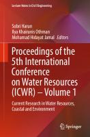
FIGURE 1.1 Schematic diagram showing the degree to which the water circulation and rock solution occur at various depths below the land surface. (From LeGrand, H.E. and LaMoreaux, P., Hydrogeology and hydrology of karst, Hydrogeology of Karst Terrains, published by Inter-national Association of Hydrogeologists with the assistance of UNESCO, Paris, 1975.) been established in the Dinaric region by drilling to a depth of 2236m, i.e., 1600m below the mean sea level. There is no distinct underground surface for the depth of the karstification process. The transition zone represents the surface below which there is no karstification. This is called the base of karstification. For the Dinaric region, the average depth of the base of karstification is not deeper than 250m. This is in contrast to 50 to 100m for eastern karst valleys of the central Appalachian Mountain region of the U.S. and 75 to 200m for western karst valleys of the central Appalachians reported by Parizek (personal communication). Depths of karstification in his study region vary with rock type, topographic setting in the valleys, structure, and related factors. They have been defined through drilling of water wells and development of metal mines, rock quarries, and limestone mines. By investigating the formation and distribution of karst porosity associated with karst springs, LeGrand and LaMoreaux [17] concluded that karstification decreases with depth and that “progressive concentration of water in the upper part of the zone of saturation produces master conduits there, but causes no appreciable increase in flow and solution at
General introduction to Karst
9
greater depths” (Figure 1.1). The solid line in the figure represents a common condition, whereas the dashed and dotted lines represent less common but not unusual conditions. Observations of the variation of karstification and permeability development versus depth have been made for a large region of Dinaric karst. The results of permeability investigations from 146 deep boreholes drilled in regions with elevations of 200 to 1000m above mean sea level have been utilized in this analysis and
FIGURE 1.2 Generalized relationship between the karstification and the depth (Equation 1.2) based on permeability tests in 146 boreholes in the Dinaric karst of eastern Herzegovina. presented in Figure 1.2 [18]. It is evident from the figure that, generally speaking, karstification decreases with depth. The zone of greatest karstification, and at the same time the highest porosity, is at the depth ranging from surface to 10 to 20m (epikarst zone). Karstification of this zone is not adequately shown on the graph because far more than 60% of boreholes within this zone were not tested for permeability. If we assume that karstification decreases with depth according to an exponential law, then =a×e−bH (1.1)
Water resources engineering in Karst
10
where is the index of karstification; H is the depth in meters; e is the natural logarithm; a and b are coefficients. For the graph shown in Figure 1.2, the variation of karstification with depth can be expressed by =23.9697 e−0.012H (1.2) It is evident from the same graph that karstification in the surface zone of 0 to 10m is about 30 times greater than at a depth of 300m. For depths greater than
FIGURE 1.3 Schematic representation of the depth of karstification: (1) Relationship between karstification and depth; (2) zone of base flow; (3) zone of water table fluctuation; (4) curve of vertical distribution of active karst porosity; (5) base of karstification; (6) curve of electrical sounding; (7) nonkarstified limestone; (8) level of water table. 300m, the index of karstification approaches its minimum value, somewhat greater than zero. The karsts of Dinarides, Helenides, and Taurides are well known for very deep karstification. The zones where the karstification extends to depths of 300 to 500m, and locally even deeper, are not very large and do not involve a considerable rock volume. This karstification is associated with tectonic zones and has been expressed in two dimensions. The highest intensity of karstification is in the aquifer section with the largest storage capacity in the zone of water table fluctuations (Figure 1.3). According to the graph, the
General introduction to Karst
11
zone with the most storage is the section of water table fluctuation. Karstification decreases below the lowest groundwater levels. The base of karstification and the minimum water table level coincide. Generally, the slope of the base of karstification leads to the zone of aquifer discharge. The most active karst channels are directly above the base level. The existence of karst drains below this level is not excluded, but they are rare and of limited transport capacities. Vlahović [19] analyzed many exploratory borings from Nikšićko Polje, Yugoslavia. He was able to prove that in the zone above the lowest levels of the water table there are 3.3 times more karst channels and caverns than in the zone below these levels.
1.6 KARST POROSITY Karst porosity consists of interconnected systems of joints, karst channels, and caverns of various shapes, sizes, and fillings. According to its origin, karst porosity can be either primary or secondary. Primary porosity is of singenetic origin, that is, it is formed at the same time as the deposition of sediments. This type of karst porosity is not very common. It occurs in greater quantity in karst aquifers in Florida (Biscayne aquifer). In the Miami region of Florida, its depth reaches approximately 33m [20]. This type also occurs on the Yucatan Peninsula in Mexico. Karst springs are formed there in 40-m-thick Tertiary limestone. Vuggy porosity represents a specific type of karst porosity, lenticular or rounded shape, ranging from intercrystalline form to decimeter-size cavities. The most common size ranges between a few millimeters and two cm. The vuggy porosity of Asmari limestone (Zagros Mountains in Iran) measured in core samples ranges between 10 to 15 and 25%. The vugs are partly connected, partly isolated, or disconnected. Larger vugs are often filled with clayey cave deposits. Sometimes they are completely plugged with calcite. This type of karstification often develops in single thick-bedded sequences. The vuggy porosity of marly limestone is very low, and is classified in four types: 1. Occasional vugs: Less than 2% of rock volume 2. Scattered vugs: 2 to 5% of rock volume 3. Vuggy: 5 to 10% of rock volume 4. Very vuggy: Greater than 10% of rock volume Karst aquifers with significant primary porosity are associated with travertine masses (Antalia, Turkey, huge travertine plateau) and with recent reef limestone. Secondary porosity consists of joints, caverns, karst channels, and cave sediments (clay, sand, gravel, and terra-rosa). This type of porosity is much more representative of karst terranes than primary porosity. Lithogenetic joints are the rarest of all types of secondary openings. However, where found, they are usually filled with sediment or are so small that they cannot be considered important water collecting and transporting media. Vlahović [21] computed porosity using the water level fluctuations in 76 bore-holes in the upper tributary area of the Zeta River in Yugoslavia. He obtained a value of 0.79%. This value represents the average porosity of a large region. Within the same region,
Water resources engineering in Karst
12
zones with much greater porosity were detected. For example, the porosity of the tectonically disintegrated limestone ridge Budoš-Kunak was found to amount to 6.07%. Torbarov [22] analyzed the effective porosity of the karst aquifer that discharges water through the Trebišnjica Springs. By using spring recession curves, the author obtained the average values of effective porosity. His calculations found the porosity of the karst water-collecting network in the karst aquifer of the springs to range between 1.2 and 1.5%. The effective porosity of the large groundwater basin of the Ombla Spring, Croatia also was evaluated by analyzing spring recession curves and water level fluctuations. This porosity varied from 1.4 to 3.5% [18]. Moore and coworkers [23] analyzed the karst region of central Tennessee. They found an average total porosity of 1.0%, which varied between 0.4 and 3.4%. The contribution of primary porosity to the total was established to be 0.6%, varying from 0.2 to 1.6%. Effective porosity values obtained on cores taken from selected dolomites gave values of less than 1 to 2% and from 1 to 20% for sandy dolomite and dolomitic sandstone beds of the Cambrian Nittany Valley of central Pennsylvania [15]. The average effective porosity of this sandy dolomite aquifer was estimated to range from 3 to 5%.
1.7 BASIC GEOMORPHOLOGICAL FEATURES The direct and most noticeable result of karstification is a specific morphology that makes karst regions quite different from any nonkarst region. Since these karst forms and their evolution are an immediate consequence of the water solution work on soluble carbonate media, the full understanding of their morphology is a prerequisite in solving a series of hydrogeological and geotechnical problems. The most representative morphological forms associated specifically with karst regions are karrens, dolines (sinkholes), dry valleys, shafts (potholes), caves, poljes, and karst plains. Karrens in limestone can reach 2 to 4m in depth and 0.1 to 1.0m in width. In some cases, their depth will exceed 5 meters. When formed along cracks, they are called cracked karrens. More often they occur in a crisscross pattern forming a network of netlike karrens. They are rare in dolomite rocks and are quite small. Kamenicas are a special group of karrens. They are small morphological forms, shallow in depth, formed on horizontal or nearly horizontal limestone surfaces. They are round or elliptical. Rarely are they deeper than 30cm. Dolines (sinkholes), aside from karrens, are the most represented morphological forms in karst. In most cases, they are the result of chemical action of water on soluble rock. This is the most important but not the only factor that influences the formation of sinkholes. The locations where two or more faults cross each other represent the most suitable starting point for karstification. Another way that sink-holes are formed is by cave-in of the roofs of caverns and karst channels located at shallow depths below the surface. The longer axis of sinkholes is frequently oriented in the direction of the longest fault, and a series of sinkholes depict the direction of the fault or fault zone. Their depths can vary from several meters to several hundred meters. The bottoms of sinkholes are usually
General introduction to Karst
13
covered with a thick layer of terra-rosa, but, although rarely, they can be without any soil cover. Under certain conditions, deep sinkholes can be filled with thick clayey sediments. The sinkhole Norin, near Nikšićko Polje (Yugoslavia) has been filled with broken rock, gravel, sand, and clay. The thickness of these sediments is about 150 meters, as shown in Figure 1.4. Cvijić [3] describes sinkholes that have been covered with white loam (Moravia), porcelain earth (the Jura region), morene materials (Dachstein), and loam with coal (lowa). In low-relief karst, the bottom of deep sinkholes is usually located below water the table. This situation was found in many sinkholes in Florida, Texas, and Alabama. In New Mexico, submerged sinkholes are located in gypsum karst. Their depths vary from 30 to 70m. They were formed by action of artesian water (according to Quinlan [24]). A number of sinkholes called obruks are concentrated in the Konya region (Turkey), at an elevation of about 1000m. Some of them formed very recently,
FIGURE 1.4 Norin sinkhole: (1) Dam; (2) stream; (3) borehole; (4) fault; (5) cave; (6) sandy-clay cover; (7) broken
Water resources engineering in Karst
14
limestone rock with sand and clay; (8) layered limestone of upper Cretaceous; (9) massive limestone of upper Cretaceous. (From Vlahović, V., Karst Nikšićkog Polja i njegova Hidrogeologija, Društvo za nauku i umjetnost Crne Gore, Podgorica, Yugoslavia, 1975.) after 1970. Many sinkholes are formed in gypsum and salt domes in the southern part of Iran. Dry valleys do not have permanent or temporary streams or rivers. Their origin is directly associated with the evolution of karstification processes that proceed at a faster rate than fluvial erosion, which is forming the valley. Lithological composition and tectonic activity have a considerable role in the formation of dry valleys. Active valleys can be changed to dry valleys where carbonate rocks are subject to tectonic uplift. Underground channels may extend to the erosion base in the upper reaches of these modified valleys beyond natural dams. Cvijić [25] analyzed the formation of dry valleys as a consequence of the development and shifting of hydrographic zones. “Karstification of limestone terrane preceded the formation of normal valleys. The critical moment in development of limestone terranes is considered to be the one when the karst erosion substitutes the normal surface erosion.” Surface water slowly sinks into joints and enlarges them at lower levels. This shifts the aquifer to deeper zones. The cracks and caves located at more shallow levels remain almost dry. Dry valleys remain on the surface. This shifting of the hydrographic process manifests itself through the superposition of more underground channel systems within the region. Downstream shifting of karst springs is also a consequence of this process. It is possible to observe a dry or occasionally active cavern above almost every karst spring. These caverns indicate an earlier evolution phase in the karst aquifer system. The formation of dry valleys in the region of a zone of concentrated solution weathering has been analyzed by Parizek [14]. His model is shown in Figure 1.5. In Figure 1.5(a), the valley has been eroded to the water table level, and a continuous supply of groundwater is established. Groundwater converges toward the valley, dissolving the underlying mass at a faster rate than for the rock located beneath the surrounding plateaus. Less permeable residual soil and transported sediments of the submerged poljes (or floodplains) contribute to the formation of springs at their contact with bedrock. The channels extend laterally and are spaced in relation to the level of submerged poljes or valley and the deep water level (piezometric line). In Figure 1.5(b), water conductors of considerable capacity develop beneath the riverbed and take over surface flow. The abandoned riverbed, dry valley, and system of channels remain. Parizek distinguishes five different elements that favor the development of karstification in the region of a valley as it forms and after it has formed: 1. Influence of geological structures and tectonic elements (joints, shear zones, faults, and interbedded joints)
General introduction to Karst
15
2. Increased river basin area (i.e., increased infiltration from temporary flows) 3. Increased outflow volume per unit volume of the rock mass 4. Seepage of floodwater into banks of the valley 5. Development of ponors, turbulent flow in the channels, and increased content of organic matter as a source of CO2 Caves and shafts are solution channels that are greater than 5 to 15mm in diameter or width. This is an effective minimum aperture for turbulent flow [2]. According to the definition given by the International Speleological Union, a cave is a natural underground opening in rock that is large enough for human entry. Shafts are vertical or subvertical karst channels. They are located within zones of vertical joints or systems that have been enlarged by karstification. Usually, they can be found on fault strikes (Figure 1.6) and at the contact between beds of limestone and dolomite. The deepest known shaft in the world is Gouffre Mirolda/Lucien Bouclier (France) at 1773m.
FIGURE 1.5 The development of regions with increased permeability and underground conductors in the vicinity of a valley and formation of a dry valley. (From Parizek, R.R., On
Water resources engineering in Karst
16
the nature and significance of fracture traces and lineaments in carbonate and other terranes, in Karst Hydrology and Water Resources, Proceedings (Dubrovnik), Zavod za hidrotehniku Gradjevinskog fakulteta, Sarajevo, 1976.) Shafts located on the periphery of karst poljes function as ponors or estavelles. Aside from chemical action, they have been subjected to intensive processes of abrasion. Hence, their entrances and channels may be of considerable dimensions and approximately circular. The diameters of these vertical channels can be as much as 10m. Caves are less frequent karst forms than shafts. Caves consist of many horizontal or gently sloping channels connected with the land surface by one or more openings. Caves, as well as all other karst channels and caverns, have been affected by faults or joints that cut across layers or interbedded joints. Furthermore, certain caves have extremely long systems of channels (Flint Mammoth Cave System, U.S., 530km; Optimisticeskaya, Russia, 153km; Holloch, Switzerland, 133km). The shafts and caves with permanent and exclusive underground flows are considered to be the most important. These flows sink substantially deeper into underground openings and passages. Caves and shafts that contain underground flows provide natural access to groundwater. These access ways are excellent substitutes for exploratory or drilled openings, but such openings are rarely used in regions where obtaining an adequate water supply is difficult. They can be successfully used to control fluctuations of the water table, to provide water sampling during tracer experiments, as well as to provide access to karst systems in areas of grouting, etc. Polje is the most prominent geomorphologic feature from a hydrogeological point of view. Its evolution is very often associated with endogenous processes within zones where rocks of different erosion susceptibility are in contact. The majority of karst poljes are predisposed by tectonics and formed and shaped by influences of exogenous factors and processes. The poljes can be found in the Dinaric karst region, on the Adriatic Islands in Greece (Peloponnesus and Crete), in the Taurus region of Turkey, and in Canada, China, Iran, Jamaica, and the U.S. Common characteristics of poljes (Figure 1.7) are: • They have a flat quaternary cover surrounded with a karstified carbonate rock mass that extends far above the level of the polje. • In some cases they are elongated in shapeand their longer axis matches the stratigraphic and structural strike of the carbonate rock mass. • Springs, estavelles, and ponors are typically presented along their perimeters. • Usually a temporary (very rarely a small permanent) stream is formed between the most important spring and ponor, and this stream shows considerable variation in its flow. • Alluvial ponors (subsidence ponors) are often found in quaternary sediments. • During dry periods the water table is deep below the paleorelief of the polje.
General introduction to Karst
17
FIGURE 1.6 Connection of karst forms with fracture tectonics: (1) Fault; (2) fractured zone; (3) bedding trace; (4) cliff; (5) direction of underground flows; (6) ponor; (7) estavelle; (8) intermittent spring; (9) sinkhole (doline). If poljes are surrounded along all sides by mountain masses, they are called enclosed poljes. The major characteristics of an enclosed polje are the exclusive underground inflow and underground outflow of surface water. However, if there is surface inflow, that polje is known as an upstream open polje. A polje with surface outflow is called a downstream open polje. Also, the polje can be open both upstream and downstream. In the Dinaric karst region there are approximately 130 poljes. The total area of all those poljes is about 1350km2. Drainage of surface water is achieved through many ponors. These are frequently located in the polje areas nearest to the prevailing erosion base. In Nikšićko Polje, about 880 ponors and estavelles were identified, 851 of which are located along its southern perimeter [19]. In Popovo Polje, there are more than 500 ponors and estavelles.
Water resources engineering in Karst
18
Poljes become flooded as soon as the sink or recharge capacity of the ponor becomes lower than the inflow quantity of water. Natural plugging of ponors may also lead to faster flooding and longer duration of floods. Flood duration can vary considerably. Annual flooding in Fatničko Polje, Herzegovina lasts between 79 and 213 days, and the highest water level can be as much as 38m above the polje’s lowest point. Flooding of Popovo Polje under natural conditions (before the Trebišnjica hydroelectric power system has been built) reached a water depth of 40m in the lowest section of the polje. During the years of that occurrence, the polje was under water an average of 253 days per year and was dry only 112 days. During maximum flood, 7500 hectares were under water. The longest floods in Popovo Polje were observed in 1915 (303 days) and in 1937 (271 days). The area of Nahanni (Nahanni karst) in the subarctic region of Canada contains the most northern karst poljes. Between large depressions (more than 100m deep and up to 1000m in length), the highest karst is permafrozen and relict [26].
FIGURE 1.7 Fatničko Polje, Herzegovina: (1) Tapped spring; (2) permanent spring; (3) temporary spring; (4) great temporary spring Baba; (5) estavelle; (6) largest
General introduction to Karst
19
estavelle Obod; (7) ponor; (8) group of near ponors; (9) great ponor; (10) big cave; (11) shaft; (12) sinkhole; (13) temporary riverbed; (14) overthrust front; (15) fault; (16) Eocene sediment of flysch; (17) Eocene limestone; (18) karstified Cretaceous limestone. Lasithi Polje in Crete is a typical closed polje with a huge ponor in the lowest part. The bedrock is covered with 30 to 40m of sandy gravel deposits containing a large aquifer. From that aquifer more than 10,000 dug wells are in operation for water extraction. At the Central Peloponnesus (Greece) six temporary flooded poljes are concentrated at elevations between 500 and 700m: Feneos, 700 to 710; Levidi, 670 to 680; Tripolis, including Taka Lake, 630 to 660; Kandila, 630 to 640; Stymfalia, 600 to 620; and Skotini-Alea, 530 to 550. Many medium and large poljes can be found in karst terranes of Turkey, especially in the Taurus Mountain range (Enif, Gembos, Sobuca, Mugla, and Kastel). The Arzhan Lake polje in Iran is located at an altitude of 1990m in the Zagros Mountains near Shiraz. The main inflow is through the Arzhan Spring (Qmax≈750 l/s; Qmin100
50
2800
—
Matali, Papua New Guinea
20
>240
90
350
—
Vaucluse, France
4.5
200
29
2100
—
Tisu, China
4
545
38
1004
0.4–39
Timavo, Italy
9
130
17.4
980
—
Trebišnjica, Herzegovina
2
>300
80
1144
—
Ombla, Croatia
2.3
154
33.8
600
12–14.8
Ljubljanica, Slovenia
4.25
132
39
1100
—
Buna, Herzegovina
2.95
123
23.7
112
—
Bunica, Herzegovina
0.72
207
20.2
512
—
4
390
33
1040
—
15.3
36.5
23.25
1900
—
6
515
28
>1000
—
Coy, Mexicoa
13
200
24
>1000
—
Sinjac (Piva), Yugoslavia
1.4
154
21
505
—
Sette Comuni, Italy
≈1
105
14
—
8.3–9.5
Grab-Ruda, Croatia
2
105
20
385
—
Vipava, Slovenia
≈1
50
—
150
8–10
10–15
35
22–27
—
16.2
Riječina, Croatia
1.2
80
12.4
330
—
Karuč, Yugoslavia
1.9
>50
7
120
7–12
Dumanli, Turkey a
a
Chingshui, China Silver, U.S.
a
Frio, Mexico
a
Kirkgozler, Turkey
General introduction to Karst
Bregava, Herzegovina
21
0.45
59
17.5
396
—
2–3
23
8.5
—
—
5.3
21
15
450
—
1
45
13.5
730
—
Kuhrang, Iran
0.7
12
3
—
–
Perućac, Yugoslavia
0.4
9
1.2
67
—
Sasan, Iran
0.9
12
—
—
—
Mlava, Yugoslavia
0.72
17
1.7
120
9–10
Al-Sinn, Syria a
Waikoropupu, New Zealand a
Maligne, Canada
a
See Ford, D. and Williams, P., Karst Geomorphology and Hydrology, Unwin Hyman, London, 1989.
• Lilburg Cave-Big Spring, U.S.: Surveyed by divers down to 53.5m (continues further in depth) • Manatee Springs, U.S.: Investigated 30m in depth and 2088m in length • Ombla Spring, Croatia: Detected by boreholes 130 to 140m below sea level (surveyed by divers down to 54m below sea level; Figure 6.8) • Krupac Spring, Yugoslavia: Surveyed by divers down to 86m • Wakulla Springs, U.S.: Surveyed by divers down to 87m • Krupaja Spring, Yugoslavia: Surveyed by divers down to 72m • Mlava Spring, Yugoslavia: Surveyed by divers down to 73m • Spila Risanska, Yugoslavia: Temporary spring, surveyed by divers down to 52m, horizontal 300m (continue further in depth) • Gornjepoljski Vir, Estavelle, Yugoslavia: Surveyed by divers down to 63m
FIGURE 1.8 Ponikva Ponor on the perimeter of Dabarsko Polje, Herzegovina. 1.9 PONORS (SWALLOWHOLES)
Water resources engineering in Karst
22
Ponors are one of the symbol features of karst regions, and crucial features from a hydrogeological and geotechnical point of view. The problems of reservoir and dam-site watertightness or structure stability are almost always connected with the presence of different types of ponors. Ponors develop subsequent to the formation of joint systems, faults, and bedding plane partings that become enlarged through chemical and mechanical actions of water to which carbonate rock masses are subjected. Often, ponors are located along the periphery of karst poljes and alongside riverbanks. Their locations along the outer boundaries of poljes (Figure 1.8) depend upon the position of the lower base level of erosion. Most ponors are found along the portion of poljes peripheral to areas that are nearest to the base level of erosion. Different parameters can be used when classifying ponors. According to their swallowing capacity, the ponors are divided into two groups: permanently active and temporarily active. The second group is more numerous. Ponors can be divided into four basic groups based upon their surface appearance. The first group consists of ponors with shapes of big shafts and caves; the second includes ponors resembling big and enlarged cracks and small caverns; the third group consists of ponors with a system of narrow joints; and the fourth includes subsidence or collapse types developed by breakdown processes in alluvium coverage. The most important subdivision from a hydrogeological standpoint is their recharge capacity. In most cases, this subdivision is in agreement with the previous classification because their recharge capacity depends upon the capacity of connecting karst channels. The position of the groundwater level in the karst aquifer containing these channels can also reduce the recharge capacity of the ponor almost to a minimum. In some cases, ponors with large openings may have only a small recharge capacity. Furthermore, it is possible for their recharge activity to become temporarily lost. Ponors with continuous and constant recharge capacity are rare. Ponors with a recharge capacity of more than 1m3/s are included in the first group. These ponors are directly linked to both surface and underground drainage systems. Commonly, they are located along the outer boundaries of karst poljes and along the banks of temporary and permanent rivers. In the Dinaric karst region there are ponors with huge swallowing capacity. The capacity of Slivlje Ponor in Nikšićko Polje (Yugoslavia) is about 120m3/s. Biograd Ponor in Nevesinjsko Polje (Herzegovina) is one of the largest ponors known. It has a capacity of at least 110m3/s. Srdevići Ponor in Gatačko Polje (Herzegovina) swallows about 65m3/s. Kovači Ponor in Duvanjsko Polje (Bosnia) has an extraordinary entrance 25m wide and 15m high. It has a swallowing capacity of more than 60m3/s. The swallowing capacity for Doljašnica Ponor in Popovo Polje (Herzegovina) exceeds 55m3/s. The swallowing capacity of Ponikva Ponor (Figure 1.8) on the perimeter of Dabarsko Polje (Herzegovina) is about 20m3/s. Ponors of the second group have recharge capacities between several tens of liters per second and 1m3/s. These ponors are common alongside banks of intermittent rivers. Usually they consist of enlarged cracks or caverns, sometimes filled with large rock blocks. Ponors and ponor zones consist of systems of narrow cracks and are commonly located within intermittent rivers and on the slopes along the karst poljes. When located in riverbeds, they are covered with gravel and pieces of broken rock of variable sizes. When found along the karst poljes, they are represented by cracks and karrens of
General introduction to Karst
23
different shapes. They cannot be identified during the dry season because there is no way to distinguish them from their surroundings. The fourth group consists of ponors in the form of subsidences originated in alluvial deposits that cover polje bottoms, riverbanks, and sinkhole (doline) bottoms. In fact, these are only the surface shapes of ponors that extend in karstified carbonate rock located below alluvial overburden deposits. Commonly they are funnel shaped with dimensions varying between very small (a few centimeters in diameter) and large (depths of 10 or more meters), as well as with diameters of about 15 to 20m. When ponors become plugged near the surface, new ones usually open in the vicinity of old ones.
1.10 ESTAVELLES Estavelles are phenomena with dual hydrological functions. The name was derived from Estavelle in the French Jura, a mountain range between France and Switzerland. witzerland. Depending upon the position of the groundwater level and hydrological conditions on the surface, an estavelle can function at one time as an intermittent spring and at another as a ponor (swallowhole). From a morphological point of view, estavelles are represented in the shape of intermittent springs and ponors. They are part of the karst drainage system. The principal function of estavelles is shown in Figure 1.9. The situation during the dry season is presented in stage (a) of the schematic cross-section. The groundwater level in Figure 1.9 (9) is very low so that a spring (2) exists only at the seacoast (1). Two upper erosion bases (4 and 7) are without flows and springs. During the wet season (b, 12) the groundwater level rises. When the groundwater level meets
FIGURE 1.9 Principal operation of estavelles: (1) Mean sea level; (2) location of coastal discharge of karst aquifer; (3) ponor zone; (4) lower karst polje; (5) estavelle zone; (6) ponor zone of upper karst polje; (7) upper karst polje; (8) spring zone of upper karst polje; (9) aquifer water level;
Water resources engineering in Karst
24
(10) direction of groundwater circulation; (11) estavelle function as a spring; (12) precipitation; (13) groundwater flow from a ponor; (14) floodwater level within a polje. the surface of terrain within the estavelle zone (5), an estavelle becomes a spring. Furthermore, the inflow of surface water for a longer period of time activates (6) is activated, causing the water inflow increases on the lower erosion base, that intermittent springs on the highest erosion base (c, 8). At the same time, the ponor is, in the enclosed karst polje. Since the ponor capacity (3) is not sufficient to discharge all inflowing water, the polje is flooded (14). As long as the groundwater table is at the same level as the land surface or above it, the estavelle functions as a spring that in the initial stage has a free outflow. However, under submerged conditions, it functions as a sublacustrian spring. With a decrease in precipitation (d), lowering of the groundwater table starts, and the estavelle begins to function as a ponor instead of as a spring. The estavelle functions as a ponor until there is enough water inflow available for recharge.
1.11 SUBMARINE SPRINGS Submarine springs are found under sea level. Their near coast location and operation are schematically shown in Figure 1.10. They are visible at the sea surface as a circular area that appears different from surrounding seawater. Submarine springs were formed during a continental phase when the base of erosion was lower than at present. Submarine springs have been discovered at many localities: in the Mediterranean region along the coasts of Croatia, France, Greece, Israel, Italy, Lebanon, Libya, Spain, Syria, Turkey, and Yugoslavia; in the Persian Gulf (Bahrein); and along the coasts of the Bahama Islands, Barbados, Cuba, Jamaica, and Japan; the Yucatan Peninsula in Mexico; and the Black Sea.
FIGURE 1.10 Various cases of groundwater discharge in a karst aquifer near the absolute base of erosion: (1) Submarine springs; (2) intermittent spring at sea level; (3)
General introduction to Karst
25
intermittent spring active only during periods of high water table; (4) aquifer water table. Submarine springs have attracted attention because of their high capacities and considerable quantities of freshwater, usually in the regions where potable water is in short supply. In ancient times the Phoenicians drew potable water from the sea bottom by closing the openings of submarine springs. These flows of freshwater were tapped using a lead funnel that was connected to a network of pipes. One of the best known successful tappings of submarine springs was performed in Trieste Bay. The water was tapped near the coast and has been used only for industrial purposes. This example may be considered as a special case where a submarine spring was tapped for supplying water. However, many more cases might be reported that were not so successful.
1.12 SUBSIDENCE AND COLLAPSE An important and quite special problem in karst is the formation of subsidences (collapses). The terms subsidence and collapse usually are used as synonyms. The terms sinkhole and doline refer only to localized land surface depressions arising from karst processes [27]. Subsidences are spatially independent, random occurrences and have been identified as sources of major potential problems, which may cause considerable damage in reservoir bottoms, in urban areas, at industrial sites, and near communication lines. The catastrophic nature of subsidence development is unpredictable and practically instantaneous and therefore very harmful. Subsidence is common when karstified rocks are covered with unconsolidated sediments. This occurs under the influence of water, as the erosion and piping action breaks down the support of poorly consolidated sediments. The destructive role of water can be distinguished in four different categories: • • • •
Underground water acting from below Surface water acting as floodwater Pore water within alluvial deposits (overburden) Water acting indirectly, pressurizing the air in the aeration zone
The genesis of subsidences is usually related to these categories of processes.
Water resources engineering in Karst
26
FIGURE 1.11 Formation scheme of subsidence: (1) Flood level; (2) groundwater level; (3) unconsolidated alluvial deposits; (4) carbonate rocks; (5) direction of groundwater flow; (6) filtration direction of floodwater; (7) karst channel. A generalized and simplified model describing those processes is shown in Figure 1.11. Initially, the conduit opening (ponor) was formed by karst processes acting within carbonate rocks or in other rocks susceptible to karstification. During the process of sedimentation, the opening was covered with deposits of clay, terrarosa, sand, gravel, cobbles, and boulders. Under the influence of moving water, the process of mechanical suffusion destroyed homogeneity of unconsolidated deposits. As a result of this destruction, a relaxation zone formed, shaped approximately as an arch, semi-ellipse, or parabola (I). This surface will remain unchanged as long as external forces are in equilibrium with resisting arch forces. Internal friction, specifically shearing resistance along vertical planes, plays an important role in maintaining this equilibrium profile. However, surface waters, groundwaters, or pore waters essentially change the cohesion and angle of internal friction of the soil, and a new load release surface is formed (II) according to the new state of equilibrium. Part of the material between spherical surfaces (arches) (I and II) will subside into caves and be transported by water further away in the karst system. When the roof of the spherical surface approaches ground surface, the entire roof caves in, thus producing a circular opening on the land surface (alluvial ponor).
General introduction to Karst
27
Origins of subsidences can be natural or induced. Induced subsidence is a consequence of the urbanization, mining, reservoir construction, and groundwater extraction that dramatically increased in the second part of the twentieth century. According to LaMoreaux and Newton [28], thousands have been formed in the U.S. since 1950. More than 80% of the identified events are a consequence of uncontrolled exploitation of underground water. According to the United States Geological Survey (USGS), in 1991 the national Research Council estimated that annual costs in the U.S. from flooding and structural damage caused by land subsidence exceeded $125 million [28a]. Indirect costs are many times higher. The magnitude of subsidence caused or accelerated by human activities can be catastrophic. These occurrences are well documented in the literature, especially in publications of Chinese and American geologists. Intensive pumping of karst aquifer in Florida recently provoked formation of 650 subsidence features over a relatively short time. According to Brink (in [2]), after 25 years of pumping in a gold mining district in South Africa, 38 people had lost their lives in mine collapses, and damage to buildings and structures was enormous. In one event, 29 men lost their lives when a three-story building collapsed. Construction activities triggered a number of subsidences in Alabama. According to Hua [29], subsidence due to groundwater pumping was reported from 25 areas in China during the period 1974 to 1986. In one extreme case, 600 subsidences were recorded in an area of 5km2. The maximum reported subsidence density in China is greater than 500 per 0.1km2. The largest subsidence event occurred in Sichuan Province, a structure 400m in diameter and 176m in depth [30]. Subsidence (collapse) development is also a very common process that endangers the safety and integrity of dams and reservoirs. Commonly induced collapses result from water table drawdown due to dewatering by sub-surface mines, recessed quarries, and wells. Subsidence induced by extensive water level fluctuation in man-made reservoirs has resulted in considerable leakage from certain reservoirs (Mavrovo Reservoir, FYR Macedonia: 7m3/s; Vrtac, Nikšićko Polje, Yugoslavia: 25m3/s; Hutovo Reservoir, Bosnia and Herzegovina: 3m3/s, Perdika Reservoir, Greece; May Reservoir, Turkey; Kamskaya Dam, Russia; North Dike, Florida; Huoshipo Reservoir, China). The process of piping (Figure 1.12) together with air pressure (Figure 1.13) and water uplift can trigger subsidence ponors and produce huge leaks in reservoirs. Sometimes piping takes many years to happen, but most subsidence ponors occur during the first impounding of a reservoir. Protective measures against ponor creation at the bottom of reservoir are inverted filters, clay blankets, nonreturned valves, aeration tubes, PVC foils, reinforced shotcrete blankets, and in special cases, grouting of karstified bedrock. Nonreturned valves and aeration tubes are very important measures to protect different type of blankets against the destructive effects of groundwater uplift and air pressure attack. An important role is played by air under pressure in the formation of subsidence and subsidence ponors. During dry seasons (Figure 1.13A) the caverns fill with air above the water table level within the aquifer. Short periods of heavy precipitation lead to flash flooding of the water table. Air becomes trapped in some caverns, which are interconnected with cavities, and other weak areas where conduit openings are plugged. This air does not have enough time to escape because the surface layer of soil is rapidly
Water resources engineering in Karst
28
saturated with water. Therefore, air becomes entrapped and pressurized (Figure 1.13B). When pressurizing forces exceed the strength of the material, failure occurs in the section of alluvium directly above the compressed zone. This is almost always followed by an effect similar to an artesian well—eruption of water. After
FIGURE 1.12 Schematic presentation of the most important phases (1 to 5) in collapse formation at the bottom of a reservoir.
FIGURE 1.13 Formation scheme of subsidence ponors under the influence of pressurized air: (1) Floodwater level; (2) alluvial sediments; (3) karstified carbonate rock; (4) groundwater table. achieving equilibrium and when the water table begins to fall, the ponor starts to drain the water (Figure 1.13C). More information can be found in [27, 28, 28a]. Human activities can also play a special role in inducing or enhancing karst processes in evaporite rocks, and the results can be catastrophic [31]. Owing to the extremely high
General introduction to Karst
29
and rapid dissolution process, the formation of the initial cavity (collapse), deep below the surface, and its migration upward to the land surface occur much faster than the same process in carbonate rocks. According to Johnson [31], the gypsum-karst problems are caused by the following human activities: • Building structures that induce differential compaction of soils above an irregular gypsum-bedrock surface • Building structures directly upon gypsum-collapse features • Impounding water above or directing water into a gypsum unit where soil piping can divert water (and soil) into underground gypsum cavities Detailed information related to the occurrence and characteristics of the rock and mineral gypsum, its highly soluble nature and the types of problems associated with it are presented in Cooper and Calow [32]. Induced collapses in salt deposits are usually associated with solution-mining and petroleum industries. The size of collapse varies between 10 and 100m in diameter and 10 and 600m in depth. Hundreds of collapses have occurred along the Dead Sea coast (Israel and Jordan) as a consequence of constant drawdown of the level of the Dead Sea (60 to 80cm per year). Numerous collapses also endanger long dikes in the southern part of the Dead Sea; the foundations of those dikes are constructed over thick and very soluble salt deposits.
References 1. Gušić, B. and Gusić, M., Kras Carsus Iugoslaviae, Academia Scientiarum, Zagreb, Yugoslavia, 1960. 2. Ford, D. and Williams, P., Karst Geomorphology and Hydrology, Unwin Hyman, London, 1989. 3. Cvijić, J., Karst: Geografska Monografija (Karst: Geographical Monograph), Beograd, Yugoslavia, 1895; first edition: Karstphanomen, Wien, 1893. 4. Jennings, J.N., Karst, Australian National University Press, Canberra, 1971. 4a. U.S. Environmental Protection Agency, National Center for Environmental Assessment, A Lexicon of Cave and Karst Terminology with Special Reference to Environmental Karst Hydrogeology, Washington, D.C., 2000. 5. Cvijić, J., Geomorfologija (Morfologie Terrestre), Tome Secondo, Beograd, Yugoslavia, 1926. 6. Komatina, M., Conditions of Karst Development and Zoning of Karst Terranes, Vesnik Geozavoda X/XI, Beograd, Yugoslavia, 1973. 7. Herak, M., Geological approach to classification of terranes for consolidation treatments, in Proceedings, I JUSIK 76, Zagreb, Yugoslavia, 1976. 8. Milovanović, B., Epirogenic and Orogenic Dynamics in the Region of the Outer Dinarides and Problems of Paleokarstification and Geologic Evolution of Holokarst. Vesnik Geozavoda, IV/V, Beograd, Yugoslavia, 1964/65. 9. Quinlan, J.F., Karst-related mineral deposits and possible criteria for the recognition of paleokarst: A review of preservable characteristics of holocene and older karst terranes, in 24th IGC, Section 6, Montreal, Canada, 1972. 10. White, B.W., Role of solution kinetics in the development of karst aquifers, in Karst Hydrogeology, Tolson, J.S. and Doyle, F.L., Eds., UAH, Huntsville, AL, 1977. 11. Castany, G., Traite Partique des Eaux Souterraines, Ed. Dunod, Paris, 1963. 12. Corbel, J., Les karsts du Yucatan et de Florida (The karst of the Yucatan and Florida), Bull. Assoc. Geograph., France, 1959.
Water resources engineering in Karst
30
13. Lehmann, O., Die Hydrographie des Karsts (Hydrology of the karst), in Enzyclopadie der Erkunde, Deuticke, Leipzig, Germany, 1932. 14. Sokolov, D.S., Osnovnie Usloviya Razvitiyia Karsta (Main Conditions of Karst Development), Gosgeoltehizdat, Moscow, 1962. 15. Parizek, R.R., Sustained Yield of Wells in Fractured Carbonate Rocks, Circular 82, Mineral Conservation Series, Pennsylvania State University, 1971. 16. Parizek, R.R., On the nature and significance of fracture traces and lineaments in carbonate and other terranes, in Karst Hydrology and Water Resources, Proceedings (Dubrovnik), Zavod za hidrotehniku Gradjevinskog fakulteta, Sarajevo, 1976 (in Serbo-Croatian). 17. LeGrand, H.E. and LaMoreaux, P., Hydrogeology and hydrology of karst, Hydrogeology of Karst Terrains, published by International Association of Hydrogeologists with the assistance of UNESCO, Paris, 1975. 18. Milanović, P., Karst Hydrogeology and Methods of Investigation, Institute for Karst Water Utilisation, Trebinje, 1979 (in Serbo-Croatian). 19. Vlahović, V., Karst Nikšićkog Polja i njegova hidrogeologija (Hydrogeology of Karst Region of the Nikšićko Polje), Društvo za nauku i umjetnost Crne Gore, Podgorica, Yugoslavia, 1975. 20. Stringfield, V.T., Artesian water in tertiary limestone in the southern states, Professional paper 517, USGS, Washington, D.C., 1966. 21. Vlahović, V., Porosity in the karst catchment of the Gornja Zeta River, in Geološki Glasnik, Vol. VI, Titograd, Yugoslavia, 1970. 22. Torbarov, K., Estimation of permeability and effective porosity in karst on the basis of recession curve analysis, in Hidrologija i vodno bogatstvo krša, Zavod za hidrotehniku, Sarajevo, 1976, p. 97. 23. Moore, G.K., Bruchett, C.R., and Bingham, R.H., Limestone Hydrology in Upper Stones River Basin, Central Tennessee, Tennessee Department of Conservation, Division of Water Resources and USGS, Washington, D.C., 1969. 24. Quinlan, J.F., Hydrology of the Turnhole Spring Groundwater Basin and Vicinity, West Kentucky University, Bowling Green, 1976. 25. Cvijić, J., Underground hydrology and morphological evolution of karst. Special edition of the Serbian Geographical Society, Vol. 35, Beograd, Yugoslavia, 1957 (reprint of 1918 edition, Grenoble, France). 26. Brook, G.A., Surface and groundwater hydrology of a highly karstified subarctic terrain in northern Canada, in Karst Hydrogeology, Tolson, J.S. and Doyle, F.L., Eds., University of Alabama, Huntsville, 1977. 27. Back, B.F., Sinkhole terminology, in Proceedings of the First Multidisciplinary Conference on Sinkholes, Back, B., Ed., A.A.Balkema, Rotterdam, 1984. 28. LaMoreaux, P.E. and Newton, J.G., Catastrophic subsidences: An environmental hazard, Shelby County, Alabama, Environ. Geol. Water Sci. 8(1/2), 25, 1886. 28a. USGS, Land subsidences in the United States, Circular 1182, U.S. Department of the Interior, 1999. 29. Hua, S.L., Pumping Subsidences of surface in some karst areas of China. Symposium on human influence on karst, Postojna, Yugoslavia, 1987. 30. Shouyue, Z., Karst subsidence in China, in Sinkholes: Their Geology, Engineering and Environmental Impact, Back, B.F., Ed., A.A.Balkema, Rotterdam, 1984, p. 97. 31. Johnson, K.S., Evaporite karst in the U.S., Carbonates Evaporites, 12(1), 2, 1997. 32. Cooper, A.H. and Calow, R.C., Avoiding gypsum geohazards: Guidance for planning and construction, Technical report WC/98/5, British Geological Survey, 1998.
2 Groundwater in Karst The plateau of the western Balkans is the classical area of limestone physiography. From it comes the word karst and other terms which are slowly invading English and American geological literature. —A.C.Swinnerton
Ancient mill at the Trebišnjica River bank, Herzegovina
Water resources engineering in Karst
32
2.1 BASIC THEORIES ON KARST GROUNDWATER CIRCULATION Circulation of groundwater through karstified rocks is quite different from circulation through nonkarst terranes. This circulation is a specific hydrogeological characteristic of karst terranes. Almost all underground and surface phenomena in karst are, by their origin, related to the presence and circulation of water. Interest in obtaining a detailed understanding of all kinds of water occurrence and movement in karst regions has existed for a long time. In contrast to other geological terranes, it is more difficult to establish the relationships that govern the circulation and storage of water in karst terranes. For this reason, all scientists who studied karst formulated theories based on their own specific experience that are in many instances either opposite or controversial. The best-known theories were established at the beginning of this century. The authors of these theories were Grund [1], Katzer [2], and Cvijić [3]. According to the theory of the geographer Alfred Grund [1], there is a uniform waterbearing horizon in karst: the aquifer. He separates two zones of underground water: stagnant zone and karst water. Stagnant water does not move since it occurs in cracks and caverns of karstified rocks located at great depths. The water table of this stagnant zone gently slopes toward the sea. Above this zone is a zone of moving (flowing) water which Grund named karst water. Its free surface also dips toward the zone of outflow that is the sea, but at a much higher rate than the dip on the stagnant water table. The Austrian geologist Friedrich Katzer [2], in contrast, believed that the flow of groundwater in karst terranes takes place predominantly through systems of caverns and channels. According to Katzer, there are underground water courses through karst channels, cracks, and caves that are “at one instant interweaved and branched out, and oddly interconnected at another instant independent from one another.” According to Katzer, separate systems of underground flows, which are also areas of chemical erosion, prevail in deep karsts where development of the karst process has not reached the impermeable base. Jovan Cvijić [3] contemplated three hydrographical zones with different types of circulation and considered them to be a direct consequence of the evolution of the karst process. Those three zones are (1) dry, (2) transitional, and (3) zone with continuous circulation of water. The dry zone is located directly below land surface. It is characterized by an abundance of dry caves, channels, and cracks through which water moves almost vertically downward toward the transition zone. Groundwater may flow in some of these channels and caves during rainy seasons. The transitional zone is characterized by permanent and periodic hydrological phenomena. During periods of precipitation, percolation of water into deeper portions of the carbonate rocks is either slowed down or completely terminated within this zone. Groundwater is concentrated in this zone where active flow takes place. The transitional
Groundwater in Karst
33
zone is located above the bottoms of karst depressions. During rainy seasons, the development of springs is a characteristic of these depressions. The zone containing continuously moving water is located beneath the level of karst depressions. A substantial quantity of water from this zone flows in the direction of the water table. Thus, water movement is slowed down. This zone contains scattered enlarged cracks, and the phenomenon of siphonal circulation is often encountered. Since the aquifer discharge capacity is reduced, groundwater levels rise during heavy precipitation when the size of this zone is increased at the expense of the transitional zone. A similar relationship exists between the transitional and dry zones. These three zones are not clearly distinguished, and their position can be changed. They closely follow the evolution of the karst process and move downward, one at the expense of the other. During the process that causes each zone to be lowered, the surface of the terrane is also being lowered due to denudation. In the last phase of development, only the dry zone remains in the lowered karst. Super-position of these zones is always dependent upon geological structures. They are expressed less in shallow karst and more in deep karst. Cvijić’s theory [3] has been accepted by many researchers as being closest to reality.
2.2 KARST AQUIFER Karst aquifers are nonhomogeneous underground reservoirs in which water collects in networks of interconnected cracks, caverns, and channels. The free-water table of the aquifer is not a well-defined continuous surface. It has a regional as well as local dips. In general, the entire aquifer dips toward the base of erosion, where water drains from the collector under the influence of this base level. The position of the base of erosion is an essential factor in the determination of the dominating direction of underground circulation. Lithology, faults, and structures are also very important directors or controllers of underground water flow, but their function is essentially less important than the role of the base level of erosion. With respect to its importance in the formation of hydrogeological characteristics of karst regions, the base of erosion can be divided into three groups. The first group includes the absolute erosion base level. These are the sea basins, specifically the zones between the sea level and the deepest submarine springs occurring in the region. The second group includes the major erosion base levels for continental regions. These are deepest river valleys and canyons. The third group contains local erosion base levels. These are karst poljes, river valleys of higher elevation (dry or with flow), dolines, etc. Local base levels have effects on small regions and are always used for conveyance of the temporarily stored water. From a karst development standpoint, these bases are very important because they have a considerable influence on regulating the evolution of karst aquifers. Figure 2.1 describes schematically the most important zones in the region of absolute erosion base level (sea). The storage of water and the formation of an aquifer zone occurs in zones B and C (base flow zone), where water movement and outflow occur under the influence of gravity. In zone D, only siphonal circulation is possible. In zone E,
Water resources engineering in Karst
34
groundwater is brackish. In zone F, freshwater is completely substituted by salty water. A nonkarstified rock mass, zone G, is located below the
FIGURE 2.1 Circulation scheme in the coastal part of a karst aquifer: (A) Aeration zone; (B) zone of dynamic reserves with fast water exchange; (C) part of aquifer with slow water exchange; (D) zone of siphonal circulation; (E) zone of brackish water; (F) zone of salty water; (G) zone beneath the base of karstification. karst collector. This zone does not store substantial quantities of free groundwater. The upper boundary of zone G is called the base of karstification. This boundary is not well defined and can be considered a transitional zone between karstified and nonkarstified rocks. Karst conduits with high transmission capacities represent local levels of erosion for the surrounding rock mass where fracture-type porosity predominates. Water tables or piezometric surfaces are formed and frequently change under the influence of these local base levels. Thus, the water levels observed in piezometric boreholes essentially depend on the conditions that exist within the nearest water-filled conduits. Figure 2.2 shows schematically a change of piezometric line under the influence of three drains located at various elevations. During the highest groundwater stage shown as piezometric level I, water table location depends upon the capacity of a drain as revealed by the piezometer located nearest to the drain. The water level in this piezometer will be at a greater depth than the free-water surface. It will be deeper (hI) in piezometer 1 than in piezometer 6 (h′I). Alteration of ∆H of the piezometric line can also be observed in piezometer 4 since this piezometer is directly connected with drain b, which contains actively flowing water and is thus under its hydraulic influence. Instead of the expected level H, the level H+∆H will be measured at this greater depth. The piezometric line is altered locally as indicated by position Ia. At this time, piezometer 4 acts as a drain for the part of the aquifer in its immediate vicinity.
Groundwater in Karst
35
By further lowering of the water table level, drain b also gradually begins to function as the dominating erosion base level. At one moment, the piezometric line assumes position II. In piezometric borehole 5 the effect of drain c (base flow) starts to be recognized so that the measured level in this piezometer is deeper for h than the expected groundwater level h. The measured water level is observed at depth h +∆h. The effect of drain c on piezometer 5 is not directly connected to the existence of drain b.
FIGURE 2.2 Position of piezometric line in a karst aquifer. Finally, under the influence of drain c the piezometric line III is formed and is quite different from the previous line. The measured level in piezometer 1 (hIII) is now considerably higher than in piezometer 6 (h′III) because it is closer to the momentarily actual base of erosion.
2.3 EVOLUTION OF KARST AQUIFERS Karst aquifers develop in response to dynamic phenomena that operate in time and space. Their geometry changes very rapidly, which in turn changes hydrodynamic regimes of the aquifers. All of these changes represent a uniform process: the evolution of karst aquifers. Karst aquifer evolution is based on the tendency of karsts to adjust their water level to the zone of discharge in reference to the base of erosion [4]. That water trend is directed at first to the nearest base of erosion. As soon as this base level is reached, the process continues further insofar as there is another lower base of erosion. By lowering the groundwater level within the aquifer to a greater depth, channels of higher elevation begin to lose their permanent function in the drainage system. The highest channels remain constantly above groundwater level, and stalactites and stalagmites start to form in them.
Water resources engineering in Karst
36
Epirogenic movements govern this competition, which is reflected in changes in hydrogeological watersheds and shifting of terminated drains. As a consequence of this karst evolutionary process, groundwater levels continuously are being lowered, often to the sea level, through a rearrangement of surface drainage systems. In the final stage of this evolution, the surface drainage system completely disappears.
FIGURE 2.3 Model of transformation of separated karst aquifers into a single aquifer: (Left) Cross-section. (1) Direction of groundwater flows; (2) groundwater flows in single aquifers; (3) highest level of water table; (4) nonkarstified rock mass; (5) permanent surface water flow; (6) seasonal surface water flow; (7) base of karstification; (8) main spring; (9) ponor (swallowhole). (Right) Schematic layout. Temporary river flows, dry valleys, and periodically flooded poljes are the only phenomena that remain at the surface. The karst process destroys the individual surface drainage systems under some geological conditions; it connects them and transforms them into one single catchment area. Under some other tectogenic conditions, this process destroys vast water-abundant surface catchment areas and creates from them a few smaller karst catchment areas. The generalized scheme of transformation processes from several separate aquifers into a single aquifer is presented in Figure 2.3. As a consequence of differential movements of separated tectonic blocks, the zones of concentrated infiltration are formed in cascades. Each of these zones of the poljes (from I to IV) represents an erosion base of
Groundwater in Karst
37
a separate aquifer in the initial phase of karst aquifers formation. The karstification reaches the deeper parts of the rock mass below the erosion base, adapting itself to the lowest discharge zone. It connects them into a complex hydrogeological entity, provided the karstification intensity increases from higher levels down to the lower erosion bases. The close genetic relationship of geomorphology and neotectonics with the evolution of karst aquifers emphasizes the importance of morphometric techniques [5,6]. According to Marković [5], the work on full geomorphological analysis can be separated into five steps. The first step is the general inspection of the terrane. The second step includes the analysis of aerial photographs and topographical maps. The third step is composed of the major investigation work in the field, consisting of verification of results derived in the office based on compiled data required to support hypotheses. The fourth step includes the office research in order to establish the cause of tectonic movements and its relationship with the relief evolution. The fifth step represents the last check of the feasibility of proposed concepts and accuracy of geomorphological analysis for the area under investigation.
2.4 FLUCTUATION OF THE WATER TABLE The large dimensions of karst channels, their good interconnections, high water level gradients, and the high permeability of surface zones enable fast filling and emptying of these water collectors, that is, fast formation of aquifers and, nearly equally, their fast drainage. Relatively small total porosity and extraordinary feasibility of water circulation generally result in very fast fluctuations of aquifer water tables, showing high amplitudes. The aquifer reacts quickly to high precipitation (often above 30mm) in the rainy season, sometimes as fast as in 10 to 15 hours and in some cases even faster. During the winter wet season, the reaction of aquifer to precipitation is sharply expressed. With high precipitation the water table reacts in less than four hours (Figure 2.4). The rate of increase of the water table is also very fast. In piezometer O-8 the water table jumps almost 90m in only 10 hours. The difference between maximum and minimum levels of a water table can be great. The largest fluctuation of a water table was measured in boreholes in eastern Herzegovina, from 281 to 312m (Figure 2.5). Two periods with different characteristics of fluctuation can be distinguished in many karst terranes: the wet season, with the aquifer’s water table showing continuous vertical changes, and the dry season characterized by slow but constant lowering of the aquifer’s water table. The dry season is usually called the recession or depletion period of the aquifer. A typical example of the water table fluctuation is shown in Figure 2.6. Borehole B-2 is located within the aquifer zone in the region of extensive karstification and privileged routes of circulation. Borehole B-1 is outside the conduit zone that forms the privileged routes; however, it is the rock mass that is under the influence of these privileged routes. On the graph of level fluctuation, the periods of time with high fluctuations (wet seasons) are clearly distinguishable from the periods (b, c) of dry season when the aquifer is drained. The drainage times are clearly manifested by two different parts of the graph of level fluctuation. The steep recession part (c) is the result of fast drainage of the aquifer;
Water resources engineering in Karst
38
it corresponds to emptying of a large volume of karst channels and caves. The second part (b) represents a continuous drainage of the system of fractures from which the outflow of water is slower than from the channels.
2.5 AVERAGE VELOCITY OF WATER FLOW IN KARST Several hundreds of investigations have been performed in the Dinaric karst for the purpose of finding the major routes of underground water circulation. By analyzing
FIGURE 2.4 Relationship between precipitation; water table fluctuation in piezometers O-6, O-8, and O-9; and spring discharge Q.
Groundwater in Karst
39
FIGURE 2.5 Graph of high-amplitude water table fluctuation in Dinaric karst (eastern Herzegovina).
FIGURE 2.6 Fluctuation of water levels within a karst aquifer observed in boreholes B-1 and B-2. data from those experiments, it was concluded that the average flow velocity varies within a wide range from 0.002 to 55.2cm/s. These extreme values represent velocities that rarely occur. Figure 2.7 gives the histogram of the most frequent average flow velocities. It is evident that water in karst terranes most frequently has an average velocity of about 5cm/s. It is important to underline that these velocities are only indices since the routes between inlet and outlet are assumed to be straight lines.
Water resources engineering in Karst
40
The results of recent investigations by various tracers have shown that the karst circulation velocity varies with the hydrologic conditions of the surface of the terrane; in other words, it depends on instantaneous saturation of the aquifer. During the dry season and low aquifer water table, water circulation in karst systems is characterized by a slow movement of aquifer waters. Water waves labeled with dye take two- to fivefold less time to travel the same distance during the season of high hydrologic activity. Thus, for example, to cover the distance (34km) from Gatačko Polje to the Trebišnjica Spring (Dinaric karst, Herzegovina), the underground flow takes 35 days when the water table is low and inflow is small. During the high water levels and large inflow, the well distinguished water wave takes only five days to cover the same distance. The elevation difference between Gatačko Polje and Trebišnjica Spring is 520m.
FIGURE 2.7 Histogram of percentage distribution of the most frequent groundwater flows in the Dinaric karst. References 1. Grund, A., Die Karsthydrographie: Studen aus Wesbosnien, Geogr. Abh. von Penck, Bd VII, H. 3. Leipzig, 1903.
Groundwater in Karst
41
2. Katzer, F., Karst and Karsthydrigraohie, Zur Kunde der Balkanhalbinsel, Sarajevo, 1909. 3. Cvijić, J., Underground hydrology and morphological evolution of karst. Special edition of the Serbian Geographical Society, Vol. 35, Beograd, Yugoslavia, 1957 (reprint of 1918 edition, Grenoble, France). 4. Milojević, N., Hidrogeologija (Hydrogeology), Belgrade University, Belgrade, Yugoslavia, 1967. 5. Marković, M., Geomorphological evolution and neotectonics of the Orijen Mountains, Ph.D. thesis, Belgrade University, Beograd, Yugoslavia, 1973 (in Serbo-Croatian). 6. Ford, D. and Williams, P., Karst Geomorphology and Hydrology, Unwin Hyman, London, 1989.
3 Underground Water Tapping The nature of the karst terrain imprinted certain common physical and mental characteristics on all the people of the Dinaric karst area, regardless of their ethnic or religious belonging. —J.Cvijić
Ancient structure for ponor protection, Peloponnesus, Greece
Water resources engineering in Karst
44
3.1 GENERAL APPROACH Four main strategies of underground water tapping are used in commonly applied karst hydrogeology: 1. Tapping directly from the spring outlet 2. Using highly productive wells located behind but not far from the spring outlet (from the surface or from an artificial underground cave) 3. Using common well technology for groundwater extraction from the karst aquifer 4. Using tapping galleries Some very special technologies have been used in the case of coastal spring tapping to prevent the influence of seawater. The first approach, direct extraction from springs, has been used since ancient times but for many reasons is less acceptable than other tapping strategies. This method does not allow for the optimum exploitation of karst aquifer water potential in spite of a favorable water budget, because of a discrepancy between the need for water and the natural discharge of the spring. Contemporary tapping strategies for karstic springs avoid this approach. For many reasons the second approach to karst spring tapping is much more acceptable. Following is a list of some of those reasons: 1. Minimum natural spring discharge is in many cases smaller than demand. Successfully located wells make it possible to extract more water than minimum the natural spring discharge. The specific yield of wells in a dry period is higher than corresponding spring discharge because of static aquifer reservoir extraction. 2. Water quality is better and constant. 3. The tapping structure is well protected. 4. From an environmental and landscape point of view, the spring zone is not disturbed. The optimal tapping structure is placed directly into the main spring conduit or main underground flow zone. To select the best location for the tapping structure, a careful investigation program needs to be carried out. Detailed hydrogeological mapping, geophysical investigations, piezometric boreholes, and diving speleology are suggested for an optimal investigation approach. The largest flowing well in the karst was recently drilled into the Edvards limestone near San Antonio, Texas. Referred to as the Fish Pond Well, it had an initial flow in July 1991 of 1577l/s (Swanson 1991 in [1]).
Underground water tapping
45
3.2 EXAMPLES 3.2.1 SPRING LEZ, FRANCE Spring Lez is a typical vauclusian spring tapped for a water supply in the city of Montpellier. The extraction capacity in 1859 was 25l/s. The spring outlet has a
FIGURE 3.1 Tapping of the Lez Spring: (a) Geological cross-section from Drogue; (b) tapping concept from Avias. (1) Lez Spring; (2) active karstic channel; (3) well; (4) pumping equipment; (5) pump station; (6) access shaft; (7) pipeline tunnel; (8) saturated karstified rock; (9) technology of shaft drilling; (10) technology of diameter enlargement.
Water resources engineering in Karst
46
(From Drogue, C., Situation geologique de la source du Lez, Hydrogeology of Karstic Terrains, published by the International Association of Hydrogeologists with the assistance of UNESCO, Paris, 1975.) diameter of 30m and a depth of about 10m, thus providing a minimum natural discharge of less than 150l/s and a maximum of 10m3/s. Because of the water consumption increase in 1981 to 1700l/s, Avias [2, 3] has applied a new concept of karstic spring tapping. The key idea was to extract water directly from the karst conduit behind the spring outlet. The main spring karstic channel was investigated by divers to 536m in length and 75m in depth, below the level of spring overflow, i.e., 110m below the land surface (Figure 3.1). Very detailed geophysical surface investigations were performed (resistivity mapping, electromagnetic MELOS method). Four wells with a diameter of 1.80m were drilled from an underground machine hall down to a karstic channel. Pleuger pumps were installed in the wells close to the channel. The area of active aquifer is estimated to be almost 400km2. This tapping concept made possible extraction of karst aquifer static reserves, i.e., extraction of 2.2m3/s during the recession time directly from the main spring channel. This channel is the collecting conduit for a huge aquifer zone (8 in Figure 3.1). During the dry season an overabstraction of aquifer is evident. During the extremely dry season of 1986 drawdown was 23m, almost reaching the main conduit level [2]. This tapping concept includes 160l/s of guaranteed flow in the Lez riverbed during times of very low aquifer level, when spring overflow does not exist. 3.2.2 SPRING OKO, HERZEGOVINA Spring Oko is situated several meters above the riverbed in the Trebišnjica River valley upstream of the town of Trebinje. It is a typical siphonal spring developed in karstified Mesozoic limestone (Figure 3.2). The spring discharge varies between 0.5 and 30m3/s. The catchment area encompasses 100km2 of a very karstified mountainous region. The first spring tapping structure was constructed in the period of 1899 to 1907. After the construction of the Gorica Dam, the spring was submerged by a 17-m-high water column. Because of this, the tapping structure had to be replaced. Very detailed geological mapping, geophysical investigations (mise à la masse method), and drilling have been performed. Through these investigations the position of the main karst conduit was established. The application of the geophysical method was especially successful. The siphonal part of the conduit is 25m lower than the riverbed level. At that section the karst channel is 9m wide and 2.5m high [4]. Three wells (300mm diameters) were drilled (rotary method) down to the karst channel. The pumping of groundwater is direct from the karst channel, using three 70-l/s pumps.
Underground water tapping
47
Following the needs of the public water supply, three additional wells were drilled in 1990. To prevent turbidity from occurring in existing (operational) wells, percussion technology was used. This drilling method was selected as preferable from a water quality point of view. The diameter of the new wells was 600mm, with casings of 530mm. Two pumps with a capacity of 200l/s were installed. The third well is reserved for future use. 3.2.3 INTAKE STRUCTURE, ZVIR, CROATIA A large and permanent spring known as Zvir, which discharges at sea level in the Riječina River canyon, was tapped at the end the of last century for the public water supply of the city of Rijeka. The spring outflow varies between 1 and 7m3/s. To increase the quantity of tapped water behind the spring, a 400-m long gallery was excavated [5]. Six wells were dug from the gallery. The bottom of the productive wells is below sea level. The pumping water level is 1m below sea level; in a very dry period, it is possible to extract 0.6m3/s from this intake structure.
FIGURE 3.2 Tapping of submerged Spring Oko: (1) River level; (2) artificial reservoir level; (3) spring outflow; (4) old intake structure; (5) boreholes; (6) new intake building; (7)
Water resources engineering in Karst
48
well; (8) karstic channel; (9) karstified limestone; (10) fault. In spite of the vicinity of seacoast, there is no seawater intrusion in that part of the karstic aquifer. 3.2.4 JERGALY SPRING, SLOVAKIA Jergaly Spring in the Velika Fatra Mountains is a typical karst spring with Qmin= 123l/s and Qmax=1315l/s [6]. Deep karst water circulation produces very cold water (T=6.5°C). The discharging zone is a deep karst siphon. During low spring discharge (Q=175l/s), by pumping from a karstic siphon of 236l/s, part of static groundwater reserve, storage in the deep part of the karst aquifer, was extracted. After 26 days of continuous exploitation, the drawdown was 4.5m. A pumping test in wells located in the spring area revealed that a large amount of static reserves from the karst aquifer could be extracted. During test operations, the pumping rate of a well (Q=250l/s) was about 100 to 120l/s higher than the natural spring discharge at the same time. The maximum drawdown in wells during the pumping test was 19m. The continuous duration of the test was 56 days. 3.2.5 SPANISH EXAMPLES According to Sahuquillo [7], a number of karstic springs in Spain were tapped using wells to increase water extraction at a time of low natural discharge, by pumping directly from the karst aquifer. 3.2.5.1 Atrita Spring The spring discharge varies between 0.4 and 40m3/s. Three wells have been drilled directly into the spring aquifer with a minimum capacity of 0.8m3/s. The yield was double that of the natural discharge. The water is used to supply the city of Pamplona. 3.2.5.2 Algeria Spring The natural discharge varies between 0.1 and 15m3/s. Two wells with minimum pumping capacities of 0.7m3/s have been drilled in the spring aquifer. The possibility of drilling additional wells exists. 3.2.5.3 Deifontes Spring The spring is located near Granada. Five wells with a total capacity of 2.35m3/s extract water directly from a karst aquifer.
Underground water tapping
49
3.2.5.4 Los Santos Spring Los Santos Spring is located near Valencia. Two wells are used for direct tapping from the aquifer, one with a capacity of 0.85m3/s and the other of 0.45m3/s. 3.2.6 BRESTOVICA TAPPING STRUCTURE, SLOVENIA Timavo Spring (Trieste, Italy) has an average discharge of about 10m3/s. It was the main source for Trieste’s water supply. About 4km behind the spring, in Brestovica (dry valley, 50m a.s.l. [above sea level]), complex hydrogeological, speleological, and geophysical investigations have been carried out to identify the spatial position of the main karstic flow system of Timavo Spring. In the Drača shaft, the siphonal lake at elevation +3m a.s.l. Proteus (Man’s fish) have been found, indicating flowing karst water [8]. Ten exploratory boreholes and three wells have been drilled down to a depth of about 50m below sea level. The total capacity of the wells amounts to 200l/s. The influence of the tide on the wells is only a few centimeters and a delay of about 4 hours. The water table in the well area is 2m a.s.l. 3.2.7 RIŽANA SPRING, SLOVENIA The discharge of the karstic spring Rižana (Istria) fluctuates between 0.3 and 80m3/s [8]. The average discharge amounts to 4m3/s. At a distance between 0.3 and 1.1km behind the spring, three wells have been drilled. The capacity of each well is 150l/s. The karst underground storage is estimated as follows: • Dynamic storage: 7×10⁶m3 (based on recession curve analysis) • Static storage: 50×106m3 (based on isotope analysis) 3.2.8 PALATA, MALI ZATON SPRING, CROATIA The spring Palata (near the city of Dubrovnik) is situated on the seacoast, at a reverse tectonic contact between Mesozoic carbonate formations (karstic aquifer) and flysch complex (hydrogeological barrier). The spring zone is blanketed with 15 to 17m of debris (carbonate blocks, boulders, terra-rosa, and clay) and is under permanent influence of the tide. The discharge varies between 0.03 and 25.0m3/s. To determine structural and hydrogeological characteristics of the spring zone, detailed geological mapping and geophysical investigations have been carried out, and 12 piezometric boreholes were drilled [9]. After lengthy hydrogeological investigations and monitoring, two wells (depths of 15 and 20m) were drilled immediately behind the discharging zone, about 30m from the coastline (Figure 3.3). For many reasons, it was not possible to drill wells further behind the spring zone to extract water directly from the karstic channel. The diameter of the wells is 1000mm and casings are 500 and 600mm. The grain size for a gravel-packed well varies between 8 and 16mm. The pumps are placed at depths of 7 and 10m below sea level. The seawater intrusion into the spring zone is prevented by
Water resources engineering in Karst
50
means of shallow concrete cut-off wall construction. The tested capacity of the wells is 141l/s, without any indication of seawater intrusion (pollution) into the tapped aquifer and spring zone. 3.2.9 KIVERI MARINE DAM, GREECE At the submarine spring Kiveri-Anavalos (Peloponnesus), a semicircular concrete gravity dam was constructed with its foundation at the sea bottom (Figure 3.4). It is one of two concentrated discharge points of the large Tripolis karstic aquifer. The dam was built to prevent seawater intrusion in the coastal part of the aquifer. Providing 35cm of overpressure (with respect to sea level) in the space surrounded by the intake dam structure reduced the salinity to 190mg/l Cl. There is no grouting treatment at the contact between the dam and the foundation plane or in the rock mass below the foundation. Because of this, a part of the aquifer still discharges water in the sea. 3.2.10 JAMA SPRING, HERZEGOVINA Jama Spring is formed at the contact of conglomerates and flysch. The discharge from the spring inlet (siphonal karst channel) varies from 0 to >20m3/s. The surface flow with a discharge exceeding 10l/s exists from 276 to 351 days/year. When the groundwater flow through the aquifer zone toward the spring is reduced to a minimum, the surface flow dries up, but the underground circulation continues along the contact of flysch and conglomerates. The aim was to establish the quantity of dynamic reserves, which cannot be controlled and tapped directly at the spring outlet, as well as to establish the quantity of static reserves that can be optimally extracted [10]. To study the hydrogeological characteristics of the aquifer zone in greater detail, divers investigated a part of the submerged channels. The submerged part of the channel has been investigated at a length of approximately 60m (Figure 3.5), its width varying from 0.6 to 7m. This experiment proved that approximately 25l/s of water, which represents part of the dynamic reserves, could be pumped out of this aquifer by providing a drawdown of 44cm. If the pumping capacity exceeded 30l/s, the water level would have permanently decreased. This means that, in addition to dynamic reserves, part of the static reserves of this aquifer was pumped out. An interesting phenomenon was observed on that occasion. During recovery, the water table continued to rise above the starting position of the water level, so that it exceeded the initial level by 130cm (surplus water-level recovery) for approximately 1 to 2 days. This can be explained by the kinetic energy of water mass in the karst aquifer as a result of the creation of a depression and turbulent flows in the part of the karst channel (karst siphon) being pumped out.
Underground water tapping
51
FIGURE 3.3 Palata Spring intake structure: (1) Wells; (2) borehole; (3) discharging zone; (4) concrete cut-off; (5) karstified dolomite; (6) flysch; (7) marine mud; (8) talus (carbonate blocks, fragments, terra-rosa, sand, and clay); (9) very pervious zone (terrarosa, sand, and clay are washed out); (10) piezometric line before pumping test; (11) piezometric line during pumping test; (12) ancient mill; (13) road; (14) sea level.
Water resources engineering in Karst
52
FIGURE 3.4 Kiveri Marine Dam. Several possible concepts of intake have been analyzed: 1. Pump installation through the natural channel (using divers) 2. Construction of a gallery with a shaft to the siphon part of the channel 3. A well drilled from the terrain surface down to the investigated (deepest) part of the siphon The drilled well intake type was suggested as the most appropriate solution from a technical and economic point of view. It consisted of two wells approximately 45m deep and 444mm in diameter; this well diameter enabled the construction of the well installation of Ø 300mm. 3.2.11 OPAĆICA SPRING, YUGOSLAVIA An example of tapping an intermittent siphonal spring exists 1km from the sea shore in Kotor Bay (southern Yugoslavia). The Opaćica Spring outlet is situated in the Upper Cretaceous limestone, at an elevation of 10m. The saltwater intrusion is prevented by thin bedded Lower Cretaceous limestone and Triassic flysch that
FIGURE 3.5 Karstic channel of Jama Spring (left) and graph of pumping test (right): (1) Groundwater level before
Underground water tapping
53
pumping test; (2) main spring outlet; (3) surplus water level recovery.
FIGURE 3.6 Karst channel of Opaćica Spring: (A) Layout; (B) cross-section. (1) Karst channel; (2) old water well; (3) exploration length measured by speleologist-diver; (4) exploration borehole; (5) limestone; (6) sand, gravel, and rock blocks; (7) large boulders of diameter >40cm; (8) clay with thickness of up to 1m. (From Paljetak, B., Report on Divers Exploration Works on the Spring System “Opaćica,” Near Hercegnovi, unpublished manuscript, 1969.) elongate between the sea and Opaćica karstic aquifer. After a detailed study of the hydrogeological characteristics in a wider vicinity of the spring, a diver prepared the complete map of the section of the spring’s major channel (Figure 3.6) [11].
Water resources engineering in Karst
54
By using few wells (20m deep), water was tapped directly from the channel at location (1) shown in Figure 3.6. The extraction capacity of 80l/s creates a drawdown of 8m below sea level in the dry season. To increase the extraction capacity, Glavatović and Dubljević [12] applied a very-low frequency method. New productive channels belonging to the same cavity system of Opaćica Spring were discovered. The position of three different channel levels is confirmed by boreholes (depth 12.5m, Ø 2.5m; 25.7m, Ø 2m; and
FIGURE 3.7 Schematic presentation of Almiros Iraklion Spring mechanism: (1) Almiros Spring; (2) karstified limestone; (3) neogene sediment; (4) sea level. (From Monopolis, D. and Mastopis K., Hydrogeological investigations of Almiros Spring, Inst. Geol Subsurface Res., 1, 1969.) 34.4m, Ø 4m). The results of the very-low frequency investigation are presented in Figures 11.21 and 11.22. 3.2.12 ALMIROS IRAKLION SPRING, CRETE The Almiros Iraklion brackish spring is one of the most studied karstic coastal springs. The spring originates on the tectonic contact between Tripolis limestone and neogene sediments (sand, clay), approximately 1.1km from the coastline (Figure 3.7). The water discharges several meters above mean sea level from a karst channel that was explored by divers to the depth of 21m. On the other side, at the sea bottom, approximately 500m from the coastline at a depth of 25m, divers observed a submarine karstic opening: Balli estavelle. Divers have observed the sinking of seawater into Balli only in the dry season. According to geology investigations and calculations, siphonal channels connected with Balli estavelle are estimated to be about 400m below sea level [13]. Spring discharges vary from 3.3 to 30m3/s. Salinity of the spring water varies between 35 and 6200mg/l Cl; the seawater is only 2.5% of the total spring discharge. Salinity
Underground water tapping
55
changes abruptly when spring discharge exceeds 15 to 17m3/s. Discharge over 17m3/s guarantees high-quality water with salinity less than 50mg/l Cl. To prevent seawater intrusion, an artificial increase of the spring water level has been achieved by constructing a concrete dam in front of the spring outlet. The water level elevation, in a part of aquifer behind the spring, was estimated to be 10m a.s.l. However, the problem of spring contamination was not satisfactorily solved.
FIGURE 3.8 Spila Spring siphonal karst channel. (From Touloumdjian, C. and Milosavljević, A., personal communication, 1997.) 3.2.13 KOTOR BAY SPRINGS, YUGOSLAVIA The principal sources of water in the Kotor Bay discharge along a flysch/limestone tectonic contact. These are the Gurdić, Škurda, Tabačina, Ljuta-Orahovačka, and Spila Risanska springs. The largest one, Orahovačka Ljuta Spring (Qmax>150m3/s), comes out from a single cave opening at an elevation of about 10m a.s.l. The spring channel is almost vertical. Divers investigated the channel to the depth of 106m below the mean sea level [16]. Spring discharge varies from Qmin=0.131m3/s to Qmax≈100m3/s. Measured content of chlorine during minimum discharge amounts to 400mg/l (brackish water). Divers investigated Spila Risanska Spring (Qmax=80 to 100m3/s) down to 72m below sea level [16] (Figure 3.8). Three large springs (Gurdić, Škurda, and Tabačina) near the town of Kotor are hydraulically interconnected (Figure 3.9). Gurdić and Škurda (600m distance), especially, are directly interconnected by a deep siphonal karstic channel. Divers have explored the siphon down to 50m below sea level. Located exactly on the coastline, Gurdić Spring occasionally behaves as a ponor, when seawater enters through the spring outlet into the siphonal channel, causing saltwater intrusion into the Škurda Spring and, at the same time, contaminating Tabačina Spring.
Water resources engineering in Karst
56
To prevent the contamination of the Tabačina Spring intake structure, a grout curtain was constructed between the Tabačina and Škurda springs. This curtain
FIGURE 3.9 Kotor Springs, layout, and cross-section. (1) Gurdić; (2) Škurda spring; (3) Tabačina spring; (4) tectonic boundary between flysch and limestone; (5) grout curtain; (6) karstified limestone; (7) flysch (impervious complex); (8) sea; (9) Kotor town; (10) under-ground freshwater direction; (11) direction of seawater intrusion. (Modified from Pavlin, B. and Biondić, B., Spring Tabačina: Grout Curtain, unpublished report, Elektroprojekt, Zagreb, 1985.) (220m long and 45m deep) is connected by an impervious flysch complex (Figure 3.9). After a few years of satisfactory intake structure operation, an unexpected occurrence confused investigators and dam designers. Saltwater intrusion again contaminated Tabačina Spring, but somewhat surprising was the simultaneous entry of freshwater from the temporary Orahovica Spring, 7km away. No changes have been recorded in the Ljuta Spring discharge. 3.2.14 DEEP WELLS IN KAZERUN, IRAN The geology of the Zagros geotectonic unit in southern Iran is characterized by long and regular anticline and syncline folds. The anticlines are normally mountain ridges and the synclines are valleys and plains (Figure 3.10). From a hydrogeological point of view, the
Underground water tapping
57
most important sediments are the Oligo-Miocene, thick, massive lime-stones with medium-bedded dolomites [17].
FIGURE 3.10 Simplified crosssection through the Zagros Mountains. At the beginning of karst aquifer development, the most important joint system was that which had been formed by tensile stresses along the anticline axis. Along this system the intensive karstification process occurred in the Asmari limestone. From an analysis of well logging and geoelectrical sounding data, it can be concluded that the Asmari limestone at the Sarbalesh anticline is fairly karstified. The deepest karst features observed by piezometric borehole logging are at a depth of 420 to 430m, which represents extremely deep karstification. Generally, the base of the karstification in the Sarbalesh Asmari limestone is at a depth of less than 250m. Logging of a Kazerun municipal well (depth of 250m) indicated a cavernous zone from the depth of 190m to the bottom of the well. A number of high-producing wells are situated in Asmari limestone. On the basis of a pumping test, Sarbalesh Asmari aquifer was estimated to be a considerably productive hydrogeological reservoir. The most productive single well (No. 5, 161m deep, Ø-17.5 inches) had a capacity of Q=115l/s for S=0.46m. After performing simultaneous pumping tests in four wells of the same aquifer, the pumping rate was found to be Q=214l/s (S=0.82 to 2.54m). During a simultaneously performed test in well No. 5, a pumping rate of 48l/s for S=0.98m was obtained. 3.2.15 MRLJIŠ SPRING, YUGOSLAVIA Mrljiš is a siphonal karstic spring located in the regional geological unit known as Carpatho-Balkanides, in the eastern part of Yugoslavia. The minimum spring yield reaches approximately 100l/s (Qmax>1000l/s). The spring discharges from the Lower Cretaceous karstified limestone at the right bank of the Timok River. The Mrljiš karst aquifer has been studied in detail, with nearly every feasible method and technique, including geological mapping, geophysics, aerial photo analysis, drilling, pumping tests, water budget analysis, modeling, monitoring, and water quality analysis [18]. The following alternatives of tapping concepts were analyzed: • Tapping of natural spring flow • Pumping from the spring siphon
Water resources engineering in Karst
58
• Tapping of groundwater by deep wells To obtain knowledge on the productivity of this aquifer, a pumping test directly from spring outlet was performed. The test results indicate that a well type of structure for groundwater tapping may guarantee production of 300l/s in the dry season. As a result of this test, five wells have been drilled around Mrljiš Spring (Figure 3.11). The capacities of the tested wells are as follows: IE-1: Q=12l/s, S=12m, depth=80m; surrounding cavities are plugged with clay IE-2: Q=95 to 110l/s, S=1m, depth=67m; well entered cavern with flow IE-3: Q=52l/s, S=10m, depth=85.5m IE-4: Q=120l/s (jet-type discharge), depth=80m; well is located close to spring outlet IE-5: Not tested Surface casings of 600- and 445-mm-diameter well pipes equipped with large slotted (10×1cm) screens were installed in highly karstified sections of the well. Using this tapping concept made extraction of deep aquifer reserves was possible in the dry season. In hydrological low flow time, well extraction capacity can exceed three to five times the natural spring discharge. During the rainy period, replenishment of depleted karst aquifer is quick and sufficient.
3.3 TAPPING GALLERIES Galleries have been used since ancient times as successful and economical tapping structures. In arid regions, gallery tapping structures are known as ghanats. The ghanats are a well-known groundwater tapping tradition in Iran (Persia), dating back 3000 years. According to Amini and Salimi Manshadi [19], in Iran there are about 18,400 chains of ghanats, with an approximate length of 300,000km. Ghanats are mostly excavated in low consolidated deposits, but some are excavated in karstified limestone. For example, Shir Habib ghanat was excavated in Asmari limestone (50 to 70cm wide, about 1m high, unknown length). The deepest known ghanat is 350m below land surface. The crucial purpose of a gallery is to intersect the zones containing active karst conduits, i.e., the water-bearing fracture zones. The base flow sections, especially behind the discharge points, are the investigation targets as potential water-collecting zones. A comprehensive investigation program is necessary to obtain an optimal location for a gallery. This investigation includes geological mapping, aerial photo analysis, geophysical investigations, and drilling procedure. One piezometric borehole is not enough. To verify hydrogeological assumptions about the best gallery location, three investigation boreholes are usually a minimum. Conclusions based on only one borehole can cause complete failure. In many cases a horizontal water-collecting gallery has clear advantages over a drilled well. It offers favorable possibilities by changing diameter, direction, length, and sloping during the gallery excavation. Due to its volume, the gallery represents
Underground water tapping
59
FIGURE 3.11 Mrljiš Spring: (a) Cross-section; (b) simplified geological map.; (1) Spring; (2) well; (3) exploration borehole. (From Stevanović, Z. and Dragišić, V. et al., An example of water supply of “Bogovina” hydrosystem, in Proceedings: XI Yugoslav Symposium—Hydrogeology and Engineering Geology, Budva, 1996. an important storage space. Also, repairs are easier than for wells because of the limited water-yielding capacity of karst aquifer at the end of the recession period. The water inflow can also be increased by horizontal or fan-shaped drainage holes. A series of gallery tapping structures are being successfully used in different parts of the Dinaric karst region. The Roman Well tapping structure 2km from the brackish springs at the seacoast was constructed to supply water to the town of Trogir (Croatia). To select the best position for the gallery, very detailed investigations were performed: geological mapping, geophysical investigations, photo-geological analysis, and exploratory drilling. The tapping structure (Figure 3.12) consists of a vertical access shaft, 82m deep (the shaft bottom is at sea level), and two branches of a horizontal water-collecting gallery with a
Water resources engineering in Karst
60
total length of 270m [20]. Gallery bottom elevations are 1.5m and 2.5m a.s.l. The gallery intersects five tectonized and karstified zones containing concentrated underground flows. The pumping rate from the gallery, in the dry season, amounts to 120l/s. To control the eventual saltwater intrusion, an observation piezometer was installed. It reaches a depth of 30m below sea level. In the case of Šipan Island in the Adriatic Sea (Croatia), the gallery was excavated only 300m from the coastline (Figure 3.13). Results of geoelectrical sounding indicate intensive seawater intrusion in the karstified Lower Cretaceous limestone, 170m from the coastline. The gallery is excavated in dolomite, 130m from the limestone [21]. However, in the grusified Upper Cretaceous dolomite, seawater intrusion is limited. Because of the grusified structure, the Ghyben-Hertzberg law can be partially applied. An increase of chlorides was detected at a depth of about 75m. Freshwater can be withdrawn from the upper part of the aquifer. The intake structure consists of (Figure 3.14) a shaft, 24m deep down to an elevation of 7.17m below sea level; a gallery in the direction of the geological structure, 30m long; and a gallery perpendicular to the geological structure, 25m long. The bottom elevation of the galleries is 3.57m below sea level. Cl content in the galleries varies between 30 and 35mg/l, and the temperature ranges from 15.5 to 16.0°C.
3.4 TAPPING OF WATER INTRUSION UNDER PRESSURE Any excavation in karstified limestone deep below the groundwater table represents an extremely onerous and risky task. The basic problem during excavation in that part of the aquifer is the struggle with water under pressure. The simple water-tapping structure can easily capture negligible breakthrough of water up to 10l/s. However, high pressure can provoke sudden intrusion of large discharges, which are capable of flooding tunnels, or other underground halls, in a short period of time. The intrusion capacity through small karstic channels can exceed more than hundreds of liters per second. To overcome that type of problem, special tapping treatment is needed. An example is given in Figure 3.15. During the excavation of a large underground power plant cavern, at an elevation of 34m below sea level, a karst channel was cut, and water under pressure broke through at a rate of hundreds of liters per second. A metal “tapping bell” was built in at the karst-channel opening, and water was transported by pipes to a special shaft and pumped out at the surface. The end of
Underground water tapping
61
FIGURE 3.12 Roman Well gallery: (a) Horizontal layout; (b) crosssection. (1) Vertical shaft; (2) piezometric borehole; (3) horizontal gallery; (4) tectonized zone; (5) limestone; (6) concentrated underground flow; (7) coastal springs. (From Mijatović, B., Problems of seawater intrusion into aquifers of the coastal Dinaric karst, in Hydrogeology of the Dinaric Karst, Mijatović, B., Ed., Geozavod, Beograd, 1983.)
Water resources engineering in Karst
62
FIGURE 3.13 Simplified hydrogeological cross-section of Sipan Island: (1) Tapping structure; (2) karstified Cretaceous limestone under strong influence of saltwater intrusion; (3) part of aquifer (in dolomite) under negligible influence of seawater intrusion; (4) freshwater aquifer in dolomite.
FIGURE 3.14 Tapping structure: (1) Shaft; (2) gallery; (3) perpendicular gallery; (4) piezometric borehole; (5) water table; (6) water table during pumping operation; (7) fault zone
Underground water tapping
63
filled with sand and clay; (8) fractured zone; (9) concentrated inflow. the pipe was equipped with a valve. After that, the entire bottom of the hall, including the tapping bell, was covered with concrete, at a thickness of 2m. Because of a strong uplift, the concrete plate was anchored to the foundation. After the outflow pipe was closed, circulation in the karst channel stopped. Under those conditions it was possible to perform grouting of the karst channels through the accessory pipes and tapping bell. After grouting was completed, the concrete slab was removed by blasting, and excavation of the hall continued.
FIGURE 3.15 Tapping procedure of water intrusion under pressure: (1) Karstified limestone; (2) karst channel filled with water under pressure; (3) flow direction; (4) metal tapping bell; (5) provisional clayey watertight belt; (6) anchor; (7) concrete slab; (8) direction of grouting mass penetration. References 1. LaMoreaux, P.E., Powell, W.J., and LeGrand, H.E., Environmental and legal aspects of karst areas, Environ. Geol., 29(1/2), 23, 1997. 2. Avias, J., Captage des sources karstiques avec pompage en periode d’etiage: l’example de la source du Lez, in Hydrogeology of Karstic Terrains: Case Histories, Vol. 1, UNESCO Contribution, IAH Verlag Heinz Heise, Hannover, Germany, 1984, p. 117. 3. Avias, J., Une source dans la ville (brochure), Ville de Montpellier, Compagnie Generale des Eaux, France, 1984.
Water resources engineering in Karst
64
3a. Drogue, C., Situation geologique de la source du Lez, Hydrogeology of Karstic Terrains, published by the International Association of Hydrogeologists with the assistance of UNESCO, Paris, 1975. 4. Milanović, P., The special problems of engineering in karst, in Present State and Future Trends of Karst Studies, Gunay, G. et al., Eds., Technical Documents in Hydrology, No. 49, Vol. 1, UNESCO, Paris, 2001, p. 45. 5. Biondić, B., Tapping and protection of underground water in the Adriatic karst region related to the new conception of structures of Dinarides, in Proceedings of the IAH 21st Congress, Guilin, China, 1988, p. 187. 6. Kullman, E. and Hainzel, V., Karst-fissure waters in Mesozoic carbonate rocks of West Carpathians (Slovakia), in Groundwater in Carbonate Rocks of the Carpathian-Balkan Mountain Range, Stevanović, Z. and Filipović, B., Eds., School of Mining and Geology, University of Belgrade, 1994, p. 113. 7. Sahuquillo, A., Spanish experience in karst water resources, in Karst Water Resources, Günay, G. and Johnson, I., Eds., IAHS Publication No. 161, 1986, p. 133. 8. Breznik, M., Mechanism and development of the brackish karstic spring Almiros Iraklion, Ann. Geol Pays Helleniques, 29, 1978. 9. Milanović, P. and Jokanović, V., Water-wells construction in the coastal karst aquifer, in Proceedings, IX Yugoslav Symposium on Hydrogeology and Engineering Geology, Priština, Yugoslavia, 1987, p. 165. 10. Milanović, P. and Jokanović, V., Groundwater tapping from karstified conglomerate of Nevesinjsko Polje, in X Yugoslav Symposium: Hydrogeology and Engineering Geology, Kikinda, Yugoslavia, 1994, p. 125. 11. Paljetak, B., Report on Divers Exploration Works on the Spring System "Opaćica,” Near Hercegnovi, unpublished manuscript, 1969. 12. Glavatović, B. and Dubljević, V., Some examples of electromagnetic VLF method application on the karst of Montenegro, in Geophysical Symposium, Proceedings, Faculty of Mining and Geology, Geophysical Institute, Beograd, Yugoslavia, 1996, p. 40 13. Breznik, M., Exploration, Design and Construction of Cut-Offs in Karst Regions, Commission International Des Grandes Barrages, Lausanne, Switzerland, 1985, pp. Q.58–R.67. 14. Monopolis, D. and Mastopis K., Hydrogeological investigations of Almiros Spring, Inst. Geol Subsurface Res., 1, 1969. 15. Pavlin, B. and Biondić, B., Spring Tabačina: Grout Curtain, unpublished report, Elektroprojekt, Zagreb, 1985. 16. Touloumdjian, C. and Milosavljević, A., personal communication, 1997. 17. Milanović, P. and Aghili, B., Hydrogeological characteristics and groundwater mismanagement of Kazerun karstic aquifer, Zagros, Iran, in Hydrogeological Processes in Karst Terranes, Günay, G., Johnson, I., and Back, W., Eds., IAHS Publication No. 207, 1990, p. 163. 18. Stevanović, Z., Dragišić, V., Dokmanović, P., Filipović, B., Pušić, M., Jemcov, I., and Miladinović, B., An example of water supply of “Bogovina” Hydrosystem, in Proceedings: XI Yugoslav Symposium on Hydrogeology and Engineering Geology, Budva, Yugoslavia, 1996. 19. Amini, S. and Salimi Manshadi, M.A., Controlling outflow rate of ghanats: case study (Yazd province), Iran. J. Sci. Technol., 20(3), 285, 1996. 20. Mijatović, B., Problems of seawater intrusion into aquifers of the coastal Dinaric karst, in Hydrogeology of the Dinaric Karst, Mijatović, B., Ed., Geozavod, Beograd, 1983, p. 89. 21. Milanović, P. and Mijatović, B., Water collecting gallery at the Šipan Island, in Proceedings, IX Yugoslav Symposium on Hydrogeology and Engineering Geology, Priština, Yugoslavia, 1988, p. 175.
4 Dams and Reservoirs: Inherent Risk There is no doubt that the karst is in bad standing with engineers. —P.Lond
Collapse area at the reservoir bank, reservoir Mavrovo, FYR Macedonia
Dams and reservoirs: Inherent risk
67
4.1 INTRODUCTION The nature of karst presents a great variety of risks associated with any kind of human activities. The risk component is unavoidable in spite of very serious and complex investigation programs, including all available investigation methods. Moreover, the risk cannot be totally eliminated by increasing the investigative programs. Perhaps it can be minimized to an acceptable level, but never absolutely. Difficulties and failures in the development of karst terranes generally can be classified as technical and ecological. The technical difficulties and failures are connected with various man-made structures: dams, reservoirs, tunnels, and intake structures. The ecological failures are a consequence of various human activities that deteriorate the environment and water quality, deplete water quantity, and endanger underground fauna. The most frequent technical difficulties are land subsidence at the ground surface as well as at the bottom of the reservoirs, water leakage at dam sites and from reservoirs, subsidence around tunnel tubes, break-in of water and mud during underground excavation, seawater intrusion far behind the coastline, induced seismicity as a consequence of artificial storage, floods as a consequence of changes in surface water regimes, global groundwater unbalance, and drilling of unproductive deep wells. The most frequent ecological difficulties are decreased downstream spring discharges, deterioration of groundwater quality, failure of waste disposal systems, and endangerment of endemic fauna. Proper risk reduction strategy is especially important during the construction of dams and reservoirs. Reservoirs in karst may fail to fill despite an extensive investigation program and sealing treatment. Dried reservoirs or reservoirs with unacceptable heavy leakage are: Hales Bar (U.S.)
Leakage 50m3/s; abandoned
Lar (Iran)
Leakage 10.8m3/s
Vrtac (Yugoslavia)
Leakage 25m3/s
Fodda (Morocco)
Leakage 3 to 5m3/s
Iliki (Greece)
Leakage 13m3/s
Salakovac (BiH)
Leakage >10m3/s
Montejaque (Spain)
Abandoned (4m3/s)
Anchor Dam (U.S.)
Huge leakage
Civitella Liciana (Italy)
Huge leakage
Kopili (India)
Huge leakage
Cuber (Spain)
Huge leakage
May (Turkey)
Huge leakage
Perdikas (Greece)
Huge leakage
Water resources engineering in Karst
Villete Berra (Italy)
68
Huge leakage
Table 4.1 presents examples where a huge leakage was reduced after complicated sealing work. The examples represent the maximum leakage from reservoirs in different karstic areas of the world. In most cases the leakage occurred during the first filling. In some cases the quantity of leakage was not reported in available references.
TABLE 4.1 Leakage from Reservoirs Reduced after Remedial Works Dam/Reservoir
After First Filling (m3/s)
After Remedial Works (m3/s)
26
11
?
9.4
Remedial work runs
5
3
6
No leakage
3–4
?
3
1
2–3
No remedial works
2
No remedial works
El Cajon (Honduras)
1.65
0.1
Krupac (Yugoslavia)
1.4
Negligible
Charmine (France)
0.8
0.02
Kruščica (Sklope) (Croatia)
0.8
0.35
Mornos (Greece)
0.5
Considerably reduced
Piva (Yugoslavia)
0.7−1
No remedial works
20% of inflow
?
1
No remedial works
Keban (Turkey)
Canelles (Spain) 3
Slano (Yugoslavia) (34m /s)
a
Ataturk (Turkey) Višegrad (Bosnia) 3
Buško Blato (Bosnia) (40m /s)
a
Dokan (Iraq) Contreas (Spain) 3
Hutovo (Herzegovina) (10m /s) Gorica (Herzegovina) Špilje (FYR Macedonia)
Maria Cristina (Spain) Peruča (Croatia)
a
Dams and reservoirs: Inherent risk
Sichar (Spain)
69
20% of inflow
?
0.6
?
Pueblo Viejo (Guatemala)
?
Considerably reduced
Wolf Creek (U.S.)
?
?
Lone Pine (U.S.)
?
?
Onac (Turkey)
?
?
Apa (Turkey)
?
?
Cevizli (Turkey)
?
?
Schoroh (Switzerland)
?
?
Dongmenhe (China)
?
?
Yingtaoao (China)
?
?
0.5
0.016
?
?
La Bolera (Spain)
Times Ford Dam (U.S.) Salamanaveva (Sri Lanka) a
Swallowing capacity in natural conditions.
In many of the examples, the designed and executed watertightness treatment was only partially successful. Because of this, extensive additional sealing work has been carried out to stop or minimize leakage. The sealing operations require a lot of patience and perseverance and adequate funds. Practical solutions of this kind are extremely complex and require close collaboration between experienced geologists and civil engineers. Much time and sufficient financial resources are also required. Every problem has its own characteristics, and no case or situation is ever repeated. As a result of persistent, time-consuming, and step-by-step sealing treatment, in some cases the results justify the money invested. The leakage from the Keban Reservoir was decreased from 26 to